
Where Flight Simulation Enthusiasts Gather from Around the World!
AVSIM Library - Search Results

| Category: Flight Simulator 2004 - Scenery | |
| New Night Textures - Newark Liberty Intl (KEWR) |

|
Images related to this file:
File Description:
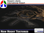
Some time ago, I purchased the Newark Liberty Intl (KEWR) by ImagineSim, but the night textures did not seem realistic. I set out to try to make them more so. This is the result of that work. Many of the scenery's night textures have been updated. The cargo areas for FedEx, UPS and UNITED Cargo now look much more realistic. The Marriott Hotel, the centerpiece of the airport and this scenery, looks considerably more realistic, as well as the terminals and the Continental Hanger and maintenance area. One of the nice unexpected results of this change is the light splash effect around the terminals; it definitely outlines the terminal area well. For those who own this scenery, I hope this enhances your flight experiences in and out of KEWR. For those who do not yet own this, but enjoy or would like to fly in and out of KEWR, it is now considered a legacy product by ImagineSim. As a result, the price was cut considerably and for a few shillings and this update, you'll have a nice addition to the airports in your FS2004 environment. I dedicate this work to all the controllers of VATSIM NYARTCC. I hope this brings more traffic your way. I want to thank ImagineSim for giving me permission to release these textures. See Readme.txt for installation instructions.
| Filename: | New_Night_Textures__Newark_Liberty_Intl_KEWR.zip |
| License: | Freeware, limited distribution |
| Added: | 27th October 2012, 03:48:59 |
| Downloads: | 2,291 |
| Author: | Jeffrey S. Bryner, Imagine Simulation |
| Size: | 1.97 MB |
| Category: Flight Simulator X - Scenery | |
| NZGA- Galatea Aerodrome (VectorLandClass, New Zealand) |
|
Images related to this file:
File Description:
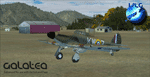
Welcome to Galatea (ICAO: NZGA), a gateway to exploring the Urewera ranges and the east coast of New Zealand. Galatea is a small and basic airstrip with only one old hanger, a public toilet and a small clubhouse on a wide plain surrounded by native bush and pine plantation near Murupara in the Bay of Plenty of New Zealand. It is a grass strip of 1025m length and 60m width and aligned 01/19 with a group rating of 8. No night lighting or fuel is available.
The FSX model includes custom textures and models placed on an aerial image. It makes extensive use of items from the free VLC object libraries which are required to be installed (download from www.vectorlandclass.co.nz downloads menu). This scenery and the VLC libraries have been funded
by sales of VectorLandClass and although you do not need VLC to use it, your purchase helps further development.
To the south west of Murupara township and sawmill is the LakeLand Helicopters base which just fits onto the photo-real coverage. Library objects have been placed here although they may not be accurate as the site was not visited when taking reference photos. This airfield makes a great stop over when flying between Rotorua, Mount Tarawera, Whakatane or Gisborne.
We hope you enjoy exploring the area!
| Filename: | NZGA_Galatea_Aerodrome_VectorLandClass_New_Zealand.zip |
| License: | Freeware, limited distribution |
| Added: | 15th November 2012, 23:35:42 |
| Downloads: | 1,127 |
| Author: | Tim Barnes / VectorLandClass |
| Size: | 45.7 MB |
| Category: Flight Simulator X - AFCAD Files | |
| ZSGS - Zhuhai Janwan Airport - Zhuhai, China |
|
File Description:
The Zhuhai Sanzao airport (ZGSD/ZUH, China), close to Macao, was built on request of someone who found it included in the FMC of PMDGs 737NGX, but missed in FSX. I used ADE and the Google based old version 2 of Plan-G (thanks to both authors) and some charts being available in the internet. However, it is equipped with standard buildings which are roughly adapted to the real dimensions well. Lighting, windsocks, taxisigns and moving jetways. Of course I added both ILS as well. There is a big exhibition apron on the airport which is modeled but blocked for AI traffic. You will see the lines of the taxiways nevertheless. The latest temporary chart (Nov 2012) shows a third apron which is not realised and I'm not planning to do so (obviously the whole site is still under construction).
As being built on a FSX island (which is now a peninsula) and default coast lines not fitting to the real position of the airport (Rwy05 was hanging in the water) I decided to compromise in a way that I corrected the area in the vicinity of the airport but respected the remaining part as it was in the default scenery. The attached pictures should give an impression even if I'm not using the pure default scenery. Therefore this little patch should be compatible to advanced mesh sceneries.
| Filename: | ZSGS___Zhuhai_Janwan_Airport__Zhuhai_China.zip |
| License: | Freeware |
| Added: | 2nd May 2013, 07:56:18 |
| Downloads: | 688 |
| Author: | Axel Birsul |
| Size: | 614.11 KB |
| Category: Flight Simulator 2004 - Scenery | |
| Union Island TVSU in the Grenadines, eastern Caribbean Version 1.1 |
|
Images related to this file:
File Description:
This is a self-contained version 1.1 that modifies the terrain flattens around the airport. I found that suddenly, and for no apparent reason, the Lesser Antilles mesh and my flattens were at war and creating hills within the airport boundary. If you are not having problems then you do not need this.
Union Island is in the southern tail of the chain of islands known as St Vincent and the Grenadines, between Canouan and Carriacou. Union is another small island, 3.5 miles long and at its widest 1.5 miles wide; the resident population is around 3,000, mostly in the two towns Clifton and Ashton. The airport is at the eastern end of the island, and has been extended into the sea on landfill. The runway is now around 2,480 feet long, aligned 08 (and with the southeast trade winds it is unlikely that you will find yourself using 26) and with a displaced threshold of 530 feet due to the hill to the west. The terminal is adjacent to a rather small apron; there is parking on the grass north of the taxiway. There are connecting flights by SVG to Barbados and the other islands and these are reflected in the AI. The airport has no lighting, and flights are obliged to land and depart in daylight hours only, outside of which the airport is closed.
| Filename: | Union_Island_TVSU_in_the_Grenadines_eastern_Caribb.zip |
| License: | Freeware, limited distribution |
| Added: | 16th June 2013, 18:46:33 |
| Downloads: | 526 |
| Author: | Roger Wensley |
| Size: | 2.02 MB |
| Category: Flight Simulator 2004 - Scenery | |
| CYPE - Peace River - Northwest Alberta, Canada |
|
Images related to this file:
File Description:
The Peace River flows east from the Rockies, joining up with the Slave River to empty into Great Slave Lake. The town is on both banks close to a bend, 245 miles northwest of Edmonton. The population is 7,000 and the surrounding area is either farmland or forest and used for winter sports; Peace River hosted the 2004 Alberta Winter Games. The airport is just over 3 miles west of the town. The runway is 5,000 feet of wide asphalt (150 feet) aligned 04/22, lit, and with PAPI. There is a second runway to the south of the main runway, 1,900 feet of grass and aligned 08/26. The apron is to the north of the runway at the eastern end and is large; there is a purpose-built terminal building, plus other hangar buildings along taxiway C that extends westward from the apron. The airport gives the impression that it is under-used; there are no long lines of parked planes waiting for the weekend and few scheduled flights. These are mainly (totally?) by Sunwest Home Aviation, but unfortunately nobody has made the textures for Sunwest and my talents do not run in that direction so I have made believable substitutions. There is also a small but obstinate AI difficulty, described in the notes.
| Filename: | CYPE__Peace_River__Northwest_Alberta_Canada.zip |
| License: | Freeware, limited distribution |
| Added: | 10th November 2013, 23:56:22 |
| Downloads: | 334 |
| Author: | Roger Wensley |
| Size: | 10.83 MB |
| Category: Flight Simulator 2004 - Scenery | |
| CYOC - Old Crow - Yukon Territory, Canada |
|
Images related to this file:
File Description:
Old Crow is in the far north of the Yukon Territory, Canada, 115 miles south of the nearest coastline and 30 miles east of the border with Alaska. The town has a population of less than 300 and the population are reliant on the caribou migration for an annual food supply replenishment. The fact that it is the only Yukon town that cannot be reached by car makes the airport important, and there are regular flights by Air North, the Yukon airline. They are included in the AI along with GA aircraft. I had several tries at matching up the Hawker Siddeley 748 with the right set of textures and I have included both here so that you do not have to go through the same torture. Thanks go to Hernan for sorting all that out, and for his textures. The airport is beside the town that is built along a bank of the Porcupine River. I have replicated the current shore line of the river that has cut a new channel at one end of the town, and I flattened the river as it was somewhat mountainous. The runway is gravel and just over 5,000 feet long, aligned 03-21. The terminal building is specific to Old Crow as I had photos, but the hangars are approximations and the village houses are only representational.
| Filename: | CYOC__Old_Crow__Yukon_Territory_Canada.zip |
| License: | Freeware, limited distribution |
| Added: | 5th December 2014, 13:31:46 |
| Downloads: | 373 |
| Author: | Roger Wensley |
| Size: | 7.58 MB |
| Category: Flight Simulator 2004 - Scenery | |
| Peace River CYPE in northwest Alberta, Canada UPDATED |
|
Images related to this file:
File Description:
This is an updated version of the original post (from 2014) made in November 2018. It provides missing textures, and deals properly with an ai problem that I thought I had already fixed. It also adds extra objects to the apron area and adds a third gate. It is complete in itself and can be installed as-is if you do not have the original post. The Peace River flows east from the Rockies, joining up with the Slave River to empty into Great Slave Lake. The town is on both banks close to a bend where the Peace turns to the north, 245 miles northwest of Edmonton. The population is 7,000 and the surrounding area is either farmland or forest. The airport is just over 3 miles west of the town. The runway is 5,000 feet of wide asphalt (150 feet) aligned 04/22, lit, and with PAPI. There is a second runway to the south of the main runway, 1,900 feet of grass and aligned 08/26. The apron is to the north of the runway at the eastern end and is large; there is a purpose-built terminal building, plus other hangar buildings along taxiway C that extends westward from the apron. The airport is experiencing an increase in scheduled and GA flights in the last few years.
| Filename: | Peace_River_CYPE_in_northwest_Alberta_Canada_UPDAT.zip |
| License: | Freeware, limited distribution |
| Added: | 10th December 2018, 17:33:25 |
| Downloads: | 128 |
| Author: | Roger Wensley |
| Size: | 24.27 MB |
| Category: Flight Simulator 2004 - Scenery | |
| Backcountry airfields for 19m terrain mesh in Idaho USA |
|
Images related to this file:
File Description:
These four backcountry fields are for use with the FSGenesis 19m mesh of Idaho, and are Big Creek, Johnson Creek, Dixie, and Sulphur Creek Ranch. They have been revised to fit and almost certainly do not work without the 19m mesh; a quick comparison with Big Creek before and after demonstrates the difference. I also have Ultimate Terrain installed. The three ingredients of terrain mesh, UT main roads, and UT streams, along with their individual margins of error, very often create conficts of space that make a grass runway impossible to site with it's correct length. Given the choice of turning off roads or streams (the terrain mesh cannot be turned off, obviously) I chose streams; the roads are less obviously incorrect, plus it matters not if roads go uphill while a climbing stream is to be avoided. On that basis the original series is reissued here for use with the 19m terrain mesh, on the presumption that you have already downloaded the original series. There are no textures or AI included as they remain the same as the originals, and the new scenery bgl's replace the originals to get the runways and grass etc in the right positions. There will be follow-on fields that are new, and all of the new ones will be only for the 19m mesh.
| Filename: | Backcountry_airfields_for_19m_terrain_mesh_in_Idah.zip |
| License: | Freeware, limited distribution |
| Added: | 29th May 2017, 04:19:43 |
| Downloads: | 124 |
| Author: | Roger Wensley |
| Size: | 2.22 MB |
| Category: Flight Simulator 2004 - Scenery | |
| Backcountry airfields for 19m terrain mesh in Idaho USA series 2 |
|
Images related to this file:
File Description:
These backcountry fields are for use with the FSGenesis 19m mesh of Idaho; they almost certainly do not work without it. The six airfields are a follow-on series to the previous four, ranging from Stanley that has a village and airfield buildings of one sort or another and even a length of asphalt runway, to Bruce Meadows that has two bathrooms. The full list from northwest to southeast is Bruce Meadows U63, Garden Valley U88, Warm Springs Creek 0U1, Stanley 2U7, Graham U45, and Smiley Creek U87. These airfields compensate for the loss of airfield flattens after the removal of AF917150 and AF917160, but there remain some now-unflattened airfields I have not included here, whether for reason of the impossibility of realistically creating it (as in the case of Flying B) or just a total lack of anything interesting about it. There may be some more follow-on fields that are new, to the north of the original four; these six are all to the south. The landclass files either change forested areas, as in Bruce Meadows, or add a village, as in Stanley. Although these are stand-alone, the presumption is that you have already installed the original four for use with the FS Genesis 19m terrain mesh, and there is a correction for Big Creek where I missed spotting a lack of flatten in one area.
| Filename: | Backcountry_airfields_for_19m_terrain_mesh_in_Idah.zip |
| License: | Freeware, limited distribution |
| Added: | 29th May 2017, 04:20:10 |
| Downloads: | 111 |
| Author: | Roger Wensley |
| Size: | 9.09 MB |
| Category: Flight Simulator X - Scenery | |
| 79C - Brennand Airport - Neenah, Wisconsin - USA |
|
File Description:
Well this is my 1st attempt at creating/editing an airport so be gentle. I created all the models in sketchup and used ADE to compile the airport. All you should have to do is unzip it and place it with your other add-on scenery and activate it in FSX.
This is for FSX ONLY. A P3D Version also exists here in the library 79C_Brennand_V1_FOR_P3D_V2.
Brennand Airport (79C) located about 4 miles southwest of Neenah WI. This airport is between KATW and KOSH. Brennand has had new ownership since 2013 and they have made many improvements in that time to 79C. So I went out there and took lots of pictures to create what I have for us now. They have built a new building and hangar which I have added along with all the other building on the airport grounds. The runway has been widened from 20 feet to 30 feet and they added PAPI lights on both runways 18 and 36 all of which I have included. I have changed the grass parking areas to reflect the way they are currently set up. (For fun parking area 8 is in the EAA Chapter 41 hangar (Hangar 11) with the door open so you can taxi out of the hangar. Now just need to figure out how to animate the hangar door).
| Filename: | 79C__Brennand_Airport__Neenah_Wisconsin__USA.zip |
| License: | Freeware |
| Added: | 10th November 2014, 01:13:30 |
| Downloads: | 431 |
| Author: | Jon Verrett |
| Size: | 36.9 MB |


© 2001-2026 AVSIM Online
All Rights Reserved
Privacy Policy |