
Where Flight Simulation Enthusiasts Gather from Around the World!
AVSIM Library - Search Results

| Category: Flight Simulator 2004 - Scenery | |
| Port McNeill CAT5 in British Columbia, Canada |

|
Images related to this file:
File Description:
Port McNeill is at the northern end of Vancouver Island, on the coast and around 20 miles east of Port Hardy. The town population is just over 2,000 and the main industry is logging, followed by sand and gravel quarrying and exporting for the construction industry. Tourism rates third.
The airport, a mile or so east of the town, provides a swift connection for nearby islands and the surrounding area to the rest of the west coast, and serves as the HQ main base for West Coast Helicopters. Their newly built large hangar and office accommodation is next to their older hangar to one side of the central public parking area, opposite the club house cum terminal and hangars. There are two runways: 06-24 which is asphalt, 2,400 feet long, and lit; and 11-29 of gravel, 3,650 feet long and also lit. There is some taxiway lighting, but not, for instance, for the connection between runways, which is in real life a ramp up to the gravel runway which is 15 feet higher. There are no regularly scheduled flights and traffic consists mainly of the West Coast helicopters, plus GA and irregular charters, the latter being mostly from Port Hardy.
| Filename: | Port_McNeill_CAT5_in_British_Columbia_Canada.zip |
| License: | Freeware, limited distribution |
| Added: | 18th November 2018, 05:49:13 |
| Downloads: | 137 |
| Author: | Roger Wensley |
| Size: | 13.29 MB |
| Category: Flight Simulator 2004 - Scenery | |
| RPLL Version 8 (Ninoy Aquino Internal Airport, Villamor Airbase, Sangley Airbase and Metro Manila) |
|
Images related to this file:
File Description:
Welcome to the latest version of the RPLL and Metro Manila scenery for FS9. This scenery is a a total rework of my previous scenery and contains a more accurate depiction of the entire metropolis. Over 4 years in the making and is the last upgrade for FS9.
This release coincides the first release sometime August of 2006. This scenery covers an area of around 1,400 sq. km. which includes major cities around Metro Manila: from Taytay in the east to Sangley in the west; from Alabang in the south to Novaliches/Caloocan-Bulacan boundaries in the north.
Sangley (RPLS) Airbase has also been redesigned (only the runway and taxiways). The entire Manila Bay coastline from Sangley to Novaliches has been recreated, adding fish-farms, correct coastal shape, breakwaters, reclaimed areas and marine ports. All major roads and river/water systems are also covered in this scenery.
The RPLL airport scenery contains 90 percent of the existing structures plus noticeable buildings around the vicinity including the new Newport City, Libingan ng mga Bayani, Fedex HQ and MIAA offices; and warehouse around rwys 06 and 24. 80 percent of the structures are individually textured. Also included in the package is Nestor d'Angelos Metro Manila buildings.
| Filename: | RPLL_Version_8_Ninoy_Aquino_Internal_Airport_Villa.zip |
| License: | Freeware, limited distribution |
| Added: | 4th August 2010, 03:48:52 |
| Downloads: | 4,611 |
| Author: | Lowil fred Espada |
| Size: | 25.37 MB |
| Category: Flight Simulator X - Scenery | |
| Airport update for Pudong Intl with New Satellite Terminal (ZSPD) |
|
Images related to this file:
File Description:
This is a reasonably accurate and up-to-date version of Pudong Intl airport and made only for FSX users, not suitable for use in P3D: I have given this airport a complete makeover which now includes the new Satellite terminal S1 and S2, assigned parking as per their website with extra overflow parking, all gates/parking numbered correctly where possible with gates included for the A380 (Gates are 24 at T1, 71,75 at T2, 504 remote stand near S1 on taxiway L2, between taxiway P2 and south of P3 and 170 at S2), taxiways and taxi signs updated to the latest charts, extra fuel trucks, drainage channels, support vehicle roads rebuilt, and many other scenery improvements and objects added, airport views are from inside the control tower (when in tower view)
I have also added the new runway 15/33 and its taxiways, although not officially in operation yet, i have opened it so AI traffic will use it and be able to get to the terminals, because there are no charts available to me there are no approaches or taxiway designators for this runway,
I will try to update the approaches and taxiways for runway 15/33 when the updated charts become available to me, please view the readme before installation.
| Filename: | Airport_update_for_Pudong_Intl_with_New_Satellite_.zip |
| License: | Freeware, limited distribution |
| Added: | 15th December 2020, 03:51:37 |
| Downloads: | 44,888 |
| Author: | Ray Smith |
| Size: | 4.07 MB |
| Category: Flight Simulator 2004 - Scenery | |
| Dawson Creek CYDQ in British Columbia, Canada UPDATED |
|
Images related to this file:
File Description:
This is a revised version of Dawson Creek CYDQ and the floats base CBD3, made primarily to provide one of the parked planes with it's textures but also to improve the apron markings and the AI. The float AI now includes Beavers and I also removed two planes that were not properly showing their textures in my current FS9 installation. The Beavers were included in my post of Nimpo Lake CAF8 and will need to be installed to show up here. This version is complete in itself and can be installed as-is if you do not have the original scenery. Dawson Creek is at 2,148 feet asl just east of the Rocky Mountains, less than 10 miles west of the BC/Alberta border and where the Rockies are at their narrowest. The population grew when the Northern Alberta Railway was extended to Dawsons Creek in 1932, and grew even more more when the Alaska Highway was built in 1942, starting from Dawsons Creek. In the 1950's the town was linked through the Rockies by a railway and a road to the BC interior, and the town grew again. Now it is static at just under 12,000 and once again has become a farming centre, with Fort St John and Grand Prairie winning out for new industry and commerce. The airport is just to the east of the town. The runway is 5,000 feet of wide asphalt (150 feet) aligned 06/24, lit, and with PAPI and approach lights. There is also a water runway for float planes, separately designated as Dawson Creek CBD3. The two effectively operate as one; traffic for both use the mandatory frequency of 122.2 and talk to one controller in one control tower. However, in FS9 the ATC for two separately designated airfields (or float fields) operates as if they are nowhere near each other and takes no notice of near misses between the two lots of planes. As a result I have put them both in un-manned tower mode so you will announce your position and intentions and select your own parking spots, either next to one of the hangars or on the grass. The aprons vary from asphalt, to concrete, onwards to gravel, and then further onwards to some gravel amid the bare dirt; I have replicated this variation as far as FS9 permits.
| Filename: | Dawson_Creek_CYDQ_in_British_Columbia_Canada_UPDAT.zip |
| License: | Freeware, limited distribution |
| Added: | 17th December 2018, 17:50:08 |
| Downloads: | 205 |
| Author: | Roger Wensley |
| Size: | 26.71 MB |
| Category: Flight Simulator 2004 - Miscellaneous Files | |
| Active Approach - LOWI (Innsbruck, Austria) |
|
File Description:
As most know the Approach and Final (VMC) for AI Traffic in FS9 is a straight in type landing and does not always consider high terrain at airports. This is do to the way that the coding is written in FS9 and it puts limits on IFR arriving aircraft. If you open runways at certain airports the AI Traffic will fly directly through a mountain once it is established on Final for a runway. What you will see with my file is a different type approach used for the way I control AI Traffic in FS9. No longer do the AI Planes use a straight in approach when landing at LOWI. My new AI Aircraft Approach coding for FS9 now uses a base leg approach so AI Traffic does not fly through the mountains. The Innsbruck Control Tower will clear all AI Traffic (IFR FP) landing either on 08 and 26 as a straight in landing even though the offset to final is 30 degrees from the runway center line. My testing shows excellent behavior of the FS9 default models, PAI models and the Aardvark planes of all sizes to execute this new type of visual approach. Read the text file for all the default enhancements added to LOWI along with a full understanding of how the new Approaches work *** Full set of Approach Charts included plus a FS2004 Default Scenery AFCAD ***
| Filename: | Active_Approach__LOWI_Innsbruck_Austria.zip |
| License: | Freeware, limited distribution |
| Added: | 10th April 2005, 05:16:39 |
| Downloads: | 9,146 |
| Author: | Jim Vile |
| Size: | 800.49 KB |
| Category: Flight Simulator X - Scenery | |
| Middle East Carrier Operations (MECOPS) |
|
Images related to this file:
File Description: This scenery has been developed for FSX Flight Simulator SP1 or SP2. It

has also been tested with Microsoft Acceleration , but compatibility is not
guaranteed by the author.
The scenery includes: Two carrier groups CVN68 and CVN69, ( carrier models from
Javier Fernandez ), two AI KC-135 tanker aircraft, AI F-18A aircraft approaching
the carrier, Navy destroyer and a Navy Cruiser as escort ships for the carrier,
a number of oil platforms and the ARS4 radar gauge which displays air targets
and boat targets.
The ARS4 radar gauge provides also a auto landing function for the carrier and a
auto tracking function for aircraft in order to support a A2A re-fueling. The
scenery package includes as well the program Arrcab, developed by Richard Hogan,
and the RCBCO gauge developed by Rob Barendregt. Arrcab or RCBCO are required to
support a catapult start from a carrier and the cable arrestor function for a
carrier landing.
This is not a load and fly package. Please take your time to read the included
documentation for the ARS4 gauge and the MECOPS scenery carefully. Do not skip
chapters because you may think, they are not important for you.
Do not start the installation of the scenery before you have finished the
reading of the documents.
For copyrights and credits please look at the documentation for this scenery.
| Filename: | Middle_East_Carrier_Operations_MECOPS.zip |
| License: | Freeware, limited distribution |
| Added: | 4th March 2013, 18:03:32 |
| Downloads: | 1,892 |
| Author: | Dietmar Loleit |
| Size: | 62.04 MB |
| Category: Flight Simulator 2004 - Scenery | |
| Itaipu Intl Airport (SGIB) Patch and Santos Dumont Statue (Iguassu Park) |
|
File Description:
If you downloaded Iguassu Falls, Itaipu Hydroelectric Power Plant, Foz do Igua���������������§u City and Land Class Package (iguassufallsbr_191388.zip) found at AVSIM, this patch corrects a bug (strange objects) in the area of Itaipu Intl Airport (SGIB) caused by some add-ons installed in your machine. This file also contains the Santos Dumont Statue (Iguassu Park) who lent all his prestige and efforts in turning the falls area into a National Park (a homage). Santos Dumont Statue modeled in Gmax by Gabriel Rodrigues (SkyHunterBR). TerraBrasilis. www.terra-brasilis.org.
Se voce baixou o cen���������������¡rio Iguassu Falls (iguassufallsbr_191388.zip) encontrado na AVSIM ou no TerraBrasilis, este patch corrige um bug (torres/postes) na ���������������¡rea do aeroporto internacional de Itaipu (SGIB) causado por alguns add-ons instalados na sua m���������������¡quina.
By Cicero Costa e Gabriel Rodrigues (SkyHunterBR). TerraBrasilis: www.terra-brasilis.org
| Filename: | Itaipu_Intl_Airport__SGIB_Patch_and_Santos_Dumont_.zip |
| License: | Freeware |
| Added: | 10th December 2010, 02:13:52 |
| Downloads: | 569 |
| Author: | Cicero Costa |
| Size: | 975.01 KB |
| Category: Flight Simulator 2004 - Aircraft Repaints, Textures and Modifications | |
| JetBlue 'Circles' Airbus A320 |
|
Images related to this file:
File Description:
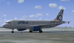
This repaint is of the very unusual but striking "JetBlue - Circles" livery for the Project Airbus A320 model (included in zip). This is a complete file and for FS9 (FS2004). While it may work in FSX, I cannot and will not confirm that as these textures have only been tested in FS9. All repainted textures, which were completely hand painted (other than the JetBlue text) have been saved and formatted in 32 bit. This model comes with all of the standard PA animations. New Alpha channels have been created to highlight the detail which has also been highlighted in terms of the doors and windows to resemble the actual aircraft. This has been an intense repaint to do due to the very nature of the livery so please PLEASE DO NOT count the circles and email me to say I missed one. If I have (which I haven't I don't think) pretend it is due to excessive weathering :) While there are some screen shots here, there are more in the Read Me file so if you have any doubts, please take a look at all of them. Installation, Distribution and Contact Details for me can be found in the enclosed PA TC Read Me File. Enjoy this paint and download it lots just so I know the work, frustration, a bottle and half of Capt Morgan and lots of Asprin were worth it :) Cheers and safe flying!
| Filename: | JetBlue_Circles_Airbus_A320.zip |
| License: | Freeware, limited distribution |
| Added: | 11th March 2012, 19:40:09 |
| Downloads: | 594 |
| Author: | Tony Cannon, Project Airbus |
| Size: | 13.54 MB |
| Category: Flight Simulator 2004 - AFCAD Files | |
| Norfolk International Airport (KORF) |
|
File Description:
Again, another instance of an airport I don't really fly into much but I decided to and yet again the default MS afcad is for lack of a better word, "nasty". This is an accuarate an AFCAD for Norfolk as it's gonna get folks. I've managed to include all terminal gates with accurate numbering and airline assignments as per the Norfolk airport website. Cargo areas and general aviation parking are also provided. This should definetely improve your experience in and out of the Norfolk Int'l Airport. As a note to users so that you do not think it was an error on my part, MS in their infinite grace decided to put the terminal almost on top of each other leaving a tiny space in between with which to park, let alone taxi. You may notice that when AI pushback they may pushback onto the aircraft behind them at times, there is, unfortunately nothing I can do about this short of removing all those gates and then you'd lose 50% of the actual gates in the airport...If someone at a future date makes some good ORF scenery, I'll update the AFCAD accordingly. Having said that, this is 10 times better then what the default MS afcad provides. Note: Independance Air is now using gate B18. The current AFCAD does not have a designator for that airline. Any of you flying
Independance or using them with AI they park at that gate.
| Filename: | Norfolk_International_Airport_KORF.zip |
| License: | Freeware |
| Added: | 28th June 2004, 03:03:11 |
| Downloads: | 1,337 |
| Author: | Jason Diaz |
| Size: | 115.67 KB |
| Category: Flight Simulator X - Missions | |
| HelicopterLighthouseMissionsVol.46.zip |
|
File Description:
Eight lighthouse tours: Bolderaga, Cape Helles, Farol do Rio Macuti, Long Point, Molo de Abrigo, Nidal, Nosy Iranja, and Cape May.These missions were programmed in Windows 10 (64bit)for FSX Acceleration and will also work in FSX Steam, P3DV3,V4,V5,and V6. However, several of these tours have specific requirements of Orbx scenery which is detailed in the .txt instructions.Photos of all the lites are included in each mission set. Once again, be sure to read the instructions in the .txt files. These missions have been thoroughly tested and should work as described. Due to large topographic differences in P3DV5 and V6, there will be peculiarities, but the missions should still work.
| Filename: | HelicopterLighthouseMissionsVol46zip.zip |
| License: | Freeware |
| Added: | 14th June 2025, 13:15:34 |
| Downloads: | 12 |
| Author: | Helomissionman |
| Size: | 62.12 MB |


© 2001-2026 AVSIM Online
All Rights Reserved
Privacy Policy |