
Where Flight Simulation Enthusiasts Gather from Around the World!
AVSIM Library - Search Results

| Category: Flight Simulator X - Scenery | |
| TACAN Replacements - US Complete |

|
File Description:
By default, all of the TACAN navigational aids present within FSX have the bearing component turned off, so as to properly represent the real world result of tuning in the DME component of a TACAN with a civilian plane. However, this limits their functionality when you wish to use them in conjunction with a plane (generally military) equipped with a representation of a functioning TACAN system.
This download contains 105 fixed/adjusted/changed navigational aids for the United States to represent all currently active TACAN stations. These navigational aids have all had the bearing component turned on, so that they are completely usable for navigation within the sim.
This package completely replaces any previous partial TACAN release for the United States.
| Filename: | TACAN_Replacements__US_Complete.zip |
| License: | Freeware |
| Added: | 17th June 2014, 16:15:09 |
| Downloads: | 1,227 |
| Author: | Jim Stewart |
| Size: | 111.71 KB |
| Category: Flight Simulator X - Scenery | |
| Helicopter test at Chittagong |
|
Images related to this file:
File Description:

Chittagong, in Bangladesh, is known for its ship dismantling industry. The scenery is a piloting test, but also a way to make aware of the workers conditions. Even if some building have been added to VGEG, it is not an airport scenery.
| Filename: | Helicopter_test_at_Chittagong.zip |
| License: | Freeware |
| Added: | 20th June 2014, 11:49:42 |
| Downloads: | 333 |
| Author: | Jean-Pierre Fillion |
| Size: | 1.77 MB |
| Category: Flight Simulator X - Scenery | |
| Improved and/or New terrains around Dijon, France |
|
Images related to this file:
File Description:
That FSX freeware is adding or improving terrains around Dijon, France, with Beaune-Challanges (LFGF), Dijon-Darois (LFGI), Nuits-Saint-Georges-La Berchere (LFGZ), Pouilly-en-Auxois-Maconge (LFEP), and Til-Chatel (LFET).**NOTE: A better and easier choice is to install the latest, stand-alone 3.0 version, at "dijonnais_terrains_3.0.zip"!
| Filename: | Improved_andor_New_terrains_around_Dijon_France.zip |
| License: | Freeware |
| Added: | 16th July 2014, 16:37:20 |
| Downloads: | 290 |
| Author: | Gerard Guichard |
| Size: | 272.13 KB |
| Category: Flight Simulator X - Scenery | |
| Improved and/or New terrains around Dijon, France - Version 2.0 |
|
Images related to this file:
File Description:

That is our version 2.0 to our FSX freeware adding or improving terrains around Dijon, France, with Beaune-Challanges (LFGF), Dijon-Darois (LFGI), Nuits-Saint-Georges-La Berchere (LFGZ), Pouilly-en-Auxois-Maconge (LFEP), and Til-Chatel (LFET) (dijonnais_terrains.zip). Comes with a French readme too. By G. Guichard.
Note: version 2.0 is a stand-alone version, it does not require version 1.0 to work. A better and easier choice is to install the latest, stand-alone 3.0 version, at "dijonnais_terrains_3.0.zip"!
| Filename: | Improved_andor_New_terrains_around_Dijon_France__V.zip |
| License: | Freeware |
| Added: | 16th July 2014, 16:37:55 |
| Downloads: | 689 |
| Author: | Gerard Guichard |
| Size: | 301.77 KB |
| Category: Flight Simulator X - Scenery | |
| TACAN Replacements - Canada |
|
File Description:
By default, all of the TACAN navigational aids present within FSX have the bearing component turned off, so as to properly represent the real world result of tuning in the DME component of a TACAN with a civilian plane. However, this limits their functionality when you wish to use them in conjunction with a plane (generally military) equipped with a representation of a functioning TACAN system.
This download contains 12 modified TACAN and 1 modified VOR beacon found in Canada. 11 TACAN's have been updated to display azimuth / bearing information, 1 has been decommissioned, and 1 VOR has been updated to reflect it's status as a VOR/DME.
| Filename: | TACAN_Replacements__Canada.zip |
| License: | Freeware |
| Added: | 14th May 2014, 17:20:09 |
| Downloads: | 266 |
| Author: | Jim Stewart |
| Size: | 23.81 KB |
| Category: Flight Simulator X - Scenery | |
| Altitude 2K |
|
Images related to this file:
File Description:

Altitude2K is a AI hotel, with 3,000-feet runway, flying (10 knots) around Iceland. Unrealistic but funny!
| Filename: | Altitude_2K.zip |
| License: | Freeware |
| Added: | 4th March 2015, 23:38:56 |
| Downloads: | 187 |
| Author: | Jean-Pierre Fillion |
| Size: | 1.33 MB |
| Category: Flight Simulator X - Scenery | |
| Decimomannu Mil. - Crash Detection Fix |
|
Images related to this file:
File Description:

Decimomannu Mil. Scenery FIX for those running FSX / P3D with Crash Detection turned On who are experiencing crash detection issues. This fix will solve these problems. Apologies!
| Filename: | Decimomannu_Mil__Crash_Detection_Fix.zip |
| License: | Freeware |
| Added: | 17th March 2015, 11:13:36 |
| Downloads: | 1,411 |
| Author: | Dave Torkington & Guy Neild |
| Size: | 2.79 MB |
| Category: Flight Simulator X - Scenery | |
| KPVG - Hampton Roads Executive Airport - Virginia, USA **Update** |
|
Images related to this file:
File Description:
FSX Scenery - This is an update for my FSX version of Hampton Roads Executive Airport scenery, KPVG. (hampton-roads_kpvg_fsx_2014.zip) In September 2014, Hampton Roads unveiled their new runway 10/28 replacing the old 10/28. The new runway is 5350 ft. in length and 100 ft. wide. For your Flight Sim flying pleasure by John B. Loney, Jr.
| Filename: | KPVG__Hampton_Roads_Executive_Airport__Virginia_US.zip |
| License: | Freeware, limited distribution |
| Added: | 30th December 2014, 01:23:14 |
| Downloads: | 530 |
| Author: | John B. Loney, Jr. |
| Size: | 282.05 KB |
| Category: Flight Simulator X - Scenery | |
| KABE - Lehigh Valley Intl Airport - Allentown, PA, USA (Addition of ILS 24) |
|
File Description:
This is an update of the stock airport that adds glide slope, DME and localizer to runway 24.
| Filename: | KABE__Lehigh_Valley_Intl_Airport__Allentown_PA_USA.zip |
| License: | Freeware |
| Added: | 7th January 2015, 14:18:07 |
| Downloads: | 187 |
| Author: | Andrew Morkunas |
| Size: | 52.82 KB |
| Category: Flight Simulator X - Scenery | |
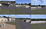
| KMKJ - Mountain Empire Airport - Virginia, USA |
|
Images related to this file:
File Description:
Mountain Empire Airport (ICAO: KMKJ, FAA LID: MKJ) is a public use airport in Smyth County, Virginia, United States.[1] It located nine nautical miles (10 mi, 17 km) northeast of the central business district of Marion (in Smyth County)[1] and 13 nautical miles (15 mi, 24 km) west of Wytheville (in Wythe County).[2] The airport is situated between Interstate 81 and U.S. Route 11 (Lee Highway), near Groseclose. It is owned by Smyth Wythe Airport Commission.
This is a complete re-work of the airport. Added taxiway, additional parking aprons and custom buildings.
Created with Airport Design Editor by ScruffyDuck Software using current FAA documentation and Google Earth measurements, this package offers a replacement for FSX's stock airport. All these enhancements are as close to the real airport as I can get with stock library objects and custom buildings.
| Filename: | KMKJ__Mountain_Empire_Airport__Virginia_USA.zip |
| License: | Freeware |
| Added: | 25th January 2015, 15:55:52 |
| Downloads: | 308 |
| Author: | Wayne Roberts |
| Size: | 339.5 KB |
© 2001-2026 AVSIM Online
All Rights Reserved
Privacy Policy |