
Where Flight Simulation Enthusiasts Gather from Around the World!
AVSIM Library - Search Results

| Category: Flight Simulator X - Scenery | |
| RAF Wickenby (1940s) |

|
File Description:
RAF Wickenby was a purpose built Royal Air Force station constructed late 1942 and early 1943 it had two T2 type
hangars and one B1 type. The B1 and one of the T2 hangars can still be seen on the airfield site. The T2 near the
threshold of runway 21 was recently acquired by the airfield owners and after many years of industrial use is now,
once more, an aircraft hangar.
The airfield covered about 600 acres (2.4 km2), and had the usual three runway configuration with perimeter track,
hard standings, a brick watchtower and numerous brick and metal buildings for the aircrews and ground staff. A number
of the buildings were to the east (Communal Site, Living Quarters, WAAF Quarters) and stretched to and beyond the
Lissington road - a road travelled many an evening by the airmen and women who visited their favourite watering hole,
the White Hart at Lissington. The Sick Quarters were to the south of the airfield together with a Communal Site and
Living Quarters.
The north part of the former airfield is now known as Wickenby Aerodrome, which is a grass and concrete airfield. A
road from Holton cum Beckering to Snelland runs right over the former airfield. Companies based at the airfield are
Thruster Aircraft who make microlight planes; Fly365 Ltd who fly pleasure flights; and Rase Distribution - a haulage
firm. Planes using the airfield have to make contact first with the control tower at RAF Waddington.
The Watch Office is the home of the RAF Wickenby Memorial Collection and the Wickenby Archive, a museum and collection
of memorabilia and archive dedicated to the memory of the Squadrons who served here.
| Filename: | RAF_Wickenby_1940s.zip |
| License: | Freeware |
| Added: | 10th March 2017, 14:46:25 |
| Downloads: | 136 |
| Author: | Terry Boissel |
| Size: | 15.14 KB |
| Category: Flight Simulator X - Scenery | |
| RAF Wigsley |
|
File Description:
RAF Wigsley is a little know station just inside the border of Nottinghamshire, It had the standard layout of a bomber
airfield and was used as a satellite for RAF Swinderby.
For a more detailed account of this station Paul Marshal has written a very interesting piece at this link
http://www.harby.org.uk/RAFWigsley.htm
| Filename: | RAF_Wigsley.zip |
| License: | Freeware |
| Added: | 10th March 2017, 14:46:38 |
| Downloads: | 118 |
| Author: | Terry Boissel |
| Size: | 1.4 MB |
| Category: Flight Simulator X - Scenery | |
| RAF Skipton On Swale |
|
File Description:
RAF Skipton On Swale is a former Royal Air Force station operated by RAF Bomber Command during the Second World War.
The village of Sandhutton is located just to the east. RAF Skipton-on-Swale was a sub-station of RAF Leeming.
The airfield opened in autumn 1942, becoming operational in May 1943, originally a 4 Group facility and first hosted
420 Squadron, Royal Canadian Air Force (RCAF), which moved to RAF Middleton St. George in October 1942. Skipton was
assigned to No. 6 Group, Royal Canadian Air Force (RCAF) in January 1943. RCAF squadrons stationed here included 424
Squadron, No. 432 Squadron (which moved to RAF East Moor in September 1943), and 433 Squadron. Both squadrons flew the
Halifax bomber until replaced by the Lancaster in January 1945. 424 Squadron lost 52 aircraft and 433 Squadron lost 38
aircraft.
When Nos. 424 and 433 Squadrons were disbanded in October 1945 the airfield was closed. The station was not used again
and has since reverted largely to farmland. The site is home to turkey and pig farms.
Source:Wikipedia
| Filename: | RAF_Skipton_On_Swale.zip |
| License: | Freeware |
| Added: | 11th March 2017, 18:03:07 |
| Downloads: | 122 |
| Author: | Terry Boissel |
| Size: | 157.85 KB |
| Category: Flight Simulator X - Scenery | |
| RAF East Moor |
|
File Description:
RAF East Moor was opened in 1942 and was originally a 4 Group facility and first hosted No. 158 Squadron RAF which had moved from RAF Driffield on 6 June 1942. The squadron flew the Handley Page Halifax Mk. II with detachments at RAF Beaulieu and RAF Manston before moving to RAF Rufforth on 6 November 1942.
Royal Canadian Air Force use
The first squadron was No. 429 Squadron RCAF which formed at the airfield on 7 November 1942 initially only flying the Vickers Wellington Mk.III until January 1943 when the Wellington Mk. X was added. The squadron left on 13 August 1943 going to RAF Leeming where the unit re-equipped with Halifaxes. On 19 September 1943 the next squadron arrived being 432 Squadron which initially used the Avro Lancaster Mk.II before being re-equipped with the Halifax Mk. III in February 1944 and the Mk. VII Halifax in July 1944. The squadron disbanded on 15 May 1945 at the airfield.
The last Canadian squadron to use the airfield was 415 Squadron which flew the Halifax III from 26 July 1944. The unit inherited the additional Mk.VII versions during March 1945 but disbanded shortly after on 15 May 1945 at the airfield.
Royal Air Force use
Not long after the last Canadian squadron disbanded the airfield was handed back to the Royal Air Force (RAF). The first RAF unit to use the airfield was No. 54 Operational Training Unit (OTU) which had moved in during November 1945 flying the de Havilland Mosquito. By May 1946 No. 288 Squadron RAF joined with their Supermarine Spitfire IX's and their Vultee Vengeance Mk. IV's with a detachment at RAF Acklington. The squadron disbanded on 15 June 1946. No. 54 OTU stayed until June 1946 when the unit moved to RAF Leeming but a detachment stayed until 15 November 1946.
The airfield closed to flying in November 1946. Most of the buildings were taken down and the land has reverted largely to agricultural use.
| Filename: | RAF_East_Moor.zip |
| License: | Freeware |
| Added: | 14th March 2017, 19:41:08 |
| Downloads: | 128 |
| Author: | Terry Boissel |
| Size: | 154.38 KB |
| Category: Flight Simulator X - Scenery | |
| Macedonia 2014 OpenStreetMap Scenery |
|
Images related to this file:
File Description:
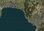
OSM based scenery of Macedonia.
Data from OSM:
Roads, railways, lakes, rivers, streams.
Land class is modified for largest cities, towns and villages.
| Filename: | Macedonia_2014_OpenStreetMap_Scenery.zip |
| License: | Freeware |
| Added: | 18th April 2014, 07:03:34 |
| Downloads: | 541 |
| Author: | Sami Toronen |
| Size: | 1.67 MB |
| Category: Flight Simulator X - Scenery | |
| Working TACAN Beacons in the Netherlands, version 2 |
|
Images related to this file:
File Description:
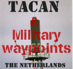
In real-life TACAN beacons require a TACAN receiver to receive the course (OBS)
information of the beacon. With a civil VOR/DME receiver you only receive the
distance (DME) to the beacon.
The problem in FS is that there are no dedicated TACAN gauges, so it's not
possible to perform TACAN approaches, because this requires course information
of the beacon.
To overcome this problem i've modified the TACAN beacons in the Netherlands so
you can fully use them with civil receivers. And so are able to fly TACAN
approaches.
Also added almost all military waypoints in the Netherlands for various military
routes. These will show up in the default GPS and other gauges which use the
default FS database. Build and tested under FSX, should however also work under
FS2004.
| Filename: | Working_TACAN_Beacons_in_the_Netherlands_version_2.zip |
| License: | Freeware, limited distribution |
| Added: | 20th April 2014, 13:26:49 |
| Downloads: | 264 |
| Author: | Marcel Ritzema |
| Size: | 22.05 KB |
| Category: Flight Simulator X - Scenery | |
| Hilversum small texture update for NL2000 V4.x |
|
Images related to this file:
File Description:

This zip-file contains replacement textures which improve and bring the big hangar
at Hilversum up to date. This hangar (Benair/Vliegschool Hilversum) has be recently
painted in real-life in fresh white and light blue colours.
The repaint was in principle designed for private use but decided to release it
so more people can enjoy it.
This texture are only compatible with FSX in combination with the NL2000 scenery
version 4.0 NL2000 website: www.nl-2000.com
This addon is in communication with the NL2000 Team approved by NL2000. The NL2000 team
does NOT provide support for this addon. So for support of this addon please contact me.
| Filename: | Hilversum_small_texture_update_for_NL2000_V4x.zip |
| License: | Freeware, limited distribution |
| Added: | 20th April 2014, 13:27:03 |
| Downloads: | 531 |
| Author: | Marcel Ritzema |
| Size: | 4.64 MB |
| Category: Flight Simulator X - Scenery | |
| 2 Fronson Hangars |
|
Images related to this file:
File Description:
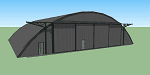
This model was created to be placed in FSX as airport scenery using Airport Design Editor.
I created it for my own use when i was re-creating RNAS HMS Nuthatch which was a Naval Airstation near Anthorn on the Solway Coast in Cumberland (now Cumbria), United Kingdom.
History of RNAS HMS Nuthatch...
Work began on building an airfield at Anthorn for the Fleet Air Arm in late 1943, with Royal Naval Air Station Anthorn, or HMS Nuthatch opening on 7 September 1944, with three tarmac runways.
It was the base of No. 1 Aircraft Receipt and Despatch Unit (No. 1 ARDU), which had the job of receiving aircraft fresh from manufacturers, modifying them to Service standards and despatching them to operational squadrons, with the unit specialising in the Vought F4U Corsair.
No. 1 ARDU continued to operate from Anthorn following the end of the Second World War, while a number of Fleet Air Arm Squadrons were also based at the airfield in the immediate post war years.
The airbase shut down in March 1958.
The Airfield is now the site of a VLF/LF transmitter used for transmitting orders to Submarines, it is also home to three atomic clocks for transmitting Britains time signal transmissions.
None of the Hangars (11 Pentad and 22 Fromson) survive at the site but their concrete standings are still visable.
Depicted here are representations of the Fromson type hangers created from dimensions in a 1947 survey.
I created the model using Google Sketchup and converted it for use in FSX using Model ConverterX.
This is my 1st attempt at scenery creation and is therefore pretty basic.
There are no known issues and it works fine in FSX.
| Filename: | 2_Fronson_Hangars.zip |
| License: | Freeware |
| Added: | 8th June 2014, 07:13:54 |
| Downloads: | 251 |
| Author: | Mark John Byers |
| Size: | 1.4 MB |
| Category: Flight Simulator X - Scenery | |
| Ridge Soaring 79N Julian PA |
|
Images related to this file:
File Description:
Ridge Soaring Gliderport (79N) is a public-use glider airport located two nautical miles (4 km) southwest of the central business district of Unionville, in Centre County, Pennsylvania, United States. It is privately owned by Knauff & Grove, Inc. Tom Knauff and Doris grove are among the whos who in American and International soaring community.
Portions of the 1999 movie The Thomas Crown Affair were filmed here.
Co-owner Thomas L. Knauff set five FAI world records, and over 50 NAA national records flying from this airport.
Co-owner Doris Grove set three FAI feminine world records flying from this airport, and was the first woman to fly a glider more than 1000 km.
This FBO airport is world famous for ridge, thermal and wave soaring. It is located on U.S. Route 220 (alternate) 8 miles south of Interstate 80, between Unionville and Julian, at the base of the Bald Eagle Mountain ridge. It is approximately 10 miles from State College and approximately midway between Altoona and Lock Haven in the Bald Eagle Valley. Visitors can look at an entire wall of U.S. National and World records that have been set from this airfield.
Sadly as with so many small airports, Ridge Soaring is in risk of disappearing. for sale for many years, with no takers it may be sold to developers and disappear forever.
In FSX the airport was on the wrong side of the highway and cut into a mountain, I moved it to its proper location and heading, made the runway the correct size and heading, and added all the current buildings.
| Filename: | Ridge_Soaring_79N_Julian_PA.zip |
| License: | Freeware |
| Added: | 11th June 2014, 16:24:59 |
| Downloads: | 292 |
| Author: | Jon Davidson |
| Size: | 16.52 MB |
| Category: Flight Simulator X - Scenery | |
| Eagle Field - Port Matilda, PA |
|
Images related to this file:
File Description:
Eagle field- 09PA Port Matilda PA.
Private Glider field Owned by Karl Striedieck. Karl is a world record setting glider pilot and a member of the U.S. Soaring Hall of Fame. He was an early pioneer of ridge soaring in the Ridge-and-valley Appalachians in the 1960s, ultimately setting nine world records flying gliders there. He was selected for the U.S. national soaring team 12 times, and won a silver medal in the world championships in 1978 and 1983.
Mr. Striedieck was a U.S. Air Force pilot from 1959 to 1962, flying the F-86 Sabre and F-102 Delta Dagger, then continued his military service until 1981 in the Pennsylvania Air National Guard, where he transitioned to the A-7 Corsair II. A year before graduating from Pennsylvania State University in 1965, he started flying gliders when he and Bill Clark co-founded the Nittany Soaring Club, flying out of the former State College Air Depot. He has over 15,000 flying hours, with nearly half of that total in gliders.
Mr. Striedieck moved his home to the Eagle Field private airport on top of Bald Eagle Mountain, near State College, Pennsylvania in 1966, and now lives there with his second wife, Iris.
Basically a manicured farm field, this private glider field offers access to the famous ridge lift of central Pennsylvania.Nearby Ridge Soaring is another one of my airfields available.
| Filename: | Eagle_Field__Port_Matilda_PA.zip |
| License: | Freeware |
| Added: | 11th June 2014, 16:30:28 |
| Downloads: | 322 |
| Author: | Jon Davidson |
| Size: | 16.52 MB |
© 2001-2026 AVSIM Online
All Rights Reserved
Privacy Policy |