
Where Flight Simulation Enthusiasts Gather from Around the World!
AVSIM Library - Search Results

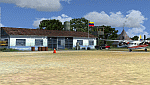
| Category: Flight Simulator X - Scenery | |
| SLET - El Trompillo Airport - Santa Cruz de la Sierra, Bolivia |

|
File Description:
El Trompillo Airport (IATA: SRZ, ICAO: SLET) is located in the south part of Santa Cruz de la Sierra, Bolivia, about 2 km (1.25 miles) away from the central plaza. Airport type:(Public / Military).
After a series of improvements, in June 3, 2014 Airport regained its status as an international airport by converting to Santa Cruz de la Sierra in Bolivia the only city with two international airports, international airport suitable as retention and/or support times of high demand in the Viru Viru Airport (ICAO: SLVR) can not supply completely.
The airport operates 24 hours and resides at an elevation of 1,371 ft (418 m) above mean sea level. Have one runway designated 15/33 with an asphalt surface measuring 8,967 by 114.82 ft (2,733 m by 35 m), El Trompillo Tunnel for vehicles, passes under the runway and connects the 4th ring (considered the most important highway in the city).
Compatible with both FSX and P3D.
| Filename: | SLET__El_Trompillo_Airport__Santa_Cruz_de_la_Sierr.zip |
| License: | Freeware |
| Added: | 19th November 2015, 09:49:14 |
| Downloads: | 1,830 |
| Author: | Marcos A. Rivas Torrez |
| Size: | 16.68 MB |
| Category: Flight Simulator X - Scenery | |
| Icabaru (SVIC) & Wonken (SVUQ) - Venezuela |
|
Images related to this file:
File Description:
Two small airports located south of Venezuela, especially for VFR flights:
- Icabaru is one of the oldest mining towns in the region located near the border with Brazil.
- Wonken is located in the Canaima National Park, only 15 minutes by plane from Santa Elena de Uairen.
Photo-terrain area improved with Autogen files. Not compatible with versions prior to FSX. Also includes a friendly Auto-Install.
| Filename: | Icabaru_SVIC__Wonken_SVUQ__Venezuela.zip |
| License: | Freeware |
| Added: | 18th January 2014, 16:29:41 |
| Downloads: | 965 |
| Author: | David Maldonado |
| Size: | 83.37 MB |
| Category: Flight Simulator X - Scenery | |
| Cape_Verde_Mesh |
|
File Description:
To improve performance, FSX updated with SP1 loads DEM files in threads and only
the closer terrain (about 10 NM from the point of view) is rendered in high
detail, while at far distances FSX shows up its default low resolution mesh,
if it is not available a multi-resolution one. This terrain mesh file was multilod compiled from 90m SRTM2 source data, reprocessed with 3DEM to remove voids and spikes, providing a 76.4m (LOD9) horizontal resolution topography intended
for use only in FSX updated with SP1.
It covers the Cape Verde, a group of islands in the North Atlantic Ocean, that consist of two small archipelagos, about 400 miles off the western coast of Senegal (Africa), including: Boa Vista, Brava, Maio, Mosteiros, Paul, Praia, Porto Novo, Ribeira Grande, Sal, Santa Catarina, Santa Cruz, Sao Domingos, Sao Filipe, Sao Miguel, Sao Nicolau, Sao Vicente and Tarrafal (Geographic coordinates: 16ºN/24ºW).
Authors:
Hely Heck Junior - Magrao ( [email protected] ) and Jose Lobo (
[email protected] ) TerraBrasilis: www.terra-brasilis.org
| Filename: | Cape_Verde_Mesh.zip |
| License: | Freeware |
| Added: | 21st June 2007, 16:26:23 |
| Downloads: | 4,332 |
| Author: | Hely Heck Jr. and José Lôbo |
| Size: | 1.55 MB |
| Category: Flight Simulator X - Scenery | |
| San Jose International Airport [KSJC] |
|
Images related to this file:
File Description:
Welcome to San Jose International Airport [KSJC] for FSX!
The Gateway airport for Silicon Valley sits in Santa Clara at the south end of the San Francisco Bay.
The runways have been adjusted to their current length. Runway 11/29 is gone and is now
taxiway W1. A new taxiway (W) was added for western exits from 12R/30L
The VOR has been updated to the current configuration.
All the buildings (with the exception of the tower) are custom.
| Filename: | San_Jose_International_Airport_KSJC.zip |
| License: | Freeware, limited distribution |
| Added: | 9th March 2020, 18:17:07 |
| Downloads: | 774 |
| Author: | Brett Delana |
| Size: | 16.61 MB |
| Category: Flight Simulator X - Scenery | |
| SVPR |
|
File Description:
Manuel Carlos Piar Guayana Airport (IATA: PZO, ICAO: SVPR), is an airport serving the cities of Ciudad Guayana and Puerto Ordaz, Venezuela. Airlines and destinations: Aeropostal Alas de Venezuela (Caracas, MaturÃ�ÂÂn), Aserca Airlines (Barcelona, Valencia and Caracas), Avior Airlines (Caracas), Conviasa (Porlamar), Rutaca (Caracas, Porlamar, Ciudad Bolivar), Canaima Tours (Canaima), Serami (Porlamar, Maturin, Barcelona, Canaima, Santa Elena de Uairen), Rainbow air (Porlamar)
This file has the right coordinates, with the apron and characteristics of the airport. The runways and runways were resized the gates placed on correct location.
| Filename: | SVPR.zip |
| License: | Freeware |
| Added: | 21st April 2011, 03:53:06 |
| Downloads: | 856 |
| Author: | Anwar Gonzalez |
| Size: | 8.84 KB |
| Category: Flight Simulator X - Scenery | |
| KSNA, John Wayne-Orange County Airport |
|
Images related to this file:
File Description:

John Wayne Airport (IATA: SNA, ICAO: KSNA, FAA LID: SNA) is an airport in an unincorporated area in Orange County, California, with its mailing address in the city of Santa Ana, which is also the county seat, hence the International Air Transport Association (IATA) airport code. The main entrance to the airport is off of MacArthur Blvd in Irvine, the city that abuts the airport from the north and east. Newport Beach and Costa Mesa form the southern and western boundaries, respectively, together with a small unincorporated area along the Corona del Mar (73) Freeway. Santa Ana lies just north, not actually touching the airport directly. Originally named Orange County Airport, the county Board of Supervisors renamed it in 1979 to honor the actor John Wayne, who resided in neighboring Newport Beach and died that year. It also became the first airport to be named after an entertainer.
The main runway, at 5,701 feet (1,738 m), is one of the shortest of any major airport in the United States, resulting in most passenger aircraft operating from the airport to be no larger than the Boeing 757. However, some larger cargo aircraft, such as the FedEx A310/300, fly from SNA. Some gates are built to handle planes up to the size of a Boeing 767, which can operate with payload/fuel load restrictions. No wide-body passenger aircraft are currently in scheduled service at the airport.
| Filename: | KSNA_John_WayneOrange_County_Airport.zip |
| License: | Freeware, limited distribution |
| Added: | 11th October 2011, 08:25:20 |
| Downloads: | 10,999 |
| Author: | Mateusz Stabryla MK-Studios |
| Size: | 66.92 MB |
| Category: Flight Simulator X - Scenery | |
| Assisi City - Assisi, Perugia, Italy |
|
File Description:
The filmmakers FSX they have not taken into account the city's Italian,
therefore, I decided to make some Italian cities such as the city of Assisi N43.04.28 E12.36.22 in honor of St. Francis and Pope Francis.
The scenarios are always built airports, but few are interested in the VFR flight
where the details of the land and the cities are important for the flight.
In the package you will find the file AssisiCity.bgl that will be placed at the
addon scenery folder and subfolder scenery automatically when FSX scenery you will find it
in the scenario.
In scenery you can fly, church of San Francis and as an important reference VFR also the church of Santa Chiara in the valley near city Assisi.
Good flight at all.
| Filename: | Assisi_City__Assisi_Perugia_Italy.zip |
| License: | Freeware |
| Added: | 12th July 2015, 15:44:35 |
| Downloads: | 1,007 |
| Author: | Pasquale Marrulli |
| Size: | 1.6 KB |
| Category: Flight Simulator X - Scenery | |
| Gustavo Rojas Pinilla International Airport (SKPS) 2011 |
|
File Description:
Gustavo Rojas Pinilla International Airport (IATA: ADZ, ICAO: SKSP) is the leading airport in the archipelago of San Andres, Providencia and Santa Catalina, which has enough capacity to receive large aircraft, due to a number of
charter flights and seasonal in different parts of America and Europe.
This file has the right coordinates, with the apron and characteristics of the airport. The runways were reoriented to the correct direction, runway were re-sized the gates placed on correct location and number, FAC was placed
(Colombian Air force and Colombian National Army) all the airport charts required to navigate in and out of this airport can be found at www.aerocivil.gov.co/ under Informacion Aeronautica click AIP; on AIP
click Aerodromos then click at SKSP.
| Filename: | Gustavo_Rojas_Pinilla_International_Airport_SKPS_2.zip |
| License: | Freeware |
| Added: | 23rd August 2011, 02:26:49 |
| Downloads: | 1,675 |
| Author: | Anwar Gonzalez |
| Size: | 10.03 KB |
© 2001-2026 AVSIM Online
All Rights Reserved
Privacy Policy |