
Where Flight Simulation Enthusiasts Gather from Around the World!
AVSIM Library - Search Results

| Category: Flight Simulator X - Scenery | |
| California Central Coast Scenery for FSX with Megascenery Earth (Default Mesh Terrain) |

|
Images related to this file:
File Description:
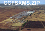
Revised 1/7/10 for upload to Avsim.COM. CCFSXMSFix is incorporated so not required.
This is an earlier version of CCC Megascenery Earth scenery that doesn't require FSGenesis Mesh Terrain. See CCFSXMSG.ZIP for the FSGenesis Mesh version.
This scenery covers the California coastal region from N36���°10' (Coalinga) to N34���°25' (Santa Barbara) and from the coast East to W119���°40'. It is a version of my previous California Central Coast scenery redesigned and expanded to work with MegaScenery Earth from PC Aviator Inc. Many airstrips in the area covered by this scenery have been added or enhanced for a total of 27 airports/airstrips in the area. Several areas of interest such as the Santa Barbara marina, Morro Bay, etc. are also included for a total of 41 points of interest. All airports/airstrips and related structures have been adjusted and realigned to conform to actual positions and dimensions as indicated by the MegaScenery satellite textures. In addition, there are 6 invisible water runways for use by AI floatplane traffic. MegaScenery California-13, -14 and -15 are required for this scenery to make sense. I also used California-12, -28 and -29 when constructing the scenery but they could be considered optional.
| Filename: | California_Central_Coast_Scenery_for_FSX_with_Mega.zip |
| License: | Freeware |
| Added: | 7th January 2010, 21:28:45 |
| Downloads: | 1,559 |
| Author: | Al Wheeler |
| Size: | 8.12 MB |
| Category: Flight Simulator X - Scenery | |
| Santa Cruz de la Sierra - Bolivia |
|
File Description:
Scenery Photoreal: Santa Cruz de la Sierra, Bolivia
Santa Cruz de la Sierra: (English: Holy Cross of the Mountain Range), commonly known as Santa Cruz, is the
capital of the Santa Cruz department in eastern Bolivia (17 45', South, 63 14', West)at 416 m above sea level.
The city of Santa Cruz is located not far from the easternmost extent of the Andes Mountains and they are
visible from some parts of the city its Situated too on the Pirai River.
The city of Santa Cruz and its metropolitan area are home to over 70% of the population of the department and
it is one of the fastest-growing cities in the world.
Airports: (NOT included in this package, just Scenery Photoreal of the city)
Viru Viru International Airport (IATA: VVI, ICAO: SLVR) in Santa Cruz de la Sierra, Bolivia is Bolivia's largest
international airport. Viru Viru handles domestic, regional, and international flights from Bolivia to
North America, South America and Europe and is the hub for Bolivia's biggest airline Boliviana de Aviacion (BoA).
The airport is able to handle the largest commercial jets.
El Trompillo Airport (IATA: SRZ, ICAO: SLET) is located in the south part of Santa Cruz, Bolivia, about 2 km
(1.25 miles) away from the central plaza. Airport type:(Public / Military).
Compatible with both FSX and P3D.
| Filename: | Santa_Cruz_de_la_Sierra__Bolivia.zip |
| License: | Freeware |
| Added: | 23rd June 2015, 17:09:33 |
| Downloads: | 1,707 |
| Author: | Marcos A. Rivas Torrez |
| Size: | 69.85 MB |
| Category: Flight Simulator X - Scenery | |
| Santa Izabel do Rio Negro |
|
File Description:
3D Scenery of Tapuruquara Airport and Santa Izabel do Rio Negro city (landclass) located on Amazonas, Brazil. By Alexandre Alves
| Filename: | Santa_Izabel_do_Rio_Negro.zip |
| License: | Freeware |
| Added: | 22nd August 2017, 05:03:37 |
| Downloads: | 599 |
| Author: | Alexandre Alves |
| Size: | 2.41 MB |
| Category: Flight Simulator X - Scenery | |
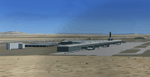
| SBGO - Santa Genoveva International Airport - Goiania - Brazil |
|
Images related to this file:
File Description:
SBGO - Santa Genoveva International Airport - Goiania - Goias - Brazil - Simple default airport improvement to make it more realistic. It also includes AFCAD modifications.
| Filename: | SBGO__Santa_Genoveva_International_Airport__Goiani.zip |
| License: | Freeware |
| Added: | 27th January 2013, 00:55:32 |
| Downloads: | 5,194 |
| Author: | Roberto Zanolli |
| Size: | 421.51 KB |
| Category: Flight Simulator X - Scenery | |
| Santa Maria Airport - SSKG |
|
File Description:
Campo Grande, Brazil - Santa Maria Airport (SSKG) - v0.1
Created in November/2019
With new runway and Taxiway sizes.
Replacement for Default FSX/FSX:SE SSKG Scenery.
Lightweight, and concise with reality, not the best, but much better than FSX Default Scenery. Enough for some fun/trainning.
This Scenery will be part of SBCG Airports Package (SBCG, SSIE, SSKG, SSAY), which is under development.
| Filename: | Santa_Maria_Airport__SSKG.zip |
| License: | Freeware, limited distribution |
| Added: | 7th November 2019, 17:39:15 |
| Downloads: | 391 |
| Author: | Francisco Malheiros |
| Size: | 5.32 MB |
| Category: Flight Simulator X - Scenery | |
| Mesh Correction |
|
File Description:
These files correct wrong shape of FSX mesh at Lagoa Santa and Governador Valadares, Minas Gerais, Brazil, fixing the elevation to the real height level.
| Filename: | Mesh_Correction.zip |
| License: | Freeware, limited distribution |
| Added: | 16th March 2007, 01:55:24 |
| Downloads: | 942 |
| Author: | Cesar Marinho |
| Size: | 134.9 KB |
| Category: Flight Simulator X - Scenery | |
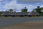
| Santa Lucia airport (MMSM) in Mexico |
|
Images related to this file:
File Description:
Santa Lucia airport is a new facility serving Mexico City, opened in 2022. The FSX scenery of this airport was built with the Airport Design Editor program, based on satellite images from Google Earth and on actual Jeppesen charts. The buildings are made with GMAX.
| Filename: | Santa_Lucia_airport_MMSM_in_Mexico.zip |
| License: | Freeware |
| Added: | 23rd December 2022, 21:34:40 |
| Downloads: | 733 |
| Author: | Winfried Orthmann |
| Size: | 5.49 MB |
| Category: Flight Simulator X - Scenery | |
| Santa Elena de Uairen, Venezuela (SVSE) |
|
Images related to this file:
File Description:
Located to south of Venezuela, to few kilometers from the border with Brazil.
The airport design, reflects the Pemon indigenous culture.
With photo-terrain scenery from satellite imagery of Google Earth.
Not compatible with versions prior to FSX.
This scenery requires SP1, SP2, or the Acceleration
expansion pack in order to be displayed correctly.
Also includes a friendly Auto-Install.
| Filename: | Santa_Elena_de_Uairen_Venezuela_SVSE.zip |
| License: | Freeware |
| Added: | 3rd August 2013, 17:34:22 |
| Downloads: | 1,411 |
| Author: | David Maldonado |
| Size: | 76.57 MB |
| Category: Flight Simulator X - Scenery | |
| SVCR |
|
File Description:
Jose Leonardo Chirino Airport (IATA: CZE, ICAO: SVCR), is an small airport in the coast town of Santa Ana de Coro, Venezuela
This file has the right coordinates, with the apron and characteristics of the airport, working jetways. The runways and runways were resized the gates placed on correct location.
| Filename: | SVCR.zip |
| License: | Freeware |
| Added: | 15th April 2011, 01:06:21 |
| Downloads: | 624 |
| Author: | Anwar Gonzalez |
| Size: | 5.09 KB |
| Category: Flight Simulator X - Scenery | |
| Santa Anna Orange County John Wayne Airport (KSNA) |
|
File Description:
Patch for the Shez's FS2004 John Wayne Airport scenery to make it work in FSX
| Filename: | Santa_Anna_Orange_County_John_Wayne_Airport_KSNA.zip |
| License: | Freeware |
| Added: | 22nd April 2009, 07:02:45 |
| Downloads: | 1,048 |
| Author: | P Nigel Grant/Shehryar Ansari |
| Size: | 515 KB |
© 2001-2026 AVSIM Online
All Rights Reserved
Privacy Policy |