
Where Flight Simulation Enthusiasts Gather from Around the World!
AVSIM Library - Search Results

| Category: Flight Simulator X - Scenery | |
| South America Mesh Scenery, MeshX_E7 |

|
File Description:
Mesh terrain scenery for the whole continental South America, based on SRTM 90m
dem geotiff files (at: ftp://ftp.glcf.umiacs.umd.edu/glcf/SRTM/Degree_Tiles/),
resampled to 76 meter of horizontal resolution (LOD 9). The new files have
improved the vertical resolution from 16m to 10m, resulting in more details
and accuracy over previous versions. There are 50 files, compatible with FS 9
and FS X, identified in a map by column letter and line number, covering the
contiguous countries and states. Boundaries: N = 22º 30' S; S = 28º 7.5' S;
E = 41º 15' W; W = 48º 45' W.
| Filename: | South_America_Mesh_Scenery_MeshX_E7.zip |
| License: | Freeware |
| Added: | 28th October 2006, 15:08:43 |
| Downloads: | 1,803 |
| Author: | Oséas Dourado and José Lôbo |
| Size: | 12.69 MB |
| Category: Flight Simulator X - Scenery | |
| South America Mesh Scenery, MeshX_C9 |
|
File Description:
Mesh terrain scenery for the whole continental South America, based on SRTM 90m
dem geotiff files (at: ftp://ftp.glcf.umiacs.umd.edu/glcf/SRTM/Degree_Tiles/),
resampled to 76 meter of horizontal resolution (LOD 9). The new files have
improved the vertical resolution from 16m to 10m, resulting in more details
and accuracy over previous versions. There are 50 files, compatible with FS 9
and FS X, identified in a map by column letter and line number, covering the
contiguous countries and states. Boundaries: N = 33º 45' S; S = 39º 22.5' S;
E = 56º 15' W; W = 63º 45' W.
| Filename: | South_America_Mesh_Scenery_MeshX_C9.zip |
| License: | Freeware |
| Added: | 29th October 2006, 03:13:28 |
| Downloads: | 3,582 |
| Author: | Oséas Dourado and José Lôbo |
| Size: | 19.76 MB |
| Category: Flight Simulator X - Scenery | |
| South America Mesh Scenery, MeshX_C10 |
|
File Description:
Mesh terrain scenery for the whole continental South America, based on SRTM 90m
dem geotiff files (at: ftp://ftp.glcf.umiacs.umd.edu/glcf/SRTM/Degree_Tiles/),
resampled to 76 meter of horizontal resolution (LOD 9). The new files have
improved the vertical resolution from 16m to 10m, resulting in more details
and accuracy over previous versions. There are 50 files, compatible with FS 9
and FS X, identified in a map by column letter and line number, covering the
contiguous countries and states. Boundaries: N = 39º 22.5' S; S = 45º 0' S;
E = 56º 15' W; W = 63º 45' W.
| Filename: | South_America_Mesh_Scenery_MeshX_C10.zip |
| License: | Freeware |
| Added: | 29th October 2006, 03:14:25 |
| Downloads: | 1,724 |
| Author: | Oséas Dourado and José Lôbo |
| Size: | 3.74 MB |
| Category: Flight Simulator X - Scenery | |
| South America Mesh Scenery, MeshX_A3 |
|
File Description:
Mesh terrain scenery for the whole continental South America, based on SRTM 90m
dem geotiff files (at: ftp://ftp.glcf.umiacs.umd.edu/glcf/SRTM/Degree_Tiles/),
resampled to 76 meter of horizontal resolution (LOD 9). The new files have
improved the vertical resolution from 16m to 10m, resulting in more details
and accuracy over previous versions. There are 50 files, compatible with FS 9
and FS X, identified in a map by column letter and line number, covering the
contiguous countries and states. Boundaries: N = 0º 0' S; S = 5º 37.5' S;
E = 71º 15' W; W = 78º 45' W.
| Filename: | South_America_Mesh_Scenery_MeshX_A3.zip |
| License: | Freeware |
| Added: | 29th October 2006, 15:43:18 |
| Downloads: | 1,980 |
| Author: | Oséas Dourado and José Lôbo |
| Size: | 37.85 MB |
| Category: Flight Simulator X - Scenery | |
| South America Mesh Scenery, MeshX_B11 |
|
File Description:
Mesh terrain scenery for the whole continental South America, based on SRTM 90m
dem geotiff files (at: ftp://ftp.glcf.umiacs.umd.edu/glcf/SRTM/Degree_Tiles/),
resampled to 76 meter of horizontal resolution (LOD 9). The new files have
improved the vertical resolution from 16m to 10m, resulting in more details
and accuracy over previous versions. There are 50 files, compatible with FS 9
and FS X, identified in a map by column letter and line number, covering the
contiguous countries and states. Boundaries: N = 45º 0' S; S = 50º 37.5' S;
E = 63º 45' W; W = 71º 15' W.
| Filename: | South_America_Mesh_Scenery_MeshX_B11.zip |
| License: | Freeware |
| Added: | 30th October 2006, 05:44:41 |
| Downloads: | 1,843 |
| Author: | Oséas Dourado, José Lôbo |
| Size: | 19.15 MB |
| Category: Flight Simulator X - Scenery | |
| South America Mesh Scenery, MeshX_A12 |
|
File Description:
Mesh terrain scenery for the whole continental South America, based on SRTM 90m
dem geotiff files (at: ftp://ftp.glcf.umiacs.umd.edu/glcf/SRTM/Degree_Tiles/),
resampled to 76 meter of horizontal resolution (LOD 9). The new files have
improved the vertical resolution from 16m to 10m, resulting in more details
and accuracy over previous versions. There are 50 files, compatible with FS 9
and FS X, identified in a map by column letter and line number, covering the
contiguous countries and states. Boundaries: N = 50º 37.5' S; S = 56º 15' S;
E = 71º 15' W; W = 78º 45' W.
| Filename: | South_America_Mesh_Scenery_MeshX_A12.zip |
| License: | Freeware |
| Added: | 30th October 2006, 05:45:01 |
| Downloads: | 1,955 |
| Author: | Oséas Dourado and José Lôbo |
| Size: | 13.36 MB |
| Category: Flight Simulator X - Scenery | |
| Whale Island Scenery: "Islands of the Bay of Plenty" |
|
File Description:
This scenery was created from a digital Orthorectified aerial mosaic owned by Environment Bay of Plenty (The Bay of Plenty Regional Council). The imagery has been de-sampled for use in Flight Simulator X and utilizes the default terrain mesh. The textures are intended for summer daylight flying only, although due to the sparse nature of White Islands' Evegetation, the Islands appearance remains relatively consistent throughout the year.
It includes autogen trees, a landable helicopter pad on the top of the Island, Radio masts, and the Department of Conservation (DOC) hut in the south western bay of the island.
| Filename: | Whale_Island_Scenery__Islands_of_the_Bay_of_Plenty.zip |
| License: | Freeware, limited distribution |
| Added: | 9th May 2007, 08:42:59 |
| Downloads: | 1,496 |
| Author: | Tim Barnes |
| Size: | 7.05 MB |
| Category: Flight Simulator X - Scenery | |
| Shahjalal International Airport (Zia) v1.1 |
|
Images related to this file:
File Description:
Updates and Fixed Issues:
**The "VGZR_ADEX_FSX.bgl" is re-edited;
**Some other minor bugs where fixed.
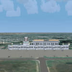
The biggest Shahjalal International Airport (Zia). Meticulously detailed and realistically depicted Flight Simulator X scenery for Shahjalal International Airport (Zia). Created with 3ds max from scratch, the scenery includes accurate buildings, hangars, parking bays, night texturing and illumination effects. The scenery contains variety of static aircraft and animations and photo real terrain texture. This a complete scenery for FSX. The ZIA_Shahjalal International Airport is the busiest airport in Bangladesh and provides access to 4,6 Mio. million passengers a year.
| Filename: | Shahjalal_International_Airport_Zia_v11.zip |
| License: | Freeware |
| Added: | 8th January 2012, 07:38:28 |
| Downloads: | 4,619 |
| Author: | Huseyin Buharali |
| Size: | 14.01 MB |
| Category: Flight Simulator X - Scenery | |
| Alaska Airfields Pack 2 - v1.0 |
|
Images related to this file:
File Description:
This is my second pack of yet another three airfields in Alaska that I have modified to look more like the real thing. The scenery is made of ready made library buildings and trees, no custom made objects, but it's a vast improvement over the stock FSX airfields. The three airfields are (6AK) Rainy Pass Airfield, (8KA) Tatitna Airfield and (5NI) Nikolai Airfield.
PLEASE NOTE: These scenerys are made with FSX Acceleration and Flight 1's Ultimate Alaska X installed. I don't know how they look or work without these add-ons.
| Filename: | Alaska_Airfields_Pack_2__v10.zip |
| License: | Freeware |
| Added: | 19th February 2012, 02:09:32 |
| Downloads: | 2,399 |
| Author: | Torbjorn Kuntze |
| Size: | 1.88 MB |
| Category: Flight Simulator X - Scenery | |
| South America Mesh Scenery, MeshX_D8 |
|
File Description:
Mesh terrain scenery for the whole continental South America, based on SRTM 90m
dem geotiff files (at: ftp://ftp.glcf.umiacs.umd.edu/glcf/SRTM/Degree_Tiles/),
resampled to 76 meter of horizontal resolution (LOD 9). The new files have
improved the vertical resolution from 16m to 10m, resulting in more details
and accuracy over previous versions. There are 50 files, compatible with FS 9
and FS X, identified in a map by column letter and line number, covering the
contiguous countries and states. Boundaries: N = 28º 7.5' S; S = 33º 45' S;
E = 48º 45' W; W = 56º 15' W;
| Filename: | South_America_Mesh_Scenery_MeshX_D8.zip |
| License: | Freeware |
| Added: | 28th October 2006, 15:07:00 |
| Downloads: | 1,921 |
| Author: | Oséas Dourado and José Lôbo |
| Size: | 28.66 MB |
© 2001-2026 AVSIM Online
All Rights Reserved
Privacy Policy |