
Where Flight Simulation Enthusiasts Gather from Around the World!
AVSIM Library - Search Results

| Category: Flight Simulator X - Scenery | |
| Victoria, Canada including US Southern Gulf Islands and San Juan Islands - Part 2 of 2 |

|
Images related to this file:
File Description:
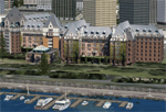
FSX-only version of Victoria, Canada area scenery including the Southern Gulf Islands and the San Juan Islands of the US. Includes automated installer and configurator by Scot Fraser.
Features:
-accurate shorelines, lakes and streams;
-landclass;
-FSX multi-LOD mesh with 10m maximum resolution;
-complete road network with moving traffic;
-railroads;
-utility corridors;
-marinas and ferry terminals;
-many static boats, including a custom model of the Canada Coast Guard ship Sir Wilfred Laurier;
-detailed models of major buildings and the Ogden Point Terminal;
-many bridges;
-nearly 300 marine lights; and corrected antennae locations.
Facilities include Don Grovestine's famous CYYJ (Victoria International Airport); 12 other Canadian land-based airports: Butler Field, Duncan (CAM3), Gaines, Hastings, Hudson Island, James Island, Thomas, Village Bay, Raven Field (CML2), Saltspring, Sidney Island, Whiskey Point; 20 US airports Blakely (38WA), Burden (61WA), Center Island (79WA), Clam Harbor (WA35), Crane Island, Decatur Shores (WN07), Decatur-Jones (WA18), Waldronaire (90WA), Orcas Island (KORS), Friday Harbour (KFHR), Lopez Island (S31), Pile Point, Roche Harbor (WA09), Shaw Island, Stuart Island Airpark (7WA5), Stuart Island West (2WA3), Wilding (6WA5), Windsock (4WA4); 12 floatplane facilities: Bedwell (CAB3), Fisherman's Bay (WA81), Friday Harbor (W33), Ganges (CAX6), Maple Bay, Mayne (CAW7), Port Washington (CAP8), Roche Harbor (W39), Rosario (W49), Shawnigan Lake (CAV8), Victoria Harbour (CYWH), Victoria International (CAP5) and Westsound, Orcas (WA83) - many with AI traffic; 9 heliports: Ganges (CAL7), Mayne (CBF5), Camel Point (CBF7), Jubilee (CBK8), Victoria General (CBW7) Madrona Bay (CBW9), Shoal Point (CBZ7), Mount Belcher (CMBH).
AI models include the DHC-2 floatplane in local liveries, a cruise ship model (by Mitsuya Hamaguchi) and two repaints, pilot boat, and small boats (by Larry Silsbee).
Ultimate Terrain X compatible (not required). Users of Vancouver+ for FSX will also get additional cruise ship traffic and additional floatplane and helicopter traffic. Full documentation. By Don Grovestine, Jon Patch and Holger Sandmann. Many other contributors: see documentation. Part 2 of 2 - you also need file vicenh7a.zip
| Filename: | Victoria_Canada_including_US_Southern_Gulf_Islands.zip |
| License: | Check within download |
| Added: | 29th January 2010, 21:21:49 |
| Downloads: | 23,163 |
| Author: | Don Grovestine, Jon Patch and Holger Sandmann |
| Size: | 59.08 MB |
| Category: Flight Simulator X - Scenery | |
| KGFL - Floyd Bennett Memorial - Glens Falls, New York v3.0 |
|
Images related to this file:
File Description:
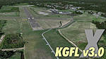
KGFL - Glens Falls, Floyd Bennett Memorial v3.0, located in the foothills of the Adirondack Mountains in upstate NY USA, this facility is owned by Warren County and run by RichAir. Although it has a 5000 ft main rwy, KGFL is a Non-controlled airfield catering to small engine a/c up to a few private jet daily traffic serving 'The Northcountry' New York. KGFL recently received several upgrades including 4 new GA hangars large enough to accommodate the needs of business jets. All Objects fully designed and completely redone in GMAX using high resolution custom photo-real textures. Complete rebuild from the ground up for FSX since v2.2 for Fs9. Also includes new ADE file, more accurate airport grounds perimeter, satellite photo-real grounds, custom taxiways, 3D taxi-signs and taxi lights, area roads, animated hangar doors, and near area landclass. No AI traffic tracks included with this release, but ADE designed to support several AI. FSX Acceleration required.
| Filename: | KGFL__Floyd_Bennett_Memorial__Glens_Falls_New_York.zip |
| License: | Freeware, limited distribution |
| Added: | 5th February 2013, 06:14:14 |
| Downloads: | 2,294 |
| Author: | EdGeneer Cox |
| Size: | 143.72 MB |
| Category: Flight Simulator X - Scenery | |
| Dieuze - Gueblange V2 |
|
Images related to this file:
File Description:
This scenery depicts Dieuze-Gueblange aerodrome located in the north east of France. It is a very accurate rendition of this aerodrome made with photoreal textures for the ground and the objects. The ground is covered with volumetric grass. I have modelled an animated sock that indicates the wind direction and velocity. To see this windsock, Sode (Sim Objects Display Engine) module must be installed (module availabale here : http://sode.12bpilot.ch/?page_id=9). A user manual (pdf) is included.
The windsock library may be used in your own sceneries. If you share a scenery using this library, you must add the BJP_SOCKS folder without any modification in order to avoid duplicate files. Please include my name in any of your included documents. This new release is now compatible with a landclass environment: snowy ground and trees in the hard winter (from the first day of december to the last day of january). Please read the specific enclosed manual.
| Filename: | Dieuze__Gueblange_V2.zip |
| License: | Freeware, limited distribution |
| Added: | 1st February 2015, 23:14:45 |
| Downloads: | 1,451 |
| Author: | Jacques-Paul Bollard |
| Size: | 21.98 MB |
| Category: Flight Simulator X - Scenery | |
| "IKAROS" Airport |
|
Images related to this file:
File Description:
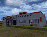
"IKAROS" Airport for FSX SP2
"IKAROS" airport is a private strip, 105km NW of Athens located in the Kopaida plains between the towns of Aliartos, Kastro and Orchomenos and west of Yliki lake. It is a pure general aviation field and the small terminal offers some services and facilities for the convenience of visiting aviators and passengers. The scenery includes a region and landclass bgl for a large area of the Kopaida plains around the airport. Most objects used are custom objects designed from pictures of the real thing. Moving road traffic as well as custom GA traffic are also included.
Note: If you downloaded this file before 10th of March 2011 21:30 GMT then you may wish to re-download. The original file had the hold short lines on the taxiway the wrong way around. The new file will work in your install by just overwriting the old one.
| Filename: | IKAROS_Airport.zip |
| License: | Freeware |
| Added: | 10th March 2011, 22:20:44 |
| Downloads: | 2,346 |
| Author: | Vassilios Dimoulas |
| Size: | 8.96 MB |
| Category: Flight Simulator X - Scenery | |
| Punta Gorda, FL- Charlotte County Airport (KPGD) |
|
Images related to this file:
File Description:
What appears to be a nearly "dead" airport in FSX is brought to life with scenery objects and air traffic. Generic floating buildings have been replaced with custom and library objects. Landclass changes, roads, rework of runways, taxiways and aprons, placement of library objects and a library of new airport buildings are included. Scenery in this package is based on Virtual Earth (Bing) and Google Earth imagery.
Even though the airport doesn't have a control tower and no gate parking is included in FSX, it does have a terminal and airline traffic in real life. Also, no GA traffic has been observed in FSX other than an occasional aircraft doing a couple of touch-and-gos and moving on. The World of AI traffic file for Allegiant Airlines does not include flights to this airport, so a traffic file is included adding the Allegiant flights as well as some GA flights. The World of AI package is required for the airline flights to display.
| Filename: | Punta_Gorda_FL_Charlotte_County_Airport_KPGD.zip |
| License: | Freeware |
| Added: | 3rd January 2011, 03:06:31 |
| Downloads: | 1,712 |
| Author: | Art Poole |
| Size: | 1.47 MB |
| Category: Flight Simulator X - Scenery | |
| South America Mesh Scenery, MeshX_E4 |
|
File Description:
Mesh terrain scenery for the whole continental South America, based on SRTM 90m
dem geotiff files (at: ftp://ftp.glcf.umiacs.umd.edu/glcf/SRTM/Degree_Tiles/),
resampled to 76 meter of horizontal resolution (LOD 9). The new files have
improved the vertical resolution from 16m to 10m, resulting in more details
and accuracy over previous versions. There are 50 files, compatible with FS 9
and FS X, identified in a map by column letter and line number, covering the
contiguous countries and states. Boundaries: N = 5º 37.5' S; S = 11º 15' S;
E = 41º 15' W; W = 48º 45' W;
| Filename: | South_America_Mesh_Scenery_MeshX_E4.zip |
| License: | Freeware |
| Added: | 28th October 2006, 05:55:47 |
| Downloads: | 1,527 |
| Author: | Oséas Dourado and José Lôbo |
| Size: | 38.91 MB |
| Category: Flight Simulator X - Scenery | |
| South America Mesh Scenery, MeshX_F4 |
|
File Description:
Mesh terrain scenery for the whole continental South America, based on SRTM 90m
dem geotiff files (at: ftp://ftp.glcf.umiacs.umd.edu/glcf/SRTM/Degree_Tiles/),
resampled to 76 meter of horizontal resolution (LOD 9). The new files have
improved the vertical resolution from 16m to 10m, resulting in more details
and accuracy over previous versions. There are 50 files, compatible with FS 9
and FS X, identified in a map by column letter and line number, covering the
contiguous countries and states. Boundaries: N = 5º 37.5' S; S = 11º 15' S;
W = 41º 15' W; E = 33º 45' W;
| Filename: | South_America_Mesh_Scenery_MeshX_F4.zip |
| License: | Freeware |
| Added: | 28th October 2006, 05:54:09 |
| Downloads: | 1,524 |
| Author: | Oséas Dourado and José Lôbo |
| Size: | 32.14 MB |
| Category: Flight Simulator X - Scenery | |
| EKSP Skrydstrup version 1.2 update |
|
Images related to this file:
File Description:
EKSP Skrydstrup version 1.2 update, for Microsoft Flight Simulator X/Lockheed Martin Prepar3D (all versions)
Maintenance update, including compatibility fixes for LM Prepar3D version 4.
Changelog:
---------
Updated tower frequency to reflect real life changes: 118.275 MHz
Added ATIS as currently in use: 113.900 MHz
Straightened taxiway N.
Added aircraft parking spot for very large aircraft (i.e. An-225.).
Updated service vehicle parking.
Corrected wayward perimeter fence in the NW corner.
Excluded stock airport background polygon.
Moved F-16 gate guard textures to the main "Texture" folder.
Optimized light effects for minimal FPS impact.
Ramp lighting is now dynamic in P3D version 4.
| Filename: | EKSP_Skrydstrup_version_12_update.zip |
| License: | Freeware |
| Added: | 8th June 2017, 03:24:57 |
| Downloads: | 755 |
| Author: | Jens Peter Pedersen |
| Size: | 2.26 MB |
| Category: Flight Simulator X - Scenery | |
| South America Mesh Scenery, MeshX_F6 |
|
File Description:
Mesh terrain scenery for the whole continental South America, based on SRTM 90m
dem geotiff files (at: ftp://ftp.glcf.umiacs.umd.edu/glcf/SRTM/Degree_Tiles/),
resampled to 76 meter of horizontal resolution (LOD 9). The new files have
improved the vertical resolution from 16m to 10m, resulting in more details
and accuracy over previous versions. There are 50 files, compatible with FS 9
and FS X, identified in a map by column letter and line number, covering the
contiguous countries and states. Boundaries: N = 16º 52.5' S; S = 22º 30' S;
E = 33º 45' W; W = 41º 15' W;
| Filename: | South_America_Mesh_Scenery_MeshX_F6.zip |
| License: | Freeware |
| Added: | 28th October 2006, 15:07:29 |
| Downloads: | 1,510 |
| Author: | Oséas Dourado and José Lôbo |
| Size: | 9.8 MB |
| Category: Flight Simulator X - Scenery | |
| South America Mesh Scenery, MeshX_D9 |
|
File Description:
Mesh terrain scenery for the whole continental South America, based on SRTM 90m
dem geotiff files (at: ftp://ftp.glcf.umiacs.umd.edu/glcf/SRTM/Degree_Tiles/),
resampled to 76 meter of horizontal resolution (LOD 9). The new files have
improved the vertical resolution from 16m to 10m, resulting in more details
and accuracy over previous versions. There are 50 files, compatible with FS 9
and FS X, identified in a map by column letter and line number, covering the
contiguous countries and states. Boundaries: N = 33º 45' S; S = 39º 22.5' S;
E = 48º 45' W; W = 56º 15' W.
| Filename: | South_America_Mesh_Scenery_MeshX_D9.zip |
| License: | Freeware |
| Added: | 28th October 2006, 15:08:16 |
| Downloads: | 1,877 |
| Author: | Oséas Dourado and José Lôbo |
| Size: | 4.69 MB |
© 2001-2026 AVSIM Online
All Rights Reserved
Privacy Policy |