
Where Flight Simulation Enthusiasts Gather from Around the World!
AVSIM Library - Search Results

| Category: Flight Simulator X - Scenery | |
| Lake Kipawa - Quebec bush scenery |

|
File Description:
This scenery is fictitious and created for the pleasure of all. All the objects are already included in FSX and no other library was used. Seaplane base Kipawa is located on the North side of the lake, and this place is meant to be a site of free time for small boats. It can also be a refueling place for seaplanes. Lake Kipawa is situated at the far South West coast of Quebec, in the region of Abitibi-Temiscamingue. Must have before installing the Aerovirtuel bush flying sceneries:
1-Quebec Elevation 38m (LOD10) Gilles Gauthier sur http://avsim.com/ 5 files.
2-Quebec Scenery - Lakes and Rivers (1/5) http://avsim.com/ 5 files and one fix
3-Quebec Scenery - Addition of Roads http://avsim.com/
| Filename: | kipawa.zip |
| License: | Freeware, limited distribution |
| Added: | 10th November 2007, 22:15:04 |
| Downloads: | 836 |
| Author: | Denis Dupuis |
| Size: | 1.01 MB |
| Category: Flight Simulator X - Scenery | |
| JZZ - Koliganek Airport - Alaska, USA |
|
Images related to this file:
File Description:
Koliganek Airport (IATA: KGK, ICAO: PAJZ, FAA LID: JZZ) is a state-owned, public-use airport located one nautical mile (1.85 km) east of the central business district of Koliganek,in the Dillingham Census Area of the U.S. state of Alaska. Scheduled airline service to Dillingham Airport is provided by Peninsula Airways (PenAir).The airport opened in 1997.
Increased length of runway 9/27 from 3,000 feet to 3,300 feet.Added runway 17/35 (3,300 feet and 75 feet wide). Changes were based on 2011 construction plans.
Created with Airport Design Editor 9x by ScruffyDuck Software using current FAA documentation and Google Earth measurements, this package offers a replacement for FSX's stock airport. All these enhancements are as close to the real airport as I can get with stock library objects and custom buildings.
| Filename: | jzzairport.zip |
| License: | Freeware |
| Added: | 25th December 2014, 01:15:29 |
| Downloads: | 586 |
| Author: | Wayne Roberts |
| Size: | 230 KB |
| Category: Flight Simulator X - Scenery | |
| KMFV - Accomack County Airport - Melfa, Virginia, USA |
|
Images related to this file:
File Description:
Accomack County Airport (IATA: MFV, ICAO: KMFV) is a county-owned public-use airport located 1 mile (1.6 km) west of the central business district of Melfa. The airport was built by the United States Army Air Forces about 1942, and was known as Melfa Flight Strip. It was an emergency landing airfield for military aircraft on training flights. It was closed after World War II, and was turned over for local government use by the War Assets Administration (WAA).
This is a complete re-work of the airport with added taxiways, parking and custom buildings. Created with Airport Design Editor by ScruffyDuck Software using current FAA documentation and Google Earth measurements, this package offers a replacement for FSX's stock airport. All these enhancements are as close to the real airport as I can get with stock library objects and custom buildings.
| Filename: | kmfvairport.zip |
| License: | Freeware |
| Added: | 16th February 2015, 11:56:40 |
| Downloads: | 419 |
| Author: | Wayne Roberts |
| Size: | 324 KB |
| Category: Flight Simulator X - Scenery | |
| KMKJ - Mountain Empire Airport - Virginia, USA |
|
Images related to this file:
File Description:
Mountain Empire Airport (ICAO: KMKJ, FAA LID: MKJ) is a public use airport in Smyth County, Virginia, United States.[1] It located nine nautical miles (10 mi, 17 km) northeast of the central business district of Marion (in Smyth County)[1] and 13 nautical miles (15 mi, 24 km) west of Wytheville (in Wythe County).[2] The airport is situated between Interstate 81 and U.S. Route 11 (Lee Highway), near Groseclose. It is owned by Smyth Wythe Airport Commission.
This is a complete re-work of the airport. Added taxiway, additional parking aprons and custom buildings.
Created with Airport Design Editor by ScruffyDuck Software using current FAA documentation and Google Earth measurements, this package offers a replacement for FSX's stock airport. All these enhancements are as close to the real airport as I can get with stock library objects and custom buildings.
| Filename: | KMKJ__Mountain_Empire_Airport__Virginia_USA.zip |
| License: | Freeware |
| Added: | 25th January 2015, 15:55:52 |
| Downloads: | 306 |
| Author: | Wayne Roberts |
| Size: | 339.5 KB |
| Category: Flight Simulator X - Scenery | |
| Descobrir Portugal X |
|
File Description:
This is the first version of DESCOBRIR PORTUGAL for FSX.
My intention is to create a new global scenery for the Portuguese territory, with new coast lines, roads, railroads, landclass, airports and local landmarks, lighthouses, bridges, castels and many other improvements.
In this first attempt for FSX:
Complete Scenery for: LPMU Mogadouro, LPCS Cascais Tires, LPEV Évora, LPPM Portimão.
Incomplete scenery for: LPBR Braga, LPBG Bragança, LPPR Oporto Intl, LPHR Horta; LPCE Cerval.
Realistic afcads for: LPVL Maia, LPVR Vila Real, LPMR Monte Real AB, LPSR Santarem, LPAT Almoster, LPMX Machede, LPLG Lagos, LPTV Tavira, LPAP Armação de Pera, LPPV Praia Verde, LPPI Pico.
150 Kms. Of replaced coastlines.
6200 Kms2 of realistic landcass, roads, Rivers, landmarks, etc.
Any comments and suggestions are wellcome.
ONLY for flight Simulator X.
| Filename: | dpx02.zip |
| License: | Freeware |
| Added: | 24th February 2007, 22:52:09 |
| Downloads: | 13,229 |
| Author: | José Maia |
| Size: | 24.55 MB |
| Category: Flight Simulator X - Scenery | |
| Yeu island - LFEY |
|
Images related to this file:
File Description:

The island of Yeu (LFEY) is located in the west of France, in the south-west of Nantes. Its main runway is located on the wild coast, near the great lighthouse.
It is made up of :
- A new mesh based ASTER compiled in LOD11 and a very local mesh for the airport, compiled in LOD13 to get a good compatibility with the specific payware meshes.
- Photorealistic texture at 0.5 m/pixel based on aerial photography.
- The airfield and runway. The runway is flat, allowing to preserve the AI traffic. The grass strip is modeled with its relief. There is therefore no AI traffic on the grass strip.
- The port of Port-Joinville and several notable buildings made with Gmax (churches, chapel, castle, fort, ruins, beacons, etc)
- Generic or custom objects created with Gmax (boats, buildings).
| Filename: | yeu_lfey_fsx_light.zip |
| License: | Freeware |
| Added: | 29th December 2012, 04:03:47 |
| Downloads: | 1,706 |
| Author: | marc guitteny |
| Size: | 217.84 MB |
| Category: Flight Simulator X - Scenery | |
| Clark International Airport RPLC - CRK |
|
Images related to this file:
File Description:
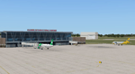
FSX scenery for Clark International Airport in Angeles city, Papamga Province , Philippines.
Clark International Airport, formerly the Diosdado Macapagal International Airport (IATA: CRK, ICAO: RPLC), is an airport that is an international gateway to the Philippines within Clark Freeport Zone located 80KM northwest of Manila. The airport is located along the border between the cities of Angeles and Mabalacat in the province of Pampanga and is accessible through the Subic-Clark-Tarlac Expressway, which is connected to the North Luzon Expressway.
Clark serves the general vicinity of central and northern Luzon. The name is derived from the former American Clark Air Force Base which was the largest overseas base of the United States Air Force until it was closed in 1991 and handed over to the Government of the Philippines.
Airlines serving CRK include Air Asia, Asiana, Cebu Pacific, Dragonair, Emirates, Jin Air, Qatar Airways, Tigerair, Fedex and Ups
| Filename: | clark_airport.zip |
| License: | Freeware, limited distribution |
| Added: | 24th September 2016, 02:43:49 |
| Downloads: | 2,976 |
| Author: | Yann Martineau |
| Size: | 508 KB |
| Category: Flight Simulator X - Scenery | |
| LFMA - Aix les Milles |
|
File Description:
Welcome to Aix Les Milles Airport.
Situated in the south coast of France, only few miles North East of Marignane (Marseille Provence - LFML). This is a great option for all G.A aircrafts to visit as well as Helicopters/Medical with their own base and it's even large enough to welcome the famous Alphajets from the "Patrouille de France".:)
The airport is used by those who wants to spend a great week end in the very well known city called Aix En provence and discover the beauty of Provence.
I have enhanced the entire airport with all buildings, proper taxi marking of aprons, taxisigns, Glider area/parking lot, Heli area including the medical one, replaced the tower at its own place, a military parking for the Alpha jets (Novembre West apron) and added...the LFMA VFR chart!!!
Enjoy!
| Filename: | LFMA__Aix_les_Milles.zip |
| License: | Freeware |
| Added: | 1st May 2009, 00:14:01 |
| Downloads: | 1,970 |
| Author: | Daniel Louvet |
| Size: | 1.29 MB |
| Category: Flight Simulator X - Scenery | |
| CYYJ (2017) for FS9, FSX and P3D |
|
Images related to this file:
File Description:

CYYJ (2017), Version 7, is a major upgrade to CYYJ (2014). It portrays the Victoria (British Columbia, Canada) International Airport (CYYJ), aviation museum, Pat Bay floatplane base (CAP5) and Coast Guard station, and nearby industrial park as they appeared in early 2017 - as well as a host of static aircraft. It is fully compatible with Victoria+ (both FS2004 And FSX versions), Ultimate Terrain Canada/Alaska for FS2004 and Ultimate Terrain X - Canada for FSX, ORBX's FTX NA Blue and other FS9 road and shoreline upgrades for the area. CYYJ (2017) includes aircraft and traffic files for a realistic AI scenario other than scheduled airline operations. (Use BC Regional AI - also available from this file library - for scheduled traffic).
Version 7 adds all the recent major new construction and apron expansion at CYYJ, and includes a greater level of detail in many areas.
| Filename: | CYYJ_2017__for_FS9_FSX_and_P3D.zip |
| License: | Freeware, limited distribution |
| Added: | 24th May 2017, 18:30:48 |
| Downloads: | 5,931 |
| Author: | Don Grovestine |
| Size: | 118.7 MB |
| Category: Flight Simulator X - Scenery | |
| KVC - King Cove Airport - Alaska, USA |
|
Images related to this file:
File Description:
King Cove Airport (IATA: KVC, ICAO: PAVC, FAA LID: KVC) is a state-owned public-use airport located four miles (6 km) northeast of the central business district of King Cove, a city in the Aleutians East Borough of the U.S. state of Alaska.
King Cove Airport has one runway (7/25) with a gravel surface measuring 3,500 x 75 ft. (1,067 x 23 m). For the 12-month period ending December 31, 2005, the airport had 1,030 aircraft operations: 71% air taxi and 29% general aviation.
Changes: Increased parking apron and turn arounds at both ends of the runway. Also added additional parking and custom models. Changes were based on 2014 construction plans.Created with Airport Design Editor 9x by ScruffyDuck Software using current FAA documentation and Google Earth measurements, this package offers a replacement for FSX's stock airport. All these enhancements are as close to the real airport as I can get with stock library objects and custom buildings.
| Filename: | kvcairport.zip |
| License: | Freeware |
| Added: | 20th December 2014, 00:02:03 |
| Downloads: | 826 |
| Author: | Wayne Roberts |
| Size: | 458 KB |
© 2001-2025 AVSIM Online
All Rights Reserved