
Where Flight Simulation Enthusiasts Gather from Around the World!
AVSIM Library - Search Results

| Category: Flight Simulator X - Scenery | |
| SLET - El Trompillo Airport - Santa Cruz de la Sierra, Bolivia |

|
File Description:
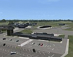
El Trompillo Airport (IATA: SRZ, ICAO: SLET) is located in the south part of Santa Cruz de la Sierra, Bolivia, about 2 km (1.25 miles) away from the central plaza. Airport type:(Public / Military).
After a series of improvements, in June 3, 2014 Airport regained its status as an international airport by converting to Santa Cruz de la Sierra in Bolivia the only city with two international airports, international airport suitable as retention and/or support times of high demand in the Viru Viru Airport (ICAO: SLVR) can not supply completely.
The airport operates 24 hours and resides at an elevation of 1,371 ft (418 m) above mean sea level. Have one runway designated 15/33 with an asphalt surface measuring 8,967 by 114.82 ft (2,733 m by 35 m), El Trompillo Tunnel for vehicles, passes under the runway and connects the 4th ring (considered the most important highway in the city).
Compatible with both FSX and P3D.
| Filename: | SLET__El_Trompillo_Airport__Santa_Cruz_de_la_Sierr.zip |
| License: | Freeware |
| Added: | 19th November 2015, 09:49:14 |
| Downloads: | 1,832 |
| Author: | Marcos A. Rivas Torrez |
| Size: | 16.68 MB |
| Category: Flight Simulator X - Scenery | |
| NY3C - Taylor Field - Hammondsport, New York (Fictional ICAO) |
|
Images related to this file:
File Description:
The airport named Taylor Field (on 1970's sectional charts) is a small 1800' strip not shown in the stock FSX list of airports. There is no ICAO code or other designator I could find with extensive research. I used my own code of NY3C.
This is a part reality part historic scenery as it represents the modern day airport, the Glenn Curtiss Museum, and adjacent to the Airport a facsimile of the original horse racetrack that was used by Glenn Curtiss to fly his June Bug on July 4th 1908. It is a close As I can determine to the original spot using archival photos and conversations with the Director of the Curtiss Museum, Traff Doherty. Extensive use of new land class is also employed to give a better representation of the geographic area.
This will work with FSX stock scenery, but is designed with UTX (Flight One Software) in mind. It will work with ORBX Global and Global Vector as well. With these latter two there may be some missing roads but it won't affect the scenery.
| Filename: | NY3C__Taylor_Field__Hammondsport_New_York_Fictiona.zip |
| License: | Freeware |
| Added: | 24th July 2014, 07:46:29 |
| Downloads: | 343 |
| Author: | Jon Davidson |
| Size: | 9.79 MB |
| Category: Flight Simulator X - Scenery | |
| Odense Airport (EKOD), Funen, Denmark |
|
Images related to this file:
File Description:
Odense Lufthavn (Odense Airport) is situated close the village of Beldringe, a few km north of Odense, the main city on the island of Funen, Denmark. Like several other Danish airports it was established as an airbase by the Germans during World War II. It was taken over by the Danish state after the war and owned by the state until 1998, at which time it was taken over by a consortium of local authorities, including the city of Odense.
Since the opening of the Great Belt Lin in 1997 there has been no regular passenger flights, apart from some charter traffic during the summer season. But there is a lot of traffic with one- and two-motor craft (including rotor craft) due to the many companies based in the airport.
The package is a complete scenery of the airport, including a few buildings around it. It includes approach lights, runway lights, taxiway lights and light on the apron, the car parking area and the surrounding roads. A traffic file with the (limited) charter traffic of the airport is also included.
| Filename: | Odense_Airport_EKOD_Funen_Denmark.zip |
| License: | Freeware, limited distribution |
| Added: | 31st October 2009, 10:29:34 |
| Downloads: | 3,728 |
| Author: | Peter H. Poulsen |
| Size: | 13.63 MB |
| Category: Flight Simulator X - Scenery | |
| ENHV - Honningsvag-Valan - Honningsvag, Norway |
|
Images related to this file:
File Description:
ENHV is the most northern airport in Europe (self-promotion of the airport). It it situated on a promontory 46 feet above the sea a few miles southeast of the Nordkap.
This scenery is not a stand-alone-scenery. It is an update of the Airports of Norway (AoN) where ENHV is already included. So AoN has to be installed first to see the buildings and the objects on this airport.
In addition the Nordkap is included with the rock, the museum and the viewing point.
AON you can download here:
http://www.flightsimnorway.com/addons/default.php?funct=dl&pack=aon
Also recommended is to install are the corresponding Photo sceneries AoN Phatopack 1 + 2:
http://www.flightsimnorway.com/addons/default.php?funct=dl&pack=aon
There are some errors corrected In ENHV that occur in the AoN:
1. The altitude is adjusted to the correct height of 46 feet.
2. The sea is where it should be.
3. The land classes are partially adjusted.
4. The town of Honningsvag is involved.
5. The Northern Cape is included, but can be installed separately.
| Filename: | ENHV__HonningsvagValan__Honningsvag_Norway.zip |
| License: | Freeware |
| Added: | 19th October 2015, 18:54:47 |
| Downloads: | 1,920 |
| Author: | Wolfgang Allers |
| Size: | 131.64 MB |
| Category: Flight Simulator X - Scenery | |
| Active ILS, VHHX (Hong Kong Kai Tak Airport) |
|
File Description:
This FSX Airport is more then just an enhanced style Airport. As most know the Approach and Final (VMC) for AI Traffic in FSX is a straight in type landing and does not always consider real world approaches. This is due to the way that the coding is written in FSX and it puts limits on IFR arriving aircraft. At certain airports the AI Traffic will fly directly through a mountain once it is established on Final for a runway. What you will see with my files is a different type approach used for both the way I control AI and User Airplane Traffic in FSX. My AI Aircraft Approach coding system for FSX uses a visual offset approach so AI Traffic does not fly through the mountains but flys the IGS/LDA 13 approach to the Checkerboard. Try your skill flying a Large Heavy Airplane vectored by ATC onto the approach course of the IGS/LDA 13 approach to Kai Tak. Read the text file for all the enhancements added to the FSX VHHX Airport along with a full understanding of how the new Approaches work *** Full set of Freeware Approach Charts included ***
| Filename: | Active_ILS_VHHX_Hong_Kong_Kai_Tak_Airport.zip |
| License: | Freeware, limited distribution |
| Added: | 19th September 2007, 11:57:46 |
| Downloads: | 27,444 |
| Author: | Jim Vile |
| Size: | 3.61 MB |
| Category: Flight Simulator X - Scenery | |
| 2016 Kigali Intl (HRYR) Rwanda |
|
Images related to this file:
File Description:
This sequel to the 2009 Kigali Intl (HRYR) Rwanda scenery (by Jacques Botha and Frits Beyer) brings it up to date with the current layout and enables full compliance with FTX Global/Vector and FSX. Buildings are added and adjusted to their real-world locations, and the new taxiway and south apron are added according to the May 2016 satellite imagery. In addition to real-world gate locations, custom apron markings are added along with apron lighting. The landclass around Kigali is also updated, and SRTMGL1 (30m) mesh is included. This scenery can be complemented by the Goma (FZNA) and Gisenyi (HRYG) scenery (FSX_FZNA-HRYG_CS.zip), and GA flightplans are included to supplement the commercial traffic at Kigali and provide more activity at FZNA and HRYG.
Updates were created or rebuilt in a manner which carefully aligns airport data with current satellite imagery. Scenery was created using Airport Design Editor X v1.70.6042, SBuilderX 3.13, and the FSX Object Placement Tool. Scenery objects were added and modified from stock FSX scenery to resemble as closely as possible the actual airports. The FSX apron lights included are from the set created by Jim Dhaenens.
| Filename: | 2016_Kigali_Intl_HRYR_Rwanda.zip |
| License: | Freeware |
| Added: | 4th August 2016, 21:10:09 |
| Downloads: | 3,379 |
| Author: | Carlyle Sharpe, Jacques Botha, and Frits Beyer |
| Size: | 17.12 MB |
| Category: Flight Simulator X - Scenery | |
| LGKF Kefallinia / Cephalonia International Airport, Greece |
|
Images related to this file:
File Description:
LGKF Kefallinia Greece
The island of Kefalonia lies on the west coast of Greece. The nearest airports are LGZA Zakinthos, LGKR Kerkira, and LGPZ Preveza. During the tourist season the island is a very popular destination for flights from Frankfurt, Berlin, Gatwick, Rome and many others.
This scenery has been designed to sit on top of Yiannis Dermitzakis's file - grcoastlines.zip, available here on Avsim. I would also highly recommend Angelo Tassoglou's photoreal scenery called ionianislands.zip, also available here on Avsim.
The scenery has been created using real photographs where possible and has been repositioned in line with satellite imagery. It features many objects painted with Hellenic features and Mediterranean vegetation. It also includes animated flags, windsocks, vehicles, aircrew and road traffic around the airport. Full night lighting is included together with wash lighting of the apron and carparks. The scenery has been sub-divided so that each part can be switched on or off according to user preference. Traffic files are based on real schedules effective to 2013. The scenery has been designed for, and tested with FSXA only. Full installation instructions, settings, hints and tips are included.
Please enjoy and I hope you like my scenery as much as I enjoyed building it.
| Filename: | LGKF_Kefallinia__Cephalonia_International_Airport_.zip |
| License: | Freeware, limited distribution |
| Added: | 23rd December 2012, 23:10:32 |
| Downloads: | 23,226 |
| Author: | George Keogh |
| Size: | 60.33 MB |
| Category: Flight Simulator X - Scenery | |
| FSX An Idaho Mountain Flying adventure |
|
Images related to this file:
File Description:

Welcome to the Heart of Idaho!
The mountain country has to be seen to be believed. As one who grew up exploring
this part of the US I had the fortunate opportunity to do things that most just dream about. Who wouldn't want to
swim in hot-spring fed lakes, or pools? Idaho has more hot springs than any other state. Have you ever climbed up
to a pass at 10,000 feet? And then looked down at those who chose not to climb 1500 feet below, looked left at your
brother, and then looked over the pass at the mountain basin that begged to be explored. I did these things 58 years
ago. You can do it tomorrow if you want to.
This FSX adventure will take you to many places I have visited. It will also take you to places that I have not yet
visited. Some of the strips are difficult to get into. That is typical of mountain flying. Some are reasonable.
Your flying skills will be tested as you figure out the best approach.
The simulation consists of 19 airports in Central Idaho. Twelve existing strips have had improvements consisting of
strip surface improvements to allow all-season activity, and some eye candy. Seven new air facilities have been
added to the area.
| Filename: | FSX_An_Idaho_Mountain_Flying_adventure.zip |
| License: | Freeware, limited distribution |
| Added: | 29th January 2019, 18:38:19 |
| Downloads: | 189 |
| Author: | Brett Delana |
| Size: | 3.94 MB |
| Category: Flight Simulator X - Scenery | |
| Santa Cruz de la Sierra - Bolivia |
|
File Description:
Scenery Photoreal: Santa Cruz de la Sierra, Bolivia
Santa Cruz de la Sierra: (English: Holy Cross of the Mountain Range), commonly known as Santa Cruz, is the
capital of the Santa Cruz department in eastern Bolivia (17 45', South, 63 14', West)at 416 m above sea level.
The city of Santa Cruz is located not far from the easternmost extent of the Andes Mountains and they are
visible from some parts of the city its Situated too on the Pirai River.
The city of Santa Cruz and its metropolitan area are home to over 70% of the population of the department and
it is one of the fastest-growing cities in the world.
Airports: (NOT included in this package, just Scenery Photoreal of the city)
Viru Viru International Airport (IATA: VVI, ICAO: SLVR) in Santa Cruz de la Sierra, Bolivia is Bolivia's largest
international airport. Viru Viru handles domestic, regional, and international flights from Bolivia to
North America, South America and Europe and is the hub for Bolivia's biggest airline Boliviana de Aviacion (BoA).
The airport is able to handle the largest commercial jets.
El Trompillo Airport (IATA: SRZ, ICAO: SLET) is located in the south part of Santa Cruz, Bolivia, about 2 km
(1.25 miles) away from the central plaza. Airport type:(Public / Military).
Compatible with both FSX and P3D.
| Filename: | Santa_Cruz_de_la_Sierra__Bolivia.zip |
| License: | Freeware |
| Added: | 23rd June 2015, 17:09:33 |
| Downloads: | 1,711 |
| Author: | Marcos A. Rivas Torrez |
| Size: | 69.85 MB |
| Category: Flight Simulator X - Scenery | |
| EICM Galway Airport, Ireland |
|
File Description:
Ireland EICM Galway Airport. Galway airport is a small regional airport situated on the West coast of Ireland. The runway is 1289m(4230ft) in length and is therefore only suitable for GA and small jets. This scenery also includes EICA Connemara and the three airstrips of the Aran Islands, EIIM Inishmore, EIMN Inishmaan, and EIIR Inisheer. EICA Connemara plays host to the shortest scheduled airline service in the world, operated by Aer Arann, and appropriately using BN2 Islanders. In June of 1919, Alcock and Brown crashlanded their converted Vickers Vimy in a Connemara bog, having successfully completed the first non-stop transatlantic flight.
All the terminals and buildings are custom made and static aircraft add a sense of realism. The BGL files have been subdivided so the user can switch various elements of the scenery on or off according to preference. For added realism I have also added some sound effects, animations, people, grass, and rocks. Each airport has a complete set of night textures with wash lighting in the carparks and terminal areas.
The scenery has been primarily designed for VFR photographic scenery using 10m mesh, but will also work with the default terrain, although there are some variations with the default 38m mesh at Inishmore. All the five airports use objects from my Ireland Static object library, 3d aircrew and VFR trees. Full installation instructions are given in the Readme file. I hope you enjoy the scenery as much as I enjoyed making it.
| Filename: | EICM_Galway_Airport_Ireland.zip |
| License: | Freeware |
| Added: | 5th November 2011, 22:04:59 |
| Downloads: | 3,156 |
| Author: | George Keogh |
| Size: | 77.27 MB |
© 2001-2026 AVSIM Online
All Rights Reserved
Privacy Policy |