
Where Flight Simulation Enthusiasts Gather from Around the World!
AVSIM Library - Search Results

| Category: Flight Simulator X - Scenery | |
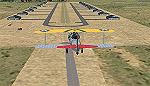
| YBSS Bacchus Marsh AU |

|
Images related to this file:
File Description:
Bacchus Marsh Airfield is located approx 40km WNW of Melbourne, Victoria, Australia. It was never included in the original FSX.
This package incorporates a choice of blending into either the fsx default landscape or the Orbx AU landscape. This airport has been modeled from photographs freely available off the internet.
A folder is enclosed to give comparisons of detail at ground level. In Display Settings, set texture resolution as desired.
All hangars are my generic ones and chosen for similarity in shape, colour and size to the real ones on the ground. The package includes about 100 FSDS custom made scenery objects ranging from hangars to ground litter and many in
between, useful for also installing in other rural airports via a scenery editor. It includes some grass and tussocks vegetation to help give the visual of a rural airfield.
| Filename: | YBSS_Bacchus_Marsh_AU.zip |
| License: | Freeware |
| Added: | 10th September 2016, 03:26:23 |
| Downloads: | 727 |
| Author: | Robert Budd |
| Size: | 9.36 MB |
| Category: Flight Simulator X - Scenery | |
| KLAW - Fort Sill Regional / Lawton Muni - Oklahoma, USA |
|
Images related to this file:
File Description:
FSX Scenery - Lawton Fort Sill Regional Airport (IATA: LAW[2], ICAO: KLAW, FAA LID: LAW) is a city owned airport two miles south of Lawton, in Comanche County, Oklahoma. It is used for military aviation from nearby Fort Sill and Sheppard Air Force Base and is served by American Eagle. Allegiant Air runs occasional charters to various destinations in the western United States. The National Plan of Integrated Airport Systems for 2011-2015 categorized it as a primary commercial service airport. Federal Aviation Administration records say the airport had 77,533 passenger boardings (enplanements) in calendar year 2008, 71,389 in 2009 and 68,054 in 2010. The 2013 Federal sequester will result in the closure of the airport's control tower and will require pilots to rely on air traffic controllers from other area airports. For your flying pleasure by John B. Loney, Jr.
| Filename: | KLAW__Fort_Sill_Regional__Lawton_Muni__Oklahoma_US.zip |
| License: | Freeware, limited distribution |
| Added: | 19th August 2015, 20:58:38 |
| Downloads: | 597 |
| Author: | John B. Loney, Jr. |
| Size: | 12.61 MB |
| Category: Flight Simulator X - Scenery | |
| FA44 - Willis / Boynton Beach - Miami, Florida - USA |
|
Images related to this file:
File Description:
Neighbor to my 'Antiquers Aerodrome' here at avsim, Willis is another small grass strip just North of Antiquers Aerodrome in the Miami/Ft. Lauderdale area.
I gave it a light touch-up, changed concrete taxiways to oil-treated, added an avgas station, lit the runway, fenced it, an added a small parking lot.
This is a bee-utiful area to fly around in with many many airports. Some are nothing more than a a unmarked no bldg. grass strip all the way up to Miami International. Bahamas a short hop to the East, and Key West to the south. Best observed low & slow in an 'ol tail-dragger.
Three freeware beauties are included to get you started: A.F. Scrub's Fairey Fantome, Yak air7, and P. Clawson's Stinson Voyager.
They are written into the Traffic file along with the retro-paints MS Piper Cub and Mooney Bravo.
| Filename: | FA44__Willis__Boynton_Beach__Miami_Florida__USA.zip |
| License: | Freeware, limited distribution |
| Added: | 18th November 2014, 15:01:10 |
| Downloads: | 464 |
| Author: | Jeff Reed |
| Size: | 16.46 MB |
| Category: Flight Simulator X - Scenery | |
| Victoria, Canada including US Southern Gulf Islands and San Juan Islands - Part 2 of 2 |
|
Images related to this file:
File Description:

FSX-only version of Victoria, Canada area scenery including the Southern Gulf Islands and the San Juan Islands of the US. Includes automated installer and configurator by Scot Fraser.
Features:
-accurate shorelines, lakes and streams;
-landclass;
-FSX multi-LOD mesh with 10m maximum resolution;
-complete road network with moving traffic;
-railroads;
-utility corridors;
-marinas and ferry terminals;
-many static boats, including a custom model of the Canada Coast Guard ship Sir Wilfred Laurier;
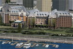
-detailed models of major buildings and the Ogden Point Terminal;
-many bridges;
-nearly 300 marine lights; and corrected antennae locations.
Facilities include Don Grovestine's famous CYYJ (Victoria International Airport); 12 other Canadian land-based airports: Butler Field, Duncan (CAM3), Gaines, Hastings, Hudson Island, James Island, Thomas, Village Bay, Raven Field (CML2), Saltspring, Sidney Island, Whiskey Point; 20 US airports Blakely (38WA), Burden (61WA), Center Island (79WA), Clam Harbor (WA35), Crane Island, Decatur Shores (WN07), Decatur-Jones (WA18), Waldronaire (90WA), Orcas Island (KORS), Friday Harbour (KFHR), Lopez Island (S31), Pile Point, Roche Harbor (WA09), Shaw Island, Stuart Island Airpark (7WA5), Stuart Island West (2WA3), Wilding (6WA5), Windsock (4WA4); 12 floatplane facilities: Bedwell (CAB3), Fisherman's Bay (WA81), Friday Harbor (W33), Ganges (CAX6), Maple Bay, Mayne (CAW7), Port Washington (CAP8), Roche Harbor (W39), Rosario (W49), Shawnigan Lake (CAV8), Victoria Harbour (CYWH), Victoria International (CAP5) and Westsound, Orcas (WA83) - many with AI traffic; 9 heliports: Ganges (CAL7), Mayne (CBF5), Camel Point (CBF7), Jubilee (CBK8), Victoria General (CBW7) Madrona Bay (CBW9), Shoal Point (CBZ7), Mount Belcher (CMBH).
AI models include the DHC-2 floatplane in local liveries, a cruise ship model (by Mitsuya Hamaguchi) and two repaints, pilot boat, and small boats (by Larry Silsbee).
Ultimate Terrain X compatible (not required). Users of Vancouver+ for FSX will also get additional cruise ship traffic and additional floatplane and helicopter traffic. Full documentation. By Don Grovestine, Jon Patch and Holger Sandmann. Many other contributors: see documentation. Part 2 of 2 - you also need file vicenh7a.zip
| Filename: | Victoria_Canada_including_US_Southern_Gulf_Islands.zip |
| License: | Check within download |
| Added: | 29th January 2010, 21:21:49 |
| Downloads: | 23,161 |
| Author: | Don Grovestine, Jon Patch and Holger Sandmann |
| Size: | 59.08 MB |
| Category: Flight Simulator X - Scenery | |
| Victoria, Canada including US Southern Gulf Islands and San Juan Islands - Part 1 of 2 |
|
Images related to this file:
File Description:
FSX-only version of Victoria, Canada area scenery including the Southern Gulf Islands and the San Juan Islands of the US. Includes automated installer and configurator by Scot Fraser.
Features:
-accurate shorelines, lakes and streams;
-landclass;
-FSX multi-LOD mesh with 10m maximum resolution;
-complete road network with moving traffic;
-railroads;
-utility corridors;
-marinas and ferry terminals;
-many static boats, including a custom model of the Canada Coast Guard ship Sir Wilfred Laurier;
-detailed models of major buildings and the Ogden Point Terminal;
-many bridges;
-nearly 300 marine lights; and corrected antennae locations.
Facilities include Don Grovestine's famous CYYJ (Victoria International Airport); 12 other Canadian land-based airports: Butler Field, Duncan (CAM3), Gaines, Hastings, Hudson Island, James Island, Thomas, Village Bay, Raven Field (CML2), Saltspring, Sidney Island, Whiskey Point; 20 US airports Blakely (38WA), Burden (61WA), Center Island (79WA), Clam Harbor (WA35), Crane Island, Decatur Shores (WN07), Decatur-Jones (WA18), Waldronaire (90WA), Orcas Island (KORS), Friday Harbour (KFHR), Lopez Island (S31), Pile Point, Roche Harbor (WA09), Shaw Island, Stuart Island Airpark (7WA5), Stuart Island West (2WA3), Wilding (6WA5), Windsock (4WA4); 12 floatplane facilities: Bedwell (CAB3), Fisherman's Bay (WA81), Friday Harbor (W33), Ganges (CAX6), Maple Bay, Mayne (CAW7), Port Washington (CAP8), Roche Harbor (W39), Rosario (W49), Shawnigan Lake (CAV8), Victoria Harbour (CYWH), Victoria International (CAP5) and Westsound, Orcas (WA83) - many with AI traffic; 9 heliports: Ganges (CAL7), Mayne (CBF5), Camel Point (CBF7), Jubilee (CBK8), Victoria General (CBW7) Madrona Bay (CBW9), Shoal Point (CBZ7), Mount Belcher (CMBH).
AI models include the DHC-2 floatplane in local liveries, a cruise ship model (by Mitsuya Hamaguchi) and two repaints, pilot boat, and small boats (by Larry Silsbee).
Ultimate Terrain X compatible (not required). Users of Vancouver+ for FSX will also get additional cruise ship traffic and additional floatplane and helicopter traffic. Full documentation. By Don Grovestine, Jon Patch and Holger Sandmann. Many other contributors: see documentation. Part 1 of 2 - you also need file vicenh7b.zip
| Filename: | Victoria_Canada_including_US_Southern_Gulf_Islands.zip |
| License: | Check within download |
| Added: | 29th January 2010, 21:23:17 |
| Downloads: | 23,158 |
| Author: | Don Grovestine, Jon Patch and Holger Sandmann |
| Size: | 56.8 MB |
| Category: Flight Simulator X - Scenery | |
| YPTN RAAF Tindal, Australia |
|
File Description:
Ants Aussie Airports Vol 5 : RAAF Tindal is a military base about 290kms south east of Darwin near the town of Katherine in Australia's Northern Territory. Tindal is a major front-line operational air base and home to No. 75 Squadron Air Combat Group (F/A-18). There is also a civilian apron in the north west corner of the airfield. This scenery contains photoreal ground textures and these are designed to blend in with the payware FTX textures (available from www.fullterrain.com). It is therefore recommended that you have the FTX textures installed if you wish to see this airfield at its best. I have tried to make this airfield as accurate as possible although as Tindal is a military base there aren't a lot of photos available so a lot of the hangars are "educated guesses". Almost all of the models have been custom made with the use of library objects kept to the minimum.
| Filename: | YPTN_RAAF_Tindal_Australia.zip |
| License: | Freeware, limited distribution |
| Added: | 6th January 2009, 13:49:54 |
| Downloads: | 3,629 |
| Author: | Anthony Lynch |
| Size: | 30.62 MB |
| Category: Flight Simulator X - Scenery | |
| Lost River ASU Observatories |
|
Images related to this file:
File Description:
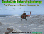
This is a fictitous scenery of the Alaska State University operated North-Western observatories.
It is located near LSR_Lost River and AK45_Lost River_2 on the Western coast of Alaska.
LSR, AK45 and KPC_Port Clarence have been upgraded with hangers and various objects.
LSR, AK45 and the (2) mountain top observatories have been upgraded with helipads along with various ground vehicles including snocats, aircraft, misc buildings and hangers. The main observatory complex has a main rooftop pad and a heli-tower. These helipads were designed for heli practice. some are on the ground and others are a bit more challenging.
There is a map included which shows the locations of the observatory complexes in relation to the airports. There is also a small research facility located to the east which is indicated on the map. This fictional scenery was design with default FSX 3D objects and (1) addon library, fa_ez-arctic_set by Finney Air, Robert Finnegan.
| Filename: | Lost_River_ASU_Observatories.zip |
| License: | Freeware |
| Added: | 11th November 2009, 19:11:39 |
| Downloads: | 557 |
| Author: | Tim Durham |
| Size: | 3.41 MB |
| Category: Flight Simulator X - Scenery | |
| CYDA - Dawson Airport - Yukon, Canada |
|
Images related to this file:
File Description:
FSX Scenery - Dawson City Airport (IATA: YDA, ICAO: CYDA) is located 8 nautical miles (15 km; 9.2 mi) east of Dawson City, Yukon, Canada, in the Klondike River valley, and is operated by the Yukon government. It has a terminal building and like most airports in its class, the runway is not paved. The gravel runway is 5,006 ft (1,526 m) long and at an elevation of 1,215 ft (370 m). A number of studies have recommended moving the airport or realigning the runway as it is in a narrow mountain valley. The airport is classified as an airport of entry by Nav Canada and is staffed by the Canada Border Services Agency (CBSA). CBSA officers at this airport can normally handle aircraft with up to 15 passengers, but are equipped to handle daily Boeing 737 charters between Dawson City and Fairbanks (Fairbanks International Airport) during the peak summer tourism season. For your flying pleasure by John B. Loney, Jr.
| Filename: | CYDA__Dawson_Airport__Yukon_Canada.zip |
| License: | Freeware, limited distribution |
| Added: | 7th April 2016, 17:20:42 |
| Downloads: | 901 |
| Author: | John B. Loney, Jr. |
| Size: | 13.92 MB |
| Category: Flight Simulator X - Scenery | |
| Aeropuertos de Isla San Andrés y de Isla Providencia (SKSP & SKPV), Colombia. |
|
File Description:
The delivery includes TWO airports: 1- Gustavo Rojas Pinilla (SKSP) on San Andrés Island, 2- El Embrujo (SKPV) on Providencia Island; both belonging to Colombia (Caribbean Area).
The delivery includes conditioning of the runways and taxiing of the airport facilities using original objects from the FSX Acceleration Pack.
The height of the terrain of the islands was also conditioned, and various objects that force you to take a low-altitude plane or helicopter ride for observation and discovery.
In Providencia you can try a landing approaching by the sea very close to the tropical forest (includes app positions to use gps in flight planner); In the same way, dare to take off on Route 35 without running into the treetops, trusting in your ability.
In San Andrés there will be many tourists on the runway headwaters taking photos of your aircraft arriving or departing from the airport !! They are waiting for you!
| Filename: | Aeropuertos_de_Isla_San_Andrs_y_de_Isla_Providenci.zip |
| License: | Freeware |
| Added: | 8th January 2021, 23:31:13 |
| Downloads: | 871 |
| Author: | Cristóbal Laje Ros |
| Size: | 23.63 MB |
| Category: Flight Simulator X - Scenery | |
| SCIP - Isla de Pascua & Mataveri Intl - Easter Island |
|
Images related to this file:
File Description:
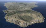
This project rebuilds Easter Island / Isla de Pascua. Mataveri Intl (SCIP) is completely overhauled, and all airport objects are aligned from satellite imagery. Landclass polygons and coastlines were meticulously hand-drawn directly from satellite imagery to provide the most detailed and accurate scenery available for this region. AI road and boat traffic is activated for the region. Accurate coastlines and road data, as well as corrected land and waterclass are provided based on the latest available satellite imagery. GA flights use default aircraft and include an option to add Chilean Air Force planes around the island. Numerous Moai (Easter Island heads) have been placed around the island according to satellite imagery. Scenery was created using Airport Design Editor X v1.61.5298, SBuilderX 3.13, and the FSX Object Placement Tool. Scenery objects were added and modified from stock FSX scenery to resemble as closely as possible the actual airports. The FSX apron lights included are from the terrific set created by Jim Dhaenens.
| Filename: | SCIP__Isla_de_Pascua__Mataveri_Intl___Easter_Islan.zip |
| License: | Freeware |
| Added: | 12th July 2014, 08:17:55 |
| Downloads: | 5,713 |
| Author: | Carlyle Sharpe |
| Size: | 5.33 MB |
© 2001-2026 AVSIM Online
All Rights Reserved
Privacy Policy |