
Where Flight Simulation Enthusiasts Gather from Around the World!
AVSIM Library - Search Results

| Category: Flight Simulator X - Scenery | |
| EGLL - Heathrow Intl Airport - London, UK |

|
Images related to this file:
File Description:
This airport update is for EGLL and made only for FSX: The new Terminal 2A and 2B added, Terminal 3 pier six now has four gates added for the A380, Terminal 5 now has five gates added for the BA A380, taxiways, taxi signs and parking stands all updated to the latest charts, assigned parking as per their website this includes the airlines that will be moving to the new Terminal 2 later this year, extra parking also included, Cargo area rebuilt, extra fuel trucks, start location added to the lighted helipad, support vehicle roads rebuilt and many other scenery improvements, airport views are from inside the control tower (when in tower view) please view the readme before installation
| Filename: | EGLL__Heathrow_Intl_Airport__London_UK.zip |
| License: | Freeware, limited distribution |
| Added: | 18th April 2014, 07:10:43 |
| Downloads: | 50,609 |
| Author: | Ray Smith & Craig Scott |
| Size: | 1.67 MB |
| Category: Flight Simulator X - Scenery | |
| KAFW Fort Worth Alliance Airport - Texas, US |
|
Images related to this file:
File Description:
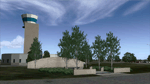
Ft. Worth Alliance Airport opened in 1989 and was billed as the world's first purely industrial airport. It is located around 14 miles North of the central business district of Ft. Worth and is also nearby the Dallas/Ft. Worth International Airport (KDFW). The airport serves general aviation, corporate jet, cargo, and military air traffic on a daily basis and it's proximity to the Texas Motor Speedway (only a few miles) brings extra dense traffic on race weekends. The airport is home to the American Airlines 777 and 767 maintenance base, FedEx Southwest Regional Sort Hub, Bell-Helicopter Training Center, DEA Air Operations Center and DynCorp International. Sadly the American Airlines maintenance base is set to close at the end of 2012 but is being kept alive in FSX!
This scenery features custom 3d buildings and objects bringing you a very accurate rendition of Ft. Worth Alliance Airport. Requires FSX Acceleration for the all scenery objects to display correctly.
Note: These files MUST be installed for the scenery to work correctly (otherwise there will be missing scenery objects at the airport):
-Filename: fsx_lts.zip - Ramp Lighting for FSX by Jim Dhaenens
-Filename: dlfcorelibraries2fsx.zip - Dan French Core Library Vol. 2
-Filename: lightstoo.zip - Jim Dhaenens Airfield Lighting
-Filename: objlib-jgse-fsx.zip - John Stinstrom JGSE Yellow Objects - this newer file replaces the older FS9 libraries with FSX versions
-Filename: objlib-ggse-fsx.zip - John Stinstrom GGSE Green Objects - this file also replaces FS9 libraries with FSX versions
| Filename: | KAFW_Fort_Worth_Alliance_Airport__Texas_US.zip |
| License: | Freeware, limited distribution |
| Added: | 12th December 2012, 16:56:36 |
| Downloads: | 2,932 |
| Author: | Brandon Thetford |
| Size: | 439.24 MB |
| Category: Flight Simulator X - Scenery | |
| Amundsen-Scott Station |
|
File Description:
The Amundsen-Scott South Pole Station is the American scientific research station on the high plateau of Antarctica. This station is located at the southernmost place on the Earth, the Geographic South Pole, at an elevation of 2,835 meters (9301 feet) above sea level.
Since the Amundsen-Scott Station is located at the South Pole, it is at the only place on the land surface of the Earth where the sun is continuously up for six months and then continuously down for six months. (The only other such place is at the North Pole, on the sea ice in the middle of the Arctic Ocean.) Thus, during each year, this station experiences one extremely long "day" and one extremely long "night". During the six-month "day", the angle of elevation of the Sun above the horizon varies continuously. The sun rises on the September equinox, reaches its maximum angle above the horizon on the summer solstice in the Southern Hemisphere, around 20 December, and sets on the March equinox.
During the six-month "night", it gets extremely cold at the South Pole, with air temperatures sometimes dropping below -73�°C (-100�°F). This is also the time of the year when blizzards, sometimes with gale-force winds, strike the Amundsen-Scott Station. The continuous period of darkness and dry atmosphere make the station an excellent place from which to make astronomical observations.
This file has the apron and characteristics of the airport the coordenates are placed as far south as FS allow it.
| Filename: | AmundsenScott_Station.zip |
| License: | Freeware |
| Added: | 17th October 2011, 22:01:33 |
| Downloads: | 1,295 |
| Author: | Anwar Gonzalez |
| Size: | 5.92 KB |
| Category: Flight Simulator X - Scenery | |
| RAF Atcham |
|
File Description:
Royal Air Force Atcham or more simply RAF Atcham is a former Royal Air Force station located 5.0 miles (8.0 km) east of Shrewsbury, Shropshire, England, on the north eastern boundary of Attingham Park.
Initially built for RAF Fighter Command, during the Second World War its primary use was by the United States Army Air Forces (USAAF) Eighth Air Force. It was mainly the home of the 495th Fighter Training Group, where pilots were trained to fly Republic P-47 Thunderbolts although a few also were trained to fly twin-engined Lockheed P-38 Lightnings for both Eighth and Ninth Air Force units. Atcham continued to see use as a training base until it was returned to the RAF in March 1945.
Source:Wikipedia
| Filename: | RAF_Atcham.zip |
| License: | Freeware |
| Added: | 7th February 2017, 21:22:53 |
| Downloads: | 139 |
| Author: | Terry Boissel |
| Size: | 82.57 MB |
| Category: Flight Simulator X - Scenery | |
| Flags and Signs |
|
File Description:
This package provides a little collection of flags and signs for scenery designers for FSX. The models have been developed with GMAX. Along with the textures the package includes the mdl files, and the XML files for the individual placement of the objects into a scenery. The bgl files are included as well.
The documentation (see pdf file in the ZIP) contains a step by step description on how to place the objects into the FSX scenery. A gauge for a proper positioning of the objects is part of the package.
CREDIT goes to:
Bob Familton for spending his time on review the package and the documentation.
Gary Mills, Robert Finnegan, Kevin Bryan, for the helpful package chplus.zip,
and Jim Robinson for the helpful package ch_pnl.zip .
| Filename: | Flags_and_Signs.zip |
| License: | Freeware |
| Added: | 18th February 2010, 04:16:51 |
| Downloads: | 638 |
| Author: | Dietmar Loleit |
| Size: | 1.71 MB |
| Category: Flight Simulator X - Scenery | |
| The Thames Barrier - England |
|
Images related to this file:
File Description:

This scenery adds the Thames Barrier to Orbx EU England Regional scenery package. Compatible with both FSX & P3D. The Thames Barrier is the world's second-largest movable flood barrier (after the Oosterscheldekering in the Netherlands) and is located downstream of central London, United Kingdom. Its purpose is to prevent London from being flooded by exceptionally high tides and storm surges moving up from the sea. It needs to be raised (closed) only during high tide; at ebb tide it can be lowered to release the water that backs up behind it. Not tested with default FSX or any other setup. You must have Orbx EU England regional scenery to use the compiled scenery files as intended. By Bryan Wallis aka fltsimguy.
| Filename: | The_Thames_Barrier__England.zip |
| License: | Freeware, limited distribution |
| Added: | 27th January 2013, 01:08:30 |
| Downloads: | 1,339 |
| Author: | Bryan Wallis |
| Size: | 584.23 KB |
| Category: Flight Simulator X - Scenery | |
| CZBB - Boundary Bay, BC, Canada (2011) Version 2 |
|
Images related to this file:
File Description:
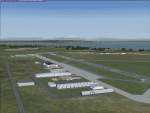
CZBB (2011) portrays the Boundary Bay (British Columbia, Canada) Airport (CZBB) - Canada's fifth-busiest airport by number of operations - and surrounding area as it appeared in mid-2011. Every significant structure on the airfield (50+) is included - all modeled with GMax and painted with hand-drawn textures. CZBB (2011) is compatible with ORBX FTX USA Canada Pacific Northwest, Ultimate Terrain and Vancouver+. A selection of SAMM-generated static aircraft are scattered around the aprons supplemented by a number of AI aircraft that do touch 'n gos from time to time.
Aside from the new custom approach and airfield lighting, generally, this new version is visually identical to its predecessor - even though quite different internally. As well, to the extent possible, it is compatible with Prepar3Dv2.
| Filename: | CZBB__Boundary_Bay_BC_Canada_2011_Version_2.zip |
| License: | Freeware, limited distribution |
| Added: | 20th June 2014, 05:10:24 |
| Downloads: | 3,486 |
| Author: | Don Grovestine |
| Size: | 73.9 MB |
| Category: Flight Simulator X - Scenery | |
| IGT - Nightmute Airport - Alaska, USA |
|
Images related to this file:
File Description:
The airport islocated southeast of the central business district of the vellage of Nightmute.Nightmute is located on Nelson Island near Toksook Bay. The two villages connect by snowmachine trail in winter.
Runway 2/20 was changed to 3/21. Changed the length of Runway 3/21 from 50 feet wide and a legth of 1,600 feet to 75 feet wide and 3,200 feet long.Added Runway 11/29 along with custom models.Changes are based on construction plans dated 2005.
Created with Airport Design Editor by ScruffyDuck Software using current FAA documentation and Google Earth's measurements, this package offers a replacement for FSX's stock airport. All these enhancements are as close to the real airport as I can get with stock library objects and custom buildings.
| Filename: | IGT__Nightmute_Airport__Alaska_USA.zip |
| License: | Freeware |
| Added: | 3rd February 2015, 09:12:14 |
| Downloads: | 669 |
| Author: | Wayne Roberts |
| Size: | 197.17 KB |
| Category: Flight Simulator X - Scenery | |
| Ermelo Airport (FAEO), South Africa |
|
Images related to this file:
File Description:
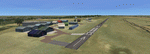
Ermelo is a delightfully cool, high- lying town on the eastern highveld of Mpumalanga District of South Africa. Because of its geographical situation on the eastern border of the jutting out position of Swaziland, it is a popular refueling airfield for smaller aircraft, when not flying through the airspace of Swaziland from the NE of Limpopo Province to the SE of Kwazulu Natal or back. An airfield that is very often covered in morning fog during the months from February to May.
A photo realistic attempt of the airport was made by the team and the result was quite an accurate replica on the true footprints of the actual buildings. Does require fsxWorx01.zip and updates.
| Filename: | Ermelo_Airport_FAEO_South_Africa.zip |
| License: | Freeware |
| Added: | 12th April 2013, 20:26:50 |
| Downloads: | 2,346 |
| Author: | Hannes Steyn, Martin du Preez, Aeroworx |
| Size: | 15.27 MB |
| Category: Flight Simulator X - Scenery | |
| Gen Mitchell Intl Airport (KMKE) Milwaukee, Wisconsin, USA |
|
Images related to this file:
File Description:
This is an accurate and up-to-date version of General Mitchell Intl Airport with two optional files and made only for FSX: one version with the Crosswind runways operating where all 5 runways will be used for takeoff/landing and one version as the default airport runway operation, assigned parking as per their website with extra parking, Concourse E Closed May 24, 2017 Airlines: None, all runways now at their correct lengths, new control tower, taxiways and taxi signs updated to the latest charts, support vehicle roads rebuilt, extra fuel trucks, Helipad included, and many other scenery improvements and objects added, airport views are from the roof of the new control tower (when in tower view) please view the readme before installation
| Filename: | Gen_Mitchell_Intl_Airport_KMKE_Milwaukee_Wisconsin.zip |
| License: | Freeware, limited distribution |
| Added: | 13th November 2017, 00:09:15 |
| Downloads: | 20,541 |
| Author: | Ray Smith |
| Size: | 5.06 MB |
© 2001-2026 AVSIM Online
All Rights Reserved
Privacy Policy |