
Where Flight Simulation Enthusiasts Gather from Around the World!
AVSIM Library - Search Results

| Category: Flight Simulator X - Scenery | |
| RAF Polebrook |

|
File Description:
On June 28, 1942, RAF Polebrook was officially turned over to the USAAF and the airbase became the base of the 97th Bombardment Group, the first USAAF heavy bomber organization to arrive in the UK. It was designated USAAF Station 110.
The 97th BG was assigned to the 1st Combat Wing, at RAF Bassingbourn. It's operational squadrons were divided between Polebrook and RAF Grafton Underwood:
340th Bomb Squadron (RAF Polebrook)
341st Bomb Squadron (RAF Polebrook)
The 97th BG conducted a total of 14 missions from Polebrook, attacking airfields, marshalling yards, industries, naval installations, and other targets in France and the Low Countries.
The group sortied 247 aircraft, dropped 395 tons of bombs on Nazi-controlled territory, and lost 14 aircraft. On October 21, 1942, the 97th Bomb Group was transferred to the Twelfth Air Force in the Mediterranean theater and Polebrook was unoccupied until April 1943.
351st Bombardment Group (Heavy)
On April 15, 1943, the 351st Bomb Group arrived at RAF Polebrook. It was assigned to the 94th Combat Wing, also at Polebrook. The group tail code was a "Triangle J". It's operational squadrons were:
508th Bomb Squadron (YB)
509th Bomb Squadron (RQ)
510th Bomb Squadron (TU)
511th Bomb Squadron (DS)
Boeing B-17G-85-BO Flying Fortress, Serial 43-38465 of the 510th Bomb Squadron. This aircraft survived the war and returned to USA on 8 June 1945
Douglas-Long Beach B-17G-30-DL Flying Fortress Serial 43-38116 of the 509th Bomb Squadron.The 351st's first completed combat mission took place on May 14, 1943, when 18 B-17's targeted a German Luftwaffe airfield at Kortrijk, Belgium. As the war progressed, the 351st operated primarily against strategic objectives in Germany, striking such targets as ball-bearing plants at Schweinfurt, communications at Mayen, marshalling yards at Koblenz, a locomotive and tank factory at Hannover, industries at Berlin, bridges at Cologne, an armaments factory at Mannheim, and oil refineries at Hamburg.This is for FSX and you will need to have Ted Andrews's RAF Hangars Library and his other great RAF Buildings. They can
be found on AVSIM. Search the FSX section for "Ted Andrews" - you'll find loads of his scenery object files for
RAF airfields. Follow his instructions on how to install them.
| Filename: | RAF_Polebrook.zip |
| License: | Freeware |
| Added: | 21st January 2009, 13:27:45 |
| Downloads: | 1,058 |
| Author: | Scott Berge |
| Size: | 15.01 KB |
| Category: Flight Simulator X - Scenery | |
| Pagasa Island, Philippines |
|
Images related to this file:
File Description:
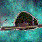
Pagasa Island is a jewel in the South China Sea. It is the one pictured - an emerald splash in an azure sea slashed by a coral runway - whenever new collisions or confrontations are reported in the news for the region. Occupied continuously by the Philippines since 1971, historical use dates back to the Han dynasty, which many believe forms the basis of the Chinese claim to the island. Each country has it's own interpretation of international law and the Filipinos are clearly banking on the precedence of continuous occupation, at no small expense, as Rancudo Field is the farthest airport from Manila within the Philippine sphere of control.
Surprisingly, the geography of the island serves to capture and retain rainwater, although the aquifer is stagnant and the water must be treated for consumption. Sea life remains abundant, poachers take coral heads and sea turtles. There is a solar farm and recently installed solar street lights, fuel for the generators is a precious commodity this far from the mainland.
Sadly, nature may solve the struggle for possession by withdrawing the island from the arena. It is believed that the construction of the runway may have compromised the islands basic integrity, allowing it to crumble into the sea. Whatever the cause, the evidence is clear. Bunkers built during the Japanese occupation in WWII are already slipping beneath the waves and the rate of salt water encroachment has been recorded at close to 6" per day.
There are some things to explore, the grounded BRP Laneo Del Norte to the west; over to the north near the resort grounds are a dugout fishing canoe and some authentic Philippine bangka boats; you may want to load up and head east to do some low warning passes over the Chinese fishing fleet. Standing at the east end of the field, you can just barely spot the China Coast Guard cutter's smoke on the horizon.
The tower is marked by a bright strobe that fires once every five seconds and at night it is bright enough to guide you back to the island from the distance of the fleet. There are no published procedures and the tower is not staffed. Airport ICAO is RPPN.
| Filename: | Pagasa_Island_Philippines.zip |
| License: | Freeware, limited distribution |
| Added: | 10th May 2014, 12:21:19 |
| Downloads: | 1,851 |
| Author: | Rick Keller |
| Size: | 16.17 MB |
| Category: Flight Simulator X - Scenery | |
| Merrill Field PAMR |
|
Images related to this file:
File Description:
This is a version for FSX of the Merrill Field made by Roger Wensley (me) for FS9, converted by John B Loney jnr. "PAMR read this first" explains this but I have modified John's original procedure, and instead of first installing the Merrill Field original plus two updates I have included here the current FS9 version as installed on my computer. Note that to see the apron lighting working in FS9 it was necessary to have Sidney Schwartz's light library installed, along with his updated textures (to avoid severe blurries caused by a faulty texture). The original installation instructions are included giving file library priorities etc. Just ignore the bits that do not apply, such as installing AI that is not included. I have of course omitted the original AI as this is replaced by John's version. I have no comment to make on installing in FSX as I have not done so, and I have not tested it in FSX. If you have comments or questions I will respond as much as I am able. Merrill Field is in Anchorage Alaska, between Anchorage International to the southwest and and Elmendorf Air Force Base to the north. It caters for general aviation and is the land equivalent of the Lake Hood float plane base, with fuel and numerous maintenance facilities, and several hundred parking spots for small planes. There are three runways, and the longest is 4,000 feet of 100 feet wide asphalt, the second 2,635 feet of asphalt 75 feet wide, and the third 2,000 feet of 60 feet wide gravel. The first two have runway lights. It is a controlled airfield with a relatively new control tower to cater for the numerous flights and to coordinate with Elmensdorf and Anchorage International, the latter also controlling flights from Lake Hood and the adjacent gravel strip Z41. (See my Lake Hood scenery). The gravel runway at Merrill Field is not connected with active taxiways to the rest of the airfield; this avoids you being ordered to land on it when flying a plane too large to do so.
| Filename: | Merrill_Field_PAMR.zip |
| License: | Freeware, limited distribution |
| Added: | 3rd July 2017, 18:00:19 |
| Downloads: | 451 |
| Author: | Roger Wensley and John B loney jnr |
| Size: | 21.73 MB |
| Category: Flight Simulator X - Scenery | |
| Concord NC X - Textures 5 ONLY |
|
File Description:
Kaleem Beats Sceneries Concord NC X includes:
- Up to date KJQF (Concord Regional Airport) (June 2015)
- Photoreal scenery in and around the Concord Regional Airport
- Custom night lighting!!
- Charlotte Motor Speedway (with Autogen)
- New parking at KJQF
- Longer runway to current 7000+ ft length at KJQF
- Autogen on photoscenery (not just textures but also autogen!)
REQUIRES these textures for scenery to work: ConcordXTextures1.zip , ConcordXTextures2.zip , ConcordXTextures3.zip , ConcordXTextures4.zip , ConcordXTextures5.zip , ConcordXTextures6.zip , ConcordXTextures7.zip , ConcordXTextures8.zip
| Filename: | Concord_NC_X__Textures_5_ONLY.zip |
| License: | Freeware |
| Added: | 25th June 2015, 08:06:23 |
| Downloads: | 283 |
| Author: | William Campbell |
| Size: | 71.3 MB |
| Category: Flight Simulator X - Scenery | |
| 2 Melbourne Helipads, Australia |
|
File Description:
Ants Aussie Airports Vol 3 : Melbourne Helipads. Here are 2 helipads which you can find floating on the Yarra River in the heart of Melbourne, Australia. The helipads have been custom modelled and are not boring old FSX library helipads. Note: these helipads require that you have the ORBX payware textures "FTX Blue" installed as well as the latest hotfixes (which flatten the river). FTX Blue redefines the coastlines and without them the Melbourne CBD looks pretty sad.
| Filename: | 2_Melbourne_Helipads_Australia.zip |
| License: | Freeware |
| Added: | 5th December 2008, 10:51:48 |
| Downloads: | 1,802 |
| Author: | Anthony Lynch |
| Size: | 325.15 KB |
| Category: Flight Simulator X - Scenery | |
| YWRC - Hyden 2 (Wave Rock), Western Australia |
|
File Description:
YWRC Hyden 2 (Wave Rock) - Wave Rock is a natural rock formation located east of the small town of Hyden in Western Australia. It derives its name from the fact that it is shaped like a tall breaking ocean wave. Wave Rock has cultural significance to Aborigines. More than 140,000 tourists visit wave rock every year. REQUIRES Blencowe_LibraryKit.zip
REQUIRES blencowe_librarykit_309494.zip (Available HERE)
| Filename: | YWRC__Hyden_2_Wave_Rock_Western_Australia.zip |
| License: | Freeware |
| Added: | 28th February 2013, 17:08:01 |
| Downloads: | 261 |
| Author: | Alan Blencowe |
| Size: | 7.52 MB |
| Category: Flight Simulator X - Scenery | |
| YDRD Drysdale River Station, Kimberley Region, Western Australia |
|
File Description:
YDRD Drysdale River Station with strip and homestead complex is a stopping over point for 4WD tourists and campers and provides some refreshment for those on the road. As a result it has become a sort of hub for the region and therefore ideally suited as a drop in for the Royal Flying Doctor. REQUIRES Blencowe_LibraryKit.zip
REQUIRES blencowe_librarykit_309494.zip (Available HERE)
| Filename: | YDRD_Drysdale_River_Station_Kimberley_Region_Weste.zip |
| License: | Freeware |
| Added: | 25th February 2013, 09:30:03 |
| Downloads: | 288 |
| Author: | Alan Blencowe |
| Size: | 4.13 MB |
| Category: Flight Simulator X - Scenery | |
| German_UL_Airfields_2 |
|
File Description:
50 UL airfields which are not included in FSX:
Peine, Bisperode, Bueren, Grifte, Warburg, Dehausen, Waldeck, Bad Wildungen, Schwalmstadt, Homberg, Giessen-Wieseck, Butzbach, Braunfels, Asslarer Huette, Hoerbach, Plaetzer, Alsfeld, Uslar, Aue-Hattorf, Burgberg, Hessisch-Lichtenau, Stauffenbuehl, Brakel, Hoppensen, Uehrde, Salzgittersee, Grosse Wiese, Dorstadt, Rote Wiese, Kunrau, Dingelstedt, Moeckern, Woermlitz, Erkelenz, Radevormwald, Waltrop, Dorsten, Emmerich-Palmerswardt, Kerken, Everswinkel, Metelen, Paradiek, Donstorf, Norddoellen, Quakenbrueck, Dankern, Lindlar, Vettweiss-Soller, Morschenich, Linnich-Boslar.
Update for Riesa-Canitz and Mellenthin from German_UL_Airfields_1
| Filename: | German_UL_Airfields_2.zip |
| License: | Freeware |
| Added: | 20th September 2017, 17:41:08 |
| Downloads: | 464 |
| Author: | Juergen Wolf |
| Size: | 35.23 MB |
| Category: Flight Simulator X - Scenery | |
| Lansdowne Monument |
|
File Description:
To the south-east of the White Horse, on top of Cherhill Down is the Lansdowne Monument. Erected in 1845 by the 3rd Marquis of Lansdowne to commemorate his ancestor Sir William Petty. It towers 125 feet (38 metres) above the hill and can also be seen 30 miles (48 Km) away. The hill now belongs to the National Trust. It is said that this is the highest point between London and Bristol. Lat 51 26' Lon 1 54'.
| Filename: | Lansdowne_Monument.zip |
| License: | Freeware, limited distribution |
| Added: | 27th October 2007, 17:57:06 |
| Downloads: | 712 |
| Author: | Steve Murnan |
| Size: | 111.1 KB |
| Category: Flight Simulator X - Scenery | |
| Cuatro Vientos LECU |
|
Images related to this file:
File Description:
Este escenario intenta recrear lo mas fielmente posible el aeropuerto de Cuatro vientos LECU en Madrid en FSX.
Este escenario esta realizado con ADE, Airport desing editor, basandome en las cartas de navegaci�³n de AENA y imagenes de Google Earth.
This Scenery recreate as closely as possible the Cuatro Vientos airport LECU from Madrid in FSX.
This scenery is made with ADE, Airport desing editor, based on navigational charts from AENA and images of Google Earth.
| Filename: | Cuatro_Vientos_LECU.zip |
| License: | Freeware, limited distribution |
| Added: | 30th November 2010, 23:43:54 |
| Downloads: | 2,147 |
| Author: | Luis LÃÂpez |
| Size: | 9.92 KB |
© 2001-2026 AVSIM Online
All Rights Reserved
Privacy Policy |