
Where Flight Simulation Enthusiasts Gather from Around the World!
AVSIM Library - Search Results

| Category: Flight Simulator X - Scenery | |
| GPS Enabled Oil Rig Platform |

|
File Description:
An FSX Oil rig placed at the correct real life coordinates about 100+ miles from Aberdeen and Peterhead. The landing pod has GPS facilities and a code of RIG1 Meaning you can start at the pod and/or fly to it by entering RIG1 into the GPS Direct To. A Cargo Ship sails from the tidal Aberdeen Harbour at 06:18 Local time and heads for Peterhead which is an hour away. It joins another Cargo ship there and the two set sail for the Piper alpha rig some 5 hours away. Sailings are twice a day and can be followed by boat plane. The rig landing pod is excellent for landing practice in a helicopter and especially with the built in GPS coordinates.
| Filename: | GPS_Enabled_Oil_Rig_Platform.zip |
| License: | Freeware |
| Added: | 20th November 2011, 00:43:58 |
| Downloads: | 574 |
| Author: | Steve Brooks |
| Size: | 6.26 KB |
| Category: Flight Simulator X - Scenery | |
| YCHP Yanchep St Andrews, Western Australia (Closed) |
|
File Description:
YCHP Yanchep St Andrews (Closed) was built by the Bond Corporation in the 60's for the development of the St Andrews Estate and Sun City development and has since fallen into disrepair. Alan Bond was a larger than life character and most of Western Australia will still remember his airship or his lear jet flying around Perth. I have placed a windsock and cones to help you find your way around on the ground because there is little else there. In real life, the strip may still look inviting but it is overgrown and most likely not safe. REQUIRES Blencowe_LibraryKit.zip
REQUIRES blencowe_librarykit_309494.zip (Available HERE)
| Filename: | YCHP_Yanchep_St_Andrews_Western_Australia_Closed.zip |
| License: | Freeware |
| Added: | 25th February 2013, 09:01:20 |
| Downloads: | 239 |
| Author: | Alan Blencowe |
| Size: | 1.4 MB |
| Category: Flight Simulator X - Scenery | |
| CYSG - St. Georges Aerodrome - v1.1 |
|
Images related to this file:
File Description:
Saint-Georges Aerodrome, (ICAO: CYSG), is a general aviation aerodrome located 1.5 nautical miles (2.8 km; 1.7 mi) west-southwest of Saint-Georges, Quebec, Canada near the border with Maine. The airport has a long, paved runway, suitable for use by jets. This scenery FSX Airport St-Georges was inspired by the great FS2004 scenery of the late pilot Virtual Hugues Caron img12. It was made very humbly in his memory. This FSX scenery been validated and tested with FSX SP1, SP2 and Acceleration. This is a complete reproduction, more accurate and realistic in Saint-Georges Beauce airport with all the buildings around it. For technical information or assistance contact one of the following email addresses support: [email protected] or [email protected]. Web site : http://imaginairvirtuel.qc.ca
| Filename: | CYSG__St_Georges_Aerodrome___v11.zip |
| License: | Freeware, limited distribution |
| Added: | 26th August 2013, 05:49:28 |
| Downloads: | 761 |
| Author: | Georges Bourgouin |
| Size: | 3.91 MB |
| Category: Flight Simulator X - Scenery | |
| MKBS - Boscobel Aerodrome - Ocho Rios, Jamaica |
|
File Description:
This is NOT a representation of the Ian Fleming International Airport. This is the Boscobel Aerodrome before the renovation which was much more challenging and busier as far as air traffic.
Neither FSX nor any third party gave Jamaican domestic airports enough attention to detail, so I messed around with an afcad file for MKBS. Also included is a bgl file for Ocho Rios, an important tourist town served by MKBS, that FSX basically forgets about. Though not necessary for this scenery to work correctly, I recommend Installing SceneryTech North America 1.4 as this scenery blends in nicely with it as it changes Jamaican vegetation completely.
This supersedes a file by Martin Erinin for FS2004. A pack of all the domestic airports in Jamaica.
| Filename: | MKBS__Boscobel_Aerodrome__Ocho_Rios_Jamaica.zip |
| License: | Freeware |
| Added: | 24th April 2014, 12:00:34 |
| Downloads: | 655 |
| Author: | Chris Zoepound / Martin Erinin |
| Size: | 7.44 MB |
| Category: Flight Simulator X - Scenery | |
| TACAN Replacements - US Complete |
|
File Description:
By default, all of the TACAN navigational aids present within FSX have the bearing component turned off, so as to properly represent the real world result of tuning in the DME component of a TACAN with a civilian plane. However, this limits their functionality when you wish to use them in conjunction with a plane (generally military) equipped with a representation of a functioning TACAN system.
This download contains 105 fixed/adjusted/changed navigational aids for the United States to represent all currently active TACAN stations. These navigational aids have all had the bearing component turned on, so that they are completely usable for navigation within the sim.
This package completely replaces any previous partial TACAN release for the United States.
| Filename: | TACAN_Replacements__US_Complete.zip |
| License: | Freeware |
| Added: | 17th June 2014, 16:15:09 |
| Downloads: | 1,227 |
| Author: | Jim Stewart |
| Size: | 111.71 KB |
| Category: Flight Simulator X - Scenery | |
| KLUA - Luray Caverns Airport - Luray, Virgina, USA |
|
Images related to this file:
File Description:
Luray Caverns Airport (ICAO: KLUA, FAA LID: LUA, formerly W45) is a public use airport located two nautical miles (4 km) west of the central business district of Luray, a town in Page County, Virginia, United States. The airport is owned by the Town of Luray and Page County.It is included in the National Plan of Integrated Airport Systems for 2011-2015, which categorized it as a general aviation airport.
Added taxiways and aircraft parkng along with custom buildings. Created with Airport Design Editor by ScruffyDuck Software using current FAA documentation and Google Earth measurements, this package offers a replacement for FSX's stock airport. All these enhancements are as close to the real airport as I can get with stock library objects and custom buildings.
| Filename: | KLUA__Luray_Caverns_Airport__Luray_Virgina_USA.zip |
| License: | Freeware |
| Added: | 29th November 2014, 14:11:35 |
| Downloads: | 315 |
| Author: | Wayne Roberts |
| Size: | 339.07 KB |
| Category: Flight Simulator X - Scenery | |
| TLPL Hewanorra International Airport |
|
File Description:
Hewanorra International Airport (IATA: UVF, ICAO: TLPL), near Vieux Fort Quarter, Saint Lucia, in the Caribbean, is the larger of the country's two airports and is managed by the Saint Lucia Air and Seaports Authority (SLASPA). The airport is a Fire Category 9 airport that handles 500,000 passengers a year and has the capability to handle the Boeing 747, Airbus A330, Airbus A340, Boeing 777 and other similar aircraft. Aircraft maintenance there is carried out by Caribbean Dispatch Services. George F. L. Charles Airport is located in Castries and handles inter-Caribbean flights.
This file has the right coordinates, with the apron and characteristics of the airport. The runways were re-sized the gates placed on correct location and number.
| Filename: | TLPL_Hewanorra_International_Airport.zip |
| License: | Freeware |
| Added: | 7th May 2011, 20:50:24 |
| Downloads: | 1,836 |
| Author: | Anwar Gonzalez |
| Size: | 9.13 KB |
| Category: Flight Simulator X - Scenery | |
| Hartebeespoort Dam, South Africa (Fictional Water Runway Airport) |
|
Images related to this file:
File Description:
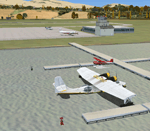
Due to no available airports in South Africa, with water runways in FSX, I decided to create a fictional airport at Hartebeespoort Dam with both a water runway as well as normal asphalt runway. FAHD also allows you to taxi from the main apron into the water as well as exit the water onto the main apron. 4 Water docking facilities also exist for aircraft with floats, which means you have a choice if you would like to start on the apron or at the water docks parking spaces. Amongst other facilities are ILS, NDB, Runway and Taxiway lights, 6 Small GA and 2 Medium GA Parking spot as well as refueling facility, a Tower and Small Terminal Building etc.
| Filename: | Hartebeespoort_Dam_South_Africa_Fictional_Water_Ru.zip |
| License: | Freeware |
| Added: | 26th March 2011, 19:50:07 |
| Downloads: | 393 |
| Author: | Otto Marais |
| Size: | 5.82 KB |
| Category: Flight Simulator X - Scenery | |
| KTTN - Trenton - Mercer Airport - New Jersey, USA |
|
Images related to this file:
File Description:
East Coast Simulations presents Trenton Mercer Airport Scenery for FSX/P3D! Trenton - Mercer Airport (IATA: TTN, ICAO: KTTN, FAA LID: TTN), sometimes also referred to as Trenton Mercer Airport, is a county-owned, joint civil military, public airport located four miles northwest of Trenton in the West Trenton section of Ewing Township, Mercer County, New Jersey. Formerly known as Mercer County Airport, the airport serves one scheduled airline plus general and corporate aviation. As reported in early 2014, about 325,000 passengers use the airport each year. This detailed scenery includes several custom buildings, a photoreal background for all seasons and custom ground polygons. This is the first release for East Coast Simulations, and more will be coming soon.
| Filename: | KTTN__Trenton__Mercer_Airport__New_Jersey_USA.zip |
| License: | Freeware |
| Added: | 30th June 2015, 23:45:58 |
| Downloads: | 1,112 |
| Author: | Wesley Chin and Kyle Kato |
| Size: | 91.41 MB |
| Category: Flight Simulator X - Scenery | |
| X2DA - RAF Down Ampney - Gloucestershire, England |
|
File Description:
RAF Down Ampney (ICAO X2DA) was a Royal Air Force station located 1.8 miles (2.9 km) north east of Cricklade, Wiltshire and 3 miles (4.8 km) south west of RAF Fairford, Gloucestershire.
The airfield operated during World War II from February 1944 until February 1947.
Down Ampney was part of a group of 3 airfields with RAF Broadwell and RAF Blakehill Farm dedicated to air transportation.
No. 48 Squadron RAF and No. 271 Squadron RAF flew Douglas Dakotas on major missions. On D-Day they dropped the main elements of the 3rd Parachute Brigade in Normandy as well as towing Airspeed Horsa gliders across the English Channel.
They were also active in Operation Market Garden (Arnhem) and the Rhine crossing.
Source: Wikipedia.
| Filename: | X2DA__RAF_Down_Ampney__Gloucestershire_England.zip |
| License: | Freeware |
| Added: | 16th April 2016, 11:37:35 |
| Downloads: | 148 |
| Author: | Terry Boissel |
| Size: | 1.94 MB |


© 2001-2026 AVSIM Online
All Rights Reserved
Privacy Policy |