
Where Flight Simulation Enthusiasts Gather from Around the World!
AVSIM Library - Search Results

| Category: Flight Simulator X - Scenery | |
| RAF Molesworth |

|
File Description:
At the start of World War II the Air Ministry selected the area as the site for what would become RAF Molesworth. The base was built in 1940 and 1941. The first unit, Royal Australian Air Force 460 Squadron was formed at the base on November 15, 1941 with Vickers Wellington IVs. 460 Squadron departed the field on January 4, 1942. RAF Bomber Command 159 squadron moved in shortly afterwards, however this unit did not remain long, moving to the Middle East on January 12.
Molesworth was one of the early Eighth Air Force stations assigned to the United States Army Air Force (USAAF). In February 1942, General Ira Eaker and four US staff members inspected Molesworth for possible American use, and during 1942 the facility was improved to Class A airfield standard, with all of its runways extended to American specifications for heavy 4-engined bombers. The main runway was lengthened to 2,000 yards and the number of hardstands increased to fifty. It was given USAAF designation as Station 107.
From 16 September 1943 – 18 June 1945, Molesworth served as headquarters for the 41st Combat Bombardment Wing of the 1st Bomb Division.
| Filename: | RAF_Molesworth.zip |
| License: | Freeware |
| Added: | 17th January 2009, 14:00:45 |
| Downloads: | 552 |
| Author: | Scott Berge |
| Size: | 22.77 KB |
| Category: Flight Simulator X - Scenery | |
| YDON Dowerin Town and Airstrip (Modelled for Dowerin Field Days) |
|
File Description:
YDON Dowerin is home to the Dowerin GWN Field Days, currently a two day annual event (held in the last week of August) showcasing agricultural and associated equipment, as well as providing information and services to people from rural areas. The Field Days attract on average in excess of 600 exhibitors as well as over 15,000 local and national visitors each day.
The event was first held as the Dowerin Machinery Field Day on 3 September 1965, and was the result of meetings by the Dowerin Progress Association the previous year which looked at ideas to prevent the town of Dowerin from becoming a ghost town. Some twenty exhibitors and two thousand visitors attended the first field day, with funds raised from the first event going towards funding the construction of a dam and a grassed tennis court. The event continues to be run and managed by the local community, with three full time staff and 400 volunteers involved in the event's running each year. REQUIRES Blencowe_LibraryKit.zip
REQUIRES blencowe_librarykit_309494.zip (Available HERE)
| Filename: | YDON_Dowerin_Town_and_Airstrip_Modelled_for_Doweri.zip |
| License: | Freeware |
| Added: | 25th February 2013, 09:03:28 |
| Downloads: | 241 |
| Author: | Alan Blencowe |
| Size: | 3.02 MB |
| Category: Flight Simulator X - Scenery | |
| Trois-Rivieres CYRQ |
|
Images related to this file:
File Description:
Trois-Rivieres Airport (CYRQ) is located near the city of Trois-Rivieres, Quebec, Canada, midway between Quebec and Montreal on the north shore of the St-Lawrence river. It has a large maintenance and painting shop to service aircrafts the class of B737, A320 or equivalent size. This GA airport had its runway (05-23) extended to 9000' so that is can now receive and accomodate the B767.
This scenery developed in GMax, is an exact and realistic representation of the airport. It features 28 detailed buildings including its unique terminal, custom vehicles and much more. From the airport, you can see the flashing strobe lights of the 1200 feet tower located 8 miles NE of the airport; cleary visible night and day which is a very good landmark coming in to land. Another nice landmark is the nearby beautiful Laviolette bridge (if installed from the same author). Take your favorite GA aircraft there for a sightseeing tour or a fishing trip a short distance north of Trois-Rivieres, your executive jet for a business meeting or service your airline jet in the maintenance bays. It is a nice airport to see.
| Filename: | TroisRivieres_CYRQ.zip |
| License: | Freeware |
| Added: | 26th November 2009, 02:43:30 |
| Downloads: | 7,252 |
| Author: | Gilles Boily |
| Size: | 6.9 MB |
| Category: Flight Simulator X - Scenery | |
| RAF Tarrant Rushton (1944) - Dorset, England |
|
File Description:
RAF Tarrant Rushton was a Royal Air Force station near the village of Tarrant Rushton east of Blandford Forum in Dorset, England from 1943 to 1947. It was used for glider operations during World War II and later revived for civilian operations. It is currently disused, though some buildings survive.
Horsa gliders from Tarrant Rushton left for France on the eve of D-Day, to begin Operation Tonga with an action that would later become known as Pegasus Bridge. Among the glider pilots was Jim Wallwork, on a Horsa nicknamed Lady Irene. The Tarrant Rushton gliders landed in occupied France shortly after midnight. Wallwork's aircraft was the first to touch down, but it landed heavily: the force of the impact catapulted both Wallwork and his co-pilot John Ainsworth through the front of the cockpit. Although stunned, this made them the first Allied troops to touch French soil on D-Day.
Other gliders were later flown from the airfield to Arnhem to take part in Operation Market Garden. During the closing stages of WWII, aircraft were used for SOE operations.
| Filename: | RAF_Tarrant_Rushton_1944__Dorset_England.zip |
| License: | Freeware |
| Added: | 22nd April 2016, 22:27:09 |
| Downloads: | 174 |
| Author: | Terry Boissel |
| Size: | 1.18 MB |
| Category: Flight Simulator X - Scenery | |
| Teterboro KTEB version 2.0 |
|
File Description:
FSX Scenery--Teterboro Airport (KTEB), NJ. Teterboro Airport is located across the Hudson River in New Jersey, just 12 miles from midtown Manhattan. Teterboro Airport is considered a general aviation reliever airport. As a reliever airport, it does not offer scheduled airline service, nor does it permit operations of any aircraft in excess of 100,000 pounds on any airport surface. Teterboro Airport has five Fixed Base Operators (FBOs), Atlantic Aviation, Jet Aviation, First Aviation, Meridian, and Signature Aviation. Teterboro - KTEB version 2 includes the latest google earth photo texture that depics the completed construction work of the taxiways and aprons. Photo texture includes summer, fall, winter, and spring variance textures. Night textures also included,along with snow textures in the winter months. Vegetation autogen has been re-worked. All taxiways, taxisigns are present and depicted to real-life. Custom taxilights and runway ground markings included, the ground detail is exact. All stock FSX hangars have been replaced with custom hangars. Animated people and birds are found on the airfield. Numerous SAMM generated static business jets and some light general aviation aircraft are present. Enjoy!
| Filename: | Teterboro_KTEB_version_20.zip |
| License: | Freeware |
| Added: | 14th April 2011, 16:57:39 |
| Downloads: | 2,618 |
| Author: | Eric McCloud |
| Size: | 52.63 MB |
| Category: Flight Simulator X - Scenery | |
| DAOR Bechar Airport |
|
File Description:
This is DAOR, Bechar airport, Algeria. Default FSX only has runways. This scenery adds taxiways, parking, air force dispersals etc (it is a mixed Civil/Military airport), placed according to Google Earth. Only default FSX objects have been used. This scenery will only work in FSX.
Built with ADE, from Scruffyduck Software
| Filename: | DAOR_Bechar_Airport.zip |
| License: | Freeware, limited distribution |
| Added: | 19th September 2008, 01:06:29 |
| Downloads: | 773 |
| Author: | Tim Arnot |
| Size: | 9.88 KB |
| Category: Flight Simulator X - Scenery | |
| LFFD - St Andre de l'Eure V2 |
|
Images related to this file:
File Description:
New version with more details. Airfield near Evreux (France). Absent in FSX. Activity: MICROLIGHT (ULM) and light aviation
Realized with the software ADE.
Compared with the first version, many details were added, particularly, the old disused south runway.
Tested with UTX Europe + Gex + TrueLandscape on a mesh of 38 m. FPS friendly.
| Filename: | LFFD__St_Andre_de_lEure_V2.zip |
| License: | Freeware, limited distribution |
| Added: | 7th September 2013, 22:23:54 |
| Downloads: | 897 |
| Author: | Christian Davi |
| Size: | 2.91 MB |
| Category: Flight Simulator X - Scenery | |
| KSLK - Adirondack Regional Airport - Saranac Lake, NY |
|
File Description:
Here is an improved version of the stock Adirondack Regional Airport. I added GA parking spaces. I replaced some buildings and added others, and added quite a bit of "eye-candy" in the form of static airplanes and vehicles, and other filler objects. I added some aprons and taxiways and adjusted others.
| Filename: | KSLK__Adirondack_Regional_Airport__Saranac_Lake_NY.zip |
| License: | Freeware |
| Added: | 14th October 2008, 13:12:52 |
| Downloads: | 962 |
| Author: | Jim Cook |
| Size: | 7.38 KB |
| Category: Flight Simulator X - Scenery | |
| Grange Farm |
|
File Description:
Grange Farm has been designed for use with Midland Microlights and Horizon/Just-Flight's VFR Scenery and is located near Market Rasen in Lincolnshire near to Scampton and Wickenby. Designed for use with the Horizon Terrain Mesh. Other meshes may cause a mis-alignment of hedges and fences.
www/northern-microlights-fsx.co.uk
| Filename: | Grange_Farm.zip |
| License: | Freeware |
| Added: | 17th October 2010, 23:34:47 |
| Downloads: | 216 |
| Author: | Neil Birch |
| Size: | 323.05 KB |
| Category: Flight Simulator X - Scenery | |
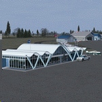
| Wings Field Airport KLOM aka N67 Blue Bell, Pennsylvania |
|
Images related to this file:
File Description:
Wings Field Airport is a general aviation airport located in Blue Bell Pennsylvania, within the Philadelphia area. Scenery included latest google earth photo scenery, with winter time textures. Autogen placed properly. Taxiways and Aprons depict real world. All scenery objects are custom made, no stock objects present. Static aircraft are included. Enjoy!!
| Filename: | Wings_Field_Airport_KLOM_aka_N67_Blue_Bell_Pennsyl.zip |
| License: | Freeware |
| Added: | 13th June 2011, 03:40:26 |
| Downloads: | 523 |
| Author: | Eric McCloud |
| Size: | 11.52 MB |
© 2001-2026 AVSIM Online
All Rights Reserved
Privacy Policy |