
Where Flight Simulation Enthusiasts Gather from Around the World!
AVSIM Library - Search Results

| Category: Flight Simulator X - Scenery | |
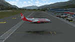
| Sphinx International Airport HESX Egypt |

|
Images related to this file:
File Description:
Sphinx International Airport HESX is new airport located western side of Cairo
adjacent and share some infrastructure with HECW airbase afcad file added for update,
Apron for 8 large category aircraft numbered in the correct order as chart
The airport reflect current satellite imagery and positioning ,
it should work for p3d
| Filename: | Sphinx_International_Airport_HESX_Egypt.zip |
| License: | Freeware |
| Added: | 9th January 2019, 17:49:21 |
| Downloads: | 1,334 |
| Author: | Mohamed Salamoni |
| Size: | 11.24 MB |
| Category: Flight Simulator X - Scenery | |
| Sishen Airport South Africa (FASS) |
|
Images related to this file:
File Description:
This is Sishen Airport in South Africa. It is completely custom designed with Custom terminal,hangars and admin buildings.It also has a custom AFCAD file with a photoreal background that changes with the seasons.FSX Acceleration will give the best results.(Also SP2 compatable).Acceleration users will have more eye candy!
| Filename: | Sishen_Airport_South_Africa_FASS.zip |
| License: | Freeware |
| Added: | 28th February 2017, 16:47:09 |
| Downloads: | 742 |
| Author: | Frits Beyer |
| Size: | 28.47 MB |
| Category: Flight Simulator X - Scenery | |
| KABE - Lehigh Valley International - Allentown, Pennsylvania, USA |
|
File Description:
The Lehigh Valley International Airport, located in eastern Pennsylvania between Allentown and Bethlehem is a medium-sized regional airport providing air service to airline hubs and Florida. This scenery project updates the default FSX scenery and includes renditions of the terminal, hangars, tower, and surroundings. Version 1.00. By Matthew Derr.
| Filename: | KABE__Lehigh_Valley_International__Allentown_Penns.zip |
| License: | Freeware |
| Added: | 14th February 2015, 19:09:53 |
| Downloads: | 717 |
| Author: | Matthew Derr |
| Size: | 61.37 MB |
| Category: Flight Simulator X - Scenery | |
| Innsbruck Airport - Innsbruck - Austria (LOWI) |
|
Images related to this file:
File Description:
Frame rate friendly LOWI fix for the default airport. Designed to work with Orbx Vector and OpenLC Europe. The gates 1 to 10 are at the exact position as to Google Earth. In case of problems, mail me at "[email protected]". More airports and more information on https://sites.google.com/site/fsxvideosairports/.
| Filename: | Innsbruck_Airport__Innsbruck__Austria_LOWI.zip |
| License: | Freeware |
| Added: | 2nd February 2017, 15:25:01 |
| Downloads: | 9,936 |
| Author: | Rene Scharlach |
| Size: | 2.13 MB |
| Category: Flight Simulator X - Scenery | |
| City of Paris - France |
|
Images related to this file:
File Description:
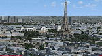
City of Paris - France v1.2 It's a photoreal seasonned scenery of the capital with new typical autogen, a bunch of buildings and monuments, trafic, etc. It covers about 140 km2 and also includes suburbs towns in the west, and the business area of "La Defense". It's apparently compatible with Prepar3D.
| Filename: | City_of_Paris__France.zip |
| License: | Freeware |
| Added: | 15th September 2016, 12:32:19 |
| Downloads: | 2,184 |
| Author: | marc-henri Guitteny |
| Size: | 417.86 MB |
| Category: Flight Simulator X - Scenery | |
| RAF Bircham Newton - Norfolk, England |
|
File Description:
RAF Bircham Newton is a former Royal Air Force station located 2.1 miles (3.4 km) south east of Docking, Norfolk
and 13.4 miles (21.6 km) north east of King's Lynn, Norfolk, England.
The site was first used during the First World War and received the largest British bomber of the time, the Handley Page V/1500. They would have carried out bombing missions against Berlin but the Armistice was arranged before any missions were actually flown.
The airfield was equipped with one aircraft repair shed and three double bay general service sheds, although these had been demolished by 1937. It had two Belfast hangars, three C Type hangars, three Bellman hangars and ten Blister hangars. It operated through the Second World War as part of No. 16 Group RAF as part of Coastal Command.
No. 206 Squadron RAF was one of the squadrons being based there, on maritime patrol duties. Two satellite airfields, RAF Docking and RAF Langham were opened to accommodate units. In 1965 the airfield was used for evaluation trials of the Hawker Siddeley Kestrel V/STOL aircraft.
After closure as an operational airfield in 1966, the airfield became the home of the Construction Industry Training Board. The runways have gone, but the majority of buildings on the site, including some hangars and the control tower, remain in use by the CITB.The control tower was demolished in 2010 due to its poor condition. Constructionarium is also based within the estate, providing a week's practical learning opportunity for undergraduates
| Filename: | RAF_Bircham_Newton__Norfolk_England.zip |
| License: | Freeware |
| Added: | 25th December 2015, 18:15:50 |
| Downloads: | 360 |
| Author: | Terry Boissel |
| Size: | 1.6 MB |
| Category: Flight Simulator X - Scenery | |
| Toulouse Blagnac (LFBO) v1 |
|
File Description:
This is an addon scenery for FSX of the Toulouse Blagnac Airport LFBO. It has been made using the excellent freeware tool Airport Design Editor for the layout. I have used Sketchup from Google and Model Converter X to design the buildings of the airport.
You will find all the terminals of LFBO and the control tower, as well as the Airbus facilities of the A380 Lagardere plant North East of LFBO, the A380 delivery center Henry Ziegler North West of LFBO, and some buildings of the Airbus facilities in Blagnac, West of LFBO. All buildings have photo textures, most of them taking with my camera, as I am working in the area. All buildings include night textures. You have two landing pads for helicopters like in reality South East of LFBO.
I used google earth for some items position, but the current view not being up to date, I used my knowledge of the area to correctly position the taxiways, parkings, gates and building position.
I used the FSX generic buildings for the other missing buildings, however they have the size and position which corresponds as far as possible to the position of the real buildings. The surroundings of the airport not being too realistic with Ultimate Terrain X or with FSX, I have modified the landclass of the surroundings to make them look more in accordance with reality. I have changed the parking assignment to make sure that the usual traffic will park on the parkings E, F D AB, V and U.
| Filename: | Toulouse_Blagnac_LFBO_v1.zip |
| License: | Freeware |
| Added: | 21st December 2011, 13:09:29 |
| Downloads: | 23,244 |
| Author: | Jose Mauriz |
| Size: | 34.72 MB |
| Category: Flight Simulator X - Scenery | |
| Amsterdam Schiphol - EHAM Netherlands Package |
|
File Description:
This Airport package is being released in conjunction with the release of the new ADE Design Utility (Airport Design Editor) to illustrate the power and design capabilities of both the current Home Version and the future Pro Version. The main airport in my ADE BGL is the Amsterdam Schiphol EHAM Airport. I also included into the single Airport Facility data bgl 5 additional airports which are Eindhoven AB (EHEH), Groningen Eelde (EHGG), Lelystad (EHLE), Maastricht-Aache (EHBK) and Rotterdam (EHRD) for you to explore. Major key changes are all 3 parallel runways are open with restrictions and are ATC controlled Arrival runways for both the User and AI Plane Traffic. Additional runways are also working simultaneously but some runways are closed for Arrival and/or Departure as per the ATC Preferential Runway System. All Gates and Parking Spots have been updated so AI Airline Planes, Maintenance, Cargo, Commuter, and Corporate GA park in the correct places. New Approach code including the 3 STAR's, Night RNAV's and all current Transitions have been rewitten and coded properly as seen in the GPS receiver per current Jeppesen Charts. Many Scenery features have also been added at each of the Airports which also includes the new H Terminal at EHAM. AI Planes fly the true RWY 24 VORDME curved approach from the PAM VOR and RWY 04/22 is a restricted runway that FSX ATC will only vector AI/User Planes that weigh less then 74000lbs EW to this active runway. Read the included Whats New Readme txt file for all the added enhancements.
| Filename: | Amsterdam_Schiphol__EHAM_Netherlands_Package.zip |
| License: | Freeware, limited distribution |
| Added: | 4th December 2007, 12:15:13 |
| Downloads: | 45,406 |
| Author: | Jim Vile |
| Size: | 4.27 MB |
| Category: Flight Simulator X - Scenery | |
| RAF Balderton |
|
File Description:
RAF Balderton is a former Royal Air Force station located 2.0 miles (3.2 km) south of Newark-on-Trent, sandwiched between the now extinct Great Northern Railway (GNR) Bottesford-Newark line and the A1 road in Nottinghamshire, England.
Opened in 1942, it was used by both the Royal Air Force and United States Army Air Forces. During the war it was used primarily as a troop carrier transport airfield and after for munitions storage before it was closed in 1957.
With the facility released from military control, Balderton was returned to agriculture, the runway concrete disappearing as hardcore under the AI road improvements of the 1960s. At that time, the developed Al was routed west of the original road, over the eastern perimeter track of the airfield, before coming back to the east to bypass Balderton village and Newark.
Gypsum open-pit mining has also taken its toll where quarrying has completely obliterated the airfield, with single track roads all that remain of the runway and perimeter track, and the occasional concrete runway end or pile of rubble.
Today the remains of the airfield are located on private property being used as agricultural fields.
| Filename: | RAF_Balderton.zip |
| License: | Freeware |
| Added: | 17th February 2016, 23:32:44 |
| Downloads: | 233 |
| Author: | Terry Boissel |
| Size: | 759.04 KB |
| Category: Flight Simulator X - Scenery | |
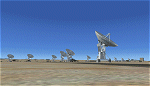
| NRAO - Karl G. Jansky Very Large Array |
|
Images related to this file:
File Description: The VLA or "Jansky Array", managed by the National Radio Astronomy
Observatory (NRAO) consists of 27 independent radio telescope dishes, each with
a diameter of 82 feet and weight of over 200 tons. Each antenna is found along
the three arms of a track shaped in a Y configuration measuring 13 miles long.
Using the rail tracks that follow each of these arms the antennas can be
physically relocated to a number of prepared positions. At one point, the arms
intersect with U.S. Route 60 which passes right through the middle of the array.
It has been featured in numerous films, such as Armageddon, Independence Day,
Terminator Salvation, a Bon Jovi music video, and was featured most prominently
-and correctly- in the Carl Sagan novel Contact, as well as the film of the same
name. Also updated is the closest airport to the VLA - Magdalena, NM - N29. It's
a small dirt strip a few miles to the east, between Socorro and the VLA. It
serves as a nice staging area for flights to the VLA. Includes a helipad startup
location with NM99 ident. Scenery by Jason L. Terry. For FSX Acceleration.
| Filename: | NRAO__Karl_G_Jansky_Very_Large_Array.zip |
| License: | Freeware |
| Added: | 23rd August 2014, 11:18:02 |
| Downloads: | 409 |
| Author: | Jason L. Terry |
| Size: | 3.18 MB |
© 2001-2026 AVSIM Online
All Rights Reserved
Privacy Policy |