
Where Flight Simulation Enthusiasts Gather from Around the World!
AVSIM Library - Search Results

| Category: Flight Simulator X - Scenery | |
| TACAN Replacements, Waypoints & Routes - UK Modern |

|
File Description:
By default, all of the TACAN navigational aids present within FSX have the bearing component turned off, so as to properly represent the real world result of tuning in the DME component of a TACAN with a civilian plane. However, this limits their functionality when you wish to use them in conjunction with a plane (generally military) equipped with a representation of a functioning TACAN system.
This download contains replacements for all of the currently active TACAN ground stations present in the UK, along with custom TACAN route waypoints as well as UK MIL AIP documentation and maps. These allows the user to fly the TACAN routes as per real world operations, as well as use TACAN approach charts.
| Filename: | TACAN_Replacements_Waypoints__Routes__UK_Modern.zip |
| License: | Freeware |
| Added: | 5th June 2014, 05:36:11 |
| Downloads: | 492 |
| Author: | Jim Stewart |
| Size: | 632.35 KB |
| Category: Flight Simulator X - Scenery | |
| YCVS Cervantes, Western Australia (Airstrip and Town) |
|
File Description:
Cervantes, Western Australia is located 247kms north of Perth and is the gateway to Australia's Coral Coast. Established in 1962 and named after an American whaling ship wrecked off the coast in 1844, Cervantes is a small but growing fishing town. Cervantes is also in close proximity to the Nambung National Park and the Pinnacles Desert. Many families from Perth enjoy the close proximity of Cervantes to Perth for weekend getaways. Now that the tourist road, Indian Ocean Drive has opened, Cervantes, Jurien and Leeman, once isolated fishing spots will become more prominent on the map. REQUIRES Blencowe_LibraryKit.zip
REQUIRES blencowe_librarykit_309494.zip (Available HERE)
| Filename: | YCVS_Cervantes_Western_Australia__Airstrip_and_Tow.zip |
| License: | Freeware |
| Added: | 25th February 2013, 09:04:38 |
| Downloads: | 274 |
| Author: | Alan Blencowe |
| Size: | 1.88 MB |
| Category: Flight Simulator X - Scenery | |
| Questa, New Mexico |
|
File Description:
Questa, New Mexico Scenery - N24 (FSX).
This is a fictitious rendition of the actual airport in Questa, New Mexico USA - N24.
http://en.wikipedia.org/wiki/Questa. -
http://www.acukwik.com/airportinfo/KN24.
I took a boring airport and added some "eye-candy" in order to have something nice to look at in addition to the spectacular mountains.
I created this for my own use but thought I would share it. This is the Third scenery creation of my New Mexico Small Airport series.
This is freeware. I hope you enjoy it.
Designed with the FS X Sdk Scenery function of the Mission builder and the Abacus Scenery shortcut tool.
This scenery is frame rate friendly.
| Filename: | Questa_New_Mexico.zip |
| License: | Freeware |
| Added: | 24th January 2007, 16:05:05 |
| Downloads: | 582 |
| Author: | Bob Caparoula |
| Size: | 2.02 KB |
| Category: Flight Simulator X - Scenery | |
| CYUL - TSC Building Logo - FIXED |
|
Images related to this file:
File Description:
![]()
For owners of Blueprint Simulations CYUL Scenery, this will place Air Transat's logo on their maintenance building.
That building is very recognisable due to the logo, which is in proximity of Highway 13, which sees a lot of traffic. The most used approach at CYUL is 24R,and this building is located right next to it, so it will give you an even better feel that you are about to touch ground in Montreal!
Fixed the file, as i had zipped a wrong file. put CYUL_TSC_LIB.BGL instead of CYUL_TSC_LOGO.BGL.
It now works.
NOTE: This file does not alter Blueprint's files, it is completely separate, but must be put in Blueprint's CYUL directory to work. Enjoy!
| Filename: | CYUL__TSC_Building_Logo__FIXED.zip |
| License: | Freeware |
| Added: | 26th January 2010, 04:14:58 |
| Downloads: | 951 |
| Author: | Brian Paquette |
| Size: | 666.14 KB |
| Category: Flight Simulator X - Scenery | |
| KBHB - Hancock County-Bar Harbor - Maine, USA |
|
Images related to this file:
File Description:
FSX Scenery - Hancock County-Bar Harbor Airport (IATA: BHB, ICAO: KBHB, FAA LID: BHB) is a county owned, public use airport located in Trenton, Maine, eight nautical miles (9 mi, 15 km) northwest of the central business district of Bar Harbor, a city in Hancock County, Maine, United States. It serves the residents of Hancock County with commercial and charter aviation services. During the summer months, the airport becomes one of Maine's busiest, with significant private jet operations bringing visitors to the numerous summer colonies in the county. THIS PACKAGE FIXES THE BLACK OBJECTS PROBLEM FROM THE PREVIOUS RELEASE. Scenery built by John B Loney Jr. Frame rate enhanced by Bob Lacy.
| Filename: | KBHB__Hancock_CountyBar_Harbor__Maine_USA.zip |
| License: | Freeware, limited distribution |
| Added: | 7th May 2015, 21:58:36 |
| Downloads: | 853 |
| Author: | John B. Loney, Jr |
| Size: | 24.83 MB |
| Category: Flight Simulator X - Scenery | |
| Winter Haven, FL Gilbert Airport (KGIF) and Jack Browns Seaplane School (F57) |
|
Images related to this file:
File Description:
Winter Haven's Gilbert Airport is somewhat unique in that it adjoins Jack Browns Seaplane School on Lake Jessie. The airport serves as a fly-in location for the nearby Lakeland Sun N' Fun airshow where camping is allowed under aircraft wings on the apron.
Scenery in this package is based on Virtual Earth (Bing) and Google Earth imagery. Gilbert Airport includes a new GA terminal and apron and is connected with a taxiway to Jack Browns Seaplane School. Ramps from the water to the apron at Jack Browns are also included. Landclass changes, roads, rework of taxiways and aprons, placement of library objects and a library of new airport buildings are included.
| Filename: | Winter_Haven_FL_Gilbert_Airport_KGIF_and_Jack_Brow.zip |
| License: | Freeware |
| Added: | 9th May 2010, 08:29:56 |
| Downloads: | 907 |
| Author: | Art Poole |
| Size: | 759.09 KB |
| Category: Flight Simulator X - Scenery | |
| "Hubballi Airport - VOHB, India V1" |
|
File Description:
Hubballi Airport (IATA: HBX, ICAO: VOHB) is a domestic airport serving the twin cities of Hubballi and Dharwad in the state of Karnataka, India. It is situated on Gokul Road, 8 kilometres from Hubballi and 20 kilometres (12 mi) from Dharwad. A new ATC tower, technical block, fire station, a new apron for parking 3 aircraft, a 12.8 km. security wall with 17 security watch towers and a sewage treatment plant were constructed and inagurated on 12 December 2017.Presently, the old terminal building and the apron is being converted to handle cargo flights. Hubballi Airport is 3rd busiest airport in Karnataka and 45th busiest airport in India (as of 2019). Tested with FSX only.
| Filename: | Hubballi_Airport__VOHB_India_V1.zip |
| License: | Freeware |
| Added: | 12th May 2020, 02:15:16 |
| Downloads: | 242 |
| Author: | Anvesh Bhat |
| Size: | 5.05 KB |
| Category: Flight Simulator X - Scenery | |
| Utah Complete v1.0 with Salt Lake City International Airport (KSLC) Scenery |
|
File Description:
This download includes Utah Complete v1.0 with my Salt Lake City International Airport Scenery. Utah Complete is a widespread project covering much of the state of Utah. This scenery upgrades the landscape, adds many scenery objects, improves many Utah airports, corrects flaws in default scenery, adds ski trails at ski resorts, enhances terrain in select locations, and provides an overall more realistic experience. In addition, Salt Lake City International Airport (KSLC) has been significantly improved with new custom GMAX buildings (including the terminal complex), updated AFCAD, and more realistic object placement. Other airports featured include: Provo (KPVU), Ogden (KOGD), St. George (KSGU), Logan-Cache (KLGU), Heber Valley (36U), Cedar City (KCDC), Moab (KCNY), Vernal (KVEL), and more!
| Filename: | Utah_Complete_v10_with_Salt_Lake_City_Internationa.zip |
| License: | Freeware, limited distribution |
| Added: | 19th September 2007, 00:44:01 |
| Downloads: | 16,739 |
| Author: | James Udall |
| Size: | 4.19 MB |
| Category: Flight Simulator X - Scenery | |
| EGLC - London City Airport |
|
Images related to this file:
File Description:
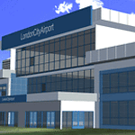
Scenery for FSX sp2 and Acceleration Pack.
Airport is located in London,on a former Docklands site in the London Borough of Newham, some 6 NM (11 km; 6.9 mi) east of the City of London and a rather smaller distance east of Canary Wharf. These are the twin centres of London's financial industry, which is a major user of the airport. The airport was developed by the engineering company Mowlem in 1986-87.
London City Airport has a single 1,500-metre (4,900 ft) long runway.Only multi-engine, fixed-wing aircraft with special aircraft and aircrew certification to fly 5.5° approaches are allowed to conduct operations at London City Airport.
| Filename: | EGLC__London_City_Airport.zip |
| License: | Freeware, limited distribution |
| Added: | 7th August 2014, 10:02:18 |
| Downloads: | 8,655 |
| Author: | Ashish Singh |
| Size: | 46.38 MB |
| Category: Flight Simulator X - Scenery | |
| Dupont airfield New Jersey |
|
Images related to this file:
File Description:
Presenting Dupont Airport in Delaware for FSX.
This scenery was done by request of Anthony Necastro, a good friend of ours on our Skype 'family' of friends,who often flew out of this airfield.
This airfield closed circa 1958. Lindberg landed here once. There are a number of planes needed for the traffic files. These are in a separate zip called Dupont-traffic-planes.zip.
If you install those also, you will see a good number of planes taking off around 12 noon. One or two go around and land again. Others go to New Castle a short distance away, and return soon.
My e-mail is in this download for hlep or comments. Bob Lacy
| Filename: | Dupont_airfield_New_Jersey.zip |
| License: | Freeware |
| Added: | 26th April 2016, 00:31:23 |
| Downloads: | 158 |
| Author: | Robert Lacy |
| Size: | 19.05 MB |
© 2001-2026 AVSIM Online
All Rights Reserved
Privacy Policy |