
Where Flight Simulation Enthusiasts Gather from Around the World!
AVSIM Library - Search Results

| Category: Flight Simulator X - Scenery | |
| Redtail Ridge Island Resort (AK94) |

|
File Description:
Redtail Ridge is a fictitious place in Alaska, but it's name is somewhat misleading as there is no ridges on the island. The airport boasts a 2300x45FT dirt runway, although it displays as a snow runway. There is also a 10000FT water runway, marked at each end with a red buoy. The airport is mainly intended as a place for the weary bush pilot to go and relax. There is a line of lakeside cabins to stay in, and there's even three little docks for floatplanes to tie up at. Also available are a selection of boats to rent, both sailboats and motorboats. For transportation around, there is a even a rental car angency. If the cabins are filled, stay in the hotel or sleep outdoors in the campsites. Go shopping at the mall or grab a bite to eat at the fast food joints. Anything you need to relax, you can find it here!
| Filename: | Redtail_Ridge_Island_Resort_AK94.zip |
| License: | Freeware |
| Added: | 2nd January 2008, 02:49:44 |
| Downloads: | 716 |
| Author: | Joe Brown |
| Size: | 5.2 KB |
| Category: Flight Simulator X - Scenery | |
| 2B3 Parlin Field, Newport, New Hampshire Airport |
|
Images related to this file:
File Description:
This airport was originally released as part of an FSX airport scenery package containing 21 airports, located in New Hampshire and Vermont. The link to the original 21 New Hampshire & Vermont Airport package is shown below. This file is not required, but allows you to download 21 related airports.
The 2B3 Parlin Field airport in the original 21 airport package was missing a required scenery file which corrects the airport altitude (from 784 ft. to 794 ft.) due to the mis-location of the stock FSX airport. This download provides all three of the required .bgl scenery files.
related download:
http://library.avsim.net/search.php?SearchTerm=new+hampshire+%26+Vermont+airports&CatID=root&Go=Search
This FSX scenery package contains the 2B3 Parlin Field airport in Newport, New Hampshire. This airport is intended to be used with FSX and the free addon - TileProxy. TileProxy provides real-time photorealistic satellite imagery in place of the stock auto generated FSX scenery or any other scenery package.
| Filename: | 2B3_Parlin_Field_Newport_New_Hampshire_Airport.zip |
| License: | Freeware |
| Added: | 2nd December 2013, 05:36:38 |
| Downloads: | 531 |
| Author: | John Greenwood |
| Size: | 631.59 KB |
| Category: Flight Simulator X - Scenery | |
| KMRY - Monterey Regional Airport - California, USA |
|
Images related to this file:
File Description:
FSX Scenery - Monterey Regional Airport (IATA: MRY, ICAO: KMRY, FAA LID: MRY) is three miles (5 km) southeast of Monterey, in Monterey County, California, USA. It was created in 1936 and was known as the Monterey Peninsula Airport until the board of directors renamed it on September 14, 2011. The airport is owned by the several municipalities that make up the Monterey Peninsula Airport District. It is a public entity and its five-member board of directors is publicly elected. The airport has its origins with flights from the polo field of the Hotel Del Monte in 1910. In 1941, local communities formed the Monterey Peninsula Airport District and acquired land to build an airport. World War II intervened, and the U.S. Navy leased the land, opening Naval Auxiliary Air Station Monterey on May 23, 1943. The Navy remained at the airport until 1972. For your flying pleasure by John B. Loney, Jr.
| Filename: | KMRY__Monterey_Regional_Airport__California_USA.zip |
| License: | Freeware, limited distribution |
| Added: | 5th June 2016, 12:11:50 |
| Downloads: | 590 |
| Author: | John B. Loney, Jr. |
| Size: | 39.38 MB |
| Category: Flight Simulator X - Scenery | |
| AI Ships and AI Ship Traffic US West Coast |
|
Images related to this file:
File Description:
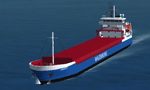
This file includes 4 new ships to supplement the ships available in my package "63 AI Ships and AI Ship Traffic for Europe and South America".
It also includes traffic files for the West Coast of the United States mainly from San Francisco and Oakland to the Strait of Juan de Luca, Tacoma, Seattle, and the Canadian cities of Victoria and Vancouver. A few routes go further South to Long Beach and San Diego. The traffic files utilize the new ships available in this update as well as the ships available in "63 AI Ships and AI Ship Traffic for Europe and South America" which must therefore be installed prior to this update.
The new ships are two small bulk carriers "Sardius" and "Andre W" and two large geared bulk carriers "Senorita" and "Carmencita" all done in GMAX. All ships have navigation lights, simple animations like rotating radars, and custom wake and smoke effects.
| Filename: | AI_Ships_and_AI_Ship_Traffic_US_West_Coast.zip |
| License: | Freeware |
| Added: | 30th March 2013, 23:18:57 |
| Downloads: | 10,998 |
| Author: | Henrik Nielsen |
| Size: | 2.47 MB |
| Category: Flight Simulator X - Scenery | |
| Avon Park Executive Airport Florida |
|
Images related to this file:
File Description:
Avon Park Executive Airport, Airport Code KAVO, is located in the
center of the Florida peninsula. It is within 80 miles of several major
Florida cities and International Airports including Tampa International
and Orlando International. Miami International is located about 150
miles SSE. Although used primarily by local businesses, it has repair
facilities for planes flown in for that purpose. In addition, it is
used as a temporary base for people attending the 12 Hours of Sebring
Gran Prix auto race as well as air shows held both at Sebring Regional
and Lakeland Linder airports.
The Terminal/Office building was created by me in Google Sketchup and
contains nothing from any other source. The windows are actual photos
taken of the building at the Avon Park Airport. I obtained permission
to use those photos from the Avon Park Executive Airport director. You
may use all or any part of this upload for any purpose that is legal.
| Filename: | Avon_Park_Executive_Airport_Florida.zip |
| License: | Freeware |
| Added: | 21st January 2013, 00:39:01 |
| Downloads: | 805 |
| Author: | Frank Watson |
| Size: | 2.08 MB |
| Category: Flight Simulator X - Scenery | |
| KORD-Chicago O'Hare 2018 |
|
File Description:
Chicago O'Hare 2018
===================
This airport has been undergoing frequent change ever since I first landed there in 2005. Fortunately, the core buildings have remained essentially the same, but runways have come and some have gone.
I got very close to releasing a 2016 version, but held back for more data. Then I looked again this year and discovered another runway gone, new ones in construction etc.
So, what I have decided to release is basically as up to date as I can make it, using Google Earth to judge the state of things in March 2018, and Charts from August 18th 2018. A lot of Taxiway labelling has changed yet again, and I dare say I've missed some of the taxi signs. One taxiway isn't on the March image, but is on the chart, so I've added it as best I can.
I think this will always be a work in progress.
| Filename: | KORDChicago_OHare_2018.zip |
| License: | Freeware |
| Added: | 20th August 2018, 15:50:08 |
| Downloads: | 1,774 |
| Author: | Martin Connor |
| Size: | 20.5 MB |
| Category: Flight Simulator X - Scenery | |
| YNUL Nullagine, Western Australia |
|
File Description:
YNUL Nullagine - Shire of East Pilbara with added ORBX textures. Nullagine is serviced by a gravel airstrip. This facility provides a vital air link. RFDS, Police, and local charter operators all rely on this airstrip for the provision of vital services to the communities. Nullagine is an old goldrush town in Western Australia's Pilbara region. It is located on the Nullagine River 296 km south-east of Port Hedland and 1,364 km north-north-east of Perth on the old Great Northern Highway. The town originated from gold being discovered in the area in 1886 by a prospector, N.W. Cooke. The population increased sharply as a result and by the mid 1890s the community wanted to have a town declared. Lots were surveyed and released in 1897 and the state government gazetted the town in 1899. Nullagine comes from the Aboriginal name of a nearby river, the Ngullagine river; the meaning of the word is unknown. Besides gold other minerals were mined in the area including diamonds and other gemstones. Between 1895 and 1914 the town boomed and contained a number of general stores, three hotels, eight stamp mills and a population of over 3,000. Its population was 1,500 prior to World War II. Now, with the decline of gold mining, only about 200 remain. However the town still attracts fossickers and prospectors who visit the surrounding area, which is particularly rich in minerals such as agate, asbestos, antimony, beryl, chalcedony, copper, jade, jasper, manganese, tiger eye and wolfram. The town is also the place of the Yirrangadji Aboriginal Community. The Martu people make up the bulk of this population. REQUIRES Blencowe_LibraryKit.zip
REQUIRES blencowe_librarykit_309494.zip (Available HERE)
| Filename: | YNUL_Nullagine_Western_Australia.zip |
| License: | Freeware |
| Added: | 28th February 2013, 14:00:15 |
| Downloads: | 292 |
| Author: | Alan Blencowe |
| Size: | 5.72 MB |
| Category: Flight Simulator X - Scenery | |
| RAF Gaydon - Warwickshie, England |
|
File Description:
RAF Gaydon (ICAO X3GY) is a former Royal Air Force station located 5.2 miles (8.4 km) east of Wellesbourne, Warwickshire and 10.8 miles (17.4 km) north west of Banbury, Oxfordshire, England.
RAF Gaydon opened in 1942 and is known for its role during the Cold War, when it was under the control of RAF Bomber Command as it was the first Royal Air Force (RAF) station to receive the Vickers Valiant when No. 138 Squadron RAF re-formed here in 1955.
In 1978, the site passed into civilian ownership and today contains the Heritage Motor Centre museum, the headquarters and factory of automobile manufacturer Aston Martin, and the Jaguar Land Rover Gaydon Centre. Source: Wikipedia.
| Filename: | RAF_Gaydon__Warwickshie_England.zip |
| License: | Freeware |
| Added: | 8th May 2016, 22:44:01 |
| Downloads: | 181 |
| Author: | Terry Boissel |
| Size: | 1.07 MB |
| Category: Flight Simulator X - Scenery | |
| RAF Waterbeach, Cambridgeshire 1943 |
|
File Description:
RAF Waterbeach (ICAO X3WH)is a former Royal Air Force station located in Waterbeach, Cambridgeshire which is 5.5 miles (8.9 km) north of Cambridge. The site was then used by the Royal Engineers, part of the British Army, from 1966, as Waterbeach Barracks until 2013 when the site closed to make way for housing. The site is currently unoccupied, apart from the officers' houses still in use - though Urban & Civic are now looking at temporary uses.
The airfield was built in 1940 on the northern edge of Waterbeach village and operated under the control of RAF Bomber Command. The original control tower and many RAF buildings, including several hangars, are still present
Source: Wikipedia
| Filename: | RAF_Waterbeach_Cambridgeshire__1943.zip |
| License: | Freeware |
| Added: | 11th May 2016, 20:27:00 |
| Downloads: | 143 |
| Author: | Terry Boissel |
| Size: | 1.34 MB |
| Category: Flight Simulator X - Scenery | |
| St KILDA upgrade for ORBX SCOTLAND |
|
File Description:
ST KILDA is an archipelago situated 41miles West of the Outer Hebrides.It is a world heritage site.
Its islands with their exceptional cliffs and sea stacks form the most important seabird breeding station in north-west Europe. The evacuation of its native population in 1930 brought to a close an extraordinary story of survival.
This scenery upgrades the ORBX scenery with the addition of -BORERAY Island and its two stacks (highest in the UK), Levenish, many birds, scenery added to HIRTA(the main island) and boat traffic.
Sadly no airfield but as Hirta has a military prescence there is a helicopter pad. This is an ideal place to explore with a floatplane!
| Filename: | St_KILDA_upgrade_for_ORBX_SCOTLAND.zip |
| License: | Freeware |
| Added: | 9th July 2017, 19:11:50 |
| Downloads: | 281 |
| Author: | john watts |
| Size: | 5.41 MB |
© 2001-2026 AVSIM Online
All Rights Reserved
Privacy Policy |