
Where Flight Simulation Enthusiasts Gather from Around the World!
AVSIM Library - Search Results

| Category: Flight Simulator X - Scenery | |
| SCIP - Isla de Pascua & Mataveri Intl - Easter Island |

|
Images related to this file:
File Description:
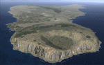
This project rebuilds Easter Island / Isla de Pascua. Mataveri Intl (SCIP) is completely overhauled, and all airport objects are aligned from satellite imagery. Landclass polygons and coastlines were meticulously hand-drawn directly from satellite imagery to provide the most detailed and accurate scenery available for this region. AI road and boat traffic is activated for the region. Accurate coastlines and road data, as well as corrected land and waterclass are provided based on the latest available satellite imagery. GA flights use default aircraft and include an option to add Chilean Air Force planes around the island. Numerous Moai (Easter Island heads) have been placed around the island according to satellite imagery. Scenery was created using Airport Design Editor X v1.61.5298, SBuilderX 3.13, and the FSX Object Placement Tool. Scenery objects were added and modified from stock FSX scenery to resemble as closely as possible the actual airports. The FSX apron lights included are from the terrific set created by Jim Dhaenens.
| Filename: | SCIP__Isla_de_Pascua__Mataveri_Intl___Easter_Islan.zip |
| License: | Freeware |
| Added: | 12th July 2014, 08:17:55 |
| Downloads: | 5,713 |
| Author: | Carlyle Sharpe |
| Size: | 5.33 MB |
| Category: Flight Simulator X - Scenery | |
| RAF Wickenby (1940s) |
|
File Description:
RAF Wickenby was a purpose built Royal Air Force station constructed late 1942 and early 1943 it had two T2 type
hangars and one B1 type. The B1 and one of the T2 hangars can still be seen on the airfield site. The T2 near the
threshold of runway 21 was recently acquired by the airfield owners and after many years of industrial use is now,
once more, an aircraft hangar.
The airfield covered about 600 acres (2.4 km2), and had the usual three runway configuration with perimeter track,
hard standings, a brick watchtower and numerous brick and metal buildings for the aircrews and ground staff. A number
of the buildings were to the east (Communal Site, Living Quarters, WAAF Quarters) and stretched to and beyond the
Lissington road - a road travelled many an evening by the airmen and women who visited their favourite watering hole,
the White Hart at Lissington. The Sick Quarters were to the south of the airfield together with a Communal Site and
Living Quarters.
The north part of the former airfield is now known as Wickenby Aerodrome, which is a grass and concrete airfield. A
road from Holton cum Beckering to Snelland runs right over the former airfield. Companies based at the airfield are
Thruster Aircraft who make microlight planes; Fly365 Ltd who fly pleasure flights; and Rase Distribution - a haulage
firm. Planes using the airfield have to make contact first with the control tower at RAF Waddington.
The Watch Office is the home of the RAF Wickenby Memorial Collection and the Wickenby Archive, a museum and collection
of memorabilia and archive dedicated to the memory of the Squadrons who served here.
| Filename: | RAF_Wickenby_1940s.zip |
| License: | Freeware |
| Added: | 10th March 2017, 14:46:25 |
| Downloads: | 136 |
| Author: | Terry Boissel |
| Size: | 15.14 KB |
| Category: Flight Simulator X - Scenery | |
| FSX - Barnstable Municipal Airport KHYA |
|
Images related to this file:
File Description:
FSX Scenery - Barnstable Municipal Airport (IATA: HYA, ICAO: KHYA, FAA LID: HYA), also known as Boardman/Polando Field, is a public airport located on Cape Cod, one mile (1.6 km) north of the central business district of Hyannis, in Barnstable County, Massachusetts, United States. This airport is publicly owned by the Town of Barnstable. It is Cape Cod's major airport as well as an air hub for the Cape and the Islands (Martha's Vineyard and Nantucket). The airport is served by scheduled commercial flights as well as charters and general aviation. This is a total re-do of my FS9 scenery. For you flight sim flying pleasure by John B. Loney, Jr.
| Filename: | FSX__Barnstable_Municipal_Airport_KHYA.zip |
| License: | Freeware, limited distribution |
| Added: | 19th March 2017, 18:23:44 |
| Downloads: | 668 |
| Author: | John B. Loney, Jr. |
| Size: | 36.46 MB |
| Category: Flight Simulator X - Scenery | |
| KBTR - Baton Rouge Metropolitan Airport - Louisiana, USA |
|
Images related to this file:
File Description:
Baton Rouge Louisiana Metropolitan Airport for FSX. Several improvements have been made to the default airport, including replacing the default terminal with new buildings modelled in FSDS, correctly numbering and coding gates using Airport Design Editor 1.67.5684, drawing new vehicle paths so as to prevent airport vehicles from accessing the taxiways, adding ample GA parking, changing the tower view to the roof of the control tower,and including the option of having all runways open to AI traffic. Also included are Jim Dhaenen's excellent ramp lights and a set of GA flight plans to liven up the GA area. Please read the README FIRST.txt and installation.txt files to insure proper installation of all files.
| Filename: | KBTR__Baton_Rouge_Metropolitan_Airport__Louisiana_.zip |
| License: | Freeware, limited distribution |
| Added: | 8th November 2015, 16:09:12 |
| Downloads: | 1,537 |
| Author: | Patrick Finch |
| Size: | 2.34 MB |
| Category: Flight Simulator X - Scenery | |
| RAF North Creake |
|
File Description:
RAF North Creake is a former Royal Air Force station located 3.3 miles (5.3 km) southwest of Wells-next-the-Sea, Norfolk and 5.7 miles (9.2 km) northwest of Fakenham, Norfolk, England.
Originally used in 1941 as a decoy site for RAF Docking, construction of this Class A airfield began in October 1942, with the station being provided with accommodation for 2,951 male and 411 female staff. The airfield had 36 loop type hardstandings, two T2 hangars and one B1 hangar.
By December 1943 the airfield had passed to 100 Group, although it did not immediately become operational as consideration was given to upgrading the airfield to Very Heavy Bomber Standard. In the event, this did not take place, with RAF Sculthorpe being selected for upgrade.
Short Stirling III's from 199 Squadron arrived in May 1944 to complete Window and Mandrel operations against enemy radar tracking of Bomber Command raids, however, in March 1945 these were changed to Handley Page Halifax III's. In September 1944, No. 199's 'C' Flight was used to re-form 171 Squadron, who contributed to 100 Group's radio counter-measures activities with Halifaxes.
The RAF relinquished the station in 1947, and the area is now used for agriculture, though some evidence of runways, buildings and facilities remains. Seventeen aircraft were lost from the airfield, eight Stirling's and nine Halifax's.
The control tower survives, and has been converted into a house, offering bed and breakfast.
Source: Wikipedia
| Filename: | RAF_North_Creake.zip |
| License: | Freeware |
| Added: | 13th February 2016, 12:50:51 |
| Downloads: | 237 |
| Author: | Terry Boissel |
| Size: | 1.73 MB |
| Category: Flight Simulator X - Scenery | |
| VFR Krakow for EPKK FSX&P3D |
|
Images related to this file:
File Description:
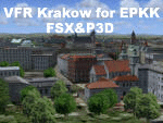
The Scenery "VFR Krakow for EPKK FSX&P3D" with an
extended area of the modeled city and with many new objects
and improvmends.
The old capital Krakow in Poland was modeled as an addon scenery
for FSX & P3D. This type of scenery recreates with very
reality a flight over a big city. The EPKK airport is
adjacent to Krakow.
This scenery covers the old part of Krakow with numerous
monuments and historical buildings, as well as the adjacent
districts with their buildings date from different architectural epochs.
Lot of castles and historical objects from the area around
the airport EPKK Balice were also modeled. The scenery included any
animations and moved shipings on the river Vistula (Wisla) and
vehical trafic in the modeled city.
Designer: Lotar Tomczyk, Jakub Mista
| Filename: | VFR_Krakow_for_EPKK_FSXP3D.zip |
| License: | Check within download |
| Added: | 16th February 2026, 12:46:38 |
| Downloads: | 70 |
| Author: | L. Tomczyk, J. Mista |
| Size: | 173.43 MB |
| Category: Flight Simulator X - Scenery | |
| Lsmp - Air Base Payerne Ver. 3 |
|
File Description:
The air base of Payerne is the principal one and the most important base of Switzerland. On this basis one finds 4 squadons. The squadons 17 and 18 which flight on F/A-18 Hornet. The squadon 6 which flies on F-5 Tiger. The squadon 1 which flies on Super Puma, Alouette 3, Cougar and all soon on lEC-635. This scene entirely compatible FSX SP1, SP2 and Pack Acceleration.
| Filename: | Lsmp__Air_Base_Payerne_Ver_3.zip |
| License: | Freeware |
| Added: | 14th January 2009, 14:40:35 |
| Downloads: | 5,910 |
| Author: | Alexandre Mugny |
| Size: | 5.36 MB |
| Category: Flight Simulator X - Scenery | |
| KPEO - Penn Yan Airport - Penn Yan, NY |
|
Images related to this file:
File Description:
Here is an improved version of the stock Penn Yan Airport. I adjusted aprons, taxiways and added roads to match the actual airport. I replaced every default building, added static vehicles, aircraft and other objects. Adjusted the boundary fence and made cuts where the fence crossed roads.
Penn Yan Airport is located on the shore of Keuka Lake, is owned by Yates County, and is home to Seneca Flight Operations.
| Filename: | KPEO__Penn_Yan_Airport__Penn_Yan_NY.zip |
| License: | Freeware |
| Added: | 7th December 2009, 10:37:29 |
| Downloads: | 603 |
| Author: | Jim Cook |
| Size: | 7.71 KB |
| Category: Flight Simulator X - Scenery | |
| Kaafcyte Island Strip, Kaafcyte, Nevada (NV03) |
|
File Description:
This scenery file is focused around the fictitious city of Kaafcyte, Nevada. Pretty much what I did was just started up the sim, found a little island, added an airport, and then placed a whole buncha scenery objects (80 in all) to depict a small city and airport. The airport has 2 runways, one paved and the other water, and some parking slots with a helipad. This is a good place to begin a bush flight to the adjacent mountains. The ciy includes a hospital, fire station, apartment buildings, a post office, a shoping center, fast food joints, homes, a power plant, power towers, phone poles, a port with crane, dock and static ships, campers, a hotel, and a conveinence store!
| Filename: | Kaafcyte_Island_Strip_Kaafcyte_Nevada_NV03.zip |
| License: | Freeware |
| Added: | 18th December 2007, 01:31:42 |
| Downloads: | 386 |
| Author: | Joe Brown |
| Size: | 5.12 KB |
| Category: Flight Simulator X - Scenery | |
| Slovenia - LOD11 (19 meters resolution) Mesh |
|
Images related to this file:
File Description:

Slovenia, no matter how small, is a country with wide variety of landscapes.
From flat lands in the North-Eastern part one can see lovely rolling hills in
southern regions and razor sharp edges of 8500 ft peaks of the Alps in the
North-Western region.
SRTM elevation data that was used and is provided as default FS X terrain simply
can't cope with the task of representing our terrain in at least a little close
to reality manner, shapes and altitudes of some of our nicest peaks are deformed
beyond recognition, our highest mt. Triglav is with 38 meters SRTM mesh falling
short by almost 3000 ft!
So Slovenia Scenery Team developed this 19 meters resolution using FSX compatible
tools for it's payware scenery, but after development of even finer mesh with 10
meters resolution, we decided to offer the original 19 meters mesh to general
fligt simulation public. Mesh is FS X only and is not compatible with FS9.
Even if released as freeware, this files were uploaded to only some selected
flight simulation sites and redistribution of this scenery is not allowed without
written permission from the authors.
File is packed into a convenient installer that should perform all of the actions
automatically, but, please, do read the License agreement and "Read me" file
included in the installation.
| Filename: | Slovenia__LOD11_19_meters_resolution_Mesh.zip |
| License: | Freeware, limited distribution |
| Added: | 15th May 2012, 19:03:19 |
| Downloads: | 2,214 |
| Author: | SST - Slovenia Scenery Team |
| Size: | 45.15 MB |
© 2001-2026 AVSIM Online
All Rights Reserved
Privacy Policy |