
Where Flight Simulation Enthusiasts Gather from Around the World!
AVSIM Library - Search Results

| Category: Flight Simulator X - Scenery | |
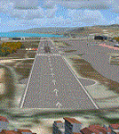
| Delta Heritage Air Park - CAK3 (FSX) |

|
File Description:
Known as "Delta" this is a PPS grass strip aerodrome situated south of Vancouver in Delta, British Columbia, Canada. The air park is well known for fly-ins breakfasts and numerous family activities. Formerly a farm in the 1960’s, the owner (a pilot) saw the growing need for those with small aircraft.
Delta has close to sixty aircraft that are stored in hangars or tied down on the grass. I have redone the entire airport according to available photos and satellite images. All objects are stock Autogen. If I owned a small aircraft this would be one of my favorite fields. Everyone here is very sociable. There are a lot of antiques at this site (Both fliers and aircraft).
VANCOUVER PLUS is required for this scenery to work.
| Filename: | Delta_Heritage_Air_Park__CAK3_FSX.zip |
| License: | Freeware |
| Added: | 16th April 2009, 05:05:18 |
| Downloads: | 707 |
| Author: | Will Jones |
| Size: | 1.56 MB |
| Category: Flight Simulator X - Scenery | |
| "The door of Paradise" China |
|
Images related to this file:
File Description:
I wanted to create this scenery of China titled "The Door of Paradise" near Zhangjiajie town, Hunan province, and on top of a mountain there is a striking thirty-meter-deep, deep arch rock-shaped cave , Which scales toward the sky. This unique, rocky rock formation seems to date back to the year 263, when - following a catastrophic event - the back of a cave collapsed leaving a hole in the wall and creating this striking panorama that the Chinese call "the symbol closest to God on earth. " I recommend that you leave Zhangjiajie ZGDY airport and reach the Tianmen Mountain coordinates N 29.03.24 E 110.28.58 where you can watch the door l Paradiso.
For more information on the site search on google. In the Package you will also find instructions for installing the scenery.
| Filename: | The_door_of_Paradise_China.zip |
| License: | Freeware |
| Added: | 17th August 2017, 17:19:37 |
| Downloads: | 752 |
| Author: | Pasquale Marrulli |
| Size: | 16.91 MB |
| Category: Flight Simulator X - Scenery | |
| Nomos Irakliou and Lasithiou |
|
Images related to this file:
File Description:
AS REAL AS IT GETS.
This is a detailed photo-realistic scenery of Nomos Irakliou and Lasithiou.
This upload is the last photo-scenery area containing airports in Greece.
Default FSX airports of Iraklio (LGIR), Sitia (LGST) and Kasteli (LGTL) were completely redone, positioned to their exact location, and many buildings and objects were added in the airport compounds.
New aprons, taxi signs and plenty of aircraft parking.
Also you have the choice of installing the textures of 22 original buildings (sketchup models) of the old Air Base near the town of Gouves. You could see the Base on your left at LGIR final runway 27.
The scenery contains plenty of autogen objects, buildings, vegetation and road traffic near the airports and the surrounding area.
I have also included 3 aircraft traffic files.
| Filename: | Nomos_Irakliou_and_Lasithiou.zip |
| License: | Freeware |
| Added: | 15th October 2011, 02:09:18 |
| Downloads: | 2,956 |
| Author: | Angelo Tassoglou |
| Size: | 245.12 MB |
| Category: Flight Simulator X - Scenery | |
| West Coast Victoria, Australia - 3 airports - YWBL Warrnambool YPOD Portland YPFA Port Fairy |
|
Images related to this file:
File Description:
West Coast Victoria includes 3 airports YWBL Warrnambool YPOD Portland YPFA Port Fairy. This scenery is the latest version of these airports which are (were) available as separate files. It is a major update/improvement with more detail plus improvements to Warrnambool recently added in the real world. Surrounding scenery modified to match real life. Local obstacles (towers etc) added. Included are AI traffic files for all 3 airports + YHML Hamilton nearby. Recommend installing the excellent YHML Hamilton (by Anthony Lynch). These files are for Flight Simulator X. Made using Airport Design Editor using some objects borrowed from Robert Budd's excellent Baccus Marsh. RECOMMENDED The scenery is designed to interface with ORBX FTX_AU scenery for Australia (payware). It will work without ORBX but will not interface as well with standard scenery.
| Filename: | West_Coast_Victoria_Australia__3_airports___YWBL_W.zip |
| License: | Freeware |
| Added: | 10th December 2018, 03:03:09 |
| Downloads: | 456 |
| Author: | Colin Jeffery |
| Size: | 1.68 MB |
| Category: Flight Simulator X - Scenery | |
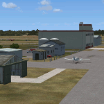
| MYAM - Marsh Harbour, Andros, The Bahamas |
|
Images related to this file:
File Description:

Marsh Harbour is the third busiest airport in the Bahamas, and now has a new runway, a new terminal, and the addition of a control tower and fire station. Completion of scenery for Marsh Harbour has been delayed since beginning work on the Bahamas' airports due to construction and a long delay in opening the new facilities, which occurred on May 27, 2014. There are currently no plans for opening the control tower, and it is not operational in this scenery. The scenery includes custom scenery objects, placement of library objects and landclass changes. Scenery is based on Google Earth and photos taken locally, and it is optimized for use with UTX-TAC. Some scenery details have changed from what is shown in screenshots included with the installation package.
| Filename: | MYAM__Marsh_Harbour_Andros_The_Bahamas.zip |
| License: | Freeware |
| Added: | 28th June 2014, 05:54:38 |
| Downloads: | 890 |
| Author: | Art Poole |
| Size: | 2.5 MB |
| Category: Flight Simulator X - Scenery | |
| Yeu island - LFEY |
|
Images related to this file:
File Description:
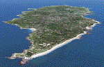
The island of Yeu (LFEY) is located in the west of France, in the south-west of Nantes. Its main runway is located on the wild coast, near the great lighthouse.
It is made up of :
- A new mesh based ASTER compiled in LOD11 and a very local mesh for the airport, compiled in LOD13 to get a good compatibility with the specific payware meshes.
- Photorealistic texture at 0.5 m/pixel based on aerial photography.
- The airfield and runway. The runway is flat, allowing to preserve the AI traffic. The grass strip is modeled with its relief. There is therefore no AI traffic on the grass strip.
- The port of Port-Joinville and several notable buildings made with Gmax (churches, chapel, castle, fort, ruins, beacons, etc)
- Generic or custom objects created with Gmax (boats, buildings).
| Filename: | Yeu_island__LFEY.zip |
| License: | Freeware |
| Added: | 29th December 2012, 04:03:47 |
| Downloads: | 1,718 |
| Author: | marc guitteny |
| Size: | 217.78 MB |
| Category: Flight Simulator X - Scenery | |
| CYGR and Ile de la Madeleine |
|
Images related to this file:
File Description:
The Magdalen Islands (in French, Iles de la Madeleine) form a small archipelago in the Gulf of Saint Lawrence. Though closer to Prince Edward Island and Nova Scotia, the islands are part of the Canadian province of Quebec.
There are eight major islands: Havre-Aubert, Grande Entree, Cap aux Meules, Grosse Ile, Havre aux Maisons, Pointe-Aux-Loups, Ile d'Entree and Brion. All except the latter are inhabited. There are several other tiny islands which are also considered part of the archipelago: Rocher aux Oiseaux, Ile aux Loups-marins, Ile Paquet and Rocher du Corps Mort.
This scenery include CYGR airport, hangar and terminal, static plane, Ile d'Entree runways, AI ships moving in this area, local harbours and fishing boats, new landclass definition and many authors's and default FSX objects populating islands.
| Filename: | CYGR_and_Ile_de_la_Madeleine.zip |
| License: | Freeware, limited distribution |
| Added: | 23rd December 2011, 18:14:40 |
| Downloads: | 4,112 |
| Author: | Pierre Gallant & Jean-Pierre Fillion |
| Size: | 11.96 MB |
| Category: Flight Simulator X - Scenery | |
| Ground Texture Upgrade |
|
File Description:
These new textures for FSX enhance your defualt ground airport textures. This package contains all new high detailed taxiway textures, ground textures, and all new taxiway line textures. The new ground textures give a more realistic illusion of rocks, grass, etc. Autogen as well as taxiways, will now look more realistice and "in place"since they are no longer over a low resolution detail 1.bmp file. The new taxiway line textures ( or taxilines as I call them) make your defualt taxilines look even more realistic. Now you will see enviromental weathering effects such as cracks and holes on the taxiline paint. And finally, the new taxiway textures upgrade the defualt FSX ones. Every detail, crack, and pebble was carefully analyzed and created with the aid of hi-res sources.
| Filename: | Ground_Texture_Upgrade.zip |
| License: | Freeware |
| Added: | 18th November 2006, 06:06:46 |
| Downloads: | 25,401 |
| Author: | Gamalier Padilla |
| Size: | 1.76 MB |
| Category: Flight Simulator X - Scenery | |
| 2 Fronson Hangars |
|
Images related to this file:
File Description:
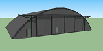
This model was created to be placed in FSX as airport scenery using Airport Design Editor.
I created it for my own use when i was re-creating RNAS HMS Nuthatch which was a Naval Airstation near Anthorn on the Solway Coast in Cumberland (now Cumbria), United Kingdom.
History of RNAS HMS Nuthatch...
Work began on building an airfield at Anthorn for the Fleet Air Arm in late 1943, with Royal Naval Air Station Anthorn, or HMS Nuthatch opening on 7 September 1944, with three tarmac runways.
It was the base of No. 1 Aircraft Receipt and Despatch Unit (No. 1 ARDU), which had the job of receiving aircraft fresh from manufacturers, modifying them to Service standards and despatching them to operational squadrons, with the unit specialising in the Vought F4U Corsair.
No. 1 ARDU continued to operate from Anthorn following the end of the Second World War, while a number of Fleet Air Arm Squadrons were also based at the airfield in the immediate post war years.
The airbase shut down in March 1958.
The Airfield is now the site of a VLF/LF transmitter used for transmitting orders to Submarines, it is also home to three atomic clocks for transmitting Britains time signal transmissions.
None of the Hangars (11 Pentad and 22 Fromson) survive at the site but their concrete standings are still visable.
Depicted here are representations of the Fromson type hangers created from dimensions in a 1947 survey.
I created the model using Google Sketchup and converted it for use in FSX using Model ConverterX.
This is my 1st attempt at scenery creation and is therefore pretty basic.
There are no known issues and it works fine in FSX.
| Filename: | 2_Fronson_Hangars.zip |
| License: | Freeware |
| Added: | 8th June 2014, 07:13:54 |
| Downloads: | 251 |
| Author: | Mark John Byers |
| Size: | 1.4 MB |
| Category: Flight Simulator X - Scenery | |
| Bartlett Village Alaska |
|
Images related to this file:
File Description:
Bartlett Village is just north of Bartlett Cove and created to make your flights to Bartlett Cove more fun. the water runway at Bartlett Cove points north directly at the Village float plane dock. There is also a helipad at the docks along with the Bartlett Village Inn. There are room rentals, cabin rentals, a small store near the docks for food, beverage and fishing supplies. The ACA, Alaska Conservation agency has a work camp on the island and there are two private residences, a light house on the SW end and other candies around the island. Gustavus has several new additions but no changes to the default configuration of the airport. If you fly around on the south west area of the island you may see a whale or two. Come by and visit. Read the readme and enjoy.
created by savageagle.
| Filename: | Bartlett_Village_Alaska.zip |
| License: | Freeware |
| Added: | 7th February 2010, 11:15:59 |
| Downloads: | 1,735 |
| Author: | Tim Durham |
| Size: | 640.35 KB |
© 2001-2026 AVSIM Online
All Rights Reserved
Privacy Policy |