
Where Flight Simulation Enthusiasts Gather from Around the World!
AVSIM Library - Search Results

| Category: Flight Simulator X - Scenery | |
| Dupont airfield New Jersey |

|
Images related to this file:
File Description:
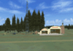
Presenting Dupont Airport in Delaware for FSX.
This scenery was done by request of Anthony Necastro, a good friend of ours on our Skype 'family' of friends,who often flew out of this airfield.
This airfield closed circa 1958. Lindberg landed here once. There are a number of planes needed for the traffic files. These are in a separate zip called Dupont-traffic-planes.zip.
If you install those also, you will see a good number of planes taking off around 12 noon. One or two go around and land again. Others go to New Castle a short distance away, and return soon.
My e-mail is in this download for hlep or comments. Bob Lacy
| Filename: | Dupont_airfield_New_Jersey.zip |
| License: | Freeware |
| Added: | 26th April 2016, 00:31:23 |
| Downloads: | 158 |
| Author: | Robert Lacy |
| Size: | 19.05 MB |
| Category: Flight Simulator X - Scenery | |
| Honduras Islands v3 |
|
Images related to this file:
File Description:
Version 3 includes all previous patches and updates. This version also restructures the file system to be fully compatible with the ORBX "FTX Global openLC North America" product as well as adding functionality for default FSX users. Additionally, water class scenery is updated to appear more realistic, MHRO is updated to reflect the newly expanded apron, and SRTMGL1 (30m) mesh is included. All landclass polygons and coastlines were meticulously hand-drawn directly from satellite imagery to provide the most detailed and accurate scenery available for this region.
This project rebuilds the islands of Roatán, Barbareta, Guanaja, and Utila, and adds Cayos Cochinos and the numerous cays associated with the "Islas de la Bahia" (Islands of the Bay). Roatán (MHRO), Guanaja (GJAJ/MHNJ) and Puerto Lempira (MHPL) are completely overhauled and positioning is corrected. New and fully functioning AI airports are added for Utila (MHUT), Fort Cay (MHFC) and Cochino Pequeño (MHCP) of the Cayos Cochinos chain, and La Ceiba (MHLC) is modified to accommodate more AI traffic. Accurate coastlines, lakes, road and river data, as well as corrected landclass are provided based on the latest available satellite imagery. GA flight plans are provided to add or enhance service to the smaller islands. Updates were created or rebuilt in a manner which carefully aligned airport data with current satellite imagery, when available. Scenery was created using Airport Design Editor X v1.70.6042, SBuilderX 3.13, and the FSX Object Placement Tool. Scenery objects were added and modified from stock FSX scenery to resemble as closely as possible the actual airports.
| Filename: | Honduras_Islands_v3.zip |
| License: | Freeware |
| Added: | 23rd December 2016, 08:17:26 |
| Downloads: | 1,608 |
| Author: | Carlyle Sharpe |
| Size: | 17.35 MB |
| Category: Flight Simulator X - Scenery | |
| FSX-LPMA-Funchal-Madeira |
|
File Description:
FSX-LPMA-Funchal-Madeira
well it starts as always, i can't find any usable freeware airport in this case for
the LPMA Madeira Funchal so I'll build it myself again...............well what can i
say here it is after a lot of work as real as possible with a lot of details with the
Default scenery built ..........So fly to Madeira with an Airbus A321 or a Boeing
737, of course There youchange to a heli or a smaller plane and see each other on
the premises at......
Installation:copy the folder LPMA-Madeira Scenery into the addon folder of the
FSX, start the FSX go to settings, scenery library , add area, press ok , after that
you can already start............
Extras:
to be able to see people I deliver the file 3DPeoble_Lib with you can also put it in
the Copy the addon folder and activate it in FSX as described during installation
and you'll see you people..............
the same applies to extra vehicles and extra buildings with the supplied files
ObjLib-Large-Car-Parking-FSX and you'll see more vehicles...........
Airport_Restaurants_ss_fsx.BGL + RCS_Cobus3000.BGL
! You don't need these extras if you already have them!
Extra bonus:
especially for the LPMA-Madeira, I'm adding the Airport AI Enhancer program so
that you can create your own AI traffic.........
more about it on my Youtube channel
https://www.youtube.com/channel/UC7vHXQMa3hhU2iGtODXlkHw/videos
Support:
Questions and help on my Youtube channel or by email to [email protected]
now have fun in Madeira Funschal
Jamaika
| Filename: | FSXLPMAFunchalMadeira.zip |
| License: | Freeware |
| Added: | 18th September 2022, 21:19:38 |
| Downloads: | 1,844 |
| Author: | Ewald Wagner |
| Size: | 71.29 MB |
| Category: Flight Simulator X - Scenery | |
| Mayaguana (MYMM) - The Bahamas |
|
Images related to this file:
File Description:
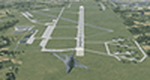
Mayaguana is the easternmost island in the Bahamas with Bahamasair providing Nassau and Inagua air connections. The airport utilizes part of an abandoned 11,000 foot USAF runway. The runway is listed as 7300 foot long, but 2400 feet on the east end is closed indefinitely. A new terminal building was completed, but no apron or taxiway connects it to the runway so it is unoccupied. Construction was started on another terminal, apron and taxiway as well as runway repaving, but the project is currently abandoned. All of the aforegoing is represented by this scenery. The scenery includes custom scenery objects; placement of library objects and landclass changes. Scenery is based on Bing Maps and photos taken locally, and it is optimized for use with UTX-TAC.
| Filename: | Mayaguana_MYMM__The_Bahamas.zip |
| License: | Freeware |
| Added: | 20th April 2013, 20:18:45 |
| Downloads: | 1,120 |
| Author: | Art Poole |
| Size: | 1.04 MB |
| Category: Flight Simulator X - Scenery | |
| channel ships |
|
File Description:
Ships, loads of ships in the English Channel (excusee: Pas de Calais)
About 60 ships (apart from ai ships)
When flying over the Channel, pilots say that an emergency landing here would certainly mean a crash into a ship; there are that many ships about.
You'll see Cargo ships, containerships, super tankers. Cruisliners are symbolic for the ferries sailing to and from Calais / Dover and Dunkirk.
Corrected for use with Ultimate terrain Europe
To be able to see this scenery I had to make a fake airport and named it LF00 (read: LF zero-zero)
There's a tower position as well, midways the channel with a height of 100 mtr. I haven’t tested it, it's not visible either.LF00 is visible in your GPS. Have fun.
| Filename: | channel_ships.zip |
| License: | Freeware, limited distribution |
| Added: | 12th January 2009, 13:00:36 |
| Downloads: | 3,771 |
| Author: | Joost Visser / ade1.37 |
| Size: | 134.43 KB |
| Category: Flight Simulator X - Scenery | |
| EPKS Poznan-Krzesiny AB Poland Scenery Package with AI Blk52+ CFT F-16s |
|
Images related to this file:
File Description:
This is a complete "plug and play" scenery package for EPKS Poznan-Krzesiny AB that includes two squadrons of "custom painted" Poland AF AI Block 52+ CFT F-16's!
Using Airport Design Editor, MAIW's Scenery Objects, and Google Earth for reference, I did my best to re-create EPKS Poznan-Krzesiny AB for FSX. Since info online about the base is limited, I had to guess about a few things, like taxiway designations and the frequency for the ILS, so apologies for any errors due to that. The 3-ELT and 6-ELT F-16s both have assigned parking in aircraft shelters, but I also created several other "assigned parking areas" around the base for you to add other AI aircraft as you wish.
| Filename: | EPKS_PoznanKrzesiny_AB_Poland_Scenery_Package_with.zip |
| License: | Freeware |
| Added: | 10th April 2022, 16:45:51 |
| Downloads: | 543 |
| Author: | Daniel W Gregory |
| Size: | 54.4 MB |
| Category: Flight Simulator X - Scenery | |
| EDTC Bruchsal |
|
Images related to this file:
File Description:
The airfield Bruchsal (ICAO: EDTC) is a special landing place in the city Bruchsal.
In addition to the use of the resident Luftsportverein Bruchsal, the place is also approved as a factory airfield of the company DG Flugzeugbau.
It has a grass runway: 12/30 - 500 by 30 metres (about 1,640 by 98 ft).
The scenery was created with a satellite picture of the airport, to match up all buildings, aprons, surroundings and so on, representing the most current state of EDTC as for the data that was available for the time the scenery got
created.
It contains ground textures for Summer and Winter (Spring/Fall use the Summer texture); autogen and default scenery objects of FSX plus a modified AFCAD file.
| Filename: | EDTC_Bruchsal.zip |
| License: | Freeware, limited distribution |
| Added: | 18th June 2018, 16:46:11 |
| Downloads: | 314 |
| Author: | Peregrine Simulations |
| Size: | 27.5 MB |
| Category: Flight Simulator X - Scenery | |
| YBWW - Brisbane West Wellcamp - Wellcamp, Australia |
|
File Description:
YBWW Brisbane West Wellcamp is Australia's newest airport and was privately built by Wagners Group. The Family had a dream so they built it. At the time of uploading QANTASLink (QLK16D, QLK15D, and QLK17D) are already flying direct to and from YSSY using the DH8D. REX are expected to commence using YBWW as a hub from January 2015. Wellcamp is located just west of Toowoomba in South Eastern Queensland. This is my first upload to AVSIM. It is not an extensive scenery, but provides enough to get operations started. There is nothing there is FSX, only a creek and farming land. I did this only because I couldn't locate one on the web for FSX. Credit to ADE and SBuilderX313, the two programs I used. Happy flying!
| Filename: | YBWW___Brisbane_West_Wellcamp__Wellcamp_Australia.zip |
| License: | Freeware |
| Added: | 24th November 2014, 19:31:41 |
| Downloads: | 819 |
| Author: | Sean Harrison |
| Size: | 4.51 KB |
| Category: Flight Simulator X - Scenery | |
| Quebec city 2.0 |
|
Images related to this file:
File Description:
Quebec city version 2.00 for Flight Simulator X.
FSX Scenery--Quebec City 2.0, Canada. Quebec city (Ville de Quebec in French) is the capital of the Canadian province of Quebec. This highly detailed scenery include more than 135 custom buildings. Come and see what Quebec City looks likes with its major landmarks in your flight simulator. Many new FSX features have been used to build this great scenery like animations and custom special effects. Also, see the CYQB airport scenery by Gilles Boily then enjoy flying in Quebec City. By Jean St-Cyr, Gilles Boily, Gilles Gauthier and Jean-Pierre Fillion.
This is and update version of Quebec city fsx scenery. Keep the first version since it is intended for low-end computers.
Thanks
Jean St-Cyr
| Filename: | Quebec_city_20.zip |
| License: | Freeware, limited distribution |
| Added: | 31st October 2009, 00:17:10 |
| Downloads: | 12,895 |
| Author: | Jean St-Cyr, Gilles Boily, Gilles Gauthier and Jean-Pierre Fillion |
| Size: | 65.2 MB |
| Category: Flight Simulator X - Scenery | |
| Laviolette bridge, Trois-Rivières, Québec Canada for FSX |
|
File Description:
The Laviolette bridge (in French, pont Laviolette) connecting the city of Trois-Rivières and Bécancour on the South shore of the Saint Lawrence River (Highway 55) is an important land mark for pilots flying between Montreal (CYUL) and Quebec City (CYQB). It is a beautiful and aesthetic arch bridge of 2.7km long with a main span of 335m and a total height of 106,6m
A lot of attention to details was required to reproduce the bridge complex structure. This scenery features a very accurate bridge with 4 lanes traffic, night textures, road lighting and static ships. Pilots are invited the take off from nearby CYRQ airport at the control of their favourite helicopter or slow aircraft to fly around the bridge to inspect the structure and appreciate the view.
| Filename: | Laviolette_bridge_TroisRivires_Qubec_Canada_for_FS.zip |
| License: | Freeware |
| Added: | 14th March 2008, 09:22:13 |
| Downloads: | 8,093 |
| Author: | Gilles Boily |
| Size: | 1.36 MB |
© 2001-2026 AVSIM Online
All Rights Reserved
Privacy Policy |