
Where Flight Simulation Enthusiasts Gather from Around the World!
AVSIM Library - Search Results

| Category: Flight Simulator X - Scenery | |
| YCDN Corunna Downs Station and Old Corunna Downs RAAF (Closed) |

|
File Description:
Corunna Downs heritage listed RAAF Base was a secret airfield located in scrub and spinifex country, about 16 kms south west of Marble Bar, the hottest part of the "The Pilbara" area of Western Australia. Not a very ideal place to have a tent city. Today there are very few reminders of the once busy airfield. One can see some crumbling foundations and half filled post holes. 73 OBU operated the Corunna Downs airfield which comprised two intersecting bitumen runways, now regressed and graded occasionally. One ran approximately north-south, 5,000 feet in length while the other ran approximately east-west, 7,000 feet in length. Both runways were approximately 150 feet wide. A 50 foot wide taxiway linked the northern end of the north-south runway to the western end of the east-west runway. Approximately 20 camouflaged revetments to disperse aircraft to minimise bomb damage were constructed at Corunna Downs. Permission is required for landing and there may be vegetation on the strip if not graded recently. No cones or windsock so be careful. Corunna Downs Homestead is also heritage listed and consists of graded strips and homestead complex. Start points are at the homestead and the RAAF base is to the west. REQUIRES Blencowe_LibraryKit.zip
REQUIRES blencowe_librarykit_309494.zip (Available HERE)
| Filename: | YCDN_Corunna_Downs_Station_and_Old_Corunna_Downs_R.zip |
| License: | Freeware |
| Added: | 25th February 2013, 08:59:42 |
| Downloads: | 283 |
| Author: | Alan Blencowe |
| Size: | 4.92 MB |
| Category: Flight Simulator X - Scenery | |
| Pichlingersee - LOW1 |
|
Images related to this file:
File Description:
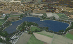
The Pichlingersee (LOW1) is a quarry pond near Linz (LOWL) in Austria (Upperaustria). The ILS approach to the runway 27 cross this lake. The helipad is in possession of Water Rescue Department and was not build on land. It was build "in water".
For the implementation of this area about 500 objects were set by hand from myself. Including not only trees and shrubs, but also signs, park benches, emergency call boxes (gernerated in gmax) etc at there right place. At night it was dark in real, so I does not create night texture. The scenery has 1.5 km ground imagery at 20cm per pixel and vary (hope) with the seasons.
Der Pichlingersee ist ein Baggersee in der Nhe von Linz (LOWL) in sterreich (Obersterreich). Der ILS Anflug auf die Landebahn 27 fhrt genau ber diesen See. Die Hubschrauberplattform gehrt der dortigen Wasserrettung und wurde nicht auf dem Land, sondern in den See hinein gebaut.
Fr die Umsetzung des Areals wurden von mir ber 500 Objekte von Hand gesetzt. Darunter nicht nur Bume und Strucher, sondern ebenso Schilder, Parkbnke, Notrufsulen (in gmax generiert) usw. an ihrem richtigen Platz. Da es dort in der Realitt nachts stockdunkel ist, habe ich auf Nachttexturen verzichtet. Die Szenerie hat eine 1.5 km Bodentextur mit 20cm/px und wechselt (hoffentlich) mit den Jahreszeiten.
| Filename: | Pichlingersee__LOW1.zip |
| License: | Freeware |
| Added: | 9th January 2013, 00:44:19 |
| Downloads: | 2,000 |
| Author: | Oliver Brandl |
| Size: | 54.71 MB |
| Category: Flight Simulator X - Scenery | |
| SKBO - El Dorado International Airport (2013) |
|
File Description:
El Dorado International Airport (IATA: BOG, ICAO: SKBO) is an international airport located in Bogota, Colombia. It is the largest Latin America airport in terms of cargo movements with 593,946 tons (2010) and the third in terms of
passenger traffic, only behind Sao Paulo-Guarulhos International Airport and Mexico City's Benito Juarez International Airport, transporting 18,934,203 passengers in 2010; as well as the largest airport in Colombia and the main
international and domestic air gateway in the country, serving as an important hub for Avianca, Copa Airlines Colombia, Aires, Satena, EasyFly and other cargo companies.
This file has the right coordinates, with the apron and characteristics of the airport with the new international terminal just builed in 2012. The runways were reoriented to the correct direction, runway were resized the gates placed on correct location and number, CATAM was placed
(Colombian Air force and Colombian National Army) and Colombia National Police and Colombian National Armada were assigned a correct apron. All the jet ways including the ones of the executive terminal are working. There is a copy
of all the airport charts required to navigate in and out of this airport which are courtesy of: Areonatica Civil de Colombia and the originals can be found at www.aerocivil.gov.co/ under Informacion Aeronautica click AIP; on AIP
click Aerodromos then click at SKBO.
This work is dedicated to West Wind Airlines.
| Filename: | SKBO__El_Dorado_International_Airport_2013.zip |
| License: | Freeware |
| Added: | 16th February 2013, 00:10:34 |
| Downloads: | 11,251 |
| Author: | Anwar Gonzalez |
| Size: | 19.16 MB |
| Category: Flight Simulator X - Scenery | |
| Eagle Field - Port Matilda, PA |
|
Images related to this file:
File Description:
Eagle field- 09PA Port Matilda PA.
Private Glider field Owned by Karl Striedieck. Karl is a world record setting glider pilot and a member of the U.S. Soaring Hall of Fame. He was an early pioneer of ridge soaring in the Ridge-and-valley Appalachians in the 1960s, ultimately setting nine world records flying gliders there. He was selected for the U.S. national soaring team 12 times, and won a silver medal in the world championships in 1978 and 1983.
Mr. Striedieck was a U.S. Air Force pilot from 1959 to 1962, flying the F-86 Sabre and F-102 Delta Dagger, then continued his military service until 1981 in the Pennsylvania Air National Guard, where he transitioned to the A-7 Corsair II. A year before graduating from Pennsylvania State University in 1965, he started flying gliders when he and Bill Clark co-founded the Nittany Soaring Club, flying out of the former State College Air Depot. He has over 15,000 flying hours, with nearly half of that total in gliders.
Mr. Striedieck moved his home to the Eagle Field private airport on top of Bald Eagle Mountain, near State College, Pennsylvania in 1966, and now lives there with his second wife, Iris.
Basically a manicured farm field, this private glider field offers access to the famous ridge lift of central Pennsylvania.Nearby Ridge Soaring is another one of my airfields available.
| Filename: | Eagle_Field__Port_Matilda_PA.zip |
| License: | Freeware |
| Added: | 11th June 2014, 16:30:28 |
| Downloads: | 324 |
| Author: | Jon Davidson |
| Size: | 16.52 MB |
| Category: Flight Simulator X - Scenery | |
| RAF Broadwell - Oxfordshire, England |
|
File Description:
RAF Broadwell (ICAO X2BW) is a former Royal Air Force station located 2 miles north of Broadwell and 3 miles southeast of Burford, Oxfordshire, within 2 miles of RAF Brize Norton.
It opened on 15 November 1943 and closed on 31 March 1947, operating under RAF Transport Command. It consisted of 3 concrete runways in triangular configuration.
Broadwell took part in the D-Day assaults with nearby RAF Down Ampney and RAF Blakehill Farm. Broadwell had two such squadrons, No. 512 Squadron RAF and No. 575 Squadron RAF were based here, flying the Douglas Dakota.
In February 1944, No. 512 Squadron was transferred to No. 46 Group at RAF Broadwell, it was a tactical Dakota squadron and started training glider towing and parachute dropping. Its first operation in the new role was a leaflet drop on 5 June 1944 over France, this followed intensive flying in and out of France including dropping parachutists at Arnhem.
On the eve of D-Day No. 575 Squadron dropped 5 Para into the invasion drop zone. On 6 June, it towed 21 Horsa gliders into France. In the next few weeks it started a casualty evacuation service from France back to England. In September 1944, it was involved in operation market garden to Arnhem where it suffered severe casualties.
The airfield continued to be a terminus for long-range transport operations to Europe, the Middle East and India. Source: Wikipedia
| Filename: | RAF_Broadwell__Oxfordshire_England.zip |
| License: | Freeware |
| Added: | 17th April 2016, 19:06:12 |
| Downloads: | 144 |
| Author: | Terry Boissel |
| Size: | 948.66 KB |
| Category: Flight Simulator X - Scenery | |
| LYBE Belgrade Nikola Tesla Airport |
|
File Description:
Belgrade Nikola Tesla Airport (IATA: BEG, ICAO: LYBE) is the primary international airport serving Belgrade, Serbia. Previously known as Belgrade International Airport, it was renamed in 2006 in honour of Serbian-American scientist and
inventor Nikola Tesla.
The airport is situated 12 km (7.5 mi) west, of central Belgrade, in the Surcin Municipality, surrounded by Syrmia's fertile lowlands. Passengers on the right hand side of planes descending from the east have a view of downtown
Belgrade, especially the districts of Cukarica and Novi Beograd. In 2008 the airport installed ILS CAT IIIb equipment to allow aircraft to land and depart in the heaviest of fog, which in past years led to numerous flight diversions
mostly in late December and early January.
The airport is owned and operated by the Public enterprise Aerodrom Nikola Tesla Beograd��. The company recorded profit of 21.5 million euros at the end of 2010.
The national flag carrier and largest airline of Serbia, Jat Airways, uses Belgrade Nikola Tesla as their main hub. It is also one of the hubs for low cost airline Wizz Air. Aviogenex charter airline, and air taxi airlines Air Pink,
Jat Airways AVIO taxi, Prince Aviation and Pelikan Airways also call the airport their home.
The airport charts are included.
This file has the right coordenates, with the apron and characteristics of the airport, airport vehicules and buildings, please take note the the gates numbers needed to changed: C1A= C11, C3A=C13, C5A=C15; general aviation parking
were added a extra number due to repetion on the numbers.
| Filename: | LYBE_Belgrade_Nikola_Tesla_Airport.zip |
| License: | Freeware |
| Added: | 8th November 2012, 03:32:04 |
| Downloads: | 8,849 |
| Author: | Anwar Gonzalez |
| Size: | 15.17 MB |
| Category: Flight Simulator X - Scenery | |
| RAF Wickenby (1940s) |
|
File Description:
RAF Wickenby was a purpose built Royal Air Force station constructed late 1942 and early 1943 it had two T2 type
hangars and one B1 type. The B1 and one of the T2 hangars can still be seen on the airfield site. The T2 near the
threshold of runway 21 was recently acquired by the airfield owners and after many years of industrial use is now,
once more, an aircraft hangar.
The airfield covered about 600 acres (2.4 km2), and had the usual three runway configuration with perimeter track,
hard standings, a brick watchtower and numerous brick and metal buildings for the aircrews and ground staff. A number
of the buildings were to the east (Communal Site, Living Quarters, WAAF Quarters) and stretched to and beyond the
Lissington road - a road travelled many an evening by the airmen and women who visited their favourite watering hole,
the White Hart at Lissington. The Sick Quarters were to the south of the airfield together with a Communal Site and
Living Quarters.
The north part of the former airfield is now known as Wickenby Aerodrome, which is a grass and concrete airfield. A
road from Holton cum Beckering to Snelland runs right over the former airfield. Companies based at the airfield are
Thruster Aircraft who make microlight planes; Fly365 Ltd who fly pleasure flights; and Rase Distribution - a haulage
firm. Planes using the airfield have to make contact first with the control tower at RAF Waddington.
The Watch Office is the home of the RAF Wickenby Memorial Collection and the Wickenby Archive, a museum and collection
of memorabilia and archive dedicated to the memory of the Squadrons who served here.
| Filename: | RAF_Wickenby_1940s.zip |
| License: | Freeware |
| Added: | 10th March 2017, 14:46:25 |
| Downloads: | 136 |
| Author: | Terry Boissel |
| Size: | 15.14 KB |
| Category: Flight Simulator X - Scenery | |
| YFRV Oombugurri Community, Western Australia (Town closed 2011) |
|
File Description:
YFRV Oombugurri Community, Western Australia, formerly Forrest River Mission. Features extensive flattening of Forrest River which runs uphill. Take a flight there before installing the scenery.
Oombulgurri, was an Aboriginal community in the eastern Kimberley, 45 kilometres southeast of Wyndham.
The Anglican Forrest River Mission for Aborigines was founded in 1896���¢������97 by Harold Hale (Later Bishop of Prth) but was abandoned after a few months. A permanent mission, known as the Forrest River Mission, was established on the site in 1913 by the bishop of the north west, the Rt. Rev. Gerard Trower. In December 1913, Anglican priest Ernest Gribble took charge, three years after he was forced to resign as superintendent at Yarrabah. Gribble remained as superintendent until the early 1930s.
In 1926 the mission was plagued by an influenza epidemic and impacted by the Forrest River massacre where police killed a number of Aboriginal people. This event remains controversial.
The mission was closed in 1969, after the 1967 Aboriginal referendum.
In 1973, fifty Aboriginal people decided to resettle their abandoned tribal land and rename it Oombulgurri. Within a year, the population had grown to 200. Infrastructure and welfare programs were set up in the 1970s and 1980s to provide the residents with basic amenities and to allow the town to become self-sufficient.
In 2007 a Coronial Inquiry began into Aboriginal deaths in the Kimberley, including five in Oombulgurri. It revealed high levels of alcohol abuse, suicide and child neglect in Oombulgurri. Some time after the inquest, alcohol was banned there and the population began to move away to areas where alcohol was available.
It had a population of 107 as of the 2006 census. In 2011, the government of Western Australia encouraged residents of Oombulgurri to move elsewhere as it considered the community "unviable". The last residents from Oombulgurri were relocated to Wyndham just before Christmas 2011. REQUIRES Blencowe_LibraryKit.zip
REQUIRES blencowe_librarykit_309494.zip (Available HERE)
| Filename: | YFRV_Oombugurri_Community_Western_Australia_Town_c.zip |
| License: | Freeware |
| Added: | 28th February 2013, 02:37:06 |
| Downloads: | 229 |
| Author: | Alan Blencowe |
| Size: | 2.97 MB |


© 2001-2026 AVSIM Online
All Rights Reserved
Privacy Policy |