
Where Flight Simulation Enthusiasts Gather from Around the World!
AVSIM Library - Search Results

| Category: Flight Simulator X - Scenery | |
| Mid West Victoria UPDATED. 14 airports. YARA YSWL YMBU YSTA YDOD YWYF YBIR YHPN YKER YSLK YSWH + *NEW* YNHL YHML YWKB |

|
Images related to this file:
File Description:
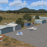
This is an updated version (original Jan 2018). Fixed some ground texture problems plus a lot of added and improved objects and 3 NEW airports. There are 14 airports starting at Ararat and extending up to the Murray at Swan Hill. YARA Ararat YSWL Stawell YMBU Maryborough YSTA Saint Arnaud YDOD Donald YWYF Wycheproof YBIR Birchip YHPN Hopetoun YKER Kerang YSLK Sealake YSWH Swanhill + *NEW* YNHL Nhill YHML Hamilton YWKB Warracknabeal. A lot of airports but not a quicky slap dash effort. It is several hundred hours over many months. Surrounding scenery modified to match real life. Towns, race courses, forests, sewage treatment ponds, obstacles (towers etc) have been added. Included is an AI traffic file that covers all airports that don't already have AI. These files are for Flight Simulator X. Made using Airport Design Editor using some objects borrowed from Robert Budd's excellent Baccus Marsh. RECOMMENDED The scenery is designed to interface with ORBX FTX_AU scenery for Australia (payware). It will work without ORBX but will not interface as well with standard scenery.
| Filename: | Mid_West_Victoria_UPDATED_14_airports_YARA__YSWL__.zip |
| License: | Freeware |
| Added: | 16th May 2019, 18:19:35 |
| Downloads: | 419 |
| Author: | Colin Jeffery |
| Size: | 5.23 MB |
| Category: Flight Simulator X - Scenery | |
| Area 51 V1.1 |
|
Images related to this file:
File Description:
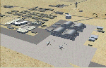
In V1 I added tower comms, taxiways/signs, and deleted start points for all those dirt & other closed runways and made the primary/secondary 14/32.
In V1.1 I have gone through the rest of the airport, aligning and cleaning up scattered oddly placed buildings and placed them in a logical manner - aligned with roads. with parking lots and/or pavement or concrete around their base. Gravel roads added thru the warehouses, sand maintenance roads to water tower and power station, Rec center pool and ballfield touched up. Fire station is in same place but turned towards flight line and added the trucks an ambulance. Fencing all around the flight line.
Also you get the F-117 and Janet 737 WITH traffic file. The Janet 737 is the shuttle aircraft for the Area 51 workers. Watch as the Janet flights arrive each morning from KLAS and depart each night Mon-Fri. KLAS (Las Vegas) Bgl also included with assigned parking at the Janet Terminal.
| Filename: | Area_51_V11.zip |
| License: | Freeware |
| Added: | 24th October 2014, 11:47:01 |
| Downloads: | 2,464 |
| Author: | Jeff Reed |
| Size: | 17.66 MB |
| Category: Flight Simulator X - Scenery | |
| YBIU Ballidu, Western Australia |
|
File Description:
YBIU Ballidu is a town located in the Wheatbelt region of Western Australia, about 217 kilometres (135 mi) north of Perth. The townsite was gazetted in 1914, with street names of the original settlers. A primary school opened in the town on 4 September 1922, moving into permanent premises in 1924. Ballidu has a population of less than 100 people and consists of Ballidu Primary School, the local Art Gallery, a hall, a few shops for groceries and essentials and several farming supply stores. As Ballidu is a farming region, over the years (as the size of the surrounding farms has increased), the town has become smaller and smaller.
This airfield is run by Dunn Aviation and mainly home for their Air Tractor and Dromadaire fleet. (I have created a low poly version beacuse its my first aircraft model). It has a windsock and hangar but little else.
REQUIRES blencowe_librarykit_309494.zip (Available HERE)
| Filename: | YBIU_Ballidu_Western_Australia.zip |
| License: | Freeware |
| Added: | 25th February 2013, 08:24:07 |
| Downloads: | 469 |
| Author: | Alan Blencowe |
| Size: | 2.76 MB |
| Category: Flight Simulator X - Scenery | |
| RAF Burn |
|
File Description:
The Station opened in 1942 before closing in 1946, it hosted No. 431 Squadron, Royal Canadian Air Force as part of 4 Group RAF Bomber Command which formed at the airfield on 13 November 1942 flying Vickers Wellington Mark X aircraft while at Burn. On 15 July 1943 the squadron was transferred to RAF Tholthorpe and became part of No. 6 Group RCAF.
On 1 January 1944 No. 658 Squadron RAF moved to the airfield from RAF Clifton flying the Taylorcraft Auster III but left only seven days moving to RAF Doncaster but on 21 January 1944 the squadron returned, this time staying until 14 March 1944 when they moved to RAF Collyweston. The squadron was briefly joined on 31 December 1943 by 659 Squadron which moved to RAF Clifton the following day.
During its use the airfield was also used by No. 10 Aircrew Holding Unit RAF.
On 6 January 1944 No. 578 Squadron RAF squadron was relocated to RAF Burn from RAF Snaith. This Bomber Command squadron flew Handley Page Halifax Mk. III before disbanding on 15 April 1945 and the station was closed for flying operations in July 1945.
On the night of 30 March 1944, Pilot Officer Cyril Joe Barton took off from RAF Burn in Halifax LK797 for a raid on Nuremberg, and won a posthumous Victoria Cross for valour.
Shortly after flying was discontinued, the Royal Army Service Corps took over some facilities to store surplus equipment. ] Many of the buildings have been dismantled but all three runways remain intact and are used by Burn Gliding Club Ltd.
Source:Wikipedia
| Filename: | RAF_Burn.zip |
| License: | Freeware |
| Added: | 26th March 2017, 19:29:21 |
| Downloads: | 113 |
| Author: | Terry Boissel |
| Size: | 185.28 KB |
| Category: Flight Simulator X - Scenery | |
| YMBE Mooliabeenie Siding, Western Australia (closed) |
|
File Description:
YMBE Mooliabeenie Siding is a disused 1,500 m (4,900 ft) long satelite airstrip which was used by the United States Army Air Corps during World War II and associated with the Caversham Airfield at Middle Swan. Like the Caversham Airfield, the Mooliabeenee Airfield was later used an auto racetrack. Local car clubs regularly use the site for motorkhana events. REQUIRES Blencowe_LibraryKit.zip
REQUIRES blencowe_librarykit_309494.zip (Available HERE)
| Filename: | YMBE_Mooliabeenie_Siding_Western_Australia_closed.zip |
| License: | Freeware |
| Added: | 28th February 2013, 13:56:01 |
| Downloads: | 195 |
| Author: | Alan Blencowe |
| Size: | 5.98 MB |
| Category: Flight Simulator X - Scenery | |
| KTTD - Portland-Troutdale Airport - Oregon, USA |
|
Images related to this file:
File Description:
Situated at the gateway to the Columbia River Gorge and one of the bases for Hillsboro Aviation's largest helicopter school in the Pacific Northwest, Troutdale Airport regularly endures winds in excess of 50 mph during the winter easterlies.
This version was made with adjusted photographic ground imagery and a custom ground polygon runway. The airport has many custom objects; lights with attached effects, buildings, aircraft and vehicles. Airport Design Editor and ModelConverterX were instrumental in producing this add-on.
| Filename: | KTTD__PortlandTroutdale_Airport__Oregon_USA.zip |
| License: | Freeware, limited distribution |
| Added: | 30th March 2014, 14:14:17 |
| Downloads: | 1,042 |
| Author: | Rick Keller |
| Size: | 120.75 MB |
| Category: Flight Simulator X - Scenery | |
| RAF Deopham Green - Norfolk, England |
|
File Description:
RAF Deopham Green is a former Royal Air Force station located near Deopham Green 2 miles (3.2 km) north of Attleborough, Norfolk, England.
| Filename: | RAF_Deopham_Green__Norfolk_England.zip |
| License: | Freeware |
| Added: | 13th January 2016, 22:18:16 |
| Downloads: | 208 |
| Author: | Terry Boissel |
| Size: | 1.18 MB |
| Category: Flight Simulator X - Scenery | |
| HideAways- - Blake Island |
|
File Description:
Blake Island , Washington.....You do a "LOW Flyover" to scope it out and make your decision...those rocks may be a problem you think to yourself........Once again you are approaching in your 172,with beads of sweat on your forehead and knuckles white as you grip the yolk , carefully nursing the rudders,
Wondering to yourself,"What the @#&* am I doing???"
This is a fictitious event.....just for the fun of it. ...This scenery has a " Pucker" factor of 9. :-O
| Filename: | HideAways__Blake_Island.zip |
| License: | Freeware |
| Added: | 11th June 2007, 23:32:23 |
| Downloads: | 819 |
| Author: | Jim Beall |
| Size: | 239.67 KB |
| Category: Flight Simulator X - Scenery | |
| CCS6 - Courtenay (Smit Field) |
|
File Description:
Courtenay Airport is located 2.5 Nm west of Courtenay on the beautiful Vancouver island, BC
It is actually a private airfield. It has been enhanced to accomodate up to 3 lights aircrafts. It is a short grass airfield and VFR conditions a must, specifically when inbound for Rwy 04 due to the ground layout.
I have added some visual reference you may use when inbound ;)...don't worry, you can't miss it! LOL
Hope youll have a good time in Courtenay Airport.
| Filename: | CCS6__Courtenay_Smit_Field.zip |
| License: | Freeware |
| Added: | 10th April 2009, 01:43:48 |
| Downloads: | 736 |
| Author: | Daniel Louvet |
| Size: | 3.03 MB |
| Category: Flight Simulator X - Scenery | |
| RAF Spilsby Airfield |
|
File Description:
RAF Spilsby, situated 3 miles E of Spilsby, 8 miles west of Skegness, in Lincolnshire, was a 5 Group Bomber Command station, opening in September 1943. Spilsby was home to 207 and 44 Squadron, flying Lancasters.
The airfield closed in November 1946, breifly reopening in the 1950's. Today the site is used for Agriculture.
No: 207 Squadron Oct 1943 to July 1945
No:44 Squadron Sep 44 to July 1945
No 2 Armament Practice School. July 1945 to Nov 1946
| Filename: | RAF_Spilsby_Airfield.zip |
| License: | Freeware |
| Added: | 18th March 2009, 13:41:54 |
| Downloads: | 403 |
| Author: | Chris Smith |
| Size: | 952.56 KB |


© 2001-2026 AVSIM Online
All Rights Reserved
Privacy Policy |