
Where Flight Simulation Enthusiasts Gather from Around the World!
AVSIM Library - Search Results

| Category: Flight Simulator X - Scenery | |
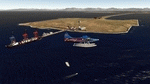
| KGTB - Wheeler-Sack AAF - Fort Drum, NY |

|
File Description:
Here is an improved version of the stock Wheeler-Sack AAF. I adjusted and added aprons, roads and
taxiways to more closely match real life. I added Military_combat and Military_cargo parking spaces.
I replaced most buildings and added additional buildings. I replaced and moved the control tower,
added the fire station, parking lots, static vehicles and helicopters, lightpoles, and other objects.
Fort Drum is home to the 10th Mountain Division and it houses an air-to-ground gunnery range which is
used by the 174th Fighter Wing of the NY National Guard out of Syracuse, NY.
| Filename: | KGTB__WheelerSack_AAF__Fort_Drum_NY.zip |
| License: | Freeware |
| Added: | 23rd April 2009, 06:48:06 |
| Downloads: | 902 |
| Author: | Jim Cook |
| Size: | 13.2 KB |
| Category: Flight Simulator X - Scenery | |
| Calhoun Memorial Alaska |
|
Images related to this file:
File Description:
Presenting PATA, Ralph Calhoun Memorial Airport. This is very close to Tanana, Alaska. This scenery is easy on frame rates. We now have here an Inuit fishing village, small terminal (look through the glass in front and to the left- my grandson!), train station, long train, street lamps at night with visible lights shinning to the ground, shipping and receiving building, Cafe, first aid center, fire station, both with trucks, refueling area that works. Readme file has the slider settings I use but these settings are not manidtory. Contact info in readme file. Navaids are stated and are stock. Bob
| Filename: | Calhoun_Memorial_Alaska.zip |
| License: | Freeware |
| Added: | 29th December 2011, 23:24:57 |
| Downloads: | 712 |
| Author: | Robert Lacy |
| Size: | 7.87 MB |
| Category: Flight Simulator X - Scenery | |
| Point Roberts Rail Depot |
|
Images related to this file:
File Description:
A small scenery adding many objects to the area near Point Roberts Airpark and Boundary Bay. Objects include small marinas, docks, vehicles, a cargo train, two elevated helipads and one ground level pad. There are many other objects that spruce up the area too. The main additions are at the two points west of the two airports mentioned and one on the shoreline close to Boundary Bay (south).
Has objects migrated from FS9 that work very well and was designed with Instant Scenery and FSX had no scenery enhancements of any kind. Created to enhance your flying experience. Enjoy! Savageagle.
| Filename: | Point_Roberts_Rail_Depot.zip |
| License: | Freeware |
| Added: | 28th August 2012, 19:25:45 |
| Downloads: | 373 |
| Author: | Tim Durham |
| Size: | 3.33 MB |
| Category: Flight Simulator X - Scenery | |
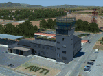
| KJYO - Leesburg Executive Airport - Virginia, USA |
|
Images related to this file:
File Description:

East Coast Simulations presents scenery for Leesburg Executive Airport (KJYO/JYO) for FSX/P3D! Leesburg Executive Airport at Godfrey Field (IATA: JYO, ICAO: KJYO, FAA LID: JYO) is a town-owned public-use airport located three nautical miles south of the central business district of Leesburg, a town in Loudoun County, Virginia, United States. It is a busy general aviation airport in the Washington, D.C. area, and a reliever for nearby Washington Dulles International Airport. This scenery includes all custom buildings and terminals with a season changing photoreal background. There are many custom ground polygons, and even 3-D PAPI lights are modeled.
| Filename: | KJYO__Leesburg_Executive_Airport__Virginia_USA.zip |
| License: | Freeware |
| Added: | 19th August 2015, 20:58:47 |
| Downloads: | 1,013 |
| Author: | Wesley Chin |
| Size: | 74.66 MB |
| Category: Flight Simulator X - Scenery | |
| Decimomannu Mil. |
|
Images related to this file:
File Description:
Decimomannu Mil. [Sardinia] Scenery for FSX / P3D also includes 'Capo Frasca' Weapons Range Scenery. 'Deci' [ICAO LIED] for FSX & P3D includes Buildings, Hangars, Gate Guards, Monuments, Ground Equipment, AFCAD, Tower View and Custom Lighting. The scenery includes the 'Pantograph' refuelling system which will automatically refuel your aircraft if you park adjacent to the equipment.
"Capo Frasca" Range Scenery includes Observation Towers, Targets, Radar Equipment and Main Entrance that are modelled as near as possible to the current 'real world' situation. An optional ILS system is included in the AFCAD to assist 'running in' on the two main target areas.
| Filename: | Decimomannu_Mil.zip |
| License: | Freeware |
| Added: | 12th March 2015, 23:29:31 |
| Downloads: | 3,638 |
| Author: | Dave Torkington & Guy Neild |
| Size: | 65.91 MB |
| Category: Flight Simulator X - Scenery | |
| Guernsey X-HD |
|
Images related to this file:
File Description:

Guernsey Airport is located on the island of Guernsey which is on of the few islands that make up the English Channel Islands. With a runway just shy of 1.6 kilometres this airports offers a challenging departure and approach for large aircraft.
Also, the island is small and unguarded from winds gusting through the English Channel so this adds to the challenge.
This scenery is provided with surrounding Photo-scenery for extra realism. it features High definition ground image and detailing, perfectly placed 3d objects overall a very nice bit of eye candy for your FSX world
| Filename: | Guernsey_XHD.zip |
| License: | Freeware, limited distribution |
| Added: | 4th February 2017, 20:01:56 |
| Downloads: | 2,770 |
| Author: | Mark Piccolo - Soarfly Concepts |
| Size: | 67.26 MB |
| Category: Flight Simulator X - Scenery | |
| KPBI - Palm Beach International Airport - Final |
|
Images related to this file:
File Description:
This is the completed version of scenery for KPBI previously uploaded to libraries as "Beta". The terminal area includes assigned airline gate
parking with moving jetways. All runways, taxiways, aprons, control tower, etc. have been brought up to date. The scenery includes custom
scenery objects and ground polys, placement of library objects and landclass changes. Scenery is based on Google Earth and Bing Maps Birds
Eye, and it is optimized for use with UTX. I find it flyable with low framerates on my computer with scenery complexity set to extremely dense, and
extensive WOAI airline traffic enabled to activate jetways.
| Filename: | KPBI__Palm_Beach_International_Airport__Final.zip |
| License: | Freeware |
| Added: | 22nd November 2014, 10:16:57 |
| Downloads: | 3,014 |
| Author: | Art Poole |
| Size: | 4.4 MB |
| Category: Flight Simulator X - Scenery | |
| "Ronda" Andalusia Spain the city of the bridge N 36°44'14? W 5°09'53 |
|
File Description:
Ronda is a town in the autonomous community of Andalusia, Spain. It is one of the oldest and beautiful Andalusian towns that, in part, preserves its ancient Arab structure. Important VFR repository for Gibraltar.N 36°44'14? W 5°09'53.
A thank you to Giovanni Miduri for his unconditional help. Within the package you will find readme instructions to install the scenario. The scenario can also be installed on Prepar3D Good Flight to VFR.
| Filename: | Ronda_Andalusia_Spain_the_city_of_the_bridge_N_364.zip |
| License: | Freeware |
| Added: | 10th September 2017, 19:30:47 |
| Downloads: | 642 |
| Author: | Pasquale Marrulli |
| Size: | 10.78 MB |
| Category: Flight Simulator X - Scenery | |
| RAF Breighton (1944) |
|
File Description:
The airfield was built between 1940 and 1942 for No. 1 Group RAF, its first residents were the No. 460 Squadron RAAF.
From 1959 to 1963, as part of Project Emily, the base was a launch site for three nuclear-armed PGM-17 Thor intermediate-range ballistic missiles, operated by No. 240 Squadron RAF.
The base closed in March 1964, when the last active unit (which operated the Bristol Bloodhound air-defence missile) withdrew.
Source:Wikipedia
| Filename: | RAF_Breighton_1944.zip |
| License: | Freeware |
| Added: | 23rd March 2017, 19:39:37 |
| Downloads: | 104 |
| Author: | Terry Boissel |
| Size: | 218.16 KB |
| Category: Flight Simulator X - Scenery | |
| Lukla? No!!!! .............its Ku-Kle!!!!!! |
|
File Description:
This is a fictional scenery of an airport in Nepal, KU-KLE (VNZ5). This field makes --Lukla--
seem like "baby food" and is part of a comming Adventure Flight. Warning no.1= Do not try to take off and land here without a very good insurance package. Warning No.2= You better be a very good STOL pilot. Most pilots trying a landing here in the evening usually receive the R.I.P. Certificate Free.
| Filename: | Lukla_No_its_KuKle.zip |
| License: | Freeware, limited distribution |
| Added: | 15th January 2008, 03:57:53 |
| Downloads: | 2,491 |
| Author: | Gera Godoy C |
| Size: | 247.88 KB |
© 2001-2026 AVSIM Online
All Rights Reserved
Privacy Policy |