
Where Flight Simulation Enthusiasts Gather from Around the World!
AVSIM Library - Search Results

| Category: Flight Simulator X - Scenery | |
| FASZ - Skukuza Airport - South Africa |

|
Images related to this file:
File Description:
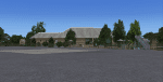
Gmax representation of Skukuza Airport (FASZ), Kruger National Park, Mpumalanga, South Africa with photoreal textures. Skukuza airport is situated inside the Kruger National Park and is served twice daily by commercial flights form Johannesburg and once a day by a commercial flight from Cape Town (operated by Airlink). Located in close proximity to Skukuza main camp and the adjoining Sabi Sand Conservancy, the airport is unique in providing direct access into one of the world's largest protected wildlife areas. The rendition of the airport is as it was in August 2013.
Note: Refer to the Aeroworx Blog, http://aeroworxsa.blogspot.com/ for the latest Vector files witch contains the roads and rivers around FASZ.
| Filename: | FASZ__Skukuza_Airport__South_Africa.zip |
| License: | Freeware |
| Added: | 9th October 2014, 13:19:08 |
| Downloads: | 2,154 |
| Author: | Kobus van Wyk, Aeroworx |
| Size: | 18.81 MB |
| Category: Flight Simulator X - Scenery | |
| South Florida and The Bahamas Water Class |
|
Images related to this file:
File Description:
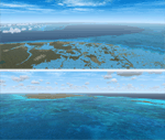
The coverage area begins in the western end of the Florida Keys at The Dry Tortugas, heads north to Tampa, over to Grand Bahama, south to the Cay Sal Bank and eastward to Great Inagua covering all of the Florida Keys and the entire Bahamas Island chain. The scenery also corrects island position errors overlooked by UTX-USA and UTX-TAC in the Dry Tortugas, on the Cay Sal Bank, adding the missing Cays there and also on the Bahama Bank. Lighthouse placement error corrections are also included.
For those pilots with REX Essentials + Overdrive (REX3) a section of the manual is devoted to creating a custom selection of REX3 textures. by Wally-Bob
| Filename: | South_Florida_and_The_Bahamas_Water_Class.zip |
| License: | Freeware, limited distribution |
| Added: | 21st August 2014, 18:50:02 |
| Downloads: | 2,576 |
| Author: | Walter Roberts |
| Size: | 9.25 MB |
| Category: Flight Simulator X - Scenery | |
| Quebec Jean Lesage Int'l Airport CYQB - ver 3.0 |
|
Images related to this file:
File Description:

This high quality scenery is the third edition of the Quebec Jean Lesage Int'l airport (CYQB) for FSX which includes the new terminal extension for regional flights, new buildings, numerous additions and modifications to make this scenery exceptionally accurate. This scenery was designed entirely with Gmax including accurate AFCAD, animations, night lighting and real-world textures. Unique animated panels displaying images of Quebec City area main features are visible inside terminal from gate 28,29,30 and at the rear of terminal taxing from ramp #3. The weather station also has animated anemometer. Whether you fly GA aircrafts or airliners it is certain you will enjoy visiting CYQB and make it your favorite destination.
| Filename: | Quebec_Jean_Lesage_Intl_Airport_CYQB__ver_30.zip |
| License: | Freeware |
| Added: | 3rd June 2012, 19:45:29 |
| Downloads: | 15,274 |
| Author: | Gilles Boily |
| Size: | 33.24 MB |
| Category: Flight Simulator X - Scenery | |
| Archipelago of St-pierre & Miquelon (non-flat airport) |
|
File Description:
"The archipelago of St Pierre (LFVP) and Miquelon (LFVM)".
Theses islands are situated in the south of New Foundland island, beetwin Canada and United States.
All the archipelago is made up of a new local mesh, landclass, photorealists textures in 2m/pixel in St-Pierre island (4 seasons and the night) with specific autogen, the harbour, various buildings, churches, and reference marks
visual.
The airport of St-Pierre (LFVP) is created with a non-flat runway, as it
is in reality, whith a true lenght profil.
A basic mission named "De Miquelon à St Pierre" is placed at "beginner"
level for discover easely the archipelago.
This scenery is only for FsX and is not compatible with Fs 2004 (Fs9)."
| Filename: | Archipelago_of_Stpierre__Miquelon_nonflat_airport.zip |
| License: | Freeware, limited distribution |
| Added: | 4th July 2008, 16:11:23 |
| Downloads: | 3,935 |
| Author: | Marc-henri Guitteny |
| Size: | 17.41 MB |
| Category: Flight Simulator X - Scenery | |
| St. Helena, Ascension, and Tristan da Cunha Islands |
|
Images related to this file:
File Description:
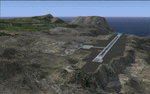
This project was begun to add the new airport (FHSH) to St. Helena Island and eventually was expanded to include a complete remake of Ascension Island (FHAW) and Tristan da Cunha (with an optional airport FHTC) and Gough Island with the actual weather station heliport (FHGH). Tested in both the default FSX/Acceleration and with FTX Global/Vector, accurate coastlines, lakes, road data, and SRTMGL1 (30m) mesh, as well as corrected landclass are provided based on the latest available satellite imagery. Flight plans are provided for the proposed commercial service to St. Helena, and some additional GA and military flights to the island are added as well.
The FSX St. Helena (FHSH) airport was created by aligning master plans for the airport with current satellite data and by studying many of the pictures that have been posted as the airport has taken shape. The official opening of the real airport on May 21, 2016, has been pushed back for more field tests due to challenging crosswinds. The Ascension Island (FHAW) airport was updated after I realized that Ascension could receive commercial service as a result of the new St. Helena airport. The entire airfield is redesigned to allow the volcanic terrain to display properly. The airbase, towns, BBC Atlantic relay station, and numerous satellite dishes, radomes, and wind turbines now appear in their real-world locations. Since I was already in the region, I added the Tristan da Cunha Islands (including Inaccessible, Nightingale and Gough Islands) and the Gough Island weather station maintained by the South African National Antarctic Programme. I also added an optional airport (and flight plans) to Tristan da Cunha (FHTC), which can be easily enabled/disabled. The FHTC airport is placed on the only part of the island that appears to be free of people or farmland, and the area is just long enough to accommodate a pared-down version of the St. Helena airport.
Updates were created or rebuilt in a manner which carefully aligns airport data with current satellite imagery. Scenery was created using Airport Design Editor X v1.67.5684, SBuilderX 3.13, and the FSX Object Placement Tool. Scenery objects were added and modified from stock FSX scenery to resemble as closely as possible the actual airports. The animated flag model is by Dietmar Loleit, the FSX apron lights included are from the set created by Jim Dhaenens, and the animated wind turbines and radomes are from the freeware package by Ray Porter.
| Filename: | St_Helena_Ascension_and_Tristan_da_Cunha_Islands.zip |
| License: | Freeware |
| Added: | 1st May 2016, 11:23:05 |
| Downloads: | 6,072 |
| Author: | Carlyle Sharpe |
| Size: | 10.52 MB |
| Category: Flight Simulator X - Scenery | |
| Tandragee airfield, home of "Kernan Aviation" - Northern Ireland - v1.00 |
|
Images related to this file:
File Description:

Tandragee airfield Northern Ireland, home of "Kernan Aviation" for FSX SP2/Accel/P3D. by Vassilios Dimoulas v1.00 6-10-2014br>
Kernan Aviation (http://www.kernanaviation.co.uk/) operates a fleet of microlight aircraft out of a home strip about two miles north of the town of Tandragee, Northern Ireland. The field is as described in their site, a home strip. There is a 300m long gravel runway with just 3.5m width. The runway intersects a road and has a generally North-South direction (actually 355-175 magnetic). There is an equivalent length grass runway to the east just over the small stream where students practice grass tngs and emergency landings. The field sports a roomy hangar, a clubhouse and a briefing house, as well as outdoor seating and barbecue facilities.
The scenery uses photoreal background and is made to match the FTX Northern Ireland region by ORBX. It will work best with that region activated. Seasonal variations are included for all seasons, including hard winter with snow (January). In order however to cater for those not having this scenery I have provided alternative background bgls for two more options, i.e. ORBX Global textures and GEX textures. The alternative bgls do not have the hard winter option as this is a feature only of FTX NI. The scenery will have also no problem to fit with UTX and Global vector. All buildings were custom made from photos of the original. The scenery has been tested and found to work also in P3D v2.3.
| Filename: | Tandragee_airfield_home_of_Kernan_Aviation__Northe.zip |
| License: | Freeware |
| Added: | 7th October 2014, 12:38:14 |
| Downloads: | 1,094 |
| Author: | Vassilios Dimoulas |
| Size: | 240.38 MB |
| Category: Flight Simulator X - Scenery | |
| Toulouse Blagnac (LFBO) v1 |
|
File Description:
This is an addon scenery for FSX of the Toulouse Blagnac Airport LFBO. It has been made using the excellent freeware tool Airport Design Editor for the layout. I have used Sketchup from Google and Model Converter X to design the buildings of the airport.
You will find all the terminals of LFBO and the control tower, as well as the Airbus facilities of the A380 Lagardere plant North East of LFBO, the A380 delivery center Henry Ziegler North West of LFBO, and some buildings of the Airbus facilities in Blagnac, West of LFBO. All buildings have photo textures, most of them taking with my camera, as I am working in the area. All buildings include night textures. You have two landing pads for helicopters like in reality South East of LFBO.
I used google earth for some items position, but the current view not being up to date, I used my knowledge of the area to correctly position the taxiways, parkings, gates and building position.
I used the FSX generic buildings for the other missing buildings, however they have the size and position which corresponds as far as possible to the position of the real buildings. The surroundings of the airport not being too realistic with Ultimate Terrain X or with FSX, I have modified the landclass of the surroundings to make them look more in accordance with reality. I have changed the parking assignment to make sure that the usual traffic will park on the parkings E, F D AB, V and U.
| Filename: | Toulouse_Blagnac_LFBO_v1.zip |
| License: | Freeware |
| Added: | 21st December 2011, 13:09:29 |
| Downloads: | 23,242 |
| Author: | Jose Mauriz |
| Size: | 34.72 MB |
| Category: Flight Simulator X - Scenery | |
| Hilversum small texture update for NL2000 V4.x |
|
Images related to this file:
File Description:

This zip-file contains replacement textures which improve and bring the big hangar
at Hilversum up to date. This hangar (Benair/Vliegschool Hilversum) has be recently
painted in real-life in fresh white and light blue colours.
The repaint was in principle designed for private use but decided to release it
so more people can enjoy it.
This texture are only compatible with FSX in combination with the NL2000 scenery
version 4.0 NL2000 website: www.nl-2000.com
This addon is in communication with the NL2000 Team approved by NL2000. The NL2000 team
does NOT provide support for this addon. So for support of this addon please contact me.
| Filename: | Hilversum_small_texture_update_for_NL2000_V4x.zip |
| License: | Freeware, limited distribution |
| Added: | 20th April 2014, 13:27:03 |
| Downloads: | 531 |
| Author: | Marcel Ritzema |
| Size: | 4.64 MB |
| Category: Flight Simulator X - Scenery | |
| CZBB - Boundary Bay, BC, Canada (2011) Version 2 |
|
Images related to this file:
File Description:
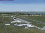
CZBB (2011) portrays the Boundary Bay (British Columbia, Canada) Airport (CZBB) - Canada's fifth-busiest airport by number of operations - and surrounding area as it appeared in mid-2011. Every significant structure on the airfield (50+) is included - all modeled with GMax and painted with hand-drawn textures. CZBB (2011) is compatible with ORBX FTX USA Canada Pacific Northwest, Ultimate Terrain and Vancouver+. A selection of SAMM-generated static aircraft are scattered around the aprons supplemented by a number of AI aircraft that do touch 'n gos from time to time.
Aside from the new custom approach and airfield lighting, generally, this new version is visually identical to its predecessor - even though quite different internally. As well, to the extent possible, it is compatible with Prepar3Dv2.
| Filename: | CZBB__Boundary_Bay_BC_Canada_2011_Version_2.zip |
| License: | Freeware, limited distribution |
| Added: | 20th June 2014, 05:10:24 |
| Downloads: | 3,486 |
| Author: | Don Grovestine |
| Size: | 73.9 MB |
| Category: Flight Simulator X - Scenery | |
| LCPH- Pafos International Airport |
|
File Description:
LCPH- Paphos (Pafos) Airport. Just a basic upgrade of the default scenery. Things added:
Airport vehicles, I've changed the textures of the apron to concrete, I've added an extra taxiway down the back of the airport (just there for visual purposes, there are trees in the way i'm afraid), I've added some planes near the end of RWY 11, I've put in a firestation
Things i would like to do in future versions.
Remove trees at the extra taxiway- to do this i need someone to explain how to "flaten" the trees
Tested on a system upgraded to Acceleration so i'm not sure of results on lesser versions of FSX. I am not responsible for any damage to your system.
| Filename: | LCPH_Pafos_International_Airport.zip |
| License: | Freeware, limited distribution |
| Added: | 19th April 2009, 11:29:42 |
| Downloads: | 2,717 |
| Author: | James Parkes- SD Scenery Design |
| Size: | 3.14 MB |
© 2001-2026 AVSIM Online
All Rights Reserved
Privacy Policy |