
Where Flight Simulation Enthusiasts Gather from Around the World!
AVSIM Library - Search Results

| Category: Flight Simulator X - Scenery | |
| LOWG- Graz Airport - Graz, Austira |

|
File Description:
Graz Airport, known as Flughafen Graz-Thalerhof in AUSTRIA, is a minor international airport in Graz, the second-largest city in Austria. It is located in the south of the alps the airport serves flights to European leisure and some metropolitan destinations. In this version you have new animated people, no flickering, new animated vehicle, new Taxiway-lights, seasonal textures, Hospital UKH-Graz and LKH-Graz, new buildings around the Airport.
This will be my last freeware-version of LOWG.
This version is tested in FSX and P3D, thank you and have fun.
Manfred Marbler.
| Filename: | LOWG_Graz_Airport__Graz_Austira.zip |
| License: | Freeware |
| Added: | 5th March 2016, 12:04:30 |
| Downloads: | 6,301 |
| Author: | manfred marbler |
| Size: | 454.79 MB |
| Category: Flight Simulator X - Scenery | |
| EGXJ - RAF Cottesmore - Rutland, England |
|
File Description:
RAF Cottesmore (ICAO EGXJ) is a former Royal Air Force station in Rutland, England, situated between Cottesmore and Market Overton.
The Stationed opened on 11 March 1938 and was used mainly for training, and the first squadrons were equipped with Vickers Wellesley aircraft, but soon converted to Fairey Battles. Later RAF Bomber Command took over the airfield, again as a training station, flying Handley Page Hampdens. These units remained in residence until a few days before the outbreak of war in 1939 when they were sent to RAF Cranfield to serve as a pool providing replacements for combat losses. Their place at Cottesmore was taken by Nos. 106 and 185 Squadrons, moving in from RAF Thornaby with Hampdens. However, with the outbreak of war, the aircraft and crews were sent to locations in the north and west, as enemy air attacks were expected over the southern half of England. As these never materialised, the Hampdens returned in the spring of 1940 and No. 185 Squadron became the Hampden operational training unit, No. 14 Operational Training Unit RAF.
RAF Cottesmore's Hampdens' first trespass into hostile airspace was a leaflet dropping operation over northern France. In October 1940, 106 Squadron moved to RAF Finningley while No. 14 OTU remained training crews for Bomber Command, its Hampdens and HP.53 Herefords being replaced by Vickers Wellingtons in 1942. Training continued for three years and three months until August 1943 when No. 14 OTU moved to RAF Market Harborough.
In early December 2009, it was announced the station would close due to funding cut-backs, in part to help pay for additional helicopters for British operations in Afghanistan.
In 2010, No. 4 Squadron RAF disbanded, with No. 20 Squadron RAF re-badging as No 4 (Reserve) Squadron.
The station became a satellite to RAF Wittering on 31 March 2011 with a civic parade and flypast to mark the disbandment of No 1 Sqn RAF, 800 NAS, 801 NAS and JFH.
In July 2011 Defence Secretary Liam Fox announced plans for it to be the airfield for one of five of the Army's Multi-Role Brigades. In April 2012 it was renamed Kendrew Barracks after Major General Sir Douglas Kendrew.
Source: Wikipedia
| Filename: | EGXJ__RAF_Cottesmore__Rutland_England.zip |
| License: | Freeware |
| Added: | 19th March 2016, 12:15:07 |
| Downloads: | 344 |
| Author: | Terry Boissel |
| Size: | 1.66 MB |
| Category: Flight Simulator X - Scenery | |
| DL_NFI.zip |
|
File Description:
The Scenery includes a Fotoreal orientation of the "Nordfriesischen Inseln" in the north of Germany (North Sea) including the island Helgoland for the FSX.
The Scenery is based on Google Earth Satellite images.
Islands:
Sylt, Amrum, Föhr, Lageness, Hooge, Pellworm, Nordstrand and Helgoland .
Textures are partially with LOD 14 (2,4 m/pix) . The island Sylt is in LOD 13 (4.7 m/pix) .
Shore lines are included for Sylt (West coast) und Amrum (West coast).
In addition 6 Objects:
- Lighthouse from Hörnum (Sylt)
- Lighthouse from Kampen ( Sylt)
- Lighthouse from Amrum
- A ballon on the beach of Kampen (Sylt).
- Sheeps on the little island auf Hooge ( who can find them ?)
| Filename: | DL_NFIzip.zip |
| License: | Freeware |
| Added: | 4th October 2008, 20:36:37 |
| Downloads: | 7,286 |
| Author: | Dietmar Loleit |
| Size: | 12.65 MB |
| Category: Flight Simulator X - Scenery | |
| KVBG Vandenberg AFB v2.0 |
|
File Description:
Vandenberg Air Force Base is headquarters for the 30th Space Wing. The 30th manages Department of Defense space and missile testing, and placing satellites into polar orbit from the West Coast, using expendable boosters. Vandenberg is located on California's "Central Coast". Vandenberg and central California's coastal residents consider their environment mild. The 150 square mile area midway between San Francisco and Los Angeles is surrounded by the Santa Ynez Mountains, the Pacific shore, and ranches of northern Santa Barbara and San Luis Obispo Counties. This file has been designed to work on both FS2004 and FS-X platforms. Requires RWY 12 library textures (available at www.avsim.com) for full enhancement.
| Filename: | KVBG_Vandenberg_AFB_v20.zip |
| License: | Freeware |
| Added: | 12th November 2006, 22:21:11 |
| Downloads: | 2,201 |
| Author: | Brian C. Selb |
| Size: | 86.07 KB |
| Category: Flight Simulator X - Scenery | |
| White Island Photoreal Scenery (2nd of 4 releases) |
|
File Description:
This is the second of four photoreal scenery releases covering the main offshore islands in the Bay of Plenty, New Zealand.
This scenery was created from a scanned aerial photograph owned by Environment Bay of Plenty (The Bay of Plenty Regional Council). The imagery has been de-sampled for use in Flight Simulator X and utilizes the default terrain mesh. The textures are intended for summer daylight flying only, although due to the sparse nature of White Islands’ vegetation, the Islands appearance remains relatively consistent throughout the year.
It includes Steam, autogen objects (including a library object which vaguely resembles the abandoned Sulphur works) and animated birds.
| Filename: | White_Island_Photoreal_Scenery_2nd_of_4_releases.zip |
| License: | Freeware, limited distribution |
| Added: | 30th April 2007, 23:46:45 |
| Downloads: | 2,930 |
| Author: | Tim Barnes |
| Size: | 4.77 MB |
| Category: Flight Simulator X - Scenery | |
| Ireland EISG Sligo Airport |
|
File Description:
EISG Sligo Airport is a small regional airport located in the North west of Ireland. The scenery includes all custom buildings including new hangers and enterprise centre. Buildings have been created from high resolution photographic images accurately placed using Irish ordinance survey data images. The airport also includes full night textures, static aircraft, people, vehicles, sound effects and animations. This file uses people from my Low Poly 3D aircrew file and objects from my Ireland Static Object library. It can also be used as a standalone scenery file. It was designed for, and is best appreciated with VFR photographic scenery.
Full installation instructions are included in the readme file. Please enjoy.
| Filename: | Ireland_EISG_Sligo_Airport.zip |
| License: | Freeware |
| Added: | 14th October 2011, 18:01:05 |
| Downloads: | 2,615 |
| Author: | George Keogh |
| Size: | 39.83 MB |
| Category: Flight Simulator X - Scenery | |
| Albany International Airport (KALB) Albany, New York |
|
Images related to this file:
File Description:
This airport was made using Airport Design Editor, Google Sketchup, and Instant Scenery 2. Albany International Airport, Is an airport located near Albany, New York. The airport has scheduled airline flights. Almost all of the buildings are custom made with photo textures to make it closer to real life. At the main terminal, I added more gates and put moving jetways. The gates have assigned parking codes. There is a parking lot next to the terminal full of cars. I put the airport access road in between the parking lot and the terminal. At the southwest ramp, I put hangars and some you can taxi inside of. If you choose to start off from the southwest DOCK gate, You will start off inside the Million Air Aviation FBO. I also put static aircraft on the ramp too. To the northwest, I put the New York Police hangar. You can start off inside this hangar by choosing the Northwest DOCK gate. Taxiing into or starting off inside a hangar will not cause a crash unless you touch the sides. To the Northeast, I put the cargo terminal with trucks. At the cargo section, I put three FedEx Cessna Caravans. I also put the control tower and the buildings. Tower views are from the roof of the control tower. To the southeast, I put small hangars and the Air National Guard Section with UH-60 helicopters. I extended runway 1/19 to the correct length of 8,500 feet. I also put red, blue, green, and purple Cessna 172s in different places around the airport. There will be more objects if your scenery complexity is set to normal (such as jetways, aircraft, and vehicles). This was all made based on Google Earth Imagery and Bing Maps. There are no night textures for the buildings. This will be added in a future version. An installer program is included to install the airport for you. There will be more versions of this that include night textures and static business jets. This is for Flight Simulator X only. By Tyler Lawrence.
| Filename: | Albany_International_Airport_KALB_Albany_New_York.zip |
| License: | Freeware |
| Added: | 2nd June 2012, 08:14:12 |
| Downloads: | 4,342 |
| Author: | Tyler Lawrence |
| Size: | 47.69 MB |
| Category: Flight Simulator X - Scenery | |
| Kopaida Airfield, Greece |
|
Images related to this file:
File Description:
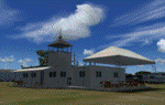
"Kopaida" airfield is a grass private strip, 105km NW of Athens located in the Kopaida drained lake plains between the towns of Aliartos, Kastro and Orchomenos and west of Yliki lake. It is a pure general aviation field and a hub of activity for numerous sport planes, gliders and motor gliders. The field includes a small tower and canteen and several owners of GA aircraft house them in the roomy hangar and also keep a mobile home or RV in the premises. The scenery includes a region and landclass bgl that will force a large area of the Kopaida plains around the airport to display US field textures. This was done because the US fields textures are rectangular and aligned N-E and W-E, in a similar way as the actual fields around the airport. A small photo background is used for the airfield itself. The photo background includes seasonal variations with slight colour variances as well as some autogen trees and shrubs. Custom GA traffic is also included. There is one trike doing circuits and TnGs and a Turbo Porter flying the circuit, simulating a skydiving sortie. The Turbo Porter used is the great freeware one created by Tim (Piglet) Conrad. I have also included a repaint for the F-GHVH, the Porter used by the GFFC, which sports a flashy "Alien" graffiti scheme.
*For FSX SP2 / Acceleration / P3D v1.00*
| Filename: | Kopaida_Airfield_Greece.zip |
| License: | Freeware |
| Added: | 3rd June 2014, 21:23:30 |
| Downloads: | 1,472 |
| Author: | Vassilios Dimoulas |
| Size: | 25.01 MB |
| Category: Flight Simulator X - Scenery | |
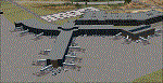
| ZGGG Guangzhou Baiyun Int'l Airport 2017 |
|
File Description:
Guangzhou Baiyun International Airport (ZGGG) is the major airport of Guangzhou, China. Located in Guangzhou's Baiyun District, it opened on August 5, 2004, but has gone through major changes since FSX was created. The default version only has one terminal and two runways and is slightly out of place from the actual location. I placed the airport in its real location based upon the charted latitude and longitude of the airport reference point. Guangzhou Baiyun Int'l Airport now has three runways. The third runway opened in February 2015. The centerpiece is the new Terminal 2, faithfully rendered here as much as possible. The terminal footprint and gates are accurate. The 3D terminal itself is a simple Sketchup project with generic textures (including night textures). The scenery converted and placed using MCX's amazing Convert and Place Wizard. I added the FBO ramp and the FEDEX Cargo Ramp Aprons and added some hangars to both locations, all default FSX buildings, so no additional library downloads are required. The new runway (now called 02R/20L) was added with Airport Design Editor. The old runway 02R/20L was renamed to the current runway 02L/20R and the old runway 02L/20R was renamed to the current runway 01/19. All taxiways are accurately drawn and designated with taxisigns using the latest AIRAC 1712 Jeppesen chart for ZGGG. All six ILS approaches are rendered as well as ADE would let me.
| Filename: | ZGGG_Guangzhou_Baiyun_Intl_Airport_2017.zip |
| License: | Freeware |
| Added: | 26th November 2017, 22:43:37 |
| Downloads: | 1,083 |
| Author: | Randy Tyndall |
| Size: | 490.4 KB |
| Category: Flight Simulator X - Scenery | |
| YMHB - Hobart Airport, v2.1 |
|
Images related to this file:
File Description:
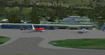
Featuring custom GMAX models, landclass changes, satellite imagery, and AFCAD airport update, Hobart International Airport (YMHB) is the result of several years development. The model itself has been designed with first hand knowledge and is highly accurate to the real airport, with photoreal textures been used. This download includes the nearby Mt. Wellington observatory and signal tower. It is recommended to be flown with FTX landclass installed. A free no restrictions demo of Tasmanian landclass is available from FTX at www.fullterrain.com/freeware.html. v2.1 makes several improvements on the previous version, with upgrades including: updated afcad; enhanced satellite imagery; several new custom models; and a significant improvement to the helicopter area behind the main terminal.
| Filename: | YMHB__Hobart_Airport_v21.zip |
| License: | Freeware, limited distribution |
| Added: | 10th May 2010, 07:30:16 |
| Downloads: | 7,756 |
| Author: | Matthew and Sean Devenish |
| Size: | 16.2 MB |
© 2001-2026 AVSIM Online
All Rights Reserved
Privacy Policy |