
Where Flight Simulation Enthusiasts Gather from Around the World!
AVSIM Library - Search Results

| Category: Flight Simulator X - Scenery | |
| 75 AI Ships and AI Ship Traffic - Mediterranean Sea and Asia |

|
Images related to this file:
File Description:
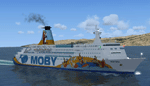
This package contains 75 different AI Ships with FPS friendly textures and models based on real ships including the world largest container ship Maersk Mckinney Moller and a collection of other ships including cruise ships, ferries, oil tankers, bulk carriers, gas tankers, sail ships, research vessels all with numerous repaints. This package also includes a full set of AI shipping routes for the Mediterranean Sea from Gibraltar to Istanbul and Port Said and for Asia from Tokyo to Kuala Lumpur. Ships will visit among other harbors: Hong Kong, Singapore, Kobe, Busan, Dalian, Shanghai, Manila, Xiamen, Macau, Marseille, Valencia, Barcelona, Livorno, Athens, Malta, Nice, and many more. This package is an expansion of my package 63 AI Ships and AI Ship Traffic for South America and Europe and to benefit fully from this you should install first 63 AI Ships and AI Ship Traffic for South America and Europe and the patch Patch for 63 AI ships and AI Ship Traffic. With everything installed you will have 138 ships sailing the FSX Oceans. This package has been developed with contributions from among others Jean-Pierre Fillion, Didier Lagaffe Puentes and Robystar. I would like to thank these three as well as everybody who have encouraged and supported the project or participated in the beta testing.
More routes for these ships can be expected soon: First look out for AI Ship Traffic for North West Europe.
| Filename: | 75_AI_Ships_and_AI_Ship_Traffic__Mediterranean_Sea.zip |
| License: | Freeware |
| Added: | 16th August 2013, 22:36:00 |
| Downloads: | 13,538 |
| Author: | Henrik Nielsen |
| Size: | 32.51 MB |
| Category: Flight Simulator X - AFCAD Files | |
| DAOO - Oran Ahmed Ben Bella International Airport (Es Senia), Algeria |
|
Images related to this file:
File Description:
The main airport of Oran was recently renamed Oran Ahmed Ben Bella International in honor of the nation's founding president. The airport recently underwent EUR 20 million renovations which added the new 07R/25L runway and extended and renamed the existing 07L/25R runway as well as taxiway construction. Renovations were also done to the main parking apron and terminal building. This airport serves as a hub for Air Algeria and Aigle Azur with service to points in Africa, the Middle East and Europe. Several other airlines serve the airport with Air France beginning service from Paris in the Summer of 2013. The city of Oran (population approx. 759,645) is the second largest city in Algeria and an important industrial, educational and cultural center in Alegria.
Features:
*Expanded parking apron
*Parking ramp for cargo (v1.2)
*Taxiways properly desginated (v1.2)
*New runway 07R/25L
*Extension and renaming of runway 07/25 to 07L/25R
*Parking spots for commercial traffic
*Seperate parking areaa for GA traffic
*Misc airport buildings added
*Airport vehicles and objects throughout the airport
*Fuel service vehicles
*Date palms added
*Military area on the north side of the field with a helipad
*Version 1.1 corrects an issue with a misplaced taxi sign as well as a few minor oversights
*Version 1.2 adds correctly labeled taxiway designators (was able to get a hold of recent accurate charts) as well as correct ILS allignment for 25L
| Filename: | DAOO__Oran_Ahmed_Ben_Bella_International_Airport_E.zip |
| License: | Freeware |
| Added: | 13th April 2013, 23:43:00 |
| Downloads: | 1,140 |
| Author: | Jaison Diaz / Endeavour ai |
| Size: | 138.08 KB |
| Category: Flight Simulator X - Scenery | |
| Santa Cruz de la Sierra - Bolivia |
|
File Description:
Scenery Photoreal: Santa Cruz de la Sierra, Bolivia
Santa Cruz de la Sierra: (English: Holy Cross of the Mountain Range), commonly known as Santa Cruz, is the
capital of the Santa Cruz department in eastern Bolivia (17 45', South, 63 14', West)at 416 m above sea level.
The city of Santa Cruz is located not far from the easternmost extent of the Andes Mountains and they are
visible from some parts of the city its Situated too on the Pirai River.
The city of Santa Cruz and its metropolitan area are home to over 70% of the population of the department and
it is one of the fastest-growing cities in the world.
Airports: (NOT included in this package, just Scenery Photoreal of the city)
Viru Viru International Airport (IATA: VVI, ICAO: SLVR) in Santa Cruz de la Sierra, Bolivia is Bolivia's largest
international airport. Viru Viru handles domestic, regional, and international flights from Bolivia to
North America, South America and Europe and is the hub for Bolivia's biggest airline Boliviana de Aviacion (BoA).
The airport is able to handle the largest commercial jets.
El Trompillo Airport (IATA: SRZ, ICAO: SLET) is located in the south part of Santa Cruz, Bolivia, about 2 km
(1.25 miles) away from the central plaza. Airport type:(Public / Military).
Compatible with both FSX and P3D.
| Filename: | Santa_Cruz_de_la_Sierra__Bolivia.zip |
| License: | Freeware |
| Added: | 23rd June 2015, 17:09:33 |
| Downloads: | 1,712 |
| Author: | Marcos A. Rivas Torrez |
| Size: | 69.85 MB |
| Category: Flight Simulator X - Scenery | |
| INS Vikramaditya |
|
Images related to this file:
File Description:

INS Vikramaditya was commisioned into the Soviet Navy as Baku in 1988. It is the third and final remaining Kiev class carrier, the other two being Admiral Kuznetsov and Lioning. Like Lioning, Vikramaditya was purchased from Russia but that is pretty much where the similarity ends. The Chinese quietly bought Varyag under the guise that it would be converted into another floating hotel or casino as had been done several times in the past; then, almost to everyones surprise, they re-built and announced they had an aircraft carrier. India contracted with Russia to complete the refit which began an epic saga of international proportions that encompassed espionage, honey traps and logarithmically expanding budgets. Originally promised for 2008, the latest quotes expect delivery in October/November 2013.
I think the carrier looks very sporty or yacht-like, with the ski-jump bow and the oversized island which has been criticized for being too far into the middle of the deck; it is said to be India's final non-indigenous warship and future flagship to serve for the next 20 to 30 years.
This model is intended for placement with AI Carriers, by Lamont Clark. It has animated radars, working cables, catapults and deck lights. The IFLOS is calibrated, but the catapults will only activate if the airplane deploys a launch bar. The Vikramaditya uses retractable chocks to allow aircraft to develop full thrust, but I could not find a way to lock an aircraft to represent the STOBAR configuration without using catapults. I did not define the elevators because they do not operate and are in the middle of the deck. There are two ships included for escort, the INS Talwar and a Russian Fregat II class ASW destroyer. They have hard decks and night lighting, animated radars, funnel smoke, etc.
| Filename: | INS_Vikramaditya.zip |
| License: | Freeware, limited distribution |
| Added: | 23rd August 2013, 21:43:41 |
| Downloads: | 1,002 |
| Author: | Rick Keller |
| Size: | 18.58 MB |
| Category: Flight Simulator X - Scenery | |
| RAF Bircham Newton - Norfolk, England |
|
File Description:
RAF Bircham Newton is a former Royal Air Force station located 2.1 miles (3.4 km) south east of Docking, Norfolk
and 13.4 miles (21.6 km) north east of King's Lynn, Norfolk, England.
The site was first used during the First World War and received the largest British bomber of the time, the Handley Page V/1500. They would have carried out bombing missions against Berlin but the Armistice was arranged before any missions were actually flown.
The airfield was equipped with one aircraft repair shed and three double bay general service sheds, although these had been demolished by 1937. It had two Belfast hangars, three C Type hangars, three Bellman hangars and ten Blister hangars. It operated through the Second World War as part of No. 16 Group RAF as part of Coastal Command.
No. 206 Squadron RAF was one of the squadrons being based there, on maritime patrol duties. Two satellite airfields, RAF Docking and RAF Langham were opened to accommodate units. In 1965 the airfield was used for evaluation trials of the Hawker Siddeley Kestrel V/STOL aircraft.
After closure as an operational airfield in 1966, the airfield became the home of the Construction Industry Training Board. The runways have gone, but the majority of buildings on the site, including some hangars and the control tower, remain in use by the CITB.The control tower was demolished in 2010 due to its poor condition. Constructionarium is also based within the estate, providing a week's practical learning opportunity for undergraduates
| Filename: | RAF_Bircham_Newton__Norfolk_England.zip |
| License: | Freeware |
| Added: | 25th December 2015, 18:15:50 |
| Downloads: | 360 |
| Author: | Terry Boissel |
| Size: | 1.6 MB |
| Category: Flight Simulator X - Scenery | |
| RNAS Anthorn (HMS Nuthatch) - Cumbria, UK |
|
File Description:
This scenery is a representation of RNAS Anthorn (HMS Nuthatch) prior to runway and taxiway upgrades completed in 1948. It is not 100% accurate and no claim is being made that it is.
The scenery was made using ADE and is intended for use in FSX along with Horizon GenX VFR scenery but should work ok in Basic FSX.
Some History: Anthorn air field (also known as RAF Anthorn, RNAS Anthorn and HMS Nuthatch) was an airfield approximately 430 KM north-northwest of London
The airfield was built in february 1918 as a Fleet Air Arm (FAA) airfield. It was abandoned after World War I ended, however. The RAF reinstated the airfield at the beginning of World War II as an emergency landing ground for nearby RAF Silloth.
The site was taken over by the Royal Navy in December 1942, and renamed the site RNAS Anthorn. It was commissioned in September 1944 as 'HMS Nuthatch'.
The airfield served as No. ARDU (Aircraft Receipt and Dispatch Unit), a unit that accepts aircraft from their manufacturers and prepares them for operational use.
The last official flight took off from the airfield in November 1957. It was then put on Care and Maintenance, before it closed down in March 1958.
In 1961 the site was chosen to become a NATO VLF transmitting site for communicating with submarines. Construction of the site, by Continental Electronics of Dallas, U.S.A., began in 1962.
The station was accepted on behalf of the MoD in November 1964.
| Filename: | RNAS_Anthorn_HMS_Nuthatch__Cumbria_UK.zip |
| License: | Freeware |
| Added: | 1st March 2015, 23:11:58 |
| Downloads: | 435 |
| Author: | Mark Byers |
| Size: | 21.34 MB |
| Category: Flight Simulator X - Aircraft Repaints, Textures and Modifications | |
| B-24 USAAF 376th BG "Lady be Good" |
|
File Description:
Following an April 4, 1943 bombing raid on Naples, Italy, conducted by the 376th Bomb Group, the Lady Be Good of the 514th Bomb Squadron failed to return to base. After attempts to locate the plane, its nine crewmen were classified as MIA, and presumed dead, believed to have perished after crashing in the Mediterranean.
Almost 16 years later on Nov. 9, 1958, several British geologists were flying over the desolate, sun-baked Libyan Desert. At approximately 400 miles south of Soluch, they spotted an aircraft on the sand. A ground party that reached the site in March 1959 discovered the plane to be a B-24D. The "Lady Be Good" had been found.
Evidence at the site indicated that the crew had become lost in the dark on return from Naples and had flown over their base and southward into the desert. As their fuel supply became depleted, the nine men aboard had bailed out but had disappeared while attempting to walk northward to civilization.
Intensive searches were made for clues as to the fate of the crew, and in 1960 the remains of eight were found, one near the plane and the other seven far to the north. Five had trekked 78 miles across the tortuous sand before perishing and one had gone an amazing 109 miles. In addition, they had lived eight days rather than only two expected of men in this area with little or no water. The body of the ninth man was never found.
Repaint for the Alphasim B-24 by Jan Kees Blom.
| Filename: | B24_USAAF_376th_BG_Lady_be_Good.zip |
| License: | Freeware |
| Added: | 11th October 2008, 13:11:09 |
| Downloads: | 386 |
| Author: | Jan Kees Blom |
| Size: | 7.61 MB |
| Category: Flight Simulator X - Aircraft Repaints, Textures and Modifications | |
| B-24 USAAF 489th BG "Sharon D" |
|
File Description:
This Ford-built B-24H was assigned to Lt Col Leon Vance, deputy commander of the 489th BG. It was Vance who had brought the aircraft from the US to Halesworth. The bomber was named after its pilot’s infant daughter Sharon, who had been born in 1942. Lt Col Vance was flying a different aircraft on the 5 June 1944 mission against a German coastal defence complex near Wimereaux, France-a mission in which the latter aircraft was lost, and for which Vance was awarded the Medal of Honor. He was the only B-24 crew member in the Eighth Air Force accorded this distinction whilst flying a mission from the UK. Vance was heading home to recover from combat wounds when he went down on a C-54 Skymaster carrying wounded and crippled veterans over the North Atlantic on 26 July 1944. In October 1946, at the age of four, Sharon Vance travelled via US Army Air Forces transport to Enid, Oklahoma (now home of Vance Air Force Base), for a ceremony in which Maj Gen James P Hodges gave her the Medal of Honor awarded to her father. Today, daughter Sharon Kiernan of San Diego, California, is an Air Force wife, and she helps to keep alive the memory of her father, and of the bomber named after her. The Sharon D retained its nickname throughout the war, and was eventually transferred to the 445th BG. It survived the conflict, and was eventually broken up for scrap.
Repaint by Jan Kees Blom for the AlphaSim 2008 Consolidated B-24 Liberator
| Filename: | B24_USAAF_489th_BG_Sharon_D.zip |
| License: | Freeware |
| Added: | 31st October 2008, 18:18:46 |
| Downloads: | 478 |
| Author: | Jan Kees Blom |
| Size: | 8.27 MB |
| Category: Flight Simulator X - Aircraft Repaints, Textures and Modifications | |
| De Havilland Canada DHC-6 Twin Otter CIRPAS #236 |
|
Images related to this file:
File Description:

This folder contains a repaint for the Aerosoft Twin Otter Extended, in the colors of 762256 (c/n 496). Formerly N83NX, this aircraft is registered with the US Navy, but flying for the Center for Interdiciplinary Remotely-Piloted Aircraft Studies (CIRPAS), a research center at the Naval Postgraduate School in Monterey, California. The CIRPAS Twin Otter is an instrumented twin-engine turboprop aircraft. It supports individual scientists as well as teams of scientists from various Universities and Laboratories who are interested in lower-tropospheric phenomena and air/sea interaction. Payload may be selected from a large suite of state of the art meteorological, aerosol, and cloud particle sensors, while additional equipment collaborating scientists may wish to include can be integrated as well. Twin Otter mission have been sponsored by ONR, NSF, DOE, NOAA, NASA, CARB, and NRL.
Instruments may be installed in racks inside the cabin where a well characterized community inlet delivers ambient air samples, or in pods either suspended by wing-mounted pylons or mounted on a hard point on the cabin roof. Optical ports and windows are on the airplane’s belly and in the cabin roof.
CIRPAS staff calibrates and maintains the facility payload and provides fully reduced, synchronized, and coherent data sets to the collaborating scientists.
The Twin Otter is based at the CIRPAS Marina Facility, but has been deployed to various locations in North, South, and Central America and Asia. Repaint by Jan Kees Blom, based on the paintkit by Aerosoft.
| Filename: | De_Havilland_Canada_DHC6_Twin_Otter_CIRPAS_236.zip |
| License: | Freeware |
| Added: | 14th July 2018, 16:51:20 |
| Downloads: | 218 |
| Author: | Jan Kees Blom |
| Size: | 16.23 MB |
| Category: Flight Simulator X - Scenery | |
| Amundsen-Scott Station |
|
File Description:
The Amundsen-Scott South Pole Station is the American scientific research station on the high plateau of Antarctica. This station is located at the southernmost place on the Earth, the Geographic South Pole, at an elevation of 2,835 meters (9301 feet) above sea level.
Since the Amundsen-Scott Station is located at the South Pole, it is at the only place on the land surface of the Earth where the sun is continuously up for six months and then continuously down for six months. (The only other such place is at the North Pole, on the sea ice in the middle of the Arctic Ocean.) Thus, during each year, this station experiences one extremely long "day" and one extremely long "night". During the six-month "day", the angle of elevation of the Sun above the horizon varies continuously. The sun rises on the September equinox, reaches its maximum angle above the horizon on the summer solstice in the Southern Hemisphere, around 20 December, and sets on the March equinox.
During the six-month "night", it gets extremely cold at the South Pole, with air temperatures sometimes dropping below -73�°C (-100�°F). This is also the time of the year when blizzards, sometimes with gale-force winds, strike the Amundsen-Scott Station. The continuous period of darkness and dry atmosphere make the station an excellent place from which to make astronomical observations.
This file has the apron and characteristics of the airport the coordenates are placed as far south as FS allow it.
| Filename: | AmundsenScott_Station.zip |
| License: | Freeware |
| Added: | 17th October 2011, 22:01:33 |
| Downloads: | 1,294 |
| Author: | Anwar Gonzalez |
| Size: | 5.92 KB |
© 2001-2026 AVSIM Online
All Rights Reserved
Privacy Policy |