
Where Flight Simulation Enthusiasts Gather from Around the World!
AVSIM Library - Search Results

| Category: Flight Simulator X - Aircraft Repaints, Textures and Modifications | |
| Fiji Airways Boeing 777-200ER (GE) (DQ-FJT) |

|
Images related to this file:
File Description:

This is a repaint of a Boeing 777-200ER, registration code DQ-FJT, operated by Fiji Airways, the flag carrier airline of Fiji. It operates international and domestic services to 10 countries and 15 cities around the Pacific, including Australia and New Zealand, North America and Hong Kong. While Fiji Airways currently does not operate any Boeing 777-200ERs, they did lease and operate one in 2012.
This repaint has plenty of clear markings so if you enjoy exterior detail, then you will love this repaint. You can see (and read): Door opening instructions; Static port directions; Air vent warnings; Engine hazard area; No Step warnings; RAT caution; APU intake warning; Stabilizer compartment access; Ground power supply; Forward and aft access door instructions; Pitot, ADA probe, Ice detector and TAT probe markings; Visible rivets; Enhanced window frames; Authentic Fiji logo; Bold, colorful Fiji livery and authentic flags; Lovely Fiji flight attendant; No frame rate hit.
To use this repaint, the Captain Sim B777-200 exterior model is required.
| Filename: | Fiji_Airways__Boeing_777200ER_GE_DQFJT.zip |
| License: | Freeware |
| Added: | 6th March 2014, 00:28:59 |
| Downloads: | 767 |
| Author: | Garrett Rowley, Captain Sim |
| Size: | 28.66 MB |
| Category: Flight Simulator X - Scenery | |
| RAF Shepherds Grove - Suffolk, England |
|
File Description:
RAF Shepherds Grove is a former Royal Air Force station located 9.9 miles (15.9 km) north-east of Bury St Edmunds, Suffolk, England.
The Station was originally built for the United States Army Air Forces (USAAF) Eighth Air Force during the Second World War. However the facility was not used by the USAAF and was opened by No. 3 Group RAF on 3 April 1944. The name came from a small copse nearby and the airfield is close to Walsham le Willows in Suffolk.
It was occupied by No. 196 Squadron RAF in January 1945 as a base for Operation Varsity, supporting the Rhine crossing.
Various American units occupied the station after WW2 but ended their use of the unit in December 1958.
On 22 July 1956, No. 82 Squadron RAF was activated at Shepherds Grove as a Thor missile unit. Thor launching sites were built on the main airfield and became operational in 1959.
The base was closed in 1966. Third party files are required - see the readme.txt for details.
| Filename: | RAF_Shepherds_Grove__Suffolk_England.zip |
| License: | Freeware |
| Added: | 4th December 2015, 09:34:13 |
| Downloads: | 159 |
| Author: | Terry Boissel |
| Size: | 13.26 KB |
| Category: Flight Simulator X - AFCAD Files | |
| LYUZ - Ponikve airport - Uzice, Serbia |
|
File Description:
Uzice Ponikve Airport (Serbian: Aerodrom Uzice Ponikve) (IATA: UZC, ICAO: LYUZ); also known as Lepa Glava (literally: Beautiful Head) is an airport in the western part of Serbia. The airport is located at Ponikve (literally: Sinkholes) plateau: 8 km (5 mi) southwest from the Jelova Gora, 11 km (7 mi) east from the Mount Tara, 12 km (7.5 mi) northwest from the city of Uzice, 13 km (8 mi) southeast from the town of Bajina Basta, 19 km (12 mi) northeast from the popular tourist center with unique attractions of the Mokra Gora, 20 km (12.5 mi) north from the Mount Zlatibor, 20 km (12.5 mi) southwest from the town of Kosjeric, 27 km (17 mi) northwest from the town of Pozega, 32 km (20 mi) southwest from the Mountain resort Divcibare, 35 km (22 mi) northeast from the town of Visegrad in Republic of Srpska (BiH), 50 km (31 mi) northwest from the Mount Zlatar. The airport is partially reconstructed in order to become an international airport. Charts included
| Filename: | LYUZ__Ponikve_airport__Uzice_Serbia.zip |
| License: | Freeware |
| Added: | 18th August 2016, 03:56:56 |
| Downloads: | 245 |
| Author: | Danilo Jankovic |
| Size: | 3.56 MB |
| Category: Flight Simulator X - Flight Plans | |
| Flying For Furs.....A Danger in the Mountain Gorges, Ravines, and Canyons of The Canadian West... |
|
File Description:
Joshua Buckhorn is getting ready for his trip into the Canadian Wester Fur Route. As a trader of furs and FBO owner things up here in North Washington
are hard in this year of 1949. Just 5 years ago he was flying a huge B-17 over Germany. Now a new life has brought him into the dangers on Bush Flying.
As always before these flights, new oil and spark plugs must be placed in the plane, tyres must be just right and the fuel tanks got to be full to the top.
It is 5:45 AM and a big breakfast is a must before the flight, eggs, grits, potatoes, ham, bacon and NO beans since the gas they produce will disrupt the fligh. And don´t forget the "P" Bottle.----I hope you know how to balance a plane with all those furs and hides you will acquire in this trip full of danger in approaches and take offs from, indeed, very dangerous fields. ( Bonus you get 4 new airports for future flights if the business pays off)..:)
| Filename: | Flying_For_FursA_Danger_in_the_Mountain_Gorges_Rav.zip |
| License: | Freeware, limited distribution |
| Added: | 22nd August 2008, 23:09:46 |
| Downloads: | 1,078 |
| Author: | Gera Godoy Canova |
| Size: | 365.52 KB |
| Category: Flight Simulator X - Scenery | |
| FSX: Enhanced Major Metro Autogen (requires FSX Enhanced Autogen World ) |
|
File Description:
This is the second and final part of our enhanced autogen release. This package repairs and upgrades 48 major city autogen building textures world-wide and RESTORES the light maps Aces missed in which large numbers of buildings (Paris, Berlin, London, etc) have been dark since the release of FSX. It includes North America, South America, Asia, Eurasia, Middle East, Europe, Africa and Australia. You MUST install PART ONE (fsx_enhanced_autogen.zip) before using this package. There are links included with the instructiions of this package to PART 1 should you need them along with instructions for FTX users. The included textures will add all the default missing light maps, blend perfectly with GEX Enhanced USA/Canada and are a great match for our upcoming GEX Europe release. Please note these are only textures for major metro auto-generated buildings and are not the city skyscrapers and landmarks. There is absolutely no performance loss -or- performance gain when using these textures which are ONLY for FSX and can not be used in FS9. Happy Holidays from Team GEX to the entire sim community!
| Filename: | FSX_Enhanced_Major_Metro_Autogen_requires_FSX_Enha.zip |
| License: | Freeware, limited distribution |
| Added: | 27th December 2008, 02:28:47 |
| Downloads: | 14,644 |
| Author: | Nick Needham and Anthony Vos of Ground Environment X |
| Size: | 14.21 MB |
| Category: Flight Simulator X - Aircraft Repaints, Textures and Modifications | |
| Cessna C206H Stationair v2.1 |
|
File Description:
This is a North American Registry (N206RX) re-paint of the FREEWARE Cessna C206H Stationair VERSION 2.1 (Complete Aircraft) by Blue Sky Simulations, Roger Bonne & GUIDEE Francois-Denis. VERSION 2.1 has been reworked after reports of a few errors in the files. ALL ERRORS HAVE BEEN CORRECTED! This model has been throughly flight tested and flys like a dream! All textures are rendered in DXT-3 format for crisp texturing without sacrificing frame rates. Originally modeled for FS2004, this rendition of the sturdy aircraft has been modified to work within the FS-X platform. Includes customized panel and sound package by Peter Spanakos. Both an analog and Garmin G1000 glass panel versions have been included. ***** This file superceeds my earlier C206H Stationair (file name: c206_n206rx_v2.zip) and is recommended as a stand-alone download or a replacement for existing users of my previous version. The only difference is a self-installation program and corrected sound ***** This aircraft has no VC (Virtual Cockpit) and is meant to be flown with the 2-D panel only! This file is for FS-X only!
| Filename: | Cessna_C206H_Stationair_v21.zip |
| License: | Freeware |
| Added: | 24th December 2006, 02:34:24 |
| Downloads: | 3,263 |
| Author: | Blue Sky Simulations, Roger Bonne, GUIDEE Francois-Denis, Peter Spanakos & Brian C. Selb |
| Size: | 13.66 MB |
| Category: Flight Simulator X - Scenery | |
| YBIU Ballidu, Western Australia |
|
File Description:
YBIU Ballidu is a town located in the Wheatbelt region of Western Australia, about 217 kilometres (135 mi) north of Perth. The townsite was gazetted in 1914, with street names of the original settlers. A primary school opened in the town on 4 September 1922, moving into permanent premises in 1924. Ballidu has a population of less than 100 people and consists of Ballidu Primary School, the local Art Gallery, a hall, a few shops for groceries and essentials and several farming supply stores. As Ballidu is a farming region, over the years (as the size of the surrounding farms has increased), the town has become smaller and smaller.
This airfield is run by Dunn Aviation and mainly home for their Air Tractor and Dromadaire fleet. (I have created a low poly version beacuse its my first aircraft model). It has a windsock and hangar but little else.
REQUIRES blencowe_librarykit_309494.zip (Available HERE)
| Filename: | YBIU_Ballidu_Western_Australia.zip |
| License: | Freeware |
| Added: | 25th February 2013, 08:24:07 |
| Downloads: | 468 |
| Author: | Alan Blencowe |
| Size: | 2.76 MB |
| Category: Flight Simulator X - Scenery | |
| YGNW Gnowangerup Shire airstrip and town, Western Australia |
|
File Description:
YGNW Gnowangerup Shire Airstrip. The Shire of Gnowangerup is a Local Government Area in the Great Southern region of Western Australia, about 120 kilometres north of Albany and about 370 kilometres southeast of the capital, Perth. The Shire covers an area of 4,268 square kilometres, and its seat of government is the town of Gnowangerup. Gnowangerup was initially gazetted as a Road Board in 1912, taking in eastern sections of Broomehill and Tambellup. On 1 July 1961, it became a Shire Council following changes to the Local Government Act. The area of gnowangerup is mainly wheat sheep on sandplain country. In the 1960's it was reported to have good rainfall but when the clearing started, the rainfall changed. Farmers who managed large properties were able to survive because of the economies of scale. At regular intervals, farmers in this area now have to cart water for their stock. REQUIRES Blencowe_LibraryKit.zip
REQUIRES blencowe_librarykit_309494.zip (Available HERE)
| Filename: | YGNW_Gnowangerup_Shire_airstrip_and_town_Western_A.zip |
| License: | Freeware |
| Added: | 28th February 2013, 02:44:27 |
| Downloads: | 261 |
| Author: | Alan Blencowe |
| Size: | 5.39 MB |
| Category: Flight Simulator X - Scenery | |
| Essweiler Gliderfield, Germany Ver. 1.0 |
|
Images related to this file:
File Description:
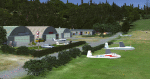
Essweiler is actually a classic glider field, but also engine aircrafts up to 2t are approved.
The field is situated in the region Rheinland-Pfalz/Germany at a hillside eastly of the village Essweiler, approximately 7,5 nautical miles north of the well known US-Airbase Ramstein.
The environment of the airfield is adapted by land classes. Surrounding villages and major roads are initially implemented.
As well the field is covered by a photo background, which includes four different images , each for one of the four seasons: spring, summer, autumn and winter. The buildings in this scenery should match quite good the originals. But also a lot of objects from three very popular freeware libraries are used.
If these libraries are not installed, many objects are not visible!
The following libraries are used:
1. FS-Piloten_Objektlibrary:
http://www.fs-piloten.de/thread.php?threadid=1063
2. FSX_FlightPortLib
http://www.flightport.de/libraries/flightport-library/
3: 3d People Library
http://library.avsim.net/download.php?DLID=192454
| Filename: | Essweiler_Gliderfield_Germany_Ver_10.zip |
| License: | Freeware |
| Added: | 29th November 2016, 19:15:50 |
| Downloads: | 605 |
| Author: | Wolfgang Allers |
| Size: | 168.18 MB |
| Category: Flight Simulator X - Scenery | |
| LEMG-Xv4 |
|
Images related to this file:
File Description:
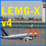
Shortly after the release of LEMG-Xv3 I've noticed it contained too many errors..A complete redo of the RWY 13+31 entrances. It's a little more complicated then FSX made it look like. Yet after finishing v4 I discovered a picture of the building of a second runway. I've tried to include this in my scenery. As in the pictures,it's under construction. This is the 2011situation. Includes D gates [T3 terminal] Jetways at the "D" gates now working. Removed buildings in the area, near the north side of the airport to make room for the new Runway. Adjusted Apron A1 for small aircraft. Added several parking spaces [A2 an A1 platform] Added some static planes on request. After some trial and error actions I was finally able to make some transitions plus missed approaches. You'll now have a proper RWY 13 - MAR transition [ILS13 in the GPS] A GDA Transition to [BLN2B / VIBAS1K] plus VJF1B STAR] Freeware scenery for FSX, just for fun.Made with ADE 1.47.07 Happy Landings!
| Filename: | LEMGXv4.zip |
| License: | Freeware, limited distribution |
| Added: | 30th April 2011, 00:16:20 |
| Downloads: | 2,324 |
| Author: | Joost Visser |
| Size: | 13.35 MB |
© 2001-2026 AVSIM Online
All Rights Reserved
Privacy Policy |