
Where Flight Simulation Enthusiasts Gather from Around the World!
AVSIM Library - Search Results

| Category: Flight Simulator X - Scenery | |
| 6I2 - Lebanon-Springfield Airport - Kentucky, USA [FreeMeshX - USA-optimized] |

|
Images related to this file:
File Description:
Lebanon-Springfield Airport (FAA LID: 6I2), a public use airport in Washington County, Kentucky (KY), USA. It is located three nautical miles (6 km) south of Springfield in Washington County) and north of Lebanon (in Marion County). The airport is owned by Marion and Washington Counties. The scenery contains seasonal ground textures for winter, spring, summer, autumn and night; autogen and default scenery objects of FSX plus a modified AFCAD file. Tested with FSX: SE on Windows 10. Version 1.1 contains fixes for the terrain aswell as corrected scenery objects.
** Do not use this version with the default mesh; use 6I2_NO_FMX.zip instead **
By Peregrine Simulations
| Filename: | 6I2__LebanonSpringfield_Airport__Kentucky_USA_Free.zip |
| License: | Freeware, limited distribution |
| Added: | 21st February 2018, 23:36:13 |
| Downloads: | 415 |
| Author: | Peregrine Simulations |
| Size: | 104.1 MB |
| Category: Flight Simulator X - Scenery | |
| 6I2 - Lebanon-Springfield Airport - Kentucky, USA |
|
Images related to this file:
File Description:
Lebanon-Springfield Airport (FAA LID: 6I2), a public use airport in Washington County, Kentucky (KY), USA. It is located three nautical miles (6 km) south of Springfield in Washington County) and north of Lebanon (in Marion County). The airport is owned by Marion and Washington Counties. The scenery contains seasonal ground textures for winter, spring, summer, autumn and night; autogen and default scenery objects of FSX plus a modified AFCAD file. Tested with FSX: SE on Windows 10. Version 1.1 contains fixes for the terrain aswell as corrected scenery objects.
** Do not use this version with FreeMesh X - USA; use 6I2_FMX.zip instead **
By Peregrine Simulations
| Filename: | 6I2__LebanonSpringfield_Airport__Kentucky_USA.zip |
| License: | Freeware, limited distribution |
| Added: | 21st February 2018, 23:36:38 |
| Downloads: | 250 |
| Author: | Peregrine Simulations |
| Size: | 104.1 MB |
| Category: Flight Simulator X - Aircraft Repaints, Textures and Modifications | |
| Jetairfly / Sun Country Boeing 737-8BK (OO-JAA) |
|
Images related to this file:
File Description:
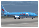
Jetairfly & Sun Country Hybrid repaints for the iFly Jets: The 737NG (B737-800 model). Jetairfly is part of the TUI group and operates both scheduled and charter flights to more than 70 destinations in the Mediterranean, Red Sea, Canary Islands, North Africa and the Caribbean. Now registered OO-JAA, ex-Sun Country N811SY (c/n 29660) is still leased to Sun Country during the winter months where it flies around in a hybrid paint scheme. Fully compatible with SP1. Configuration file containing the customer options of the real OO-JAA included together with custom bump maps. Note: Textures only, iFlySimSoft B737 NG add-on required.
| Filename: | Jetairfly__Sun_Country_Boeing_7378BK_OOJAA.zip |
| License: | Freeware, limited distribution |
| Added: | 27th August 2011, 19:58:11 |
| Downloads: | 646 |
| Author: | Sylvain Coolsaet, iFlySimSoft |
| Size: | 18.55 MB |
| Category: Flight Simulator X - Aircraft Repaints, Textures and Modifications | |
| Icelandair, Boeing 757-208 (TF-FIO) |
|
Images related to this file:
File Description:
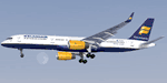
Icelandair is the flag carrier airline of Iceland, based on the grounds of Reykjavik Airport in Reykjavik. It is part of the Icelandair Group and operates services to 32 cities in 14 countries on both sides of the Atlantic. Its main base is Keflavik International Airport. Icelandair's business strategy is based on the geographical position of Iceland on the flight route between northern Europe and North America. By combining its aircraft, passengers visiting Iceland, passengers departing from Iceland and passengers travelling across the Atlantic via Iceland, Icelandair has been able to expand its network steadily. Remember these are textures only, you will need the original Captain Sim 757.
| Filename: | Icelandair_Boeing_757208_TFFIO.zip |
| License: | Freeware |
| Added: | 10th September 2011, 18:21:36 |
| Downloads: | 3,384 |
| Author: | Marco Fischbach |
| Size: | 25.19 MB |
| Category: Flight Simulator X - Missions | |
| HelicopterLighthouseMissionsVol89.zip |
|
File Description:
Six lighthouse tours: Altamira, Grays Harbor, PEI North Cape, Ritidian Point, St.Georges, and Vormsi Saxby.These missions were programmed in Windows 10 (64bit)for FSX Acceleration and will also work in FSX Steam, P3DV3,V4,V5,and V6. However, several of these tours have specific requirements of Orbx scenery which is detailed in the .txt instructions.Photos of all the lites are included in each mission set. Once again, be sure to read the instructions in the .txt files. These missions have been thoroughly tested and should work as described. Due to large topographic differences in P3DV5 and V6, there will be peculiarities, but the missions should still work.
| Filename: | HelicopterLighthouseMissionsVol89zip.zip |
| License: | Freeware |
| Added: | 17th April 2026, 20:38:38 |
| Downloads: | 8 |
| Author: | Helomissionman |
| Size: | 40.5 MB |
| Category: Flight Simulator X - Aircraft Repaints, Textures and Modifications | |
| Cessna C172P (SX-AEW) |
|
Images related to this file:
File Description:

This is a representation of SX-AEW, of the Dekeleia Aeroclub based in Tatoi LGTT, north of Athens. It is used both for training and for flights by all club members holding a PPL. It is also available for pleasure flights and initiation flights for non members. The real one also has extended fuel tank capacity for 6 hours endurance.
The actual plane is an older "P" model with carburetor equipped engine so there are several model differences from the "R" represented by A2A including antennae, and very different cockpit with no headrests and different door interior and instrument panel. The tinted cabin glass has been reproduced in the repaint.
| Filename: | Cessna_C172P_SXAEW.zip |
| License: | Freeware |
| Added: | 18th September 2013, 00:16:55 |
| Downloads: | 342 |
| Author: | Vassilios Dimoulas |
| Size: | 21.71 MB |
| Category: Flight Simulator X - Scenery | |
| RAF Fulbeck - Newark-on-Trent - Nottinghamshire, England |
|
File Description:
RAF Fulbeck is a former Royal Air Force station located 6.3 miles (10.1 km) east of Newark-on-Trent, Nottinghamshire and 10.9 miles (17.5 km) west of Sleaford, Lincolnshire, England.
The airfield is located about 106 miles (171 km) north-northwest of London and was opened in 1940 when it was used by both the Royal Air Force and United States Army Air Forces. During the war it was used primarily as troop carrier airfield for airborne units. It was closed in 1948 and was no longer used by the military and is now privately owned. You will require addon sceneries - see the included readme file for details.
| Filename: | RAF_Fulbeck__NewarkonTrent__Nottinghamshire_Englan.zip |
| License: | Freeware |
| Added: | 13th October 2015, 13:51:01 |
| Downloads: | 307 |
| Author: | Terry Boissel |
| Size: | 71.02 KB |
| Category: Flight Simulator X - Scenery | |
| X3SY - RAF Saltby - Leicestershire, England |
|
File Description:
RAF Saltby (ICAO X3SY)was a World War II airfield in Leicestershire, England. The airfield is located approximately 8 miles (13 km) northeast of Melton Mowbray; about 90 miles (140 km) north-northwestof London.
It was opened in 1942, and was used by both the Royal Air Force and United States Army Air Forces. During the war it was used primarily as a transport airfield. Like many airfields of the time it closed after the war in 1945 but kept in reserve until 1955.
Today the remains of the airfield are located on private property and, now known as Saltby Airfield, is used primarily for gliding.
Source: Wikipedia
| Filename: | X3SY__RAF_Saltby__Leicestershire_England.zip |
| License: | Freeware |
| Added: | 27th April 2016, 15:39:01 |
| Downloads: | 130 |
| Author: | Terry Boissel |
| Size: | 1.36 MB |
| Category: Flight Simulator X - Scenery | |
| RAF Wendling - Norfolk, England |
|
File Description:
RAF Wendling is a former Royal Air Force station located 4 miles (6.4 km) north west of East Dereham, Norfolk, England. Opened in 1942, it was used by both the Royal Air Force (RAF) and United States Army Air Forces (USAAF). During the war it was used primarily as a bomber airfield, being the home of the United States Army Air Forces Eighth Air Force 392nd Bombardment Group. After the war, it was used by the RAF as a standby airfield before being finally closed in 1961 and returned to agriculture. With the end of military control the airfield has become a turkey farm.
| Filename: | RAF_Wendling___Norfolk_England.zip |
| License: | Freeware |
| Added: | 16th February 2016, 17:37:49 |
| Downloads: | 195 |
| Author: | Terry Boissel |
| Size: | 197.67 KB |
| Category: Flight Simulator X - Scenery | |
| ValparaÃso Provincia, Litoral 2016. Chile. For FSX |
|
Images related to this file:
File Description:
Scenery of ValparaÃso Province from North (Quintero) to South (Laguna Verde valley). About 2.000 km2 intervention that brings up to fsx the current urban density, neighborhoods, forests and the most important iconic 3d objects you can recognize from a real VFR flight. This project uses FTX Vector as it main complement (only for the shapes of the coast). Also uses satellite background DAY/NIGHT, SPRING/ FALL / WINTER Photoscenery for Ritoque, Aconcagua, Concon, Embalse Los Aromos, Salinas, Borde Costero de Viña del Mar, Tranque La Luz, Peñuelas. Recomended to use (as an option) with my airport projects. SCVM, SCER, SCRD, SCSN, SCCV, SCIR, SCEL.
| Filename: | Valparaso_Provincia_Litoral_2016_Chile_For_FSX.zip |
| License: | Freeware |
| Added: | 4th November 2016, 04:59:42 |
| Downloads: | 1,097 |
| Author: | Orlando Veas |
| Size: | 180.36 MB |


© 2001-2026 AVSIM Online
All Rights Reserved
Privacy Policy |