
Where Flight Simulation Enthusiasts Gather from Around the World!
AVSIM Library - Search Results

| Category: Flight Simulator X - Scenery | |
| The French Polynesia Tuamotu Archipelago Scenery X Part A (Tuamotu-X_A) |

|
File Description:
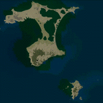
FSX Scenery FRENCH POLYNESIA TUAMOTU ARCHIPELAGO SCENERY Part A
This scenery improves specific area (Tuamotu Archipelago) of FSX.
The archiperago scattered in the northeast of Tahiti island is composed of 78 islands.
I reproduced the 52 islands in the archipelago as add-on senery.
They are islands like a beautiful necklace sprinkled in the tropical ocean.
The French Polynesia Tuamotu Archipelago Scenery X Part A (Tuamotu-X_A)
includes west side of the whole archipelago because of the file size.
This scenery requires Tuamotu-X_B scenery (fpta-xb.zip).
Please be sure to download the Tuamotu-X_B.
When the Tuamotu-X_B scenery is installed together with this scenery,
the huge Tuamotu Archipelago including all of "The Chain Islands" will appear.
By Kazuo Kawamura
| Filename: | The_French_Polynesia_Tuamotu_Archipelago_Scenery_X.zip |
| License: | Freeware, limited distribution |
| Added: | 27th February 2010, 07:36:22 |
| Downloads: | 11,011 |
| Author: | Kazuo Kawamura |
| Size: | 81.3 MB |
| Category: Flight Simulator X - Scenery | |
| Mayaguana (MYMM) - The Bahamas |
|
Images related to this file:
File Description:
Mayaguana is the easternmost island in the Bahamas with Bahamasair providing Nassau and Inagua air connections. The airport utilizes part of an abandoned 11,000 foot USAF runway. The runway is listed as 7300 foot long, but 2400 feet on the east end is closed indefinitely. A new terminal building was completed, but no apron or taxiway connects it to the runway so it is unoccupied. Construction was started on another terminal, apron and taxiway as well as runway repaving, but the project is currently abandoned. All of the aforegoing is represented by this scenery. The scenery includes custom scenery objects; placement of library objects and landclass changes. Scenery is based on Bing Maps and photos taken locally, and it is optimized for use with UTX-TAC.
| Filename: | Mayaguana_MYMM__The_Bahamas.zip |
| License: | Freeware |
| Added: | 20th April 2013, 20:18:45 |
| Downloads: | 1,120 |
| Author: | Art Poole |
| Size: | 1.04 MB |
| Category: Flight Simulator X - Scenery | |
| Chatham Islands: Updated Airports, Landclass, Water Data, and Flight Plans |
|
Images related to this file:
File Description:
This project significantly updates New Zealand's Chatham Islands and includes more accurate coastlines, lakes, road and river data, as well as corrected landclass and a fully updated Chatham Islands/Tuuta Airport (NZCI). Napier (NZNR) aprons and terminal are also updated to more closely reflect the actual airport and accommodate Air Chathams, and the Pitt Island Airstrip (NZPI) is added to FSX. All updates were done in a manner which carefully aligned airport data with current satellite imagery. These airports are served by Air Chathams. Scenery was created using Airport Design Editor X v1.47.07, SBuilderX 3.13, and the FSX Object Placement Tool. Scenery objects were added and modified from stock FSX scenery to resemble as closely as possible the actual airports.
| Filename: | Chatham_Islands_Updated_Airports_Landclass_Water_D.zip |
| License: | Freeware |
| Added: | 8th July 2011, 21:44:02 |
| Downloads: | 1,674 |
| Author: | Carlyle Sharpe |
| Size: | 17.78 MB |
| Category: Flight Simulator X - Scenery | |
| Airport update for Naha Intl - ROAH - Okinawa, Japan |
|
Images related to this file:
File Description:
This is a reasonably accurate and up-to-date version of Naha Intl Airport and made only for FSX users, not suitable for use in P3D: This update now includes the new island runway 18R/36L with ILS approaches, the main runway corrected to 18L/36R and the approaches corrected for it, a new international terminal with all gates numbered correctly, assigned parking as per their website where possible with extra overflow parking, new control tower, aprons, taxiways and taxi signs updated to the latest charts, extra fuel trucks, support vehicle roads rebuilt and many other scenery improvements and objects added, airport views are from the roof of the new control tower (when in tower view) please view the readme before installation
| Filename: | Airport_update_for_Naha_Intl__ROAH__Okinawa_Japan.zip |
| License: | Freeware, limited distribution |
| Added: | 21st June 2021, 17:46:22 |
| Downloads: | 17,799 |
| Author: | Ray Smith |
| Size: | 1.88 MB |
| Category: Flight Simulator X - Scenery | |
| The French Polynesia Tuamotu Archipelago Scenery X Part B (Tuamotu-X_B) |
|
File Description:
FSX Scenery FRENCH POLYNESIA TUAMOTU ARCHIPELAGO SCENERY Part B
This scenery improves specific area (Tuamotu Archipelago) of FSX.
The archiperago scattered in the northeast of Tahiti island is composed of 78 islands.
I reproduced the 52 islands in the archipelago as add-on senery.
They are islands like a beautiful necklace sprinkled in the tropical ocean.
The French Polynesia Tuamotu Archipelago Scenery X Part B (Tuamotu-X_B)
includes east side of the whole archipelago because of the file size.
This scenery requires Tuamotu-X_A scenery (fpta-xa.zip).
Please be sure to download the Tuamotu-X_A.
When the Tuamotu-X_A scenery is installed together with this scenery,
the huge Tuamotu Archipelago including all of "The Chain Islands" will appear.
By Kazuo Kawamura
| Filename: | The_French_Polynesia_Tuamotu_Archipelago_Scenery_X.zip |
| License: | Freeware, limited distribution |
| Added: | 27th February 2010, 07:38:01 |
| Downloads: | 11,012 |
| Author: | Kazuo Kawamura |
| Size: | 78.1 MB |
| Category: Flight Simulator X - Aircraft Repaints, Textures and Modifications | |
| Cessna C172P (SX-AEW) |
|
Images related to this file:
File Description:

This is a representation of SX-AEW, of the Dekeleia Aeroclub based in Tatoi LGTT, north of Athens. It is used both for training and for flights by all club members holding a PPL. It is also available for pleasure flights and initiation flights for non members. The real one also has extended fuel tank capacity for 6 hours endurance.
The actual plane is an older "P" model with carburetor equipped engine so there are several model differences from the "R" represented by A2A including antennae, and very different cockpit with no headrests and different door interior and instrument panel. The tinted cabin glass has been reproduced in the repaint.
| Filename: | Cessna_C172P_SXAEW.zip |
| License: | Freeware |
| Added: | 18th September 2013, 00:16:55 |
| Downloads: | 342 |
| Author: | Vassilios Dimoulas |
| Size: | 21.71 MB |
| Category: Flight Simulator X - Scenery | |
| X3SY - RAF Saltby - Leicestershire, England |
|
File Description:
RAF Saltby (ICAO X3SY)was a World War II airfield in Leicestershire, England. The airfield is located approximately 8 miles (13 km) northeast of Melton Mowbray; about 90 miles (140 km) north-northwestof London.
It was opened in 1942, and was used by both the Royal Air Force and United States Army Air Forces. During the war it was used primarily as a transport airfield. Like many airfields of the time it closed after the war in 1945 but kept in reserve until 1955.
Today the remains of the airfield are located on private property and, now known as Saltby Airfield, is used primarily for gliding.
Source: Wikipedia
| Filename: | X3SY__RAF_Saltby__Leicestershire_England.zip |
| License: | Freeware |
| Added: | 27th April 2016, 15:39:01 |
| Downloads: | 130 |
| Author: | Terry Boissel |
| Size: | 1.36 MB |
| Category: Flight Simulator X - Scenery | |
| RAF Wendling - Norfolk, England |
|
File Description:
RAF Wendling is a former Royal Air Force station located 4 miles (6.4 km) north west of East Dereham, Norfolk, England. Opened in 1942, it was used by both the Royal Air Force (RAF) and United States Army Air Forces (USAAF). During the war it was used primarily as a bomber airfield, being the home of the United States Army Air Forces Eighth Air Force 392nd Bombardment Group. After the war, it was used by the RAF as a standby airfield before being finally closed in 1961 and returned to agriculture. With the end of military control the airfield has become a turkey farm.
| Filename: | RAF_Wendling___Norfolk_England.zip |
| License: | Freeware |
| Added: | 16th February 2016, 17:37:49 |
| Downloads: | 195 |
| Author: | Terry Boissel |
| Size: | 197.67 KB |
| Category: Flight Simulator X - Scenery | |
| RAF Fulbeck - Newark-on-Trent - Nottinghamshire, England |
|
File Description:
RAF Fulbeck is a former Royal Air Force station located 6.3 miles (10.1 km) east of Newark-on-Trent, Nottinghamshire and 10.9 miles (17.5 km) west of Sleaford, Lincolnshire, England.
The airfield is located about 106 miles (171 km) north-northwest of London and was opened in 1940 when it was used by both the Royal Air Force and United States Army Air Forces. During the war it was used primarily as troop carrier airfield for airborne units. It was closed in 1948 and was no longer used by the military and is now privately owned. You will require addon sceneries - see the included readme file for details.
| Filename: | RAF_Fulbeck__NewarkonTrent__Nottinghamshire_Englan.zip |
| License: | Freeware |
| Added: | 13th October 2015, 13:51:01 |
| Downloads: | 307 |
| Author: | Terry Boissel |
| Size: | 71.02 KB |
| Category: Flight Simulator X - Scenery | |
| 6I2 - Lebanon-Springfield Airport - Kentucky, USA |
|
Images related to this file:
File Description:
Lebanon-Springfield Airport (FAA LID: 6I2), a public use airport in Washington County, Kentucky (KY), USA. It is located three nautical miles (6 km) south of Springfield in Washington County) and north of Lebanon (in Marion County). The airport is owned by Marion and Washington Counties. The scenery contains seasonal ground textures for winter, spring, summer, autumn and night; autogen and default scenery objects of FSX plus a modified AFCAD file. Tested with FSX: SE on Windows 10. Version 1.1 contains fixes for the terrain aswell as corrected scenery objects.
** Do not use this version with FreeMesh X - USA; use 6I2_FMX.zip instead **
By Peregrine Simulations
| Filename: | 6I2__LebanonSpringfield_Airport__Kentucky_USA.zip |
| License: | Freeware, limited distribution |
| Added: | 21st February 2018, 23:36:38 |
| Downloads: | 250 |
| Author: | Peregrine Simulations |
| Size: | 104.1 MB |
© 2001-2026 AVSIM Online
All Rights Reserved
Privacy Policy |