
Where Flight Simulation Enthusiasts Gather from Around the World!
AVSIM Library - Search Results

| Category: Flight Simulator X - AI Aircraft | |
| Corendon Dutch Airlines Boeing 737 MAX 9 |

|
Images related to this file:
File Description:

Corendon Dutch Airlines Boeing 737 MAX 9. There are 2 separate texture for FSX and FS9. To be used with The AIA_737_MAX_9 model available separately. This is an AI only aircraft. If you are looking for a topic about painting airplanes, preview, flight plan, go to www.aitraffic.ch By Kamil Fryzol
| Filename: | Corendon_Dutch_Airlines_Boeing_737_MAX_9.zip |
| License: | Freeware |
| Added: | 2nd May 2021, 17:25:53 |
| Downloads: | 292 |
| Author: | Kamil Fryzol |
| Size: | 6.31 MB |
| Category: Flight Simulator X - AI Aircraft | |
| FlightLink ATR 72-500 (OSP ATR 72-500) |
|
Images related to this file:
File Description:

FlightLink ATR 72-600. There are 2 separate texture for FSX and FS9. To be used with The AI OSP 72-500 model available separately. This is an AI only aircraft. If you are looking for a topic about painting airplanes, preview, flight plan, go to www.aitraffic.ch By Kamil Fryzol
| Filename: | FlightLink_ATR_72500_OSP_ATR_72500.zip |
| License: | Freeware |
| Added: | 29th September 2023, 14:18:23 |
| Downloads: | 141 |
| Author: | Kamil Fryzol |
| Size: | 1.97 MB |
| Category: Flight Simulator X - AI Aircraft | |
| British Airways Boeing 767-336/ER |
|
Images related to this file:
File Description:
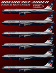
British Airways Boeing 767-336/ER for retro AI traffic, with 6 variations of the Landor fleet, utlizing the FAIB 767-300 RR model set. This package includes FS9 32-bit and FSX/P3D 2048 DDS DXT5 textures. Aircraft model and master paint kit by Erez Weber, repaints by Michael Pearson.
| Filename: | British_Airways_Boeing_767336ER.zip |
| License: | Freeware |
| Added: | 24th February 2019, 04:16:31 |
| Downloads: | 455 |
| Author: | Michael Pearson |
| Size: | 13.17 MB |
| Category: Flight Simulator X - Scenery | |
| Sphinx International Airport HESX Egypt |
|
Images related to this file:
File Description:
Sphinx International Airport HESX is new airport located western side of Cairo
adjacent and share some infrastructure with HECW airbase afcad file added for update,
Apron for 8 large category aircraft numbered in the correct order as chart
The airport reflect current satellite imagery and positioning ,
it should work for p3d
| Filename: | Sphinx_International_Airport_HESX_Egypt.zip |
| License: | Freeware |
| Added: | 9th January 2019, 17:49:21 |
| Downloads: | 1,337 |
| Author: | Mohamed Salamoni |
| Size: | 11.24 MB |
| Category: Flight Simulator X - Scenery | |
| NRAO - Karl G. Jansky Very Large Array |
|
Images related to this file:
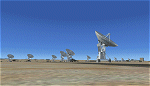
File Description: The VLA or "Jansky Array", managed by the National Radio Astronomy
Observatory (NRAO) consists of 27 independent radio telescope dishes, each with
a diameter of 82 feet and weight of over 200 tons. Each antenna is found along
the three arms of a track shaped in a Y configuration measuring 13 miles long.
Using the rail tracks that follow each of these arms the antennas can be
physically relocated to a number of prepared positions. At one point, the arms
intersect with U.S. Route 60 which passes right through the middle of the array.
It has been featured in numerous films, such as Armageddon, Independence Day,
Terminator Salvation, a Bon Jovi music video, and was featured most prominently
-and correctly- in the Carl Sagan novel Contact, as well as the film of the same
name. Also updated is the closest airport to the VLA - Magdalena, NM - N29. It's
a small dirt strip a few miles to the east, between Socorro and the VLA. It
serves as a nice staging area for flights to the VLA. Includes a helipad startup
location with NM99 ident. Scenery by Jason L. Terry. For FSX Acceleration.
| Filename: | NRAO__Karl_G_Jansky_Very_Large_Array.zip |
| License: | Freeware |
| Added: | 23rd August 2014, 11:18:02 |
| Downloads: | 409 |
| Author: | Jason L. Terry |
| Size: | 3.18 MB |
| Category: Flight Simulator X - Gauges | |
| Flypad Gauge V2.0 |
|
Images related to this file:
File Description:
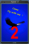
FSX, Flypad Gauge Version 2.0
This gauge has been developed on Win7 for FSX Flight Simulator SP2 or SP1.It should also work with Acceleration, but this is not guaranteed by the author. The gauge is a little extra addon based on the design of a smart phone and provides 9 different displays which are different from all of the standard gauge displays on a regular aircraft panel. It is mainly helpful for the user flying small propeller aircraft, and old timer aircraft.
However, the displays are as well attractive for sim pilots flying modern jet aircraft. Use it as if you just grabbed to your smart phone during a flight and check on the status of your aircraft, or how the terrain awareness situation looks like, how the AI traffic on the radar is, while you proceed with your flight plan. Enjoy the new design of a simple aircraft attitude display during an ILS approach. A new screen for LAT/LON coordination control and distance/bearing calculation has been added to this version in addition with a number of improvements.For credits look at the pdf documentation inside the zip file. By Dietmar Loleit
| Filename: | Flypad_Gauge_V20.zip |
| License: | Freeware |
| Added: | 2nd August 2014, 17:50:45 |
| Downloads: | 778 |
| Author: | Dietmar Loleit |
| Size: | 4 MB |
| Category: Flight Simulator X - AFCAD Files | |
| Southern Cross Airport (C01), NJ |
|
File Description:
Located 03 miles SW of Williamstown, New Jersey on 18 acres of land, Southern Cross is a public turf airstrip with an ample 2400' runway. The runway is hard surfaced in order to allow for AI traffic to use this airport, however the end user must enable flights to arrive/depart from this airfield within their AI traffic program in order for AI to appear here. Tie down space is available north of Runway 09 and fuel is available at the tank next to the hangar. This airport is not lit at night so daytime VFR operations only are recommended. In addition to trees at the ends of both runways, power lines are strung up across there too.
Scenery constructed with use of satellite images/streetview/aerial photos - the author has not been there in person.
This scenery is meant to be used in conjunction with MegaScenery Earth New Jersey/Delaware 004. It is not required, but apron use is minimized to allow satellite scenery to show through as much as possible, and objects are placed based on the MSE textures - lack of it may make scenery look out of place.
| Filename: | Southern_Cross_Airport_C01_NJ.zip |
| License: | Freeware |
| Added: | 25th March 2011, 16:38:00 |
| Downloads: | 192 |
| Author: | Drew Sikora |
| Size: | 630.77 KB |
| Category: Flight Simulator X - AFCAD Files | |
| Stoe Creek Farm Airport (7NJ2), NJ |
|
File Description:
Located 01 miles S of Canton, New Jersey, Stoe Creek Farm is a private turf field 1725' in length. The runway is largely clear of obstructions although on approach for Runway 05 you will deal with 20-30' trees a few hundred feet back from the threshold and there are transmission towers along the approach corridor to Runway 23 you should watch out for. The runway does have edge lighting, although the windsock is not lit at night and daytime VFR is still recommended. There are no services for transient craft at this airfield. Since you will be landing on terrain, it is recommended that your mesh complexity is set as high as possible.
Scenery constructed with use of satellite images/streetview/aerial photos - the author has not been there in person.
This scenery is meant to be used in conjunction with MegaScenery Earth New Jersey/Delaware 004. It is not required, but apron use is minimized to allow satellite scenery to show through as much as possible, and objects are placed based on the MSE textures - lack of it may make scenery look out of place.
| Filename: | Stoe_Creek_Farm_Airport_7NJ2_NJ.zip |
| License: | Freeware |
| Added: | 14th February 2011, 18:32:24 |
| Downloads: | 163 |
| Author: | Drew Sikora |
| Size: | 700.91 KB |
| Category: Flight Simulator X - AFCAD Files | |
| Weiss Farm Airport (JY24), NJ |
|
File Description:
Located 02 miles W of Allamuchy, New Jersey on 264 acres of land, Weiss Farm Airport is a private turf strip 1800' in length. The published width is 50' but you really have closer to 100' to play with. There are no services offered to transient aircraft but you can start parked next to the barn if you wish to taxi out to the runway. No hard surfaced runway is used to have your terrain mesh set as high as possible the start of Runway 23 is a bit slanted and bumpy so you may want to aim long on your approach. The airport is unlit so daytime VFR operations only are recommended.
Scenery constructed with use of satellite images/streetview/aerial photos - the author has not been there in person. This scenery is meant to be used in conjunction with MegaScenery Earth New York 007. It is not required, but apron use is minimized to allow satellite scenery to show through as much as possible, and objects are placed based on the MSE textures - lack of it may make scenery look out of place.
| Filename: | Weiss_Farm_Airport_JY24_NJ.zip |
| License: | Freeware |
| Added: | 21st April 2011, 10:09:59 |
| Downloads: | 192 |
| Author: | Drew Sikora |
| Size: | 593.91 KB |
| Category: Flight Simulator X - Scenery | |
| Whakatane Airport (NZWK), New Zealand |
|
File Description:
Whakatane Airport (ICAO: NZWK) is a small airport serving the town of Whakatane in the Bay of Plenty, New Zealand. It consists of a Asphalt runway flanked with a parallel grass strip and a helipad. While not a particularly busy aerodrome, there are daily movements by Air New Zealand/Eagle Airways Beech 1900Ds, general aviation movements including agricultural aircraft, training flights from the flight school and scenic flights to White Island off the coast of the Bay of Plenty.
Of particular interest is the main terminal, designed by Roger Walker in the modernist style. It has survived in its original form since its construction in the 1970’s and gives a cheerful welcome to visitors disembarking to discover the many natural and cultural attractions in the region.
This particular airport is of interest to me as I began my real world flying training there originally with Scott Air and later with Air Discovery (www.airdiscovery.co.nz) As well as flight training, they also fly scenic tours of White Island and Mount Tarawera.
This Scenery Features: High resolution 10cm imagery for the airport including night map, Custom made buildings including night lighting and window reflections, extensive trees and grass.
| Filename: | Whakatane_Airport_NZWK_New_Zealand.zip |
| License: | Freeware, limited distribution |
| Added: | 24th December 2008, 13:20:53 |
| Downloads: | 3,128 |
| Author: | Tim Barnes |
| Size: | 34.5 MB |


© 2001-2026 AVSIM Online
All Rights Reserved
Privacy Policy |