
Where Flight Simulation Enthusiasts Gather from Around the World!
AVSIM Library - Search Results

| Category: Flight Simulator X - Gauges | |
| Generic Stand-Alone HUD |

|
Images related to this file:
File Description:
A generic stand-alone HUD, which can be used for any aircraft. Some of the displays can be toggled on or off, as desired, by clicking on the buttons at the base of the HUD. The Color button provides a choice of three colors to suit various terrain or weather backgrounds, and for night flight. Written in the old FS 9 xml. Not tested on FS 9, but should work.
| Filename: | Generic_StandAlone_HUD.zip |
| License: | Freeware |
| Added: | 20th August 2011, 19:58:43 |
| Downloads: | 1,224 |
| Author: | Robert Picht |
| Size: | 213.69 KB |
| Category: Flight Simulator X - Gauges | |
| FLTInfo |
|
Images related to this file:
File Description:
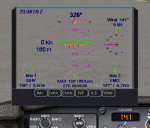
This gauge has been developed for FSX Flight Simulator SP2 or SP1. It should also work with Acceleration, but this is not guaranteed by the author. The gauge provides flight information for the pilot regarding the destination airport in terms of frequencies, runway conditions, altitude, bearing and distance, and basic information about the flight plan like current traveled miles and a estimated calculation about the Top Of Descent (TOD ) decision point. For more information and installation instructions see the documentation inside the zip file.
| Filename: | FLTInfo.zip |
| License: | Freeware |
| Added: | 9th July 2012, 17:18:07 |
| Downloads: | 1,415 |
| Author: | Dietmar Loleit |
| Size: | 498.91 KB |
| Category: Flight Simulator X - Scenery | |
| OKBK Kuwait International Airport |
|
Images related to this file:
File Description:

OKBK Kuwait International Airport . Complete remake of the airport including photoreal terrain for the surrounding area , also new cargo area added with plenty of parking .
| Filename: | OKBK_Kuwait_International_Airport.zip |
| License: | Freeware |
| Added: | 7th May 2011, 22:43:54 |
| Downloads: | 6,901 |
| Author: | Lee Marrow |
| Size: | 56.18 MB |
| Category: Flight Simulator X - Scenery | |
| LIPZ - Venice Marco Polo - Venice, Italy - Update V2 |
|
File Description:
Update for Aerosoft's Venice X. It contains updated taxiways and taxiway signs - You must have Aerosoft's Venice X installed to be able to use it. Updated Version 2.
| Filename: | LIPZ__Venice_Marco_Polo__Venice_Italy__Update_V2.zip |
| License: | Freeware |
| Added: | 13th May 2013, 18:38:30 |
| Downloads: | 4,166 |
| Author: | Emanuele Padoan |
| Size: | 228.11 KB |
| Category: Flight Simulator X - Aircraft Repaints, Textures and Modifications | |
| Atlantic Skies BAe 146-200 |
|
Images related to this file:
File Description:

Repaint of the Premier Aircraft Design BAE 146-200 in Atlantic Skies colours. Please visit the Atlantic Skies virtual airline website at http://atlanticskies.com - One of the oldest, continuously operational virtual airlines (January 1993).
Premier Aircraft Design - Our thanks to PAD for their wonderful aircraft and their service to the Flight Sim community for over 16 years. Please visit their site and send a thank you. http://premaircraft.com
| Filename: | Atlantic_Skies_BAe_146200.zip |
| License: | Freeware |
| Added: | 27th January 2013, 18:10:16 |
| Downloads: | 103 |
| Author: | Brad Hodges |
| Size: | 1.15 MB |
| Category: Flight Simulator X - Scenery | |
| City of Birmingham 1.0 |
|
Images related to this file:
File Description:
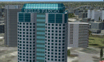
TalonSim is very excited to bring to you City of Birmingham 1.0. Finally Birmingham, Alabama has character as many features about this historic city have been detailed into Microsoft Flight simulator. This scenery package depicts key architectural structures of The Magic City skyline.
| Filename: | City_of_Birmingham_10.zip |
| License: | Freeware, limited distribution |
| Added: | 6th July 2011, 01:16:50 |
| Downloads: | 724 |
| Author: | Dexter Pierre Gray and Talonsim |
| Size: | 3.51 MB |
| Category: Flight Simulator X - Scenery | |
| Quebec Mesh (Lod10), between N56°-N57° and W66°-W77°, Prov. of Quebec (Canada) |
|
File Description:
FSX 38m (Lod10) terrain mesh files of territory included between N56°-N57° and W66°-W77°, province of Quebec, Canada.
| Filename: | Quebec_Mesh_Lod10_between_N56N57_and_W66W77_Prov_o.zip |
| License: | Freeware, limited distribution |
| Added: | 1st March 2008, 14:37:15 |
| Downloads: | 3,040 |
| Author: | Gilles Gauthier |
| Size: | 21.6 MB |
| Category: Flight Simulator X - Aircraft Repaints, Textures and Modifications | |
| Olympic Air Airbus A320 IAE |
|
File Description:
Repaint of the Olympic Air Airbus A320 IAE for the Airbus Black Box Simulator version v0.6. You will need the Black Box Simulator software: http://www.blackboxsimulation.com/ Installation instructions included.
| Filename: | Olympic_Air_Airbus_A320_IAE.zip |
| License: | Freeware |
| Added: | 18th January 2013, 01:02:50 |
| Downloads: | 80 |
| Author: | Ifikratis Kamenidis |
| Size: | 7.31 MB |
| Category: Flight Simulator X - Scenery | |
| South America Mesh Scenery, MeshX_F4 |
|
File Description:
Mesh terrain scenery for the whole continental South America, based on SRTM 90m
dem geotiff files (at: ftp://ftp.glcf.umiacs.umd.edu/glcf/SRTM/Degree_Tiles/),
resampled to 76 meter of horizontal resolution (LOD 9). The new files have
improved the vertical resolution from 16m to 10m, resulting in more details
and accuracy over previous versions. There are 50 files, compatible with FS 9
and FS X, identified in a map by column letter and line number, covering the
contiguous countries and states. Boundaries: N = 5º 37.5' S; S = 11º 15' S;
W = 41º 15' W; E = 33º 45' W;
| Filename: | South_America_Mesh_Scenery_MeshX_F4.zip |
| License: | Freeware |
| Added: | 28th October 2006, 05:54:09 |
| Downloads: | 1,524 |
| Author: | Oséas Dourado and José Lôbo |
| Size: | 32.14 MB |
| Category: Flight Simulator X - Scenery | |
| South America Mesh Scenery, MeshX_F6 |
|
File Description:
Mesh terrain scenery for the whole continental South America, based on SRTM 90m
dem geotiff files (at: ftp://ftp.glcf.umiacs.umd.edu/glcf/SRTM/Degree_Tiles/),
resampled to 76 meter of horizontal resolution (LOD 9). The new files have
improved the vertical resolution from 16m to 10m, resulting in more details
and accuracy over previous versions. There are 50 files, compatible with FS 9
and FS X, identified in a map by column letter and line number, covering the
contiguous countries and states. Boundaries: N = 16º 52.5' S; S = 22º 30' S;
E = 33º 45' W; W = 41º 15' W;
| Filename: | South_America_Mesh_Scenery_MeshX_F6.zip |
| License: | Freeware |
| Added: | 28th October 2006, 15:07:29 |
| Downloads: | 1,510 |
| Author: | Oséas Dourado and José Lôbo |
| Size: | 9.8 MB |
© 2001-2026 AVSIM Online
All Rights Reserved
Privacy Policy |