
Where Flight Simulation Enthusiasts Gather from Around the World!
AVSIM Library - Search Results

| Category: Flight Simulator X - Scenery | |
| CYFB - Iqaluit Airport - Nunavut, Canada |

|
Images related to this file:
File Description:
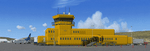
Iqaluit is the capital of Nunavut, a vast northern region that covers almost all of the Canadian North. The airport is of critical importance to the community, especially when ice makes boat travel impossible.
The scenery includes all airport buildings with custom designed and generic buildings nearby. Several typical airlines are represented, both by their flights by their facilities, including First Air, Canadian North, Air Greenland, Ken Borek Air and Keewatin. The Airbus A380 was in Iqaluit in February 2006 for flight testing in cold weather, as do other manufacturers. Airbus will also carry out the same tests for its new A350.
CYFB is also a Canadian Force base. Several units are parked in the military area, in addition to the C- 177 and his escort on ramp 2. A Twin Otter from the RCMP, and some general aviation aircrafts complement the fleet. Six ships are in the scenery: four static and two mobile (AI). Zodiacs and a balloon tourist flow into the bay. These, and the ships AI, start their movements 1100Z. The weather station launches a weather balloon regularly. Three small caribou herds are in the vicinity.
| Filename: | CYFB__Iqaluit_Airport__Nunavut_Canada.zip |
| License: | Freeware, limited distribution |
| Added: | 5th April 2014, 14:37:23 |
| Downloads: | 3,969 |
| Author: | Jean-Pierre Fillion, Pierre Gallant |
| Size: | 16.88 MB |
| Category: Flight Simulator X - Scenery | |
| Chicago Midway Airport V2 |
|
File Description:
This is my second version of Chicago Midway Airport in Chicago IL for FSX. This version was created with Airport Design Editor 1.30, which was designed exclusively for use with FSX. The following improvements have been made: 1. All commercial and GA aircraft will park at their assigned spots. All gates for all airlines are included. 2. The vehicle paths have been redesigned, which should eliminate the problem of airport vehicles using taxiways, which can cause taxiing airplanes to come to a standstill and cause traffic to back up. 3. When in tower view, the view will be from the roof of the control tower, thanks to Airport Design Editor. 4. Crosswind runways have been activated, which will open more runways to airline traffic. This is an optional feature, and will be explained in the Readme file. 5. Several fuel trucks have been added, and should serve departing aircraft quickly. 6. Settings have been changed in ADE so that all jetways will display as long as Scenery Density in FSX is set at Normal or higher. Please be aware that this scenery is for use with FSX only. It will not work with FS9.
| Filename: | Chicago_Midway_Airport__V2.zip |
| License: | Freeware, limited distribution |
| Added: | 30th June 2008, 08:50:03 |
| Downloads: | 4,811 |
| Author: | Patrick Finch |
| Size: | 39.13 KB |
| Category: Flight Simulator X - Scenery | |
| Caribbean, Montserrat, Blackburne airport |
|
File Description:
Blackburne Airport, also known as W.H. Bramble Airport, was a small international airport near the southwest coast of the island of Montserrat, a British Overseas Territory in the Caribbean.
The airport was located near the now-abandoned capital of Plymouth and was destroyed on the 25th of june 1997 by an eruption of the nearby Soufrière Hills volcano.
For several years afterwards, Montserrat had been only accessible by helicopters or boats until July 2005 when the new Gerald's Airport was completed on the north end of the island.
The approach to Blackburne's runway 15 was rather spectacular and difficult. That's why it was very popular among flightsimmers. Ever since the airport was destroyed end of june 1997 it was left out of subsequent releases of Flight Simulator. This scenery gives you the opportunity to fly over there again.
The scenery is provided with some special effects: the volcano Soufrière Hills shows an ash cloud and is erupting from time to time, including sounds, the capital Plymouth is burning at several places caused by debris from the volcano and fires are threatening the airport.
Please read the enclosed readme.txt for information on how and when the secial effects show.
| Filename: | Caribbean_Montserrat_Blackburne_airport.zip |
| License: | Freeware |
| Added: | 26th April 2008, 23:37:32 |
| Downloads: | 1,483 |
| Author: | Jaap van Hees |
| Size: | 186.96 KB |
| Category: Flight Simulator X - Scenery | |
| Teterboro Airport, New Jersey |
|
File Description:
Teterboro Airport is located across the Hudson River in New Jersey, just 12 miles from midtown Manhattan, Teterboro Airport is considered a general aviation reliever airport. As a reliever airport, it does not offer scheduled airline service, nor does it permit operations of any aircraft in excess of 100,000 pounds on any airport surface. Teterboro Airport has five Fixed Base Operators (FBOs), Atlantic Aviation, Jet Aviation, First Aviation, Meridian, and Signature Aviation. Scenery includes Phototexture to cover the unattractive stock FSX airport ground texture. Along with Night, Fall and Winter varience textures. Autogen is placed on top of phototexture in specific areas. ALL airport objects have been placed in proper position to photoscenery. Aprons and taxiways in alignment with photostexture. Supports AI traffic for the pilots who use. Numerous Airport vehicles and stacic aircraft on the gounds. There are a few GMAX scenery objects along with Stock FSX objects. If you have cast ground shadows checked in your display feature, some of the vegetation will show black blocks on its base, so uncheck this if you wish. I designed this for all the Charter and General Aviation pilots out there, including myself.
| Filename: | Teterboro_Airport_New_Jersey.zip |
| License: | Freeware |
| Added: | 7th July 2010, 00:47:37 |
| Downloads: | 1,786 |
| Author: | Eric McCloud |
| Size: | 36.84 MB |
| Category: Flight Simulator X - Scenery | |
| Pease AFB FSX Version 2.0 |
|
Images related to this file:
File Description:
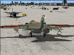
This is Pease AFB, NH. as it was in the late '70s when it was the 509th Strategic Air Command base. Aircraft stationed at Pease AFB were the FB-111A mach 2+ swing-wing bombers, KC-135 refueling tankers and the T-37 trainers.
Included in this scenery package are:
* Parking spots for Military Combat and Cargo aircraft.
* Ground support equipment and vehicles
* AI FB-111A , KC-135, and T-37 aircraft and flight plans
* AI FB-111A's that ATC addresses by tail number
* Custom created static FB-111A and KC-135 aircraft
* Custom buildings included hangers, alert bunker, and control tower.
* Custom Hangers have night lighting and static aircraft with night textures.
* Alert Area with shelters and static FB-111A with SRAMs and KC-135 aircraft
* Custom signs and flags.
* Individual add on transient aircraft and flight plan packages to save frame rates
* AI fighter aircraft have afterburners
* Flyable FB-111A (with textures that match AI and Static aircraft)
* Flyable KC-135 (with textures that match AI and Static aircraft)
Add-ons to scenery available at my website: http://sites.google.com/site/shess0757/home
* Additional AI aircraft with flight plan packages
| Filename: | Pease_AFB_FSX_Version_20.zip |
| License: | Freeware |
| Added: | 10th December 2010, 02:27:53 |
| Downloads: | 1,387 |
| Author: | Steve Hess and Guy Diotte |
| Size: | 30.84 MB |
| Category: Flight Simulator X - Scenery | |
| ENHV - Honningsvag-Valan - Honningsvag, Norway |
|
Images related to this file:
File Description:
ENHV is the most northern airport in Europe (self-promotion of the airport). It it situated on a promontory 46 feet above the sea a few miles southeast of the Nordkap.
This scenery is not a stand-alone-scenery. It is an update of the Airports of Norway (AoN) where ENHV is already included. So AoN has to be installed first to see the buildings and the objects on this airport.
In addition the Nordkap is included with the rock, the museum and the viewing point.
AON you can download here:
http://www.flightsimnorway.com/addons/default.php?funct=dl&pack=aon
Also recommended is to install are the corresponding Photo sceneries AoN Phatopack 1 + 2:
http://www.flightsimnorway.com/addons/default.php?funct=dl&pack=aon
There are some errors corrected In ENHV that occur in the AoN:
1. The altitude is adjusted to the correct height of 46 feet.
2. The sea is where it should be.
3. The land classes are partially adjusted.
4. The town of Honningsvag is involved.
5. The Northern Cape is included, but can be installed separately.
| Filename: | ENHV__HonningsvagValan__Honningsvag_Norway.zip |
| License: | Freeware |
| Added: | 19th October 2015, 18:54:47 |
| Downloads: | 1,925 |
| Author: | Wolfgang Allers |
| Size: | 131.64 MB |
| Category: Flight Simulator X - Scenery | |
| The Bounty Island "Pitcairn" coordinates S 25.03'14 "W 130.06'16" |
|
File Description:
Pitcairn is an island of the Pacific Ocean, the second largest in the British territory of the Pitcairn Islands and the only inhabited area; On it is the capital, Adamstown. The surface area is 4.6 km². On this flap of land, located 2200 km east of Tahiti, settled in Bounty's ammunition in 1790. Geographic coordinates S 25 ° 03'14 "W 130 ° 06'16". My scenario shows exactly where the Bounty ship threw anchor. In the attached package you will find readme to install the scenery
| Filename: | The_Bounty_Island_Pitcairn_coordinates_S_250314_W_.zip |
| License: | Freeware |
| Added: | 31st August 2017, 18:51:53 |
| Downloads: | 245 |
| Author: | Pasquale Marrulli |
| Size: | 1.85 KB |
| Category: Flight Simulator X - Scenery | |
| Alfs UK airfields-Volume 18 |
|
Images related to this file:
File Description:
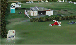
My volume 18 of UK airfields for use with FSX generic scenery consists of Baxterley X3BX, a small tricky grass airfield approximately 2nm WSW of Atherstone and 8nm WSW of Stoke Golding airfield. The Jackaroo glimpsed in the hangar is a local resident. Second is Fowlmere EGMA which is 3.5nm NE of Royston, 10nm SSW of Cambridge and only 4nm W of Duxford airfield and close to the Fowlmere Bird Reserve. Last is something a little larger, Wolverhampton (Halfpenny Green) EGBO and 5nm SE of Bridgnorth.
| Filename: | Alfs_UK_airfieldsVolume_18.zip |
| License: | Freeware |
| Added: | 17th May 2010, 00:07:33 |
| Downloads: | 1,857 |
| Author: | Alf Denham |
| Size: | 31.63 MB |
| Category: Flight Simulator X - Original Aircraft | |
| Avia 51 and Avia 156 |
|
Images related to this file:
File Description:
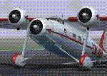
FSX Port Over Tested SP2 and DX9; Functional VC model included; Pkg incl two Aircraft with nice flight models and features four custom era panels in both English and Metric-based gauges, easy-to-read clickable virtual cockpits, elegant cabin interiors, beautifully crafted exterior textures. Authentic Radial Custom sounds included. Two AI aircraft ready to use with AI Flight Plans and scenery for a Czech airport available as a separate download. Gauges used are MS default era gauges and KeDI for the Metric side.
| Filename: | Avia_51_and_Avia_156.zip |
| License: | Freeware |
| Added: | 13th February 2012, 13:36:18 |
| Downloads: | 2,253 |
| Author: | Milton Shupe, Nigel Richards, Matt Wynn, "Oleboy" and John Smith with help from SOH members |
| Size: | 82.21 MB |
| Category: Flight Simulator X - AFCAD Files | |
| KADW - Joint Base Andrews - Camp Springs, Maryland USA v2.2 |
|
Images related to this file:
File Description:
This is an updated version of my December 2011 2.0 release which had runway 1L/19R closed for construction (as was the real Andrews runway). This version has a new runway 1L/19R (196 feet x 11304 feet with 997 foot offset thresholds), an ACA (alert) ramp, east fire station and POL facility, and reworked taxiway and ramp lighting. The approach scenery to runways 1L and 1R now includes The Courses at Andrews (think golf) and the approach to 19R has also been cleaned up.
| Filename: | KADW__Joint_Base_Andrews__Camp_Springs_Maryland_US.zip |
| License: | Freeware |
| Added: | 19th January 2013, 06:17:13 |
| Downloads: | 1,492 |
| Author: | Allen Laughmiller |
| Size: | 34 KB |


© 2001-2026 AVSIM Online
All Rights Reserved
Privacy Policy |