
Where Flight Simulation Enthusiasts Gather from Around the World!
AVSIM Library - Search Results

| Category: Flight Simulator X - Aircraft Repaints, Textures and Modifications | |
| Boeing B-17G (42-102550) |

|
Images related to this file:
File Description:
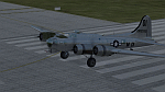
B-17G-55-BO 42-102550 of the 452nd BG. 42-102550 crashed on November 29, 1944, at Charlotte, North Carolina. Icy conditions caused the new B-17 to skid off the end of the runway and come to rest on the Southern Railway tracks as train was approaching. Crew No. 590 of Squadron "S" of the 326th base Unit training pout of MacDill. Irony is they just won "Crew of the Month" so they were allowed to fly anywhere they wanted to, so for their reward, they flew to Charlotte N.C. No injuries, the crew landed long and overran the end of the runway. A great story with a local woman who put a broom in a fire so it could be used to flag down an oncoming train! The plane had to be destroyed to get it off the tracks and the military split up the crew as punishment.
Repaint by Will "dafraz48" Turner, based on the A2A paintkit, March 2015.
| Filename: | Boeing_B17G_42102550.zip |
| License: | Freeware |
| Added: | 11th March 2015, 13:51:53 |
| Downloads: | 93 |
| Author: | Will Turner |
| Size: | 11.67 MB |
| Category: Flight Simulator X - Aircraft Repaints, Textures and Modifications | |
| Lockheed Hudson RNZAF NZ2001 ZX-Z |
|
File Description:
NZ2001 was a Hudson Mk V with construction number 2671. Originally it was AM589 from British Purchasing Mission contracts. Shipped to New Zealand on Limerick, BOC Unit 1 Hobsonville on 19 May 1941 and assembled at No.1 Aircraft depot Hobsonville. Test flown at Hobsonville 01 July 1941. To No.1 GR Squadron Whenuapai 03 July 1941, coded ZX-Z. Later it was coded HQ-A with Gunnery Training School Ohakea during 1944. Issued to Department of Agriculture at Rukuhia March 1948. Probably scrapped at a later date. Repaint for the Alphasim Hudson by Jan Kees Blom.
| Filename: | Lockheed_Hudson_RNZAF_NZ2001_ZXZ.zip |
| License: | Freeware |
| Added: | 5th November 2008, 20:13:34 |
| Downloads: | 371 |
| Author: | Jan Kees Blom |
| Size: | 4.11 MB |
| Category: Flight Simulator X - Scenery | |
| Guaymaral Airport SKGY 2011 |
|
File Description:
Guaymaral Airport (IATA: GAA, ICAO: SKGY) is an airport located in Bogota, Colombia, in the area from which its name was taken, which is located to the north-west of the city, and limits with the towns of Cota and Chia. The airport
handles primarily general aviation traffic, type A and B, only VFR. It's the base for private and commercial pilot training schools like Aeroandes and Aeroclub de Colombia.
This file has the right coordinates, with the apron and characteristics of the airport. The runways were reoriented to the correct direction, runway were resized the gates placed on correct location, Colombia National Police was assigned a correct apron. All the airport charts required to navigate in and out of this airport which are courtesy of: Areonatica Civil de Colombia can be found at www.aerocivil.gov.co/ under Informacion Aeronautica click AIP; on AIP click Aerodromos then click at SKGY.
| Filename: | Guaymaral_Airport__SKGY_2011.zip |
| License: | Freeware |
| Added: | 6th November 2011, 21:15:42 |
| Downloads: | 1,767 |
| Author: | Anwar Gonzalez |
| Size: | 12.06 KB |
| Category: Flight Simulator X - Scenery | |
| YKLN Kulin Town and YJLN Kulin, Jilakin Rock, Western Australia |
|
File Description:
YKLN Kulin Town and YJLN Kulin, Jilakin Rock. Kulin is located in the upper great southern Wheatbelt of Western Australia, the Shire of Kulin covers an area of 4,790 square kilometres. It encompasses the towns of Kulin, Pingaring, Dudinin, Jitarning, and Holt Rock. The Kulin economy is based on agriculture and was settled by pastoralists in 1905. The crosswind runway is actually 7 miles to the east at Jilakin Rock and slopes uphill to the east. For convenience, I have used fictitious YJLN. Jilakin Downs is a Dorper sheep stud farm and the home of the Kulin Bush Races. Dorpers are currently under a cloud in Western Australia as the local abatoirs claim their hair is contaminating the meat and won't accept them. "We welcome air traffic to our 2012 Kulin Bush Races Weekend. A crosswind airstrip is available, with a shuttle bus service to the Jilakin Track. GPS position is S32-39-95 E118-18-71 and the elevation is 950 feet. The strip is 7 nautical miles east of the town of Kulin. Camping and toilets are close to the strip so that you can camp near your plane.
Kulin airstrip is also available for landing and takeoff during the weekend, a shuttle bus is available to take you out to the race track. If this option is chosen please contact Barry West. Please contact Barry West for flying information on 9880 9021" www.kulin.wa.gov.au/tourism_and_local_events/kulin_bush_races/flying_visit.html REQUIRES Blencowe_LibraryKit.zip
REQUIRES blencowe_librarykit_309494.zip (Available HERE)
| Filename: | YKLN_Kulin_Town_and_YJLN_Kulin_Jilakin_Rock_Wester.zip |
| License: | Freeware |
| Added: | 28th February 2013, 13:52:31 |
| Downloads: | 225 |
| Author: | Alan Blencowe |
| Size: | 5.73 MB |
| Category: Flight Simulator X - AFCAD Files | |
| Salem Airfield Airport (NJ74), NJ |
|
File Description:
Located 01 miles E of Salem, New Jersey on 14 acres of land, Salem Airfield is a private turf strip 2200' in length. The hard surface runway has been removed so have your mesh settings as high as possible to get the most out of landing/taking off on actual terrain. The surrounding area has been highly detailed with as much forestation as possible included to block out the horizon as much as possible considering the many open spaces surrounding the airport. Tie downs are located next to the middle of the runway, look for the marker cones or start in any RAMP_GA_SMALL parking locations. A hangar is available as well, and attendant is on call on NAV2 to open the door. You can start inside the hangar in the DOCK_GA parking spot or outside the hangar in the RAMP_GA parking spot. All parking is for aircraft with wingspans no greater than 40 feet. There is no fuel available. The field is lit for night use, but the windsock is not so check your weather before flying in!
Scenery constructed with use of satellite images/streetview/aerial photos - the author has not been there in person.
This scenery is meant to be used in conjunction with MegaScenery Earth New Jersey/Delaware 004. It is not required, but apron use is minimized to allow satellite scenery to show through as much as possible, and objects are placed based on the MSE textures - lack of it may make scenery look out of place.
| Filename: | Salem_Airfield_Airport_NJ74_NJ.zip |
| License: | Freeware |
| Added: | 10th August 2011, 02:05:51 |
| Downloads: | 176 |
| Author: | Drew Sikora |
| Size: | 910.96 KB |
| Category: Flight Simulator X - Aircraft Repaints, Textures and Modifications | |
| Norwegian Air Shuttle Bombardier Dash 8-Q400 (LN-DWF) |
|
Images related to this file:
File Description:

This is a fictional repaint for the Majestic Software, Dash 8 Q400. The livery is the default Norwegian Air Shuttle livery, with a white tail and a "Operated by Wideroe" marker on the nose. This is repainted on the MJC8Q400 Pilot Edition, so I don't know if it will work on the Pro and Training versions.
See more screenshots here: http://krijagrepaints.wix.com/krijag-repaints#!blank/rdkdn
Check out my Facebook page for more repaints!: http://facebook.com/krijagrepaints
Check out my page for other repaint download's: http://krijagrepaints.wix.com/krijag-repaints
| Filename: | Norwegian_Air_Shuttle_Bombardier_Dash_8Q400_LNDWF.zip |
| License: | Freeware |
| Added: | 22nd November 2015, 01:03:35 |
| Downloads: | 909 |
| Author: | Kristian Jaegervand |
| Size: | 1.76 MB |
| Category: Flight Simulator X - Scenery | |
| RNAS Henstridge (HMS Dipper) |
|
File Description:
Royal Naval Air Station Henstridge or RNAS Henstridge (HMS Dipper) is a former Fleet Air Arm base located 7 miles (11 km) west of Shaftesbury, Dorset (Now Somerset) and 12.4 miles (20.0 km) east of Yeovil, Somerset in South West England.
The main part of the land (355 acres) was purchased in August 1941, after which building of the airfield and the marsh lane accommodation site commenced, it was commissioned on April 1, 1943 as HMS Dipper, principally as number 2 naval fighter school, on the 11th September 1942, another 18 acres was acquired at the adjoining gibbs marsh area for an aircraft repair and maintenance site. The design and lay-out of the airfield was quite unique, having 5 runways, 2 of these being east west lay-out (07-25) both 1000 yards long, the northern runway incorporated a dummy deck landing strip, complete with under-ground arresting gear with four above ground arrestor wires, which was a duplicate of that installed on HMS Implacable for training of aircraft carrier landings, these mainly being carried out with the Seafire, a naval version of the spitfire with folding wings. The site also had its own cinema and stage hall
March 1952 the airfield became inactive and was placed under care and maintenance, during 1953 Air whaling (now Bristow group) used the facilities for repairs to the whaling fleet of helicopters until moving out in June 1958.June 1957 it was finally closed as a naval establishment, from 1958-1960 the entire site was sold off. 27 June 1980 the BBC purchased the whole site and applied for planning permission to erect at the airfield a shortwave radio station consisting of 21 self-supporting towers holding aerial arrays and ancillary buildings on a 300-acre site. The station would transmit overseas radio services to Eastern Europe, the Soviet Union and perhaps South America the application failed and the BBC sold the land during January 1987 The airfield is also the home of the wessex strut, a general aviation club formed in January 1977, which holds an annual fly in and other events their first fly-in was on 17 April 1977 and attracted 107 aircraft. As of today the only usable runway is the north 07-25 runway, extant with the concrete dummy deck, and the underground machinery chamber, it is also the home to a large number of light aviation enthusiasts aircraft as well as the Yakolevs aerobatic display team and the Dorset and Somerset air ambulance
The current airfield is operated by EGHS and is an unlicensed airfield. The only usable runway is 07/25 tarmac/concrete 750 mts long x 6 mtr wide. Henstridge radio can be contacted on 130.250 MHz, it can be found at the south eastern stub of the Yeovilton MATZ
Source:Wikipedia
| Filename: | RNAS_Henstridge_HMS_Dipper.zip |
| License: | Freeware |
| Added: | 9th February 2017, 22:14:54 |
| Downloads: | 164 |
| Author: | Terry Boissel |
| Size: | 4.53 MB |
| Category: Flight Simulator X - Flight Plans | |
| OB-11 Richmond Kentucky Low Altitude |
|
Images related to this file:
File Description:
FSX Flight Plan for OB-11 Richmond KY Old IFR high speed low altitude military training route. This is the second in a series of flight plans I will be uploading in the near future. These are great routes for B-52, F-111, B-1B, B-2 A6, A4, Vulcan and any fighter or bomber enthusiasts. Of course you can fly the route with any aircraft of your choice. Included in this package are two spectacular gauges by Karol Chlebowski for TFR flying and Pave Tack which includes many advanced features for bombing, navigation and reconnaissance. These two gauges will greatly enhance your ability to fly these challenging routes and are a great companion of the flight plans. Another option to download Version 2.1 of my mini panel which has all this functionality and more.
| Filename: | OB11_Richmond_Kentucky_Low_Altitude.zip |
| License: | Freeware |
| Added: | 9th July 2011, 00:59:49 |
| Downloads: | 204 |
| Author: | Bill McClellan |
| Size: | 912.61 KB |
| Category: Flight Simulator X - Scenery | |
| Isle of Man (Extras 1) |
|
Images related to this file:
File Description:
Extra 3D objects to fit Photographic Scenery of the Isle of Man. Covers the areas of Lang Ness, Scarlett Point(East), Chicken Rock, Calf of Man and 'mainland' Calf of Man viewing area.
Includes 6 lighthouses, Lang Ness, Chicken Rock and Thousla Rock have night lighting animation effects. Two fog horn effects, Lang Ness and Middle Calf Rock. Lang Ness Hotel and Golf complex, Bunkers and buildings for ex RAF Scarlett Chain Home base together with farm buildings and ruins of buildings on Calf Rock. Models function in FSX, P3D version 1.4, 2.0 and 2.1
| Filename: | Isle_of_Man_Extras_1.zip |
| License: | Freeware, limited distribution |
| Added: | 16th February 2014, 21:07:55 |
| Downloads: | 1,639 |
| Author: | Anthony R Meredith |
| Size: | 11.02 MB |
| Category: Flight Simulator X - Scenery | |
| City of Birmingham 1.1 Update |
|
Images related to this file:
File Description:

TalonSim is pleased to bring to you City of Birmingham 1.1 (an update to City of Birmingham 1.0).Birmingham, Alabama has even more character as many features about this historic city have been detailed into Microsoft Flight Simulator X. This Freeware scenery package depicts key architectural structures of The Magic City skyline. New structures added include, the City Federal Tower, Leer Tower, John Hand Building, Two North Twelve Building, Watts Tower,Empire Building, and BVAA Compass Tower.
| Filename: | City_of_Birmingham_11_Update.zip |
| License: | Freeware, limited distribution |
| Added: | 23rd July 2011, 17:57:37 |
| Downloads: | 1,064 |
| Author: | Dexter Pierre Gray /Talonsim |
| Size: | 6.24 MB |
© 2001-2026 AVSIM Online
All Rights Reserved
Privacy Policy |