
Where Flight Simulation Enthusiasts Gather from Around the World!
AVSIM Library - Search Results

| Category: Flight Simulator X - AFCAD Files | |
| KSBS - Steamboat Springs airport - Colorado, USA |

|
File Description:
Slightly better version of SBS.
I recommend you use Steamboat Mega Pack with this.
| Filename: | KSBS__Steamboat_Springs_airport__Colorado_USA.zip |
| License: | Freeware |
| Added: | 6th September 2015, 00:40:14 |
| Downloads: | 148 |
| Author: | Nick Mathews |
| Size: | 6.87 KB |
| Category: Flight Simulator X - Scenery | |
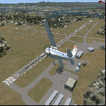
| KMKJ - Mountain Empire Airport - Virginia, USA |
|
Images related to this file:
File Description:
Mountain Empire Airport (ICAO: KMKJ, FAA LID: MKJ) is a public use airport in Smyth County, Virginia, United States.[1] It located nine nautical miles (10 mi, 17 km) northeast of the central business district of Marion (in Smyth County)[1] and 13 nautical miles (15 mi, 24 km) west of Wytheville (in Wythe County).[2] The airport is situated between Interstate 81 and U.S. Route 11 (Lee Highway), near Groseclose. It is owned by Smyth Wythe Airport Commission.
This is a complete re-work of the airport. Added taxiway, additional parking aprons and custom buildings.
Created with Airport Design Editor by ScruffyDuck Software using current FAA documentation and Google Earth measurements, this package offers a replacement for FSX's stock airport. All these enhancements are as close to the real airport as I can get with stock library objects and custom buildings.
| Filename: | KMKJ__Mountain_Empire_Airport__Virginia_USA.zip |
| License: | Freeware |
| Added: | 25th January 2015, 15:55:52 |
| Downloads: | 308 |
| Author: | Wayne Roberts |
| Size: | 339.5 KB |
| Category: Flight Simulator X - Scenery | |
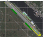
| 6I2 - Lebanon-Springfield Airport - Kentucky, USA |
|
Images related to this file:
File Description:
Lebanon-Springfield Airport (FAA LID: 6I2), a public use airport in Washington County, Kentucky (KY), USA. It is located three nautical miles (6 km) south of Springfield in Washington County) and north of Lebanon (in Marion County). The airport is owned by Marion and Washington Counties. The scenery contains seasonal ground textures for winter, spring, summer, autumn and night; autogen and default scenery objects of FSX plus a modified AFCAD file. Tested with FSX: SE on Windows 10. Version 1.1 contains fixes for the terrain aswell as corrected scenery objects.
** Do not use this version with FreeMesh X - USA; use 6I2_FMX.zip instead **
By Peregrine Simulations
| Filename: | 6I2__LebanonSpringfield_Airport__Kentucky_USA.zip |
| License: | Freeware, limited distribution |
| Added: | 21st February 2018, 23:36:38 |
| Downloads: | 250 |
| Author: | Peregrine Simulations |
| Size: | 104.1 MB |
| Category: Flight Simulator X - Scenery | |
| KHOT - Memorial Springs Airport - Arkansas, USA |
|
Images related to this file:
File Description:
This scenery is an ADE update of the layout at Memorial Springs Airport in Arkansas, USA. This includes, updated parking spots, Adjusted Runway positions and length, Taxiways edited and Added, added buildings, relocation of some objects such as the ILS Transmitter for Runway 23/05 and The VOR, Checkershed and much more. I've tried to make this scenery as realistic as possible with the resources I have. If you have any contributions (e.g. pictures of the Airfield) please don't hesitate to contact me so I can update the Scenery. This is effectively version 1.0 of the scenery. Tested with FSX w/ SP2.
| Filename: | KHOT__Memorial_Springs_Airport__Arkansas_USA.zip |
| License: | Freeware |
| Added: | 23rd November 2015, 14:34:53 |
| Downloads: | 252 |
| Author: | Morgan Thomas |
| Size: | 3.96 MB |
| Category: Flight Simulator X - AFCAD Files | |
| PAKT - Ketchikan airport - Ketchikan, Alaska - USA |
|
Images related to this file:
File Description:
This AFCAD requires payware "Ultimate Terrain Alaska X"!! It will not work without it as it is built on the underlying terrain features and the included file "PAKT_AP.BGL" which has to be renamed or moved to a folder outside the FSX terrain environment. The original file included some errors which I tried to correct. This patch is published with permission.
Changes: The apron layout is corrected including now taxiway "C" leading to GA parking. The pavement has been changed to asphalt as it appears to be when taking aerial pictures as template. The runway got the proper overruns at both sides and the position of the ILS glideslope and localizer has been corrected as well as the DME. The layout of the airport building arrangement including the tower should be now closer to the real world and I added a working jetway. However, I used FSX default objects. As I was dependent on quite rare layout information I just tried to adjust the taxi paths and parking spots probably closer to the reality than before but I did not put any effort to name the parking spots like in real life nor did I take care for taxi signs (only the runway entries got such).
| Filename: | PAKT__Ketchikan_airport__Ketchikan_Alaska__USA.zip |
| License: | Check within download |
| Added: | 25th May 2013, 19:40:38 |
| Downloads: | 439 |
| Author: | Axel Birsul |
| Size: | 1.28 MB |
| Category: Flight Simulator X - Scenery | |
| 0VG - Lee County Airport - Virginia, USA |
|
Images related to this file:
File Description:
Lee County Airport (FAA LID: 0VG) is a public use airport in Lee County, Virginia, United States.It is owned by Lee County and located five nautical miles (6 mi, 9 km) southwest of the central business district of Jonesville, Virginia.
Added taxiways and aircraft parking along with custom buildings. Created with Airport Design Editor by ScruffyDuck Software using current FAA documentation and Google Earth measurements, this package offers a replacement for FSX's stock airport. All these enhancements are as close to the real airport as I can get with stock library objects and custom buildings.
| Filename: | 0VG__Lee_County_Airport__Virginia_USA.zip |
| License: | Freeware |
| Added: | 21st November 2014, 01:40:00 |
| Downloads: | 317 |
| Author: | Wayne Roberts |
| Size: | 102.53 KB |
| Category: Flight Simulator X - Scenery | |
| CJX - Crooked Creek Airport - Alaska, USA |
|
Images related to this file:
File Description:
Crooked Creek Airport (IATA: CKD, FAA LID: CJX) is a public airport located two miles (3 km) south of the central business district of Crooked Creek, in the U.S. state of Alaska.
Increased runway length from 2,029 feet to 3,300 feet and width from 60 feet to 75 feet. Changes were made based on 2010 construction plans.
Created with Airport Design Editor 9x by ScruffyDuck Software using current FAA documentation and Google Earth measurements, this package offers a replacement for FSX's stock airport. All these enhancements are as close to the real airport as I can get with stock library objects and addition of custom models.
| Filename: | CJX__Crooked_Creek_Airport__Alaska_USA.zip |
| License: | Freeware |
| Added: | 23rd October 2014, 11:00:32 |
| Downloads: | 351 |
| Author: | Wayne Roberts |
| Size: | 244.27 KB |
| Category: Flight Simulator X - AFCAD Files | |
| KEZF Shannon Airport, Fredericksburg - Virginia, USA |
|
File Description:
This is an uncontrolled airport in Fredericksburg, VA. Created with Airport Design Editor by ScruffyDuck Software using current FAA documentation and Google Earth measurements, this package offers a replacement for FSX's stock airport. All these enhancements are as close to the real airport as I can get with stock library objects.
| Filename: | KEZF_Shannon_Airport_Fredericksburg__Virginia_USA.zip |
| License: | Freeware |
| Added: | 19th October 2012, 18:08:50 |
| Downloads: | 238 |
| Author: | Wayne Roberts |
| Size: | 6.66 KB |
| Category: Flight Simulator X - AFCAD Files | |
| KDAN - Danville Regional Airport - Virginia - USA |
|
File Description:
All changes made were based on overhead photos of airport and information from the Internet. Changed location and added aprons.
Taxiway was adjusted and lights added. Custom buildings were added.
| Filename: | KDAN__Danville_Regional_Airport__Virginia__USA.zip |
| License: | Freeware |
| Added: | 14th March 2013, 23:41:23 |
| Downloads: | 249 |
| Author: | Wayne Roberts |
| Size: | 612.7 KB |
| Category: Flight Simulator X - AFCAD Files | |
| PAPK - Napaskiak Airport - Napaskiak, Alaska - USA |
|
File Description:
Napaskiak Airport (IATA: PKA, ICAO: PAPK, FAA LID: PKA) is a state-owned, public-use airport located one nautical mile (1.85 km) southwest of the central business district of Napaskiak, a city in the Bethel Census Area of the U.S. state of Alaska.
Changes were made based on 2011 construction plans and photos. Parking area and buildings were changed.
| Filename: | PAPK__Napaskiak_Airport__Napaskiak_Alaska__USA.zip |
| License: | Freeware |
| Added: | 25th May 2013, 21:31:43 |
| Downloads: | 255 |
| Author: | Wayne Roberts |
| Size: | 3.16 KB |
© 2001-2026 AVSIM Online
All Rights Reserved
Privacy Policy |