
Where Flight Simulation Enthusiasts Gather from Around the World!
AVSIM Library - Search Results

| Category: Flight Simulator X - Aircraft Repaints, Textures and Modifications | |
| Guyana Airways 707-323 Adv 1992 |

|
Images related to this file:
File Description:

This is a repaint of the 707-323 Adv. in Guyana Airways colors. The payware 707-300 by Captain Sim is needed for this repaint. Guyana Airways was formed in 1963 in Georgetown Guyana, and a network of scheduled services was developed through the 1960s and 1970s linking Georgetown with 24 domestic destinations, as well as Miami, Boa Vista (Brazil), and such Caribbean spots as Barbados and Port of Spain. Guyana Airways virtually leased all its aircraft, which is why many different aircraft types were used during the airline's operations. In 1978 its fleet consisted of a DC-6A, 2 Hawker Siddeley HS 748s, 2 DHC-4A Caribou, 2 DHC-6 Twin Otters, and 1 Cessna 310. Later on Tu-154s, L-188 Freighters, 2 707-300s, a 737-200, and a 757-200 were added to the fleet. The 707s were used for the direct service between Paramaribo and New York. In 1999 the airline ceased operations due to financial problems. Textures are HiDef 32bit dds. DXT5 dds textures are also included as well. This repaint was tested FSX-SE. It should work on FSX & P3D v1-3.
| Filename: | Guyana_Airways_707323_Adv_1992.zip |
| License: | Freeware |
| Added: | 6th September 2019, 14:59:31 |
| Downloads: | 107 |
| Author: | Ted Giana |
| Size: | 15.18 MB |
| Category: Flight Simulator X - Scenery | |
| Murray river and SE Victoria v2 for ORBX v2. YRIO Robinvale YBRN Balranald YDLQ Deniliquin YLEG Leongatha YYRM Yarram |
|
Images related to this file:
File Description:
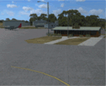
'Murray and SE Victoria v2' is made to match ORBX Australia v2 scenery. Use 'Murray + SE Victoria airports' for ORBX v1 or no ORBX. There are 5 airports. 3 airports near the Murray river in Victoria and NSW - YRIO Robinvale, YBRN Balranald, YDLQ Deniliquin. 2 airports in SE Victoria - YLEG Leongatha, YYRM Yarram. ORBX has done these as they have done every airport included with FSX in Australia to a reasonable standard. If I had not already done them for ORBX V1 I would not have bothered. However these are better than ORBX because the surroundings have been modified to match real life. Towns have been added or shifted. Forests cut down or added. Race courses, sewage treatment ponds and other stuff added. Local obstacles (towers etc) added. There are Included are 2 AI traffic files that cover the airports. These files are for Flight Simulator X. Made using Airport Design Editor using some objects borrowed from Robert Budd's excellent Baccus Marsh and 'Static aircrafts' by Jean-Pierre Fillion. REQUIRED The scenery is designed to interface with ORBX FTX_AU V2 scenery for Australia (payware).
| Filename: | Murray_river_and_SE_Victoria_v2_for_ORBX_v2_YRIO_R.zip |
| License: | Freeware |
| Added: | 15th December 2019, 19:06:10 |
| Downloads: | 317 |
| Author: | Colin Jeffery |
| Size: | 10.06 MB |
| Category: Flight Simulator X - Aircraft Repaints, Textures and Modifications | |
| Universal Airlines Douglas DC-8-54 |
|
Images related to this file:
File Description:
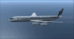
This is a repaint of the DC-8-54 in Universal Airlines colors. The payware DC-8-50-70 by JustFlight is needed for this repaint.
Universal Airlines was a U.S. supplemental carrier that operated from 1966 to 1972. It was based at Willow Run Airport in Ypsilanti, Michigan. It was initially known as Zantop Air Transport. In 1967 the Zantop family sold the airline and it became Universal Airlines. Universal operated military charters for the USAF, in addition to their normal charter operations. The Lockeed L-188 Electras were introduced in 1967, and Universal added DC-8s, both standard and stretched versions, to their fleet in 1969. They also leased three additional DC-8s over the next three years. On June 4, 1970, Universal purchased American Flyers Airline, another supplemental carrier. Costs, led by fuel price increases, prevented the carrier from earning sufficient revenues to sustain the new merger. On May 4, 1972 Universal declared bankruptcy and shut its doors. Its USAF contract, together with the aircraft, were taken over by Saturn Airways.
This repaint was tested on FSX-SE. It should work on FSX & P3D v1-3.
| Filename: | Universal_Airlines_Douglas_DC854.zip |
| License: | Freeware |
| Added: | 9th July 2018, 16:10:25 |
| Downloads: | 107 |
| Author: | Ted Giana |
| Size: | 22.1 MB |
| Category: Flight Simulator X - AFCAD Files | |
| OMAA - Abu Dhabi International Airport - Abu Dhabi, United Arab Emirates |
|
Images related to this file:
File Description:
Abu Dhabi International Airport is an airport in Abu Dhabi, the capital of the United Arab Emirates. The airport is one of the fastest growing airports in the world in terms of passengers, new airline operators and infrastructural development. The airport is now undergoing a US$6.8 billion expansion. As of January 2012, 53 airlines offered service to 85 destinations in 49 countries.
The airport is the second largest in the UAE, serving over 10 million passengers in 2010. It has three operational passenger terminals. Its terminal spaces are dominated by Etihad Airways, which is the United Arab Emirates' second largest air carrier after Emirates.
The new Terminal 3, a US$270 million interim facility, was designed to allow for the airport's passenger growth before the planned opening of the new Midfield Terminal in 2014. Used predominantly by Etihad Airways, the terminal boosted the airport's seven million passenger per year capacity to 12 million. It also added 10 new gates, two of which are Airbus A380 compatible.
Using ADEx 1.51, aeronautical maps and Google Earth this AFCAD is now on par with today's situation.
| Filename: | OMAA__Abu_Dhabi_International_Airport__Abu_Dhabi_U.zip |
| License: | Freeware |
| Added: | 12th January 2013, 22:09:29 |
| Downloads: | 1,694 |
| Author: | Menno C. Robert |
| Size: | 3.62 MB |
| Category: Flight Simulator X - Scenery | |
| LSZB Bern Belp, Switzerland for FSX (P3D) Version1.0 |
|
Images related to this file:
File Description: This scenery is very detailed in design fitting the newest airport layout from 2017. All important buildings are new designed, partly recreated by basicly using objects from the Sketchup Warehouse. Nighttextures are completely integrated. The surrounding area was adapted to the real surroundings by new landclasses. Also the mesh round the airport is adjusted. There are three Photobackgrounds aviable fitting the FSX standardscenery (all seasons), the Switzerland ProX (summer and winter) and Mega Scenery Earth (only summer). RECOMMENDED LIBRARIES:
Many smaller objects, such as people, cars, or static planes in this scenery, are taken from three popular freeware libraries, for which I got the kind permission of the authors. If these libraries are not installed, many objects are not visible! The following libraries are used: 1. FS-Piloten_Objektlibrary:
http://www.fs-piloten.de/thread.php?threadid=1063 2. FSX_FlightPortLib
http://www.flightport.de/libraries/flightport-library/ 3. 3d People Library and 3d People Library BUGFIX
https://library.avsim.net/search.php?SearchTerm=people+3d&CatID=fsxsd&Go=Search
| Filename: | LSZB_Bern_Belp_Switzerland_for_FSX_P3D_Version10.zip |
| License: | Freeware |
| Added: | 13th June 2017, 00:24:32 |
| Downloads: | 5,225 |
| Author: | Wolfgang Allers |
| Size: | 370.96 MB |
| Category: Flight Simulator X - Gauges | |
| Advanced Radar System 4 (ARS4) |
|
Images related to this file:
File Description:
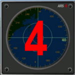
This gauge has been developed for FSX Flight Simulator SP1 or SP2. It
has also been tested with Microsoft Acceleration also, but compatibility is not guaranteed by the author.
This new Advanced Radar System (ARS 4) includes significant new features,
functions and displays for FSX AI traffic. The new key features are:
1)AI traffic display for air targets and boat/ship targets.
2)Auto landing on carrier if the carrier is part of the scenery MECOPS.
3)Allows switching between air target display and boat target display.
4) Provides for air and boat display to optionally insert airport and/or basic terrain display on the screen.
5)Different screen presentations for air and boat targets.
6)Simplified installation procedure.
7)The A2A re-fuel function remains the same as in the ARS2 version.
8)The auto tracking function remains the same as well as in the ARS2 version.
All displays for air, or boat/ship traffic, can be selected in a range of 5, 10, 20, and 40 miles.
For installation and additional information look at the ARS4 documentation inside the zip file. For copyrights and credits please look at the documentation for this gauge.
| Filename: | Advanced_Radar_System_4__ARS4.zip |
| License: | Freeware |
| Added: | 5th March 2013, 15:53:52 |
| Downloads: | 3,814 |
| Author: | Dietmar Loleit |
| Size: | 1.18 MB |
| Category: Flight Simulator X - Scenery | |
| ENHV - Honningsvag-Valan - Honningsvag, Norway |
|
Images related to this file:
File Description:
ENHV is the most northern airport in Europe (self-promotion of the airport). It it situated on a promontory 46 feet above the sea a few miles southeast of the Nordkap.
This scenery is not a stand-alone-scenery. It is an update of the Airports of Norway (AoN) where ENHV is already included. So AoN has to be installed first to see the buildings and the objects on this airport.
In addition the Nordkap is included with the rock, the museum and the viewing point.
AON you can download here:
http://www.flightsimnorway.com/addons/default.php?funct=dl&pack=aon
Also recommended is to install are the corresponding Photo sceneries AoN Phatopack 1 + 2:
http://www.flightsimnorway.com/addons/default.php?funct=dl&pack=aon
There are some errors corrected In ENHV that occur in the AoN:
1. The altitude is adjusted to the correct height of 46 feet.
2. The sea is where it should be.
3. The land classes are partially adjusted.
4. The town of Honningsvag is involved.
5. The Northern Cape is included, but can be installed separately.
| Filename: | ENHV__HonningsvagValan__Honningsvag_Norway.zip |
| License: | Freeware |
| Added: | 19th October 2015, 18:54:47 |
| Downloads: | 1,926 |
| Author: | Wolfgang Allers |
| Size: | 131.64 MB |
| Category: Flight Simulator X - Scenery | |
| Bhutan Airports and Paro Valley |
|
Images related to this file:
File Description:
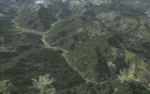
This project adds and updates all of the airports of Bhutan. Bathpalathang (VQBT) and Gelephu (VQGP) are added, Yongphulla (VQ10) is updated and recoded as VQTY, and Paro (VQPR) is fully updated to reflect current satellite imagery. These are all fully functioning AI airports as well. Special attention was given to the entire Paro Valley, and numerous road/river vectors were updated around Gelephu. Accurate coastlines, lakes, road and river data, as well as corrected landclass are provided based on the latest available satellite imagery. They are optimized to fit seamlessly with FTX Vector's roads/water, but they should be fully functional in all FSX configurations.
GA-encoded flight plans for the Buddha Air/Kathmandu charter are provided to enhance service to Paro. NASA SRTM Global 3 arc second terrain mesh is also included for all of Bhutan. Updates were created or rebuilt in a manner which carefully aligned airport data with current satellite imagery, when available. Scenery was created using Airport Design Editor X v1.61.5298, SBuilderX 3.13, and the FSX Object Placement Tool. Scenery objects were added and modified from stock FSX scenery to resemble as closely as possible the actual airports.
| Filename: | Bhutan_Airports_and_Paro_Valley.zip |
| License: | Freeware |
| Added: | 19th January 2015, 06:09:17 |
| Downloads: | 11,437 |
| Author: | Carlyle Sharpe |
| Size: | 21.4 MB |
| Category: Flight Simulator X - Scenery | |
| INS Vikramaditya |
|
Images related to this file:
File Description:

INS Vikramaditya was commisioned into the Soviet Navy as Baku in 1988. It is the third and final remaining Kiev class carrier, the other two being Admiral Kuznetsov and Lioning. Like Lioning, Vikramaditya was purchased from Russia but that is pretty much where the similarity ends. The Chinese quietly bought Varyag under the guise that it would be converted into another floating hotel or casino as had been done several times in the past; then, almost to everyones surprise, they re-built and announced they had an aircraft carrier. India contracted with Russia to complete the refit which began an epic saga of international proportions that encompassed espionage, honey traps and logarithmically expanding budgets. Originally promised for 2008, the latest quotes expect delivery in October/November 2013.
I think the carrier looks very sporty or yacht-like, with the ski-jump bow and the oversized island which has been criticized for being too far into the middle of the deck; it is said to be India's final non-indigenous warship and future flagship to serve for the next 20 to 30 years.
This model is intended for placement with AI Carriers, by Lamont Clark. It has animated radars, working cables, catapults and deck lights. The IFLOS is calibrated, but the catapults will only activate if the airplane deploys a launch bar. The Vikramaditya uses retractable chocks to allow aircraft to develop full thrust, but I could not find a way to lock an aircraft to represent the STOBAR configuration without using catapults. I did not define the elevators because they do not operate and are in the middle of the deck. There are two ships included for escort, the INS Talwar and a Russian Fregat II class ASW destroyer. They have hard decks and night lighting, animated radars, funnel smoke, etc.
| Filename: | INS_Vikramaditya.zip |
| License: | Freeware, limited distribution |
| Added: | 23rd August 2013, 21:43:41 |
| Downloads: | 1,002 |
| Author: | Rick Keller |
| Size: | 18.58 MB |
| Category: Flight Simulator X - Scenery | |
| YNUL Nullagine, Western Australia |
|
File Description:
YNUL Nullagine - Shire of East Pilbara with added ORBX textures. Nullagine is serviced by a gravel airstrip. This facility provides a vital air link. RFDS, Police, and local charter operators all rely on this airstrip for the provision of vital services to the communities. Nullagine is an old goldrush town in Western Australia's Pilbara region. It is located on the Nullagine River 296 km south-east of Port Hedland and 1,364 km north-north-east of Perth on the old Great Northern Highway. The town originated from gold being discovered in the area in 1886 by a prospector, N.W. Cooke. The population increased sharply as a result and by the mid 1890s the community wanted to have a town declared. Lots were surveyed and released in 1897 and the state government gazetted the town in 1899. Nullagine comes from the Aboriginal name of a nearby river, the Ngullagine river; the meaning of the word is unknown. Besides gold other minerals were mined in the area including diamonds and other gemstones. Between 1895 and 1914 the town boomed and contained a number of general stores, three hotels, eight stamp mills and a population of over 3,000. Its population was 1,500 prior to World War II. Now, with the decline of gold mining, only about 200 remain. However the town still attracts fossickers and prospectors who visit the surrounding area, which is particularly rich in minerals such as agate, asbestos, antimony, beryl, chalcedony, copper, jade, jasper, manganese, tiger eye and wolfram. The town is also the place of the Yirrangadji Aboriginal Community. The Martu people make up the bulk of this population. REQUIRES Blencowe_LibraryKit.zip
REQUIRES blencowe_librarykit_309494.zip (Available HERE)
| Filename: | YNUL_Nullagine_Western_Australia.zip |
| License: | Freeware |
| Added: | 28th February 2013, 14:00:15 |
| Downloads: | 293 |
| Author: | Alan Blencowe |
| Size: | 5.72 MB |


© 2001-2026 AVSIM Online
All Rights Reserved
Privacy Policy |