
Where Flight Simulation Enthusiasts Gather from Around the World!
AVSIM Library - Search Results

| Category: Flight Simulator X - Aircraft Repaints, Textures and Modifications | |
| North American P-51D Mustang "February" (N351MX) |

|
Images related to this file:
File Description:
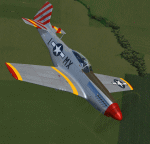
A repaint only for the payware Warbirdsim product 'Mustang Tales'. This repaint depicts the restored P-51D-30-NA 44-74391, "February", registered N351MX. This aircraft was delivered to the USAAF on May 23, 1945, too late to see action in WWII. The aircraft served state-side in the post-WWII years, with many different fighter squadrons, including the California and Illinois Air National Guard. In 1958, the aircraft began service with the Guatemalan Air Force, where it remained until 1972 when it was purchased as a civilian flyer and brought back to the U.S. For years the aircraft was stored in Texas until being sold in 2000 and restoration work began. Owned by film maker Chris Woods, the aircraft was restored in the markings of the P-51D that was flown during WWII by fighter ace Lt. James L. "Jim" Brooks, named "February", as part of the 307th FS, 31st FG, based in Italy. In 2009, the aircraft was sold to the Friedkin family/Comanche Fighters warbird collection, based in Texas, and the aircraft has been an active participant of the Horsemen aerobatic team. This repaint features new bump maps, wheel well, gun bay, and cockpit textures.
| Filename: | North_American_P51D_Mustang_February_N351MX.zip |
| License: | Freeware |
| Added: | 19th April 2013, 00:02:01 |
| Downloads: | 175 |
| Author: | John Terrell |
| Size: | 29.95 MB |
| Category: Flight Simulator X - Original Aircraft | |
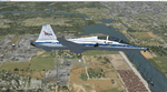
| F-15 S/MTD |
|
File Description:
This is my second release for the FS community.
The F-15 S/MTD is a STOL variant of the all-weather tactical
fighter F-15 Eagle. While S/MTD stands for Short take off and landing
/Maneuver Technology Demonstrator, the actual plane has F-18's elevators
as canard wings and a two-dimensional thrust vectoring, which gives the
aircraft an exceptionnal maneuvrability. Developed as a technology
demonstrator, the F-15 S/MTD carried out research for studying the
effects of vectored thrust and enhanced maneuverability. The NASA has
modified an F-15 Eagle by adding canard wings and by replacing the
original engines nozzles by two Pratt & Whitney P/YBBN 20 Degree
two-dimensional thrust vectoring nozzles. The F-15 S/MTD can also
perform the famous "Pugachev's Cobra" maneuver. The same aircraft would
later be used for the F-15 ACTIVE (with three-dimensional vectored
thrust) and for the F-15 IFCS (with three-dimensional vectored thrust
and with improved avionic). Features all the basic animations
(retractable landing gear, steering wheel, working suspension, working
surfaces plus thrust vectoring nozzles and moving engines inlets) and
afterburner. Sorry, no VC.
Model made in Gmax by Thomas Lebel.
| Filename: | F15_SMTD.zip |
| License: | Freeware |
| Added: | 19th February 2008, 00:35:34 |
| Downloads: | 3,266 |
| Author: | Thomas Lebel |
| Size: | 4.85 MB |
| Category: Flight Simulator X - Gauges | |
| PFD for Flight Instrument Panel |
|
Images related to this file:
File Description:
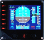
For Saitek Pro Flight Instrument Panel.
This Primary Flight Display (PFD) Glass type gauge provides following utilities:
1. Artificial horizon with sliding bug (yellow).
2. Moving tapes for: Air speed, Altitude, Heading.
3. Detail window for altitude.
4. Needle for vertical speed.
5. Glide slope and Localizer bars, they appear when in range of ILS only.
6. Digital values for: Total Air Temperature (TAT), QNH, Mach number, VOR 1 selected course, VOR 1 bearing, DME 1 range, Radio height altitude up to 2000 feet, above a bar go through the window, vertical speed, a minus sign appears when vertical speed is negative.
7. Autopilot bugs for: Selected altitude, Selected speed, Selected heading. Rmk: Bugs appear only when autopilot ALT, SPD or HDG functions are selected.
8. Display Autopilot functions with Text acronysm in yellow: AP, Autopilot Master On, THR, auto throttle mode engaged, SPD, air speed mode selected, HDG, heading mode selected, NAV, navigation mode selected (VOR 1), APR, approach mode selected, BC, back course mode selected.
9. Knobs functions: Right, allows to change QNH value. Left, allows to move VOR 1 course.
| Filename: | PFD_for_Flight_Instrument_Panel.zip |
| License: | Freeware |
| Added: | 23rd May 2011, 22:37:18 |
| Downloads: | 1,095 |
| Author: | Philippe Verhaege |
| Size: | 249.48 KB |
| Category: Flight Simulator X - AFCAD Files | |
| CYKA - Kamloops Airport / Kamloops, British Columbia, Canada (v1.2) |
|
Images related to this file:
File Description:
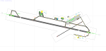
This airport update was made with the latest version of ADE (Airport Design Editor) and made for FSX as a replacement for the stock (default) airport. I've made several changes to the airport which are listed below. All these enchancements are as close to the real airport as I can get with stock library objects. I've used satellite images, terminal photos and maps throughout the whole process so building locations are as accurate as possible. Happy landings in beautiful Canada!
Features:
*Expanded parking apron
*Main terminal building with parking for commercial traffic (renumbered correctly v1.2)
*Seperate parking aprons for GA traffic
*Helipad
*Hangar and other airport buildings added
*Airport vehicles and objects throughout the airport
*Parking lots with static vehicles
*Airport fire station with fire truck
*Static de-icing vehicles & runway plow
*Static aircraft/helicopters
*Corrected communication frequencies (v1.1)
*Recent runway expansion to 8,000ft (v1.2)
*New taxiway Foxtrot,Golf (v1.2)
*New ILS for runway 08 (v1.2)
*Corrected tower elevation bug (v1.2)
(For more information on Endeavourai please visit our site at endeavourai.com or our forums at http://endeavourai.boards.net/)
| Filename: | CYKA__Kamloops_Airport__Kamloops_British_Columbia_.zip |
| License: | Freeware |
| Added: | 9th August 2012, 17:15:56 |
| Downloads: | 736 |
| Author: | Jaison Diaz / Endeavour ai |
| Size: | 127.44 KB |
| Category: Flight Simulator X - Scenery | |
| CYQQ - Comox Valley |
|
File Description:
The Comox valley Airport is located in Comox, East side of Vancouver island, British Columbia, within a three hour drive to most Vancouver Island locations. Comox Valley is, as well, one of many destination for Air Canadian Sun from Air Canadian V.A!
I have re-organised the entire airport layout while keeping the main frame. I have included Parking lot and traffic (static) in the south, the cargo area in the north west, the north east parking, readjusted the 3 helipads to their correct spot, added some parking spot for small and medium aircrafts as well as cargo.
*Important* :Note the ILS fix created by Jim Vile that is suiting as well the airport. Thank you for that! ;)
I have reassigned the main Rwy to 12/30 instead of 11/29 done by FSX including all taxi sign. All maintenance hangar and closed taxiway on the east side.
The push back trucks at the main terminal south and cargo north are set to auto, enjoy a push back! ;)
| Filename: | CYQQ__Comox_Valley.zip |
| License: | Freeware |
| Added: | 8th March 2009, 15:47:24 |
| Downloads: | 2,175 |
| Author: | Daniel Louvet |
| Size: | 545.82 KB |
| Category: Flight Simulator X - Scenery | |
| Baiyun Intl Airport (ZGGG) Guangzhou, China |
|
Images related to this file:
File Description:
This is an accurate and up-to-date version of Baiyun Intl Airport and made only for FSX, do not use in P3D: The new Terminal 2 now added, when Terminal 2 opens it will be home to China Southern Airlines as well as other SkyTeam member airlines such as China Eastern Airlines, Xiamen Airlines, Air France and Korean Airlines, the new runway 2R/20L added with ILS and transitions included for it, all runways now have their correct numbers and the approaches corrected for them, assigned parking as per their website with extra parking including the overnight aprons plus gates added for the A380, the FedEx ramp and buildings updated, the STAG maintenance ramp and buildings also included, the GA ramp now moved to the south of the airport, taxiways and taxi signs updated to the latest charts, extra fuel trucks, support vehicle roads rebuilt, fuel tank farm and many other scenery objects and improvements included for a more realistic look, airport views are from inside the control tower (when in tower view) please view the readme before installation.
| Filename: | Baiyun_Intl_Airport_ZGGG_Guangzhou_China.zip |
| License: | Freeware, limited distribution |
| Added: | 19th February 2018, 23:13:51 |
| Downloads: | 28,625 |
| Author: | Ray Smith |
| Size: | 3.14 MB |
| Category: Flight Simulator X - AFCAD Files | |
| UKOO - Odesa Intl. Odesa, Ukraine |
|
File Description:
Odesa International Airport(IATA: ODS, ICAO: UKOO) is an airport located 7 km (4.3 mi) southwest from the centre of Odesa, Ukraine.
It serves both domestic and international flights. Airport's runways either were or are co-used by the Ukrainian Air Force.
The airport was built in 1961. In 2009, the airport served 651,000 passengers.
The area of Odessa International airport is 570 hectares. The airport concerns to group of the largest airports of Ukraine and connects Odesa by airlines with many cities of Ukraine and CIS, Western Europe, Asia and Africa.
Technical service of airport is based on 2800 square meters area and represented by 4 parking places to provide technical service to 4 planes simultaneously. European standards classify the airport as "class 1".
In May 2007, the airport started construction work that includes extending the main runway. The airport has ILS CAT I status.
The airport charts can be found here.
This file has the right coordenates, with the apron and characteristics of the airport and buildings.
| Filename: | UKOO__Odesa_Intl_Odesa_Ukraine.zip |
| License: | Freeware |
| Added: | 19th October 2012, 23:37:31 |
| Downloads: | 3,035 |
| Author: | Anwar Gonzalez |
| Size: | 484.36 KB |
| Category: Flight Simulator X - Scenery | |
| Scappoose Industrial Airpark |
|
Images related to this file:
File Description:
Presenting KSPB Scappoose, Oregon Industrial Airpark, for FSX only. This is a nice area on the way from Portland, OR to St. Helens,OR around the Sauvie Island area.
ICAO is KSPB as mentioned above. VOWDME is 114.00 60nm range, ILS is 111.10 at 27 nm range.
This includes photo real file at high res for clarity. I made the red barn from pictures I found. One picture is included for comparison. This includes the mailbox and flower arrangement adjacent to it just for fun. Included are a few houses in the barn area and fencing which I did the best I could with what I have at the time.
Default vehicles and planes are added, but not too many so as not to cause frame rates issues. Included are a 55 Ford truck I made and one called fordtruck2 which is not as good as the '55 ford is, but I got in a rush...but it worked well. Enjoy. contact info is in the readme file. Bob
| Filename: | Scappoose_Industrial_Airpark.zip |
| License: | Freeware |
| Added: | 1st August 2012, 13:12:51 |
| Downloads: | 516 |
| Author: | Robert Lacy |
| Size: | 60.24 MB |
| Category: Flight Simulator X - Scenery Design | |
| (Version 2.0) KEFD -Ellington 2025 Refresh FSX (Circa 2006-2010)- Johnson Space Center Houston |
|
Images related to this file:
File Description:
Version 2.0 covers landclass across the entire greater Houston area, with a large increase in LOD. This version significantly tightens up and improves the landclass from version 1.0, and adds a vast amount of scenery objects that brings the Bay Area-KEFD area into the modern era. This improves and adds a highly accurate runway 17 approach with accurate placement of buildings and scenery around the year 2011-modern day. In addition, includes several new files including a new airport/helipad via Houston Clear lake regional airport, T41 La Porte Municipal and surrounding shipping ports, Kemah Boardwalk, and a giant improvement to Johnson Space Center Houston. Rundway 35 and Runway 22 landclass is significantly increased, and more accurate as well. You can fly an accurate VFR approach or set up an ILS for any one of KEFD's runways with ease with this improvement.List of Version 2.0 additions and changes: - I added a ton of scenery objects and tightened up the landclass at Johnson Space Center Houston- NASA Control Center--- Added Talon Park with T38s (via static objects)--- Added Gemeni V rocket and 747 for the shuttle transporter--- And a whole bunch of vegetation, new buildings, and tour buses.- Added Kemah boardwalk and several boat docks- Removed a TON of highrise textures and replaced with medium and large city suburb landclass.- Added Clear Lake regional Hospital with helipad and surrounding scenery by Walter Reed Park- Added El Jardin or "Bayport Container port" with several scenery objects and significantly tightened up landclass.-- Looks great when setting up ILS approach for RWY 22- Tightened up Bay Area BLVD landclass, "adding" University of Houston Clear Lake"-- UHCL was semi already present, just made it more pronounced.- Made Red Bluff road landclass super recognizable!-- Red Bluff road is used to set up VFR approach and or field break for RWY 22 and RWY 17 R.----- Its common to see private jets and the USAF doing a break along Red Bluff road.- Added First Baptist Church, and water tower to Pasadena Convention center- Made Fairmont Parkway pronounced with landclass- Added Houston Port Authority at Morgan's Point--- Another Landmark for the RWY 22 ILS approach, NASA religiously uses this to line up the 10 mile ILS.- Tightened up landclass at Village Grove East and along Fairmont Parkway- Added a TON of scenery objects and landclass corrections for approach of RWY 17 L and 17 R.---- Added Home Depot, Lowes, Walmart Super center, Guitar center etc.---- added South Main Baptist Church--- Bondy Jr High, Turner Elementary, and Pasadena Memorial High School--- Added Saint Luke's Hospital--- Added Hampton Inn Suites and HCA rehab hospital--- Added a ton to the container facility behind best buy and storage facility--- Added smaller churches on RWY 17 approach--- Added a ton of scenery at the base of RWY 17 R, i.e., concrete plant, containers, trucks-- Added gas stations on the corner of beltway 8 and genoa red bluff-- Significantly changed and tightened up landclass at the base of RWY 22 and RWY 17 L and 17 R-- Made several roads and Beltway pronounced------ This decision looks AWESOME at night, really adds demarcation to the roads.**All of this makes the RWY 17 approach super recognizable** RWY 22 approach landclass is much more accurate.- Significantly changed and tightened up landclass near southbelt ellington and interstate 45.- Added Grace Church-- I wanted to do San Jacinto College south, but seemed over kill at that point.- SIGNIFICANTLY tightened up landclass for RWY 35 approach and near baybrook mall.-- Along I45- Added TDECU stadium at the University of Houston Main Campus---- So you can practice flybys for Cougar games!- Added the Battleship at San Jacinto Monument- I also "borrowed" T41 La Porte Municipal's tower camera to make a SWEET view of KEFD.- I included landclass for Sealy Texas this time, as well as my significant enhancements of Austin, Texas greater area as well (optional, but recommended!)---------------------------------------------------------------------------Version 1.0 originally added:- Added the Johnson Space Center Houston, which is now greatly enhanced and blended.- San Jacinto Community College-Central- Pasadena Convention Center- Pasadena Water Treatment Facility- NASA Bouncy Lab- Pasadena Shopping center, now greatly enhanced and blended.- Baybrook Mall and other shopping spots.- Significant Landclass improvements across the entire greater Houston Area File also includes landclass and scenery improvements for the greater Austin, Texas Area (optional), KIAH, KDWH, and Sealy, Texas. Each of these projects combined covers roughly 15,000 square miles of landclass improvement. Allowing you to fly entirely from Houston to Austin, or Houston to San Antonio in accurate landclass. -Enjoy!DJN
| Filename: | Version_20_KEFD_Ellington_2025_Refresh_FSX_Circa_2.zip |
| License: | Freeware |
| Added: | 12th October 2025, 16:15:47 |
| Downloads: | 65 |
| Author: | Dan Nelson |
| Size: | 277.28 MB |
| Category: Flight Simulator X - AFCAD Files | |
| Bridgeport-Cahill Field Airport (6NJ9), NJ |
|
File Description:
Located 01 miles SW of Bridgeport, New Jersey on 167 acres of land, this airport is non-existent in real life, as far as I am able to determine. although it is still listed as Active, no visible trace of anything remotely suitable for a landing strip is visible anywhere in this area. The strip mining operation nearby in some satellite/aerial photos shows a long narrow grass strip that could be used as a runway, but then others show it stripped down to bare dirt as part of the apparent mining operation, and the MegaSceneryEarth textures depict this latter representation as well. So I have simply removed visible evidence of this strip, although FSX will still try to tell you it's there in the airport directory.
Scenery constructed with use of satellite images/streetview/aerial photos - the author has not been there in person.
This scenery is meant to be used in conjunction with MegaScenery Earth New Jersey/Delaware 004. It is not required, but apron use is minimized to allow satellite scenery to show through as much as possible, and objects are placed based on the MSE textures - lack of it may make scenery look out of place.
| Filename: | BridgeportCahill_Field_Airport_6NJ9_NJ.zip |
| License: | Freeware |
| Added: | 10th February 2011, 05:01:38 |
| Downloads: | 197 |
| Author: | Drew Sikora |
| Size: | 209.8 KB |
© 2001-2026 AVSIM Online
All Rights Reserved
Privacy Policy |