
Where Flight Simulation Enthusiasts Gather from Around the World!
AVSIM Library - Search Results

| Category: Flight Simulator 2004 - Scenery | |
| Google Earth Scenery Database for New Zealand |

|
Images related to this file:
File Description:
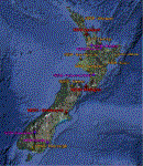
This is a .kmz file showing most of the amazing FS9 sceneries available for NZ (75 or so).
Just double-click on the file and they should show up in GE. Airports are categorised, so you can accurately filter by airport type. Download links are provided for each, as well as a link to a screenshot.
Makes planning a flight a little easier, and perhaps more interesting, as you can often zoom down to street view in GE, and see what the airport looks like!
| Filename: | Google_Earth_Scenery_Database_for_New_Zealand.zip |
| License: | Freeware |
| Added: | 30th March 2011, 01:09:13 |
| Downloads: | 374 |
| Author: | Charl du Toit |
| Size: | 17.54 KB |
| Category: Flight Simulator 2004 - Scenery | |
| Frazier Lake Airpark (1C9) California Scenery |
|
File Description:
This is a scenery upgrade for Frazier Lake, California (1C9). This is part Eight of a series of small airstrip and minor airfield scenery enhancements which are based on real world data from Google Earth. The scenery mainly reflects the appearance of the airpark from directly above. If you are familiar with the place when on the ground, due to the limited number of buildings available it probably looks quite different. There is now however, a water strip for float planes which was missing from the default. It is proper FS9 water so you may land on it. Also, a few images from the net show that the ground varies from green grass to bare earth so I have made four .bgl files for the base texture. Note, I am using Flight1 Ground Environment; the default fields will look different. You must have rwy12 and EZ scenery libraries installed for the buildings to show. Both libraries of objects are free. EZ Library is available at http://www.abacuspub.com/pub/AbacusEZLibraries.exe. Rwy12 and additional EZ Custom libraries from Avsim. Search under Scenery design.
| Filename: | Frazier_Lake_Airpark_1C9_California_Scenery.zip |
| License: | Freeware |
| Added: | 31st March 2006, 01:00:25 |
| Downloads: | 501 |
| Author: | Kim Gowney |
| Size: | 400.27 KB |
| Category: Flight Simulator 2004 - Scenery | |
| Crawford, Colorado Airport Airpark (99V) |
|
File Description:
This changes the FS9 default Crawford, Colorado 99V airport from a 25 x 5200 ft gravel strip to more like it is today with most of its buildings and greatly changed runway-taxiway structure. It also adds Crawford Reservior SE of the airport and a small pond on the airport.
This is a replacement upload for 99Vaprt.zip that had the wrong texture folder in it. Simply download this and follow the improved installation instructions. You need not bother to remove the wrong textures you may have installed from the original upload.
| Filename: | Crawford_Colorado_Airport_Airpark_99V.zip |
| License: | Freeware |
| Added: | 21st April 2004, 18:32:02 |
| Downloads: | 1,221 |
| Author: | Larry Costa |
| Size: | 1020.82 KB |
| Category: Flight Simulator 2004 - Scenery | |
| Alicante LEAL2007 update SP1 |
|
File Description:
Re-upload of the update SP1 files for LEAL2007. Requires Alicante LEAL 2007 to be installed first.
| Filename: | Alicante_LEAL2007_update_SP1.zip |
| License: | Freeware |
| Added: | 22nd January 2010, 10:27:44 |
| Downloads: | 5,574 |
| Author: | Miguel Angel Perez Soria |
| Size: | 8.23 MB |
| Category: Flight Simulator 2004 - Scenery | |
| KFNT Flint, MI. Bishop International Airport. |
|
Images related to this file:
File Description:

KFNT Flint, MI. Bishop International Airport. This airport was completly redone. New terminal, Jetways with correct airline parking for Delta, United, AirTran and American. Removed the old runway 5/23, New FedEx Cargo area, General Aviation area and plenty of details.
Complete RWY12 and EZ Scenery object libraries required for this airport, Please view the READ ME file for details.
| Filename: | KFNT_Flint_MI_Bishop_International_Airport.zip |
| License: | Freeware |
| Added: | 21st September 2012, 19:10:53 |
| Downloads: | 1,149 |
| Author: | Rob Touchtone |
| Size: | 327.07 KB |
| Category: Flight Simulator 2004 - Scenery | |
| Copenhagen City 2.3 |
|
File Description:
Contains several buildings in the Copenhagen area, as well as corrected coastline. Includes both historical buildings - for example the royal castles and the buildings surrounding City Hall Square - as well as newer constructions like the offshore wind turbine farm Middelgrund. Supports FS2002 and FS2004.
| Filename: | Copenhagen_City_23.zip |
| License: | Freeware |
| Added: | 19th August 2003, 22:54:33 |
| Downloads: | 6,107 |
| Author: | Soeren H. Nicolaisen, Kim Dahl, and Lars Moellebjerg |
| Size: | 5.4 MB |
| Category: Flight Simulator 2004 - Scenery | |
| Pawnee, Oklahoma H97 |
|
File Description:
FS2004 scenery - Pawnee, Oklahoma H97
NOT COMPATABLE WITH FS2002
In reality this is a two turf landing strip airport - however, since I have had some family there
(maybe still do) I have taken the liberty of improving the airport by lengthing the R32 to 5,500'
ashphalt, high intensity lighting, fuel service, improved paved parking, and ILS for the "flight
school" and for your ease of flying. NDB has also been added. Plus: progressive taxi & tower.
You will also note sailboats and other craft in the two lakes surrounding Pawnee all of which are autogen FS2004 addons made possible by Robert Furlan.
| Filename: | Pawnee_Oklahoma_H97.zip |
| License: | Freeware |
| Added: | 29th March 2004, 14:09:21 |
| Downloads: | 699 |
| Author: | jimmy R martin |
| Size: | 1.06 MB |
| Category: Flight Simulator 2004 - Scenery | |
| Columbia-Willamette Rivers Fix |
|
File Description:
These flattening files lower the elevated water on the Columbia and Willamette rivers in and around Portland, Oregon. On the Columbia River they start east of Astoria, OR (KAST) and proceed east and south through Portland, OR (KPDX) then east to Cascade Locks, OR (KXZK). On the Willamette River they proceed from Portland south to just north of Aurora, OR (KUAO) ending at the collapsed bridge. Several bodies of water next to the Columbia and Willamette rivers have also been flattened. These files work well with FS default scenery and FS Genesis 38m mesh scenery.
| Filename: | ColumbiaWillamette_Rivers_Fix.zip |
| License: | Freeware |
| Added: | 19th April 2004, 22:19:32 |
| Downloads: | 3,062 |
| Author: | Dan Reynolds |
| Size: | 10.4 KB |
| Category: Flight Simulator 2004 - Scenery | |
| Basepohl (ETAX) |
|
File Description:
Basepohl (ETAX) was one of the military helicopter bases of the former GDR. it´s located in the northeast of Germany and was the homebase of KHG-5.
| Filename: | Basepohl_ETAX.zip |
| License: | Freeware |
| Added: | 13th July 2006, 18:12:05 |
| Downloads: | 1,363 |
| Author: | Frithjof Koch, Torsten Zitzmann, Rolf-Uwe Hochmuth, Volker Löw |
| Size: | 4.01 MB |
| Category: Flight Simulator 2004 - Scenery | |
| SVIE Isla de Coche |
|
File Description:
SVIE Isla de Coche for FS2004
Small airfield on the island
de Coche on the northern coast
of Venezuela near Margarita del
Caribe. Based on GoogleEarth
picture, the surroundings have
been adjusted and objects added.
Needs rwy12 objects.
| Filename: | SVIE_Isla_de_Coche.zip |
| License: | Freeware |
| Added: | 4th February 2008, 21:20:34 |
| Downloads: | 1,185 |
| Author: | Detlev Rohmer |
| Size: | 1.98 MB |
© 2001-2026 AVSIM Online
All Rights Reserved
Privacy Policy |