
Where Flight Simulation Enthusiasts Gather from Around the World!
AVSIM Library - Search Results

| Category: Flight Simulator 2004 - Scenery | |
| Glen Canyon / Lake Powell, Utah 38m Terrain Mesh |

|
File Description:
USGS SRTM30 1 arc-second, resampled to LOD10 (38.2 meters).
This high-resolution terrain mesh is centered at Glen Canyon
National Recreation Area in south-eastern Utah. Coverage area:
From West -111.6° to West -110.2° and North 36.8° to North 38.0°.
It includes the National Recreation Area with Lake Powell,
Navajo Mountain, the Henry Mountains, parts of Capitol Reef
National Park / Grand Staircase Escalante National Monument,
the town of Page in northern Arizona and surrounding areas.
| Filename: | Glen_Canyon__Lake_Powell_Utah_38m_Terrain_Mesh.zip |
| License: | Freeware, limited distribution |
| Added: | 25th January 2004, 20:30:45 |
| Downloads: | 5,424 |
| Author: | Andreas Trawny |
| Size: | 8.31 MB |
| Category: Flight Simulator 2004 - Scenery | |
| Orlando-Sanford SFB / KSFB |
|
Images related to this file:
File Description:

This is a complete remake of Orlando-Sanford International Airport. This project was created from a blank slate. All default buildings, including that wierd interpretation of the main terminal, have been replaced by much more correctly sized, shaped, and placed structures. Many static vehicles litter the landscape bringing this neglected airport to life. This scenery was built with Flight1's Instant Scenery program and AFX.
| Filename: | OrlandoSanford_SFB__KSFB.zip |
| License: | Freeware |
| Added: | 5th September 2011, 14:17:56 |
| Downloads: | 2,790 |
| Author: | William Morgan, www.FRFStudio.net |
| Size: | 23.74 MB |
| Category: Flight Simulator 2004 - Scenery | |
| LEGR Granada-Jaen Federico Garcia Lorca Airport, Spain |
|
File Description:
Scenery for LEGR Granada, Spain. Includes all the changes to the present date: new terminal and new de-icing area. Also includes AFCAD for LEGR, LEGA, LE0B and GEAL (fictitious indicative for the heliport at the Alboran island), marshallers, follow-me cars, 3-D approach lights and static scenery.
| Filename: | LEGR_GranadaJaen_Federico_Garcia_Lorca_Airport_Spa.zip |
| License: | Freeware, limited distribution |
| Added: | 31st August 2006, 00:30:12 |
| Downloads: | 12,999 |
| Author: | Jose M. Barruezo |
| Size: | 8.54 MB |
| Category: Flight Simulator 2004 - Scenery | |
| Antwerp port version 2 |
|
File Description:
This second version of "Antwerp port" is a much improved one.
The port of Antwerp is the main seaport of Belgium and the second of Europe after Rotterdam.
The scenery is made with the Belg7000 scenery version 2.3, which is a scenery improvement for
roads, rivers, citys and much more for the whole of Belgium, as a base scenery.
This means the Belg7000 scenery version 2.3 from Freddy Bridoux, available here at avsim,
must be installed before you install Antwerp port v2.
| Filename: | Antwerp_port_version_2.zip |
| License: | Freeware |
| Added: | 15th December 2005, 22:41:58 |
| Downloads: | 6,104 |
| Author: | Johan Thiers |
| Size: | 3.72 MB |
| Category: Flight Simulator 2004 - Scenery | |
| EBCI - Charleroi Brussels South |
|
Images related to this file:
File Description:
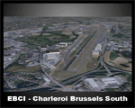
EBCI2010 with new terminal, photoreal ground textures, updated parking positions, new hangars, updated lighting system and new taxiways N
| Filename: | EBCI__Charleroi_Brussels_South.zip |
| License: | Freeware |
| Added: | 11th November 2010, 21:00:49 |
| Downloads: | 6,176 |
| Author: | Mattias Spiessens |
| Size: | 2.98 MB |
| Category: Flight Simulator 2004 - Scenery | |
| New! AVIOSUPERFICI ITALIANE 2026 (The Methuselah Project) - Aviosuperficie di Le Chatelair |
|
Images related to this file:
File Description:
2nd upload and step of ITALIAN AIRSTRIPS 2026 (The Methuselah Project)
Aviosuperficie di Le Chatelair (città NUS, provincia Aosta, regione Valle d’Aosta - Italia)
This airfield is home to the Corrado Gex Aeroclub and the International Mountain Flying School; it is just over 4 km (east) from the Aosta Valley Airport and about 8 km (northeast) from the Chamois Altiporto, the first in Italy at an altitude of 1,820 m. Radio frequency 130.00 active; hangar facilities are available, but not mechanics or refueling.
Pay attention when maneuvering to the nearby power lines, parallel to runway 28; railway line on the opposite side of the power line; hangar opening with Com2 radio freq. 115.
This scenery was created using A.D.E. v1.65 and integrated libraries.
The third and final airfield in the Region is Aereoporto Valle di Aosta, which is already available for FS9 (see the details in the project summary table... https://drive.google.com/file/d/1qT7ZCUhE6ZqCzfjZe9kJM_Y0qhBNNnnN/view?usp=sharing
| Filename: | AVIOSUPERFICI_ITALIANE_2026_The_Methuselah_Project.zip |
| License: | Freeware |
| Added: | 2nd November 2026, 14:51:37 |
| Downloads: | 33 |
| Author: | Aldo Della Vedova and Gian Mario Verga |
| Size: | 3.26 MB |
| Category: Flight Simulator 2004 - Scenery | |
| New! AVIOSUPERFICI ITALIANE 2026 (The Methuselah Project) - Altiporto di Chamois |
|
Images related to this file:
File Description:
1st upload and initial "building block" of ITALIAN AIRSTRIPS 2026 (The Methuselah Project)
Subject: Altiporto Chamois (city Chamois, prov. Aosta, region Valle d’Aosta - Italy)
This mountain airstrip, located at an elevation of 1,757 m (5,761 ft), features a 270 m (885 ft) grass runway and demands exceptional skill during takeoff, approach, and landing (restricted to AG and VGS pilots holding a mountain flying rating).Ground and approach communications are available, but ground refueling is not. Hangarage, and mechanical services are not available.
Scenery made with A.D.E. 1.65 and integrated libraries
enjoy
| Filename: | AVIOSUPERFICI_ITALIANE_2026_The_Methuselah_Project.zip |
| License: | Freeware |
| Added: | 2nd November 2026, 14:51:22 |
| Downloads: | 31 |
| Author: | Aldo Della Vedova and Gian Mario Verga |
| Size: | 1.03 MB |
| Category: Flight Simulator 2004 - Scenery | |
| Central Europe 1961 - Belgium Airports |
|
Images related to this file:
File Description:

This scenery contains 4 Belgian airports as they were in 1961, EBBR Brussels - Zaventem, EBEH Evere-Haren (closed), EBOS Ostend, and EBAW Antwerp - Deurne. The harbor at Antwerp is also modeled. There are moving crash tenders at the active airports. Some estimation was used when pictures could not be obtained. This scenery is intended to supplement the earlier Central Europe 1961 scenery, but is installed into a separate folder. Please install Central Europe 1961 to see all the objects in this scenery.
Requires Central Europe 1961 (central_europe_1961.zip) to be installed first.
| Filename: | Central_Europe_1961__Belgium_Airports.zip |
| License: | Freeware, limited distribution |
| Added: | 29th September 2013, 18:26:41 |
| Downloads: | 3,389 |
| Author: | Harry Biard, Nikko Yaginuma, Jaap de Baare, Wolfgang Gersch, Tom Gibson and Bernard Leuenberger |
| Size: | 16.2 MB |


© 2001-2026 AVSIM Online
All Rights Reserved
Privacy Policy |