
Where Flight Simulation Enthusiasts Gather from Around the World!
AVSIM Library - Search Results

| Category: Flight Simulator 2004 - Scenery | |
| Rome Fiumicino Area 2013 |

|
Images related to this file:
File Description:

Dear Friends simmer, as always taking advantage of the beautiful objects bgl Gianluca Giovannini, I tried to improve with a symmetric pairing of autogen trees / towns / industrial buildings and grass in 3-D, the urban area near the Intercontinental Airport in Rome Fiumicino in the amazing scenery by the ISD project. "With the current integration I have created the town of Fiumicino located on the south west of the airport.The scenery is based videos of real landing and satellite photos availables on the web.
The purpose of visualization tasks is an overall improvement of the work of Leonardo da Vinci airport . The scenery is designed only for ISD project (even better with UTE by Flight one software), but i dont exclude that (which you should remove the file from the folder scenery the bgl Groups houses) or the more recent Payware published by Aerosoft. Most information inside the read me file. Best regards from Italy, Fafo !
| Filename: | Rome_Fiumicino_Area_2013.zip |
| License: | Freeware |
| Added: | 24th February 2013, 01:02:07 |
| Downloads: | 3,482 |
| Author: | Fabio Ferrari "fafo air" |
| Size: | 4.28 MB |
| Category: Flight Simulator 2004 - Scenery | |
| Milano Linate Refresh 2017 |
|
Images related to this file:
File Description:

Hello guys, I proceed with my work retexturizzazione the legendary scenery isd Milan Linate done by ISD.
Basically I worked to make it less "cartoon" the old texture of the airport making it much more plausible real photos the colors of the airport.
To install it is sufficient to copy the texture folder of your Linate isd new textures. (I recommend making back up first).
To complete the work I recommend to install in addition to the original scenario, even my "Linate area" 2013 always available on AVSIM.
It goes without saying that I recommend for the best performance to have autogen to massimo.Ps (not a job of AFCAD but only graphic)
VIVA FS2004! VIVA ITALY
| Filename: | Milano_Linate_Refresh_2017.zip |
| License: | Freeware |
| Added: | 9th March 2017, 04:49:28 |
| Downloads: | 1,947 |
| Author: | fabio ferrari |
| Size: | 7.89 MB |
| Category: Flight Simulator 2004 - Scenery | |
| Sharm el Sheikh, Egypt (Photoreal and Autogen) |
|
Images related to this file:
File Description:
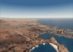
The photoreal scenery of Sharm el Sheikh, the famous holiday destination on the Red Sea cost, with autogen (resorts, villages, palms...) and 3D night lighting, for a more exciting experience of flight.
| Filename: | Sharm_el_Sheikh_Egypt_Photoreal_and_Autogen.zip |
| License: | Freeware |
| Added: | 4th June 2013, 15:10:41 |
| Downloads: | 2,426 |
| Author: | Luca Esposito, Fabio Ferrari |
| Size: | 47.43 MB |
| Category: Flight Simulator 2004 - Scenery | |
| Pan Am Building Textures |
|
File Description:
This Will replace the "MetLife" sign on the Pan Am Building in New York, with the Original "Pan Am" sign... because hey... its still called "The Pan Am Building"
| Filename: | Pan_Am_Building_Textures.zip |
| License: | Freeware |
| Added: | 14th February 2006, 03:07:36 |
| Downloads: | 3,223 |
| Author: | Ben Zwebner |
| Size: | 182.28 KB |
| Category: Flight Simulator 2004 - Scenery | |
| SBGR - Sao Paulo Guarulhos - GRU v3.0 |
|
Images related to this file:
File Description:

This is a coplete rebuild of Guarulhos Int'l Airport. The passenger
terminals have been replaced with custom buildings, and many ramp vehicles sprinkled throughout. The AFCAD file
was built from the default version with AFX. This scenery was built using Flight1's Instant Scenery program.
Update:
This version contains contains much more realistic representations of the main terminals, remote stands, and jetway
layout. Also added are the parked storage aircraft toward the East end of the field and the ones stored on the still
unfinished taxiway A. The parking has been updated as well as some taxiways and sinage. Several other minor corrections
and perfections exist throughout.
| Filename: | SBGR__Sao_Paulo_Guarulhos__GRU_v30.zip |
| License: | Freeware |
| Added: | 20th March 2013, 06:27:25 |
| Downloads: | 20,047 |
| Author: | William Morgan / FRFStudio.net |
| Size: | 12.41 MB |
| Category: Flight Simulator 2004 - Scenery | |
| PAAQ - Palmer Muni - Anchorage, Alaska - USA |
|
Images related to this file:
File Description:
Palmer PAAQ is in Alaska, some 40 miles northeast of Anchorage on the north side of Knik Arm and beside the west bank of the Matanuska River. It is for both GA and commercial aircraft. There are two apron areas, north and south, separated by the east-west runway. The north apron is for the Forestry Service planes and for resident GA tie-down places and hangars, along with maintenance facilities; the southern end of the north apron is for itinerant aircraft. The south apron is almost entirely for commercial companies and again maintenance. The main runway is just under 6,000 feet long, aligned L16-R34 and asphalted and lit, as is the parallel taxiway A. There is also a shorter and parallel runway that is grass and which receives no winter maintenance. The second main runway is 3,600 feet long and aligned 09-27, asphalt and lit and with a parallel taxiway B, also lit. The airport is undergoing a process of upgrading, which explains the varied colours (and age) of resurfaced taxiways. There are adjustment bgl's for two other neighbourhood airstrips, Toad Lake 24AK and Wolf Track 9AK8, which I just discovered buried in nearby holes in the ground; I also revised their runway surfaces.
| Filename: | PAAQ__Palmer_Muni__Anchorage_Alaska__USA.zip |
| License: | Freeware, limited distribution |
| Added: | 4th November 2014, 00:01:43 |
| Downloads: | 447 |
| Author: | Roger Wensley |
| Size: | 22.35 MB |
| Category: Flight Simulator 2004 - Scenery | |
| High Prairie CZHP in Alberta, Canada |
|
Images related to this file:
File Description:
High Prairie is at 1,974 feet asl, 15 miles west of Lesser Slave Lake, 70 miles southeast of Peace River CYPE, and 90 miles east of Grande Prairie CYQU (both already posted). The town has a population of around 2,600 and is based on agriculture, forestry, and oil and gas. The initial impetus behind its growth was the routing of the railroad in 1914. The airport is around 2 miles south of the town, and is fairly basic. There is a single runway just under 4,000 feet of asphalt aligned 07-25. There is a daily flight and around 2010 this was by Central Mountain Air. I believe that there is now a newer terminal building, but a lack of information leaves the older one in place here. There are runway and taxiway lights, unlike some of my recent posts. I made this to fill in the gap between Edmonton and the airports to the northwest such as Grande Prairie.
| Filename: | High_Prairie_CZHP_in_Alberta_Canada.zip |
| License: | Freeware, limited distribution |
| Added: | 9th December 2018, 17:21:09 |
| Downloads: | 120 |
| Author: | Roger Wensley |
| Size: | 3.16 MB |
| Category: Flight Simulator 2004 - Scenery | |
| Etimesgut AB/Ankara(Turkey) Airport (LTAD/ANK) scenery (2016) |
|
Images related to this file:
File Description:
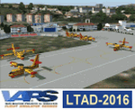
Etimesgut AB/Ankara(Turkey) Airport (LTAD/ANK) scenery (2016) for Flight Simulator 2004 (Fs9). This military airport is in Ankara, the capital of Turkey. Esenboga (LTAC) is very close to the airport. Flight training is given here. The pilot is raised. There are two large and long aprons on either side of the runway. This aprons has a very large number of flight training buildings and hospitals. Bombardier, Gulfstream, Cessna 560XL Excel, Businesss Jet, CL215-Fire fighter, Dash8, Saab-340, CN235, etc. GA airplanes have been configured for parking. Thanks for using. Scenery design by VAPS (vaps.hooxs.com)
| Filename: | Etimesgut_ABAnkaraTurkey_Airport_LTADANK_scenery_2.zip |
| License: | Freeware |
| Added: | 14th April 2017, 07:18:47 |
| Downloads: | 975 |
| Author: | Pilot Hoca (VAPS) |
| Size: | 8.88 MB |
| Category: Flight Simulator 2004 - Scenery | |
| Shea Field CSF7, Casselman Ontario Canada |
|
Images related to this file:
File Description:
Shea Field is a recently-licensed privately-owned grass airfield in Ontario, 25 miles southeast of ottawa, and south of Highway 417. When I visited I was greeeted by the horse, peering around the end of it's stable shed at the corner of apron and runway. I walked over to the house and rang the doorbell and the dog said hello and that exhausted all social contact. The hangar is large but I have no idea what is inside. There was one plane parked on the apron with a skirt of uncut grass so presumably it hasn't flown for a few months. It was a Citabria in what looked like good condition; I don't have a Citabria to park there so I put a Cub. My favourite building is the old barn, leaning to one side as if seeking support for an elbow. To the north there are some farm sheds and grain silos, and to the northwest a tall mast; avoid it. To find the field without a gps follow the 417 and look for the tall mast just west of a major highway wiggle.
| Filename: | Shea_Field_CSF7_Casselman_Ontario_Canada.zip |
| License: | Freeware, limited distribution |
| Added: | 5th August 2012, 13:35:12 |
| Downloads: | 215 |
| Author: | Roger Wensley |
| Size: | 2.62 MB |
| Category: Flight Simulator 2004 - Scenery | |
| Galena PAKP in Alaska |
|
Images related to this file:
File Description:
Galena is a village on the Yukon River, around 30 miles east of the corner where the westward running river turns south. The population is just under 500 and the city is noted for its educational facilities that attract residential students from across the state. Adjacent to the city is the Galena Air Force Station that previously shared the use of the Edward G. Pitna Snr. airport until 2007, when the station was closed and the air force personnel left. The station facilities have been taken over by the community and the airport became the largest state-maintained airport in the interior of Alaska. Substantial resurfacing and finishing work was then carried out, and the new asphalt runway is now 6,000 feet long and aligned 7-25, with VASI at both ends and ILS on 25. There is a secondary gravel runway beside part of the main asphalt runway, and this is treated in radio announcements as if it is not a separate runway and landing or take off are on the adjacent asphalt. The airport is serviced by ERA (now called Ravn) and Wrights Air, with cargo flights by the eternal Everts. Included here is a small modification for Allakaket, which deletes a single remaining stock FS9 taxiway light. The AI included here also provided Allakaket with a Saturday Everts delivery flight, but I neglected to mention that before. A note here about my scenery making. There will not be many more to follow this as I am almost at the end of the photos I either took or found for scenery purposes, plus I expect to move on from FS9 at some point during next year.
| Filename: | Galena_PAKP_in_Alaska.zip |
| License: | Freeware, limited distribution |
| Added: | 27th November 2019, 19:14:00 |
| Downloads: | 257 |
| Author: | Roger Wensley |
| Size: | 13.95 MB |


© 2001-2026 AVSIM Online
All Rights Reserved
Privacy Policy |