
Where Flight Simulation Enthusiasts Gather from Around the World!
AVSIM Library - Search Results

| Category: Flight Simulator 2004 - Scenery | |
| EskisehirAB LTBI 2010_FIX files |

|
File Description:
Removed unnecessary objects, fix file.(Trees, shrubbery etc..)
| Filename: | EskisehirAB_LTBI_2010_FIX_files.zip |
| License: | Freeware |
| Added: | 11th October 2010, 13:10:52 |
| Downloads: | 896 |
| Author: | Neil Wing |
| Size: | 6.71 KB |
| Category: Flight Simulator 2004 - Scenery | |
| Sanikiluaq CYSK in Hudson Bay, Nunavut, Canada |
|
Images related to this file:
File Description:
Sanikiluaq is a village 740 or so inhabitants at N56 30, W79, which means in the southern part of Hudson Bay, close to James Bay. The village is at the north end of Flaherty Island, which is the largest of the Belcher Islands. You might fly there from La Grande Riviere in Quebec (200 miles SSE) or maybe from Moosonee in Ontario at the bottom of James Bay (350 miles SSW). Sanikiluaq village does not feature in FS9, so the first thing to do was to add it; it is the right shape and with around the right number of houses on the right streets but as I wasn't going to model 100+ individual houses just think of it as a hand-made auto-generated village. I also had to move the airfield over beside the river, so there is a DELETE file and a GRASS file and a ROADS file, as well as an AFCAD for AI and a scenery file. And AI for a visiting Air Inuit plane.
| Filename: | Sanikiluaq_CYSK_in_Hudson_Bay_Nunavut_Canada.zip |
| License: | Freeware, limited distribution |
| Added: | 11th October 2010, 23:15:41 |
| Downloads: | 516 |
| Author: | Roger Wensley |
| Size: | 2.21 MB |
| Category: Flight Simulator 2004 - Scenery | |
| Whale Cove CYXN in Hudson Bay, Nunavut, Canada |
|
Images related to this file:
File Description:
Whale Cove is a small village with 300 or so inhabitants at N62 W92 on the west shore of Hudson Bay, 40 miles south of the large airport at Rankin Inlet. The village does not feature in FS9, so the first thing to do was to add it; not all the smaller streets are in place but it is the right shape.
I also had to add the roads, delete the stock airfield background, and add a new background. Plus, although the village isn't near the airfield I thought that if the place is called Whale Cove then the least I could do was create the cove, so there is also "whaleWATER" and "whalecoastDELETE", plus of course the scenery file and the AFCAD and AI.
NOTE: If you have had a problem with textures not showing up in the villages in these northern sceneries there is a note on how to fix it.
| Filename: | Whale_Cove_CYXN_in_Hudson_Bay_Nunavut_Canada.zip |
| License: | Freeware, limited distribution |
| Added: | 15th October 2010, 20:48:12 |
| Downloads: | 420 |
| Author: | roger Wensley |
| Size: | 1.19 MB |
| Category: Flight Simulator 2004 - Scenery | |
| LFCY - Royan Medis, France |
|
Images related to this file:
File Description:
Scenery package for Royan Medis in Western France. This airport has a wonderful skydive club. Detailed scenery with all the buildings, static planes, etc.
| Filename: | LFCY__Royan_Medis_France.zip |
| License: | Freeware, limited distribution |
| Added: | 16th October 2010, 09:12:30 |
| Downloads: | 1,360 |
| Author: | Alexandre Remy |
| Size: | 3.92 MB |
| Category: Flight Simulator 2004 - Scenery | |
| Waskaganish CYKQ in James Bay, Quebec, Canada |
|
Images related to this file:
File Description:
Waskagansh is a village with 2,500 or so inhabitants at N51 28 W78 45 on the southeast shore of James Bay. It was founded in 1668 as Fort Charles (later it became Fort Rupert) and was the first Hudson's Bay Company trading post in the James Bay area. The village's current name means Little House in the Cree language. The village does not feature in FS9 but is included in this scenery with approximately the right shape; just think of it as a hand-made auto-generated village.
I also had to add the roads (the file called "waskROADS"), delete the stock airfield background ("WaskDELETE"), and add a new background ("WaskGRASS") plus of course there is the usual scenery file and the AFCAD and AI. There is also a note in here on what to do about a possible texture problem for the village that I have discussed with two downloaders and solved. I hope.
| Filename: | Waskaganish_CYKQ_in_James_Bay_Quebec_Canada.zip |
| License: | Freeware, limited distribution |
| Added: | 21st October 2010, 23:32:16 |
| Downloads: | 541 |
| Author: | Roger Wensley |
| Size: | 1.38 MB |
| Category: Flight Simulator 2004 - Scenery | |
| Long Beach Airport (Daugherty Field) SP1 |
|
File Description:
The files in this upload provide fixes for the errors that users reported in the Long Beach Airport scenery released on 8th Oct 2010.
| Filename: | Long_Beach_Airport_Daugherty_Field_SP1.zip |
| License: | Freeware, limited distribution |
| Added: | 23rd October 2010, 17:23:31 |
| Downloads: | 3,870 |
| Author: | Shehryar Ansari / Wil Morgan |
| Size: | 278.21 KB |
| Category: Flight Simulator 2004 - Scenery | |
| Waskaganish CYKQ in James Bay, Quebec, Canada - Update |
|
Images related to this file:
File Description:
This update for Waskaganish CYKQ provides the AFCAD that was not included in the original post, and advises on a remedy for a possible village texture problem.
| Filename: | Waskaganish_CYKQ_in_James_Bay_Quebec_Canada__Updat.zip |
| License: | Freeware, limited distribution |
| Added: | 23rd October 2010, 21:40:19 |
| Downloads: | 352 |
| Author: | Roger Wensley |
| Size: | 180.14 KB |
| Category: Flight Simulator 2004 - Scenery | |
| My Water Project V1.2 |
|
Images related to this file:
File Description:

My water Project V-1.2 is a freeware add-on that replaces the sad water textures of Flight Simulator 2004. My water Project V-1.2
- replaces the sea and ocean coral blue with a more realistic blue;
- adds wonderful coral waters;
- adds a pumping effect;
- colours change with the time of day;
- includes a great sun reflection effect and slightly the cloud.
There is no texture change between V1.0 and V1.2, just the new installation program witch now make automatically back up file ! AirTimSimulation Team
| Filename: | My_Water_Project_V12.zip |
| License: | Freeware, limited distribution |
| Added: | 24th October 2010, 10:04:02 |
| Downloads: | 5,404 |
| Author: | AirTimSimulation" |
| Size: | 8.44 MB |
| Category: Flight Simulator 2004 - Scenery | |
| Worland WY Airport (KWRL) |
|
Images related to this file:
File Description:
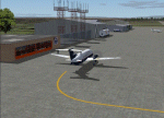
Worland Municipal Airport is located in Worland, WY. Worland is a town of 5000 located in the Big Horn Basin of Northwestern Wyoming. The Airport is served by Great Lakes Aviation which currently has 2 flights daily between Worland and Denver. Great Lakes is affiliated with both United and Frontier Airlines.
This is an fairly accurate representation of the present day Worland Wyoming Municipal Airport. It has the updated location for rwy 16/34 which was moved to the South in about 2006. It also shows the present Pepsi Hanger owned by Admiral Beverages with a door that opens (112.0 on nav2) revealing the company's Challenger Jet.
A special Thank You to David "Opa" Marshall who helped me when I had no idea how to do something. He is also responsible for making the General Aviation AI traffic that you see coming and going at the airport.
| Filename: | Worland_WY_Airport_KWRL.zip |
| License: | Freeware |
| Added: | 25th October 2010, 20:13:59 |
| Downloads: | 432 |
| Author: | Gary Wilson |
| Size: | 292.8 KB |
| Category: Flight Simulator 2004 - Scenery | |
| Puvirnituq CYPX in Hudson Bay, Quebec, Canada |
|
Images related to this file:
File Description:
Puvirnituq is a village of 1,300 or so inhabitants at N60 W77 on the east shore of Hudson Bay. It's name means "Putrid" in Inuit, and there are two different stories about how it got the name. The village does not feature in FS9, but is included in this scenery with approximately the right shape (the coast, even with UT, is not exactly right) so just think of it as a hand-made auto-generated village which gives the airfield a reason for being there. The runway is a very generous 6,300 feet of gravel 148 feet wide, which should be enough for almost anything. I also had to add the roads, delete the stock airfield background and add a new background, plus of course there is the scenery file and the AFCAD and AI.
| Filename: | Puvirnituq_CYPX_in_Hudson_Bay_Quebec_Canada.zip |
| License: | Freeware, limited distribution |
| Added: | 30th October 2010, 13:34:30 |
| Downloads: | 375 |
| Author: | Roger Wensley |
| Size: | 1.72 MB |


© 2001-2026 AVSIM Online
All Rights Reserved
Privacy Policy |