
Where Flight Simulation Enthusiasts Gather from Around the World!
AVSIM Library - Search Results

| Category: Flight Simulator 2004 - Scenery | |
| Long Tieng (LS20A) - secret CIA base in Laos and other small sites (Lima Sites) |

|
Images related to this file:
File Description:
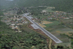
Remake of sceneries from the Virtual Flight Air America. Includes Long Tieng (LS20A), the
secret base of CIA in Laos during the Cold War and other small sites (called Lima Site) to land with your Porter, L-19 and other STOL airplanes. Some runway have an important slop (up to 15 degrees) so be careful!
| Filename: | Long_Tieng_LS20A__secret_CIA_base_in_Laos_and_othe.zip |
| License: | Freeware |
| Added: | 21st April 2010, 19:39:08 |
| Downloads: | 845 |
| Author: | Daniel Gauthier |
| Size: | 7.24 MB |
| Category: Flight Simulator 2004 - Scenery | |
| Libyan military air bases |
|
Images related to this file:
File Description:

This package contain 25 Libya military airport scenery. For fully functionality you need some object libraries (listed inside).
You can download Libyan AI repaints, and flightplans, from this site and from www.militaryaiworks.com.
Inside: HL0M AL BUMBAH NORTH, HL0O AL JUFRA, HLLB BENINA [Benghazi], HLLQ EL BEIDA [LABRAQ], HL0L GAMAL ABD EL NASSER [Tobruk], HLTD GHADAMES EAST, HLGT GHAT,HL0B MARTUBAH, HL0V MISURATA, HLLM MITIGA [UMM AITIQAH], HL0W OKBA IBN NAFA, HLLS SEBHA, HLGD SIRTE [Ghurdabiya-Sirte], HLLT GAMAL ABDEL NASSER, HL0E MATAN AS SARRA.
| Filename: | Libyan_military_air_bases.zip |
| License: | Freeware |
| Added: | 20th March 2011, 20:25:45 |
| Downloads: | 1,736 |
| Author: | Luciano Franchini |
| Size: | 3.05 MB |
| Category: Flight Simulator 2004 - Scenery | |
| RJTT - Tokyo (Haneda) International Airport - Tokyo, Japan - **FIX** |
|
Images related to this file:
File Description:

Fix for FS2004 Scenery Haneda Airport (RJTT). Thanks to the many people who reported missing textures for this scenery which may have caused a failure to load or crashing of the sim! Here are the missing textures files needed. Just place them in your X:\FS9\Scenery\World\Scenery folder and you should be good to go. My apologies for the mispackaging and any frustration this has caused. Also for the delay in posting due to my many errors when uploading this patch.
| Filename: | RJTT__Tokyo_Haneda_International_Airport__Tokyo_Ja.zip |
| License: | Freeware, limited distribution |
| Added: | 20th March 2015, 01:55:18 |
| Downloads: | 3,092 |
| Author: | John Stinstrom |
| Size: | 111.73 KB |
| Category: Flight Simulator 2004 - Scenery | |
| VTBD 2006 |
|
File Description:
VTBD or DonMuang Intl airport is the Thailand main international airport that also serve both of domestic and international flights. There are a lot of traffics are taking off/landing in every second.
| Filename: | VTBD_2006.zip |
| License: | Freeware |
| Added: | 15th January 2006, 00:38:47 |
| Downloads: | 16,014 |
| Author: | Siamavsim.com, Sira I, Polapan S, Teeravuth B, and Krit T |
| Size: | 4.47 MB |
| Category: Flight Simulator 2004 - Scenery | |
| J F Mitchell TVSB on Bequia in the Grenadines |
|
Images related to this file:
File Description:
Bequia island is one of the northernmost of the group of islands known as St Vincent and the Grenadines, just south of St Vincent. Bequia is a small curved island island, 8 miles long and in general less than a mile wide; as a result the resident population is less than 5,000.
There are two main towns, Port Elizabeth (the capital, on the bay) and Paget Farm (close to the airport).
The airport is built on reclaimed land parallel to the beach along the south coast, just west of Paget Farm; the runway is 3,700 feet long. The terminal is fairly new, or appears to be, though it may have just been well cared for. There are connecting flights by SVG to Barbados and the other islands and these are reflected in the AI.
| Filename: | J_F_Mitchell_TVSB_on_Bequia_in_the_Grenadines.zip |
| License: | Freeware, limited distribution |
| Added: | 11th June 2013, 22:56:21 |
| Downloads: | 468 |
| Author: | Roger Wensley |
| Size: | 2.83 MB |
| Category: Flight Simulator 2004 - Scenery | |
| El Paso, Texas KELP |
|
Images related to this file:
File Description:
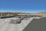
This AI-Package contains several beautiful airplanes: A Boeing-707 GAF, several
Boeing-737: America West, Continental, Delta, South-West and United Airlines which
perform "Domestic Flights" per attached flight plan and two NASA F-5's doing "Touch
and Goes" ones per week.
All the attached outstanding airplanes have been created by well known designers
(see briefing). My part was just to prepare them in order to work in an artificial
intelligent (AI) environment as good as possible.
The excellent El-Paso scenery "elp_photo.zip" from Kevin Burns, available here at the
Avsim library, is required to enjoy this package!
| Filename: | El_Paso_Texas_KELP.zip |
| License: | Freeware |
| Added: | 14th April 2011, 02:27:21 |
| Downloads: | 634 |
| Author: | Klaus Jone |
| Size: | 9.33 MB |
| Category: Flight Simulator 2004 - Scenery | |
| Aspen (KASE), Colorado, Photo-Scenery (FS9 & FSX) |
|
Images related to this file:
File Description:
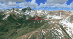
There sure is more than one reason to go to Aspen and this is sure another must-have of my Colorado sceneries. If you're coming IFR there's a couple of very demanding approach procedures. From a LOC/DME to several visual approaches there's everything your heart might desire. Due to the steep and high surrounding terrain these are quiet some hair raisers (see www.airnav.com/airport/KASE). If you're coming VFR then the traffic pattern altitude is 9.005 ft for light aircraft (vs. 9.505 for aircraft 12.500 lbs or more). Weather and wind permitting, RW15 is preferred for all landings (left pattern). RW33 has a right pattern and is preferred for all takeoffs. You even need a written permission to depart RW15. When departing VFR make a right turn to a heading of 360 degrees ASAP for noise abatement and hold this heading for at least 2 miles from the field. And don't forget to enjoy the impressive mountain scenery with two 14ers: Snowmass Mtn. and Castle Pk. to the southwest. This scenery brings you another 3.500 sq km of beautiful Colorado in 4.7m/pix quality. High resolution versions of this scenery for FS9 and FSX (much sharper, but larger and multiple downloads) are available at www.blueskyscenery.com/GNB_South2West2.html . The screenies are taken from the high-res versions, so expect this version to be slightly more blurry. YourDonation@Work: Dedicated to Mark, Markus and Yves.
| Filename: | Aspen_KASE_Colorado_PhotoScenery_FS9__FSX.zip |
| License: | Freeware, limited distribution |
| Added: | 30th January 2010, 17:04:55 |
| Downloads: | 3,578 |
| Author: | Gottfried Razek - blueskyscenery.com |
| Size: | 92.5 MB |
| Category: Flight Simulator 2004 - Scenery | |
| USA Landclass AddOn - Vegetation Part 1 UPDATE 1.5 |
|
Images related to this file:
File Description:
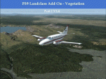
Complete Update, please delete all the old scenery folders. Compatible with Ultimate Terrain, incl. some fixes for UT. Sorry for the update 1.4 called final. Pleas note the readme file. Udate V1.5 concerns mainly British Columbia, the boring LC from CYLW to CYKA to CYWL to CYQZ and to CYXS. Now it is varied, made again with satellite maps. Also change the wrong green LC from KASE (Aspen) to KRIL (Glenwood Springs) and some LC Border correction. BC requires for one LC good replacement textures(026b2.bmp) to enjoy the changes or do it by yourself. Birds Eye View textures includes a good texture. For GEpro Users there is a example picture how to make it with texture 024b2 and 052b2 and a Paintshop Software. For a fast Textureswitch, Batch files are included, also inf and raw files for changing for your according to your taste.
| Filename: | USA_Landclass_AddOn__Vegetation__Part_1_UPDATE_15.zip |
| License: | Freeware |
| Added: | 5th March 2015, 19:32:31 |
| Downloads: | 292 |
| Author: | Markus Balz |
| Size: | 4.01 MB |
| Category: Flight Simulator 2004 - Scenery | |
| Airstrips of South-West France |
|
File Description:
Part two of my "Airstrips of Western Europe" project, these 90+ sceneries are mostly default basic airstrips from FS2004, enhanced with taxiways, parking spaces and aprons as appropriate, to facilitate the activation of lightweight GA AI traffic, primarily over the south-west of France. Hopefully these will allow a degree of continuity between my previous upload (Airstrips of North-West Europe) and the existing freeware releases for Spain and Portugal.
Again, there's no photo-realism here, just a selection of basic 'generic' buildings, more or less accurately sized and placed to reflect the airfield layout as seen on on-line satellite imagery and aerial photography. These buildings have minimal effect on frame-rates, so are ideal for this kind of job. The airfields are aligned as well as possible with the roads etc. in UT Europe and the Genesis Europe mesh, but should mostly be fine in a default installation or other configuration.
A good number of airfields in this area have been neatly implemented in the "Occitania_VFR" package, so I've not duplicated their work.
Also included are some "bonus" sceneries from further north that weren't included in my previous upload. Just copy them over as appropriate if required.
| Filename: | Airstrips_of_SouthWest_France.zip |
| License: | Freeware |
| Added: | 16th July 2024, 18:20:44 |
| Downloads: | 112 |
| Author: | Chris Eve |
| Size: | 274.73 KB |
| Category: Flight Simulator 2004 - Scenery | |
| St Brieuc Wind Farm |
|
File Description:
A recently commissioned 62-turbine windfarm in the Bay of St. Malo.
Written for FS9, using SceneGenX, from data published by the contractors on the internet.
As usual, do what you want with it except charge for it 😉
Enjoy!
| Filename: | St_Brieuc_Wind_Farm.zip |
| License: | Freeware |
| Added: | 31st March 2024, 17:15:14 |
| Downloads: | 62 |
| Author: | Chris Eve |
| Size: | 1.5 KB |
© 2001-2026 AVSIM Online
All Rights Reserved
Privacy Policy |