
Where Flight Simulation Enthusiasts Gather from Around the World!
AVSIM Library - Search Results

| Category: Flight Simulator 2004 - Scenery | |
| Mustique TVSM in the Grenadines |

|
Images related to this file:
File Description:
Mustique island is one of the northernmost of the group of islands known as the Grenadines, just south of Bequia. Mustique is a small island, less than 3 miles long and even at its widest less than a mile wide; as a result the resident population is less than 500. The island is unique in that it is owned by a company. The company is owned, in its turn, by the owners of the 100 or so private villas on the island. The Queen of England is one owner; her participation is balanced out by Jeremy Clarkson.
The airport is at the northern end of the island; the runway is around 3,240 feet long, aligned 09 (and with the southeast trade winds it is most unlikely that you will ever find yourself using 27) and with a steep and displaced threshold of over 900 feet. The displaced threshold is shown but unfortunately FS9 is not capable of coping with anything other than a prefectly flat airport. The terminal is a steel-framed shed with cladding, but is "quaintly" transformed with a palm frond roof etc. There are connecting flights by SVG to Barbados and the other islands and these are reflected in the AI. The airport has no lighting, and flights are obliged to land and depart in daylight hours only, outside of which the airport is closed.
| Filename: | Mustique_TVSM_in_the_Grenadines.zip |
| License: | Freeware, limited distribution |
| Added: | 11th June 2013, 22:57:37 |
| Downloads: | 512 |
| Author: | Roger Wensley |
| Size: | 2.07 MB |
| Category: Flight Simulator 2004 - Scenery | |
| Union Island TVSU in the Grenadines |
|
Images related to this file:
File Description:
Union Island is in the southern tail of the chain of islands known as St Vincent and the Grenadines, between Canouan and Carriacou. Union is another small island, 3.5 miles long and at its widest 1.5 miles wide; the resident population is around 3,000, mostly in the two towns Clifton and Ashton.
The airport is at the eastern end of the island, and has been extended into the sea on landfill. The runway is now around 2,480 feet long, aligned 08 (and with the southeast trade winds it is unlikely that you will find yourself using 26) and with a displaced threshold of 530 feet due to the hill to the west. The terminal is adjacent to a rather small apron; there is parking on the grass north of the taxiway. There are connecting flights by SVG to Barbados and the other islands and these are reflected in the AI. The airport has no lighting, and flights are obliged to land and depart in daylight hours only, outside of which the airport is closed.
| Filename: | Union_Island_TVSU_in_the_Grenadines.zip |
| License: | Freeware, limited distribution |
| Added: | 11th June 2013, 23:26:50 |
| Downloads: | 435 |
| Author: | Roger Wensley |
| Size: | 2.02 MB |
| Category: Flight Simulator 2004 - Scenery | |
| J F Mitchell TVSB on Bequia in the Grenadines |
|
Images related to this file:
File Description:
Bequia island is one of the northernmost of the group of islands known as St Vincent and the Grenadines, just south of St Vincent. Bequia is a small curved island island, 8 miles long and in general less than a mile wide; as a result the resident population is less than 5,000.
There are two main towns, Port Elizabeth (the capital, on the bay) and Paget Farm (close to the airport).
The airport is built on reclaimed land parallel to the beach along the south coast, just west of Paget Farm; the runway is 3,700 feet long. The terminal is fairly new, or appears to be, though it may have just been well cared for. There are connecting flights by SVG to Barbados and the other islands and these are reflected in the AI.
| Filename: | J_F_Mitchell_TVSB_on_Bequia_in_the_Grenadines.zip |
| License: | Freeware, limited distribution |
| Added: | 11th June 2013, 22:56:21 |
| Downloads: | 468 |
| Author: | Roger Wensley |
| Size: | 2.83 MB |
| Category: Flight Simulator 2004 - Scenery | |
| Diagoras/Paradisi (LGRP) Enhancement 2006 |
|
File Description:
The Island of Rhodes (Rodos, in Greek) which is located in the Aegean Sea about 200 N.M. southeast of Athens, has always been a major attraction for seekers of sun, sea and fishbowl cocktails!!
Richard Probst has delivered a great flight simulator scenery for Greece's Rodos Diagoras Paradisi Airport and, having been there myself, I decided it could do with a few more enhancements to really bring it to life!
Adds Houses, Hotels, Trees, Airport Vehicles, Approach Lights, Service Roads and much more.
Requires RWY12 Object Placer, Gerrish Gray's Tree Object Library and Greece Rhodes (Rodos emake) by Richard Probst, Mihalis Triantafillou, Nikos Karitis.
| Filename: | DiagorasParadisi_LGRP_Enhancement_2006.zip |
| License: | Freeware |
| Added: | 22nd May 2006, 20:43:11 |
| Downloads: | 10,976 |
| Author: | Preveen Moorthy |
| Size: | 1.38 MB |
| Category: Flight Simulator 2004 - Scenery | |
| El Paso, Texas KELP |
|
Images related to this file:
File Description:
This AI-Package contains several beautiful airplanes: A Boeing-707 GAF, several
Boeing-737: America West, Continental, Delta, South-West and United Airlines which
perform "Domestic Flights" per attached flight plan and two NASA F-5's doing "Touch
and Goes" ones per week.
All the attached outstanding airplanes have been created by well known designers
(see briefing). My part was just to prepare them in order to work in an artificial
intelligent (AI) environment as good as possible.
The excellent El-Paso scenery "elp_photo.zip" from Kevin Burns, available here at the
Avsim library, is required to enjoy this package!
| Filename: | El_Paso_Texas_KELP.zip |
| License: | Freeware |
| Added: | 14th April 2011, 02:27:21 |
| Downloads: | 634 |
| Author: | Klaus Jone |
| Size: | 9.33 MB |
| Category: Flight Simulator 2004 - Scenery | |
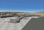
| El Paso ELP / KELP |
|
Images related to this file:
File Description:

This is a complete rebuild of El Paso Int'l Airport. The passenger terminals have been replaced with custom buildings, and the cargo ramp has been enhanced as well. This scenery has a very detailed landside and parking lot with lots of static parked cars which can be very frame-rate intensive. There is an optional file that adds more cars for faster systems. All cars can be removed for slower systems as well. The AFCAD file was built from the default version with AFX. This scenery was built using Abacus'EZ-Scenery program.
| Filename: | El_Paso_ELP__KELP.zip |
| License: | Freeware |
| Added: | 5th September 2010, 11:10:12 |
| Downloads: | 2,113 |
| Author: | William Morgan, FRFStudio.net |
| Size: | 15.51 MB |
| Category: Flight Simulator 2004 - Scenery | |
| St Brieuc Wind Farm |
|
File Description:
A recently commissioned 62-turbine windfarm in the Bay of St. Malo.
Written for FS9, using SceneGenX, from data published by the contractors on the internet.
As usual, do what you want with it except charge for it 😉
Enjoy!
| Filename: | St_Brieuc_Wind_Farm.zip |
| License: | Freeware |
| Added: | 31st March 2024, 17:15:14 |
| Downloads: | 62 |
| Author: | Chris Eve |
| Size: | 1.5 KB |
| Category: Flight Simulator 2004 - Scenery | |
| Airstrips of South-West France |
|
File Description:
Part two of my "Airstrips of Western Europe" project, these 90+ sceneries are mostly default basic airstrips from FS2004, enhanced with taxiways, parking spaces and aprons as appropriate, to facilitate the activation of lightweight GA AI traffic, primarily over the south-west of France. Hopefully these will allow a degree of continuity between my previous upload (Airstrips of North-West Europe) and the existing freeware releases for Spain and Portugal.
Again, there's no photo-realism here, just a selection of basic 'generic' buildings, more or less accurately sized and placed to reflect the airfield layout as seen on on-line satellite imagery and aerial photography. These buildings have minimal effect on frame-rates, so are ideal for this kind of job. The airfields are aligned as well as possible with the roads etc. in UT Europe and the Genesis Europe mesh, but should mostly be fine in a default installation or other configuration.
A good number of airfields in this area have been neatly implemented in the "Occitania_VFR" package, so I've not duplicated their work.
Also included are some "bonus" sceneries from further north that weren't included in my previous upload. Just copy them over as appropriate if required.
| Filename: | Airstrips_of_SouthWest_France.zip |
| License: | Freeware |
| Added: | 16th July 2024, 18:20:44 |
| Downloads: | 112 |
| Author: | Chris Eve |
| Size: | 274.73 KB |
| Category: Flight Simulator 2004 - Scenery | |
| SBKP_2021_V3-- SBKP-VCP Viracopos Campinas Int'l |
|
Images related to this file:
File Description:
FS2004 NEW VERSION SBKP_2021_V3-- SBKP-VCP Viracopos Campinas Int'l (sometimes referred to as São Paulo/Campinas or São Paulo/Viracopos)
V3 (20210704) Full V2 +
- towers homemade (with Sketchup)
- Commercial Center homemade (with Sketchup)
- Azul hangar homemade (with Sketchup)
- some busses and trucks (not in good position)
V2
- New terminals (with night textures) are no longer generic buildings but homemade (with Sketchup)
- New blue & green taxiways lights (with AFLT)
- In order to lighten the scene, all non-generic vehicles in the SBKP_2020 scene have been removed.
- This scenery was built from the official maps for the runway and taxiways with GoogleMaps as a background image and Jeppesen charts as support.
- The different signs were positioned without any documentation or references.
- all taxiways, aprons are built Without ADE Taxiway Possibililties (now reason AI possible with SBKP_ADE9_HGS.bgl)
| Filename: | SBKP_2021_V3_SBKPVCP_Viracopos_Campinas_Intl.zip |
| License: | Freeware |
| Added: | 4th July 2021, 05:46:10 |
| Downloads: | 991 |
| Author: | Serge Libon |
| Size: | 63.55 MB |
| Category: Flight Simulator 2004 - Scenery | |
| Nanjing Dajiaochang Z08T - Chinese Airports From Yesteryear No.1 |
|
Images related to this file:
File Description:

Built with ADE with satellite aligning. Reqiures EZ scenery library: https://www.flightsim.com/files/file/143843-fs2004-ez-scenery-librarys-exe/.
This is the first airport in this series, focusing on old airports in China that now only lives in memory. Nanjing Dajiaochang Airport (NKG/Z08T) was an airport that served Nanjing, the capital of East China's Jiangsu province. It is located 6.2 kilometres (3.9 mi) south of Xinjiekou, the center of Nanjing, and is surrounded on three sides by the Qinhuai River. Opened in 1934, it was an important Chinese airbase during WWII. Civil aviation moved to the new Lukou International Airport in 1997, and then the airforce moved out in 2015 when Dajiaochang finally closed.
| Filename: | Nanjing_Dajiaochang_Z08T__Chinese_Airports_From_Ye.zip |
| License: | Freeware |
| Added: | 23rd July 2024, 00:59:47 |
| Downloads: | 46 |
| Author: | Yue Pan |
| Size: | 101.1 KB |
© 2001-2026 AVSIM Online
All Rights Reserved
Privacy Policy |