
Where Flight Simulation Enthusiasts Gather from Around the World!
AVSIM Library - Search Results

| Category: Flight Simulator 2004 - Scenery | |
| Buttonville Municipal Airport |

|
File Description:
Canada's 10th most active airport strategically located in the heart of the GTA, this highly-accessible airport serves as a vital economic link to the region welcoming corporate visitors, tourists, aviation students and pilots from around the globe. Compatible with Ultimate Terrain and Flight Ontario's The Greater Toronto Area UT.
| Filename: | Buttonville_Municipal_Airport.zip |
| License: | Freeware |
| Added: | 23rd December 2005, 12:48:38 |
| Downloads: | 7,462 |
| Author: | Jim Kanold - Flight Ontario |
| Size: | 12.93 MB |
| Category: Flight Simulator 2004 - Scenery | |
| SKAP COLOMBIA afcad |
|
File Description:
COLOMBIA NOTAM : Hello from Greece. Recently I downloaded the colapts1.zip , colapts3.zip , colapts4.zip from Avsim. I installed them and
then found an error at SKAP airport (colapts4.zip). The RWY was above the surface. I contacted with the creator (Detlev Rohmer) who was very kind and
mentioned he had the same problem at SKAP but he could not fix it. Finally after some time enough I managed to solve it
with Afcad and with help from Tips and Tricks by David “Opa†Marshall. File afcadtrt.zip from Flightsim.com "Using Afcad
taxiways as an alternative way to flatten an area." Now the SKAP is ok.
| Filename: | SKAP_COLOMBIA_afcad.zip |
| License: | Freeware |
| Added: | 2nd November 2023, 10:55:32 |
| Downloads: | 46 |
| Author: | JOHN .S |
| Size: | 3.6 KB |
| Category: Flight Simulator 2004 - Scenery | |
| Colombia Thermals and FAC Glider |
|
File Description:
A set of thermals that include the complete Colombian Andean
and coastal territories and the islands of San Andres and Providencia.
Also a Grob G-102 Astir CS glider by Max Roodveldt repainted with the
Fuerza Aerea Colombiana colors.
| Filename: | Colombia_Thermals_and_FAC_Glider.zip |
| License: | Freeware |
| Added: | 30th August 2005, 13:09:28 |
| Downloads: | 1,113 |
| Author: | Alejandro Villa |
| Size: | 5.3 MB |
| Category: Flight Simulator 2004 - Scenery | |
| Riga Airport - EVRA - Latvia |
|
File Description:
This scenery represents the main international gateway airport to Latvia. Riga is the home of airBaltic, RAF-Avia, Inversija, Lat Charter, Latpass, and is becoming involved in the low-cost destinations boom, with services by Ryanair already established and new services by Aer Lingus. The airport is also in talks with Easyjet regarding the possibility of services. For longer-haul, Uzbekistan stages a 767 through here to New York, and Israir operates a weekly 757 service to Tel Aviv. If you fancy flying an An-72 or IL-76 in FS9, you now have an airport to go with it. Gate numbers at the pier are accurate, gate numbering elsewhere is guesstimated; the airport has full night lighting. As with my Sharjah scenery (just receiving a minor upgrade) I have included a fair amount of off-airport detail. Please enjoy your stay in Latvia!
| Filename: | Riga_Airport__EVRA__Latvia.zip |
| License: | Freeware, limited distribution |
| Added: | 12th August 2005, 19:40:41 |
| Downloads: | 14,606 |
| Author: | Matthew Ministry |
| Size: | 1.65 MB |
| Category: Flight Simulator 2004 - Scenery | |
| PABR - Barrow - Alaska, USA |
|
Images related to this file:
File Description:
The town of Barrow is in the far north of Alaska, and is best known in flying circles as the place where Wiley Post crashed his floatplane on takeoff and killed himself and Will Rogers. The crash was some 15 miles south of Barrow and was "assisted" by the mismatched fuselage, wings, and floats that had been assembled to create the floatplane. The Barrow population is largely Inupiat and totals some 4,400. The downtown area of Barrow is immediately north of the airport. The second and largest part of Barrow is further north past a string of lagoons and is locally called Browerville. To the northeast along the coast is the smallest part around what used to be the Naval Arctic Research Lab, and is now a college. To the east of this are the DEW buildings, plus two large navy hangars and the gravel runway that was used to serve the DEW station. The PABR runway is aligned 06-24 in FS9 and is 7,100 feet long and 150 feet wide, built on top of a gravel base and surround that copes with the underlying permafrost. There is PAPI at both ends and an ILS and approach lights on 06; 06 circuits are to the right. The airport notes include a warning that the apron is not a standard width and that large planes that are enroute to the far end of the runway will not be able to taxi past a plane parked at the gate and should use the runway as a taxiway, then turn and takeoff. FS9 AI cannot cope with that, so the apron here is wider. There are, in real life and the AI, daily flights by Air Alaska (three at least) and Era (several, and which is now called Ravn, hence the new hangar door motif) and air cargo flights by Northern Air Cargo and Everts, plus GA. The buildings have been made with photographic textures or textures made from reference photos. I decided that while 500+ scenery objects was probably ok for most people the required 900+ to "make" the town of Barrow would likely not be. The auto-generated FS9 town objects could not be left as Barrow with trees would not look at all like reality; I have "faded" the density of the town buildings into the distance from the airport.
| Filename: | PABR__Barrow__Alaska_USA.zip |
| License: | Freeware, limited distribution |
| Added: | 17th May 2016, 09:32:36 |
| Downloads: | 971 |
| Author: | Roger Wensley |
| Size: | 15.12 MB |
| Category: Flight Simulator 2004 - Scenery | |
| Perrine Bridge, Twin Falls Idaho Updated |
|
Images related to this file:
File Description:
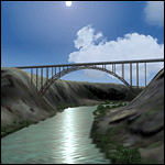
A prominent VFR landmark near Twin Falls Idaho, the Perrine Bridge spans over 1600' and stands 486 feet above the river below. At one time it was the tallest bridge in the world. Perrine Bridge is the only man-made structure in the USA were "base jumping" is allowed without a permit 365 days out of the year. Download includes gmax bridge object, a small photoscenery for the surrounding area, and two saved flight scenarios for exploring the scenery in the default J3 Cub. Bridge surface is landable and crash box has been removed allowing flight beneath the bridge. Scenery is compatible with, and nicely compliments John B. Loney's "Joslin-Magic Valley Regl" airport scenery (ktwf_v1.zip). Requires Ultimate Terrain and freeware mesh product, links provided in the readme.
| Filename: | Perrine_Bridge_Twin_Falls_Idaho_Updated.zip |
| License: | Freeware, limited distribution |
| Added: | 5th July 2011, 04:28:11 |
| Downloads: | 410 |
| Author: | Jim Robinson |
| Size: | 1.52 MB |
| Category: Flight Simulator 2004 - Scenery | |
| Pontchartrain Bridge Replacement Update |
|
File Description:
Hardens the bridge deck on the Pontchartrain Bridge Replacement file.
| Filename: | Pontchartrain_Bridge_Replacement_Update.zip |
| License: | Freeware |
| Added: | 30th April 2008, 20:25:41 |
| Downloads: | 452 |
| Author: | Guy Maricich |
| Size: | 1.65 KB |
| Category: Flight Simulator 2004 - Scenery | |
| Confederation Bridge |
|
File Description:
A depiction of the Bridge which spans between New Brunswick and Prince Edward Island
| Filename: | Confederation_Bridge.zip |
| License: | Freeware, limited distribution |
| Added: | 28th September 2003, 13:19:59 |
| Downloads: | 1,826 |
| Author: | Garvin Barnicoat |
| Size: | 21.91 KB |
| Category: Flight Simulator 2004 - Scenery | |
| Margarita Air Club |
|
File Description:
This is a totally new scenery file for the Margarita Air Club designed with FSSC for FS9. Utilizes Garrish Grays tree textures and totally replaces the TMAC2.zip file designed for FS2002. This file works equally well in 2002 and 2004. The town of Margaritaville is also modelled in this file. Enjoy!
| Filename: | Margarita_Air_Club.zip |
| License: | Freeware |
| Added: | 2nd September 2003, 02:24:21 |
| Downloads: | 2,184 |
| Author: | Todd Lucas |
| Size: | 4.29 MB |
| Category: Flight Simulator 2004 - Scenery | |
| Jerusalem |
|
File Description:
FS2004 Scenery - Jerusalem. The third part of Israel
scenery covering the mountain range of Samaria, Judea
and the cities of Jerusalem and Bethlehem. The scenery
is made in the highest detail with new terrain textures
and it shows all main roads, secondary roads, junctions,
rail roads, vegetation and residential areas with a
population of 1,000 and above. The scenery is enhanced
with over 300 structures and buildings made in Gmax.
Among them the Old City of Jerusalem with its walls and
gates, Mount Temple, the Wailling Wall, the city Citadel,
the Holy Sepulchre and all other major churches and
monasteries of Jerusalem, including the Church of
Nativity in Bethlehem and the churches on Mount Olive
and Mount Zion. The scenery also covers in high detail
the New City of Jerusalem, with all landmark structures
and buildings such as the Knesset (Israel's parliament),
museums, the Supreme Court, Yad-Vashem (the holocaust
memorial), Hadasa hospital, Teddi soccer stadium, all
hotels and highrise buildings and much more. There are
also landmarks outside Jerusalem such as the Latrun
Trappist monastery and the nearby Armor Corps Memorial.
All major structures are based on real measurements and
photos taken from the ground. The textures are all
specially made for this scenery. The scenery is enhanced
with night lighting to enable easy VFR navigation by
night.
| Filename: | Jerusalem.zip |
| License: | Freeware |
| Added: | 15th April 2004, 15:39:12 |
| Downloads: | 20,043 |
| Author: | Seev Kahn |
| Size: | 4.49 MB |
© 2001-2026 AVSIM Online
All Rights Reserved
Privacy Policy |