
Where Flight Simulation Enthusiasts Gather from Around the World!
AVSIM Library - Search Results

| Category: Flight Simulator 2004 - Scenery | |
| Rabah Bitat Airport (DAAB) Algeria - Scenery |

|
File Description:
Formerly known as Les Salines Airport, and popularly as El Mellah Airport is an international airport located 9 km south of Annaba, a city in Algeria. It is named after Rabah Bitat a president of Algeria (1978-1979). During World
War II the airport was known as Bone Airfield, and was used by the German Luftwaffe. Later captured by the United States Army, the USAAF Twelfth Air Force in the Western Desert Campaign in 1942-1943.
| Filename: | Rabah_Bitat_Airport_DAAB_Algeria__Scenery.zip |
| License: | Freeware |
| Added: | 7th July 2010, 14:55:28 |
| Downloads: | 1,968 |
| Author: | Emad Qtiefan |
| Size: | 5.58 MB |
| Category: Flight Simulator 2004 - Scenery | |
| Mega Airport Memmingen (EDJA/FMM), Germany |
|
Images related to this file:
File Description:
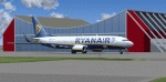
Memmingen Airport (EDJA) is located 100km West of Munich in Southern Germany. Several airlines operate out of the airport including Ryanair, Hapag-Lloyd Express, and Air Berlin. It's a small public airport. One of 4 airports in Bavaria with commercial air service and it has the highest elevation of all of Germany's commercial airports. Prior to 2008-09-25, it was known as Allgäu Airport/Memmingen. The airport not only serves Memmingen and the Allgäu area but also provides a low-cost alternative to Munich Airport.
This scenery is developed for FS2004 and updates the airport with new buildings and textures, along with the correct runway and taxiway dimensions and lighting.
| Filename: | Mega_Airport_Memmingen_EDJAFMM_Germany.zip |
| License: | Freeware, limited distribution |
| Added: | 7th July 2010, 23:19:27 |
| Downloads: | 6,254 |
| Author: | Ben Elsen |
| Size: | 9.49 MB |
| Category: Flight Simulator 2004 - Scenery | |
| KOLF - Wolf Point, Montana, USA - version 2 |
|
Images related to this file:
File Description:
This is version 2 of my KOLF scenery. Version 1 was missing the correct AFCAD, a hanger and a texture file.
| Filename: | KOLF__Wolf_Point_Montana_USA__version_2.zip |
| License: | Freeware |
| Added: | 11th July 2010, 17:34:49 |
| Downloads: | 441 |
| Author: | Eric Cagan |
| Size: | 1.44 MB |
| Category: Flight Simulator 2004 - Scenery | |
| Custer Airport, KTTF, Monroe, MI |
|
Images related to this file:
File Description:
FS2004 Scenery - Custer Airport (ICAO: KTTF, FAA LID: TTF), sometimes referred to as Monroe Custer Airport, is a city-owned public airport located in the city of Monroe in Monroe County, Michigan. The airport opened in November 1946 and was named for George Armstrong Custer, who spent much of his early life in Monroe. Custer Airport is able to accommodate a large variety of aircraft, including single engine aircraft, twin engine aircraft, and business jets such as the Cessna Citation and Learjet. The airport has personal hangars that house approximately 45 airplanes and a large hangar that houses several corporate aircraft as well as the Monroe Aviation School of Flight and Monroe Aviation Aircraft Maintenance. Created using Instant Scenery 2. AI Aircraft included. By John B. Loney, Jr.
| Filename: | Custer_Airport_KTTF_Monroe_MI.zip |
| License: | Freeware, limited distribution |
| Added: | 13th July 2010, 02:50:52 |
| Downloads: | 453 |
| Author: | John B. Loney, Jr. |
| Size: | 5.6 MB |
| Category: Flight Simulator 2004 - Scenery | |
| NZMJ Martins Bay, New Zealand |
|
Images related to this file:
File Description:
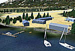
Fiordland, New Zealand. 19nm from Milford Sound. You must have Christian Stock's NZ mesh in the form of "Mountains of New Zealand"
and topo in the form of "Lakes and Rivers of New Zealand".
| Filename: | NZMJ_Martins_Bay_New_Zealand.zip |
| License: | Freeware |
| Added: | 13th July 2010, 09:19:02 |
| Downloads: | 359 |
| Author: | Godfrey Tier |
| Size: | 855.99 KB |
| Category: Flight Simulator 2004 - Scenery | |
| Campbell River floats CAE3 UPDATE |
|
Images related to this file:
File Description:
This update deals with terrain variations that may be caused by an add-on mesh such as the Genesis one that I installed, and which I discovered made small hills that disrupted the fencing and car parks. This flatten will deal with this or a similar problem. If you aren't having a problem then you don't need this.
| Filename: | Campbell_River_floats_CAE3_UPDATE.zip |
| License: | Freeware, limited distribution |
| Added: | 15th July 2010, 01:58:09 |
| Downloads: | 414 |
| Author: | Roger Wensley |
| Size: | 572.44 KB |
| Category: Flight Simulator 2004 - Scenery | |
| Rockcliffe Flying Club update for the Flight Ontario Rockcliffe CYRO scenery in Ontario, Canada |
|
Images related to this file:
File Description:
I recently installed a new mesh and discovered that some of my sceneries needed some modifications; CYRO Rockcliffe is one of them. Some of you may have the same problem at the east end of the airfield. This version takes care of changes that any add-on mesh may make by getting the land flat where it needs to be for the fences, the access road on the edge of the flat where it is in real life, and makes the best that can be made of the yacht club access ramp (unfortunately it is very difficult to manage elevation changes within FS9). Even if you have the default FS9 mesh this should still work ok. As I was anyway posting this I added night textures for the new clubhouse.
| Filename: | Rockcliffe_Flying_Club_update_for_the_Flight_Ontar.zip |
| License: | Freeware, limited distribution |
| Added: | 16th July 2010, 00:32:22 |
| Downloads: | 329 |
| Author: | Roger Wensley |
| Size: | 842.78 KB |
| Category: Flight Simulator 2004 - Scenery | |
| Marine One at The White House |
|
Images related to this file:
File Description:
Marine One at The White House. This small scenery package places the Marine One Helicopter at The White House and optionally at Andrews Air Force Base - waiting to transport the President. Setups are included for the default FS2004 scenery and for those using the MAIW enhancement of Andrews AFB. All files are included. Helicopter model by D.Hardcastle with textures by Christopher Baird and Dallas Mullen.
The Marine One Helicopter is an "almost static" display. See instructions for further details regarding this procedure. Please unzip to a temporary folder and follow the installation instructions. Compiled for your flying enjoyment by David "Opa" Marshall.
| Filename: | Marine_One_at_The_White_House.zip |
| License: | Freeware |
| Added: | 18th July 2010, 19:01:23 |
| Downloads: | 563 |
| Author: | David "Opa" Marshall |
| Size: | 1.41 MB |
| Category: Flight Simulator 2004 - Scenery | |
| KELM - Elmira Corning Regional |
|
Images related to this file:
File Description:
FS2004 Scenery-Elmira/corning Regional Airport serves Elmira and Chemung County and is owned by the County Of Chemung. The airport has more than one runway. The longest is a paved runway extending 7000 feet. The facility is at an elevation of 955 feet at a distance of about 6 miles from Elmira. This scenery has dynamic vehicles and humans, so watch out for ground traffic and pedestrians. Lago's FES is a must for the dynamic scenery. Also created with Rwy12 and FSDS2. Requires Nova, NovaGold, NovaSim and ASDv2.1 textures. AFCAD2 and Traffic Tools files included. By John B. Loney, Jr.
| Filename: | KELM__Elmira_Corning_Regional.zip |
| License: | Freeware, limited distribution |
| Added: | 17th May 2010, 22:03:14 |
| Downloads: | 1,169 |
| Author: | John B. Loney, Jr. |
| Size: | 928.37 KB |
| Category: Flight Simulator 2004 - Scenery | |
| Princeton 2005 |
|
Images related to this file:
File Description:
FS2004 Scenery-A completely reworked Princeton Airport with FSDS2, Rwy12 and Lago's FSE. Princeton Airport(39N) serves Princeton/Rocky Hill and Somerset County NJ and is owned by Princeton Aero Corp. The paved runway extends for 3099 feet. The facility is at an elevation of 125 feet at a distance of about 3 miles from Princeton/Rocky Hill/. Requires AFCAD2, Traffic Tools v2.0, and Nova and Nova Gold textures. Rwy12 and FSE recommended for full effect. By John B. Loney, Jr
| Filename: | Princeton_2005.zip |
| License: | Freeware, limited distribution |
| Added: | 17th May 2010, 22:04:49 |
| Downloads: | 902 |
| Author: | John B. Loney, Jr. |
| Size: | 1.38 MB |


© 2001-2026 AVSIM Online
All Rights Reserved
Privacy Policy |