
Where Flight Simulation Enthusiasts Gather from Around the World!
AVSIM Library - Search Results

| Category: Flight Simulator 2004 - Scenery | |
| ISD Linate Airport 2013 (LIML) update for the Airport Area |

|
Images related to this file:
File Description:

The scenery ISD LIML nearest airport building 2013, is essentially an update of the area near the airport Forlanini Milan in particular the town of Mezzate, San Donato Milanese, Linate and suoth quartier of the Milan City.
Is just an a better views in particular in approach.
The objects that were created by Gianlucag Thank you, photoreal scenery is that of Isd with Mr. Mandelli
With the file in question can have an update of the beautiful scenery LIML 2004.
I suggest to download and install in your fs 2004, Liml 2004 whit his update.
After downloading, install as a normal scenery.
best regards
fabio ferrari ([email protected])
| Filename: | ISD_Linate_Airport_2013_LIML_update_for_the_Airpor.zip |
| License: | Freeware, limited distribution |
| Added: | 22nd January 2013, 01:54:57 |
| Downloads: | 4,565 |
| Author: | Fabio Ferrari |
| Size: | 81.94 MB |
| Category: Flight Simulator 2004 - Scenery | |
| Upgrade LIML-ISD |
|
File Description:
This file is an upgrade of the BGL file for the Milano Linate scenery (LIML) created by ISD Projects. We have updated the ILS frequency, added a new DME and made other changes. You can read the "readme.txt" to see all the changes.
| Filename: | Upgrade_LIMLISD.zip |
| License: | Freeware |
| Added: | 13th September 2008, 17:06:15 |
| Downloads: | 8,673 |
| Author: | Gian Marco Gallo and Andrea Rossi |
| Size: | 5.46 KB |
| Category: Flight Simulator 2004 - Scenery | |
| Anguilla, The Valley, Lloyd Intl |
|
File Description:
Anguilla, The Valley, Lloyd Intl airport
| Filename: | Anguilla_The_Valley_Lloyd_Intl.zip |
| License: | Freeware, limited distribution |
| Added: | 22nd March 2020, 19:09:58 |
| Downloads: | 84 |
| Author: | Florin Coter |
| Size: | 3.35 KB |
| Category: Flight Simulator 2004 - Scenery | |
| Project Mexico Real LOD10 File 8 of 11 |
|
Images related to this file:
File Description:
File 8th of 11 of a Terrain Mesh that covers the entirety of Mexican Territory and related bordering U.S., Guatemala and Belice areas, part of the "Proyecto M�©xico Real" project, compiled at LOD10 (1.24 arcseconds in latitude and 1.65 arcseconds in longitude) resolution from INEGI data. Intended to enhance the virtual flying experience complementing the LOD8 and LOD9 versions compiled from the same data. Compatible backwards with Flight Simulator 2000, Flight Simulator 2002 and Combat Flight Simulator 2. Refer to the file contents about the cover area to this compressed file. (Re-upload due to AVSIM hack)
| Filename: | Project_Mexico_Real_LOD10_File_8_of_11.zip |
| License: | Check within download |
| Added: | 29th August 2010, 04:15:59 |
| Downloads: | 1,172 |
| Author: | Juan Jose Galvan Bautista |
| Size: | 73.7 MB |
| Category: Flight Simulator 2004 - Scenery | |
| Project Mexico Real LOD10 File 5 of 11 |
|
Images related to this file:
File Description:
Re-upload. File 5th of 11 of a Terrain Mesh that covers the entire Mexican Territory and related areas bordering the U.S., Guatemala and Belize areas. Part of the "Proyecto M�©xico Real" project, compiled at LOD10 (1.24 arcseconds in latitude and 1.65 arcseconds in longitude) resolution from INEGI data. Intended to enhance the virtual flying experience complementing the LOD8 and LOD9 versions compiled from the same data. Compatible backwards with Flight Simulator 2000, Flight Simulator 2002 and Combat Flight Simulator 2. Refer to the file contents about the cover area to this compressed file.
| Filename: | Project_Mexico_Real_LOD10_File_5_of_11.zip |
| License: | Check within download |
| Added: | 7th August 2010, 22:08:10 |
| Downloads: | 3,015 |
| Author: | Juan Jose Galvan Bautista |
| Size: | 73.08 MB |
| Category: Flight Simulator 2004 - Scenery | |
| Project Mexico Real LOD10 File 7 of 11 |
|
Images related to this file:
File Description:
File 7th of 11 of a Terrain Mesh that covers the entirety of Mexican Territory and related bordering U.S., Guatemala and Belice areas, part of the "Proyecto Mexico Real" project, compiled at LOD10 (1.24 arcseconds in latitude and 1.65 arcseconds in longitude) resolution from INEGI data. Intended to enhance the virtual flying experience complementing the LOD8 and LOD9 versions compiled from the same data. Compatible backwards with Flight Simulator 2000, Flight Simulator 2002 and Combat Flight Simulator 2. Refer to the file contents about the cover area to this compressed file. (Re-upload due to AVSIM hack)
| Filename: | Project_Mexico_Real_LOD10_File_7_of_11.zip |
| License: | Check within download |
| Added: | 23rd August 2010, 00:40:35 |
| Downloads: | 2,864 |
| Author: | Juan Jose Galvan Bautista |
| Size: | 74.25 MB |
| Category: Flight Simulator 2004 - Scenery | |
| Project Mexico Real LOD10 File 10 of 11 |
|
Images related to this file:
File Description:
Re-upload. File 10th of 11 of a Terrain Mesh that covers the entirety of Mexican Territory and related bordering U.S., Guatemala and Belice areas, part of the "Proyecto Mexico Real" project, compiled at LOD10 (1.24 arcseconds in latitude and 1.65 arcseconds in longitude) resolution from INEGI data. Intended to enhance the virtual flying experience complementing the LOD8 and LOD9 versions compiled from the same data. Compatible backwards with Flight Simulator 2000, Flight Simulator 2002 and Combat Flight Simulator 2. Refer to the file contents about the cover area to this compressed file.
| Filename: | Project_Mexico_Real_LOD10_File_10_of_11.zip |
| License: | Check within download |
| Added: | 5th September 2010, 20:55:05 |
| Downloads: | 3,060 |
| Author: | Juan Jose Galvan Bautista |
| Size: | 70.54 MB |
| Category: Flight Simulator 2004 - Scenery | |
| Georgian Bay Airfields CYEM & CNR4 in Ontario, Canada |
|
Images related to this file:
File Description:
These are two airfields in Ontario around Georgian Bay, which is off the east side of Lake Huron in the Great Lakes. Manitoulin East Muni CYEM is at the northern end of the Bay in an area of coves and lakes, on what is actually an island that is almost but not quite connected to the mainland in several places. There is no immediately adjacent town and the field serves the county area. The runway is 3,500 feet of asphalt aligned 02-20 with PAPI at both ends. The second airfield is Tobermory CNR4, which is just south of the small town and ferry terminal of the same name on the northern end of the peninsula that forms Georgian Bay. The runway is 3,180 feet long and aligned 12-30; there is no longer a 450 feet displacement to the 30 threshold.
| Filename: | Georgian_Bay_Airfields_CYEM__CNR4_in_Ontario_Canad.zip |
| License: | Freeware, limited distribution |
| Added: | 12th August 2018, 19:31:18 |
| Downloads: | 138 |
| Author: | Roger Wensley |
| Size: | 17.45 MB |
| Category: Flight Simulator 2004 - Scenery | |
| NZGC - Charlton Aerodrome, Gore, New Zealand |
|
Images related to this file:
File Description:
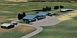
Charlton Aerodrome, Gore, New Zealand.
You need Christian Stock's NZ mesh in the form of "Mountains of New Zealand"
and topo in the form of "Lakes and Rivers of New Zealand".
| Filename: | NZGC__Charlton_Aerodrome_Gore_New_Zealand.zip |
| License: | Freeware |
| Added: | 1st July 2010, 14:32:34 |
| Downloads: | 226 |
| Author: | Godfrey Tier |
| Size: | 671.32 KB |
| Category: Flight Simulator 2004 - Scenery | |
| Alps LOD10 Topo Mesh - Switzerland and France |
|
Images related to this file:
File Description:
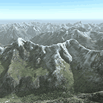
Yet another terrain mesh package of the European Alps? Well, this one is different in that it is NOT primarily based on the Shuttle Radar (SRTM) data with their incomplete coverage of prominent peaks and ridges. Instead, most of the source data for this project were developed over many months by Jonathan de Ferranti using detailed topographic maps. While Jonathan's work is unrelated to flight simulation he kindly gave me permission to compile his data for use in FS. The result is a wonderful improvement in detail and accuracy over any existing SRTM- or DTED-based mesh file, freeware or commercial (a link to an extensive set of screenshot comparisons is included in the read-me file).
I've compiled the source data at LOD10 (38-m) grid resolution because the coverage area is smaller than most existing mesh files. Thus, anyone can use these files without having to first uninstall their current mesh set. Also included are LOD9 and LO8 buffer mesh files. Note: if you own Switzerland Professional with its high-resolution terrain mesh then you don't need this package, at least not the Switzerland files!
| Filename: | Alps_LOD10_Topo_Mesh__Switzerland_and_France.zip |
| License: | Freeware, limited distribution |
| Added: | 30th May 2010, 09:51:03 |
| Downloads: | 58,986 |
| Author: | Holger Sandmann, Jonathan de Ferranti |
| Size: | 50.03 MB |
© 2001-2026 AVSIM Online
All Rights Reserved
Privacy Policy |