
Where Flight Simulation Enthusiasts Gather from Around the World!
AVSIM Library - Search Results

| Category: Flight Simulator 2004 - Scenery | |
| Buffalo Niagara Int'l airport (KBUF) scenery |

|
Images related to this file:
File Description:
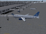
Re-upload. Buffalo Niagara Int'l airport scenery. Includes a new custom afcad2 file with the changes to runway 14/32. Scenery enhancements made to the cargo, general aviation, and terminal areas including jetways. My goal was to enhance the airport while still keeping framerates high.
| Filename: | Buffalo_Niagara_Intl_airport_KBUF_scenery.zip |
| License: | Freeware, limited distribution |
| Added: | 13th May 2010, 03:18:02 |
| Downloads: | 4,076 |
| Author: | Craig Swartzlander |
| Size: | 251.87 KB |
| Category: Flight Simulator 2004 - Scenery | |
| Working TACAN Beacons in the UK |
|
Images related to this file:
File Description:

Working TACAN Beacons in the UK: In real-life TACAN beacons require a TACAN receiver to receive the course (OBS) information of the beacon. With a civil VOR/DME receiver you only receive the distance (DME) to the beacon. The problem in FS is that there are no dedicated TACAN gauges, so it's not possible to perform TACAN approaches, because this requires course information of the beacon. To overcome this problem i've modified the TACAN beacons in the UK so you can fully use them with civil receivers. And so are able to fly TACAN approaches. For charts how to fly the TACAN approaches see (procedure section) http://www.cenor.org/ (reupload) by Marcel Ritzema
| Filename: | Working_TACAN_Beacons_in_the_UK.zip |
| License: | Freeware, limited distribution |
| Added: | 13th May 2010, 21:06:04 |
| Downloads: | 1,020 |
| Author: | Marcel Ritzema |
| Size: | 492.34 KB |
| Category: Flight Simulator 2004 - Scenery | |
| Nordhorn & Siegenburg Air to Ground Ranges |
|
Images related to this file:
File Description:
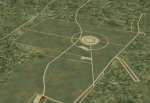
Scenery for the German air to ground ranges ED-R37 Nordhorn (ETUN) and ED-R138 Siegenburg (ETAV). Both are used by NATO air forces to practice ground attacks. Nordhorn located close to Hopsten AB in Nordrhein-Westfalen. Siegenburg is located near Ingolstadt/Manching AB in Bayern. Version 2.1 contains updates for both ranges and more accurate target information. By Marcel Ritzema
| Filename: | Nordhorn__Siegenburg_Air_to_Ground_Ranges.zip |
| License: | Freeware, limited distribution |
| Added: | 13th May 2010, 21:06:28 |
| Downloads: | 1,195 |
| Author: | Marcel Ritzema |
| Size: | 2.08 MB |
| Category: Flight Simulator 2004 - Scenery | |
| City Federal Building, Birmingham, Alabama |
|
File Description:
Re-upload. Adds the City Federal Building, once the South's tallest to Flight Simulator 2004. It works with Ultimate Terrain, my other sceneries, and the Toni Hitulten Birmingham, Alabama scenery.
| Filename: | City_Federal_Building_Birmingham_Alabama.zip |
| License: | Freeware |
| Added: | 13th May 2010, 21:55:28 |
| Downloads: | 959 |
| Author: | Brittany and Argus Sventon |
| Size: | 79.34 KB |
| Category: Flight Simulator 2004 - Scenery | |
| Factory Field CF40 in Quebec Canada |
|
Images related to this file:
File Description:
Factory Field (my name for it) is in Quebec on highway 321 a few miles north of St Andre Avellin, and 40 miles ENE of Ottawa. The runway is 3,500 feet long and asphalt and went out of regular use in the early 1990's when the airfield was closed. It was sold in 1995 to a company (ELP) that has built up a factory for manufacturing and fitting snow ploughs and other pneumatically operated equipment to trucks, and who now use the runway for testing their snow ploughs. In between times, as it is not marked closed with an "X", it is also occasionally used by customers who fly in, usually to get the drivers there to take delivery of completed trucks. The surface is good and there are no obstructions but also no markings, though with 3,500 feet of 100 feet wide asphalt there is plenty of space and it doesn't much matter.
| Filename: | Factory_Field_CF40_in_Quebec_Canada.zip |
| License: | Freeware, limited distribution |
| Added: | 13th May 2010, 22:11:41 |
| Downloads: | 347 |
| Author: | Roger Wensley |
| Size: | 1.27 MB |
| Category: Flight Simulator 2004 - Scenery | |
| SSJA Joaçaba, Brazil |
|
Images related to this file:
File Description:
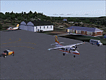
Googly scenery for SSJA Joaçaba - a small domestic airport
in the state of Santa Caterina, Brazil, that is poorly provided for in Flight
Simulator 2004. These scenery files add taxiways, aprons, buildings and other
airport features, so that you and your "AI" traffic can land, taxi, park and
take off in a realistic manner.
The small but prosperous city of Joaçaba was originally established in 1917 as
Cruzeiro and later known as Limeira and Cruzeiro do Sol, but in 1943 adopted
the current name following the introduction of legislation prohibiting cities
in Brazil using the same name - not a bad idea really. Joaçaba has a high
quality medical centre serving the state of Santa Caterina and a renowned
university which both bring traffic to the airport which is served by mainly
by LET410 aircraft of local airline NHT Linhas Aéreas.
The scenery does not purport to be ultra-accurate. Based on high-detail satellite
imagery from Google Earth, the layout is proportionally correct but the added
airport features, such as buildings, are built from default Microsoft objects
and add-on libraries so will not look exactly like the real thing.
[File re-uploaded at request of AVSIM]
| Filename: | SSJA_Joaccedilaba_Brazil.zip |
| License: | Freeware |
| Added: | 14th May 2010, 04:47:22 |
| Downloads: | 1,263 |
| Author: | John Hinson |
| Size: | 65.83 KB |
| Category: Flight Simulator 2004 - Scenery | |
| VEAT Argatala, India |
|
Images related to this file:
File Description:
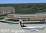
Googly scenery for VEAT Argatala, India - one of the airports that Microsoft seem to have, um, "forgotten" in FS2004. In the real world it is regularly served by Boeings and Airbii of Alliance Air, Indian Airlines, Jet Airways and Kingfisher Airlines (and smaller aircraft), using the 6000 foot runway with little room for manoevre. These scenery files add aprons, taxiways, buildings and other airport features to Flight Simulator's bland representation and allow you, and "AI" traffic, to land, taxi, park and take off realistically. The scenery does not purport to be ultra-accurate. Based on high-detail satellite imagery from Google Earth, the layout is proportianally correct but the added airport features, such as buildings, are built from default Microsoft objects and add-on libraries so will not look like the real thing. You are not obliged to download and install any additional scenery libraries, but to enjoy this scenery in its entirety, you may wish to. It will work fine, with or without. Details of optional additional scenery library downloads are provided within.
[File re-uploaded at request of AVSIM]
| Filename: | VEAT_Argatala_India.zip |
| License: | Freeware |
| Added: | 14th May 2010, 04:49:05 |
| Downloads: | 1,658 |
| Author: | John Hinson |
| Size: | 65.16 KB |
| Category: Flight Simulator 2004 - Scenery | |
| New Caledonia (Landclass and Terrain Mesh) AFCAD and Scenery Fix for file n_caled.zip |
|
File Description:
This is a fix for my New Caledonia Landclass and Terrain Mesh file n_caled.zip The AFCAD and scenery files included will repair the problems of AI Aircraft freezing on runways. Scenery modifications have also been made around many of the airports.
| Filename: | New_Caledonia_Landclass_and_Terrain_Mesh__AFCAD_an.zip |
| License: | Freeware |
| Added: | 14th May 2010, 05:07:26 |
| Downloads: | 567 |
| Author: | Charles Reid |
| Size: | 49.16 KB |
| Category: Flight Simulator 2004 - Scenery | |
| VAKE Kandla/Gandhidham, India |
|
Images related to this file:
File Description:
Googly scenery for VAKE Kandla/Gandhidham - a small domestic airport
in the state of Gujurat, India, for which little other than a runway is
provided in Flight Simulator 2004. These scenery files add taxiways, aprons,
buildings and other airport features, so that you and your "AI" traffic can
land, taxi, park and take off in a realistic manner.
Gandhidham is a small city about 5 miles from the seaport of Kandla, in the
Gulf of Kutch, and was developed in 1950 after the separation of Pakistan and
India left the key port of Karachi in Pakistan. The airport is served by daily
flights using turboprop aircraft of Air Deccan.
The scenery does not purport to be ultra-accurate. Based on high-detail satellite
imagery from Google Earth, the layout is proportionally correct but the added
airport features, such as buildings, are built from default Microsoft objects
and add-on libraries so will not look exactly like the real thing.
You are not obliged to download and install any additional scenery libraries,
but to enjoy this scenery in its entirety, you may wish to. It will work fine,
with or without.
[File re-uploaded at request of AVSIM]
| Filename: | VAKE_KandlaGandhidham_India.zip |
| License: | Freeware |
| Added: | 14th May 2010, 05:11:31 |
| Downloads: | 848 |
| Author: | John Hinson |
| Size: | 67.36 KB |
| Category: Flight Simulator 2004 - Scenery | |
| LTCK - Mus Havaalani Airport, Turkey |
|
Images related to this file:
File Description:
Detailed scenery of Mus Airport (LTCK) in Eastern Turkey.
| Filename: | LTCK__Mus_Havaalani_Airport_Turkey.zip |
| License: | Freeware |
| Added: | 14th May 2010, 09:36:12 |
| Downloads: | 1,363 |
| Author: | Vedat Sencan |
| Size: | 2.27 MB |


© 2001-2026 AVSIM Online
All Rights Reserved
Privacy Policy |