
Where Flight Simulation Enthusiasts Gather from Around the World!
AVSIM Library - Search Results

| Category: Flight Simulator 2004 - Scenery | |
| Buechel ETSB (including texture fix) |

|
Images related to this file:
File Description:
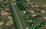
Basic scenery enhancement of Buechel (or Buchel) airbase in Germany. Most 3D objects custom designed. This upload of the scenery includes the texture fix of March 10 2010.
| Filename: | Buechel_ETSB_including_texture_fix.zip |
| License: | Freeware |
| Added: | 10th March 2010, 23:39:34 |
| Downloads: | 1,404 |
| Author: | Nils Lips |
| Size: | 5.35 MB |
| Category: Flight Simulator 2004 - Scenery | |
| EDHF/ETHI Hungriger Wolf |
|
Images related to this file:
File Description:
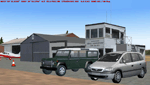
FS2004 Scenery EDHF Hunriger Wolf by Uwe Schweitzer.
EDHF is the new ICAO code of Hungriger Wolf, the former army (helicopter) airbase ETHI in Northern Germany State of Schleswig Holstein. Read the Readme carfully for installation
You need Gerrish Grey's trees_v3.zip
| Filename: | EDHFETHI_Hungriger_Wolf.zip |
| License: | Freeware |
| Added: | 25th May 2010, 19:13:20 |
| Downloads: | 2,377 |
| Author: | Uwe Schweitzer |
| Size: | 7.21 MB |
| Category: Flight Simulator 2004 - Scenery | |
| LYVA Valjevo Airport, Serbia - ALPHA |
|
File Description:
Alpha version of Valjevo LYVA sport airfield, Serbia.
Valjevo (LYVA) is an airport in Serbia, near the city of Valjevo and mountain resort Divcibare. It has one grass runway (direction 08/26) that is 1,250 meters long (4,101 ft) and 50 meters wide. The airport is also known as Divci Airport.
| Filename: | LYVA_Valjevo_Airport_Serbia__ALPHA.zip |
| License: | Freeware |
| Added: | 19th August 2010, 14:29:13 |
| Downloads: | 745 |
| Author: | Nikola Jovanovic |
| Size: | 3.71 MB |
| Category: Flight Simulator 2004 - Scenery | |
| FedEx Scenery for Yakutat, AK |
|
Images related to this file:
File Description:
A small scenery enhancement created with EZ Scenery for Yakutat, AK. Adds a Fed Ex depot to the area. Complete with hangars, buildings, forklifts, etc. Utilizes EZ Scenery objects. EZ Scenery libraries previously installed required.
| Filename: | FedEx_Scenery_for_Yakutat_AK.zip |
| License: | Freeware |
| Added: | 1st June 2010, 09:28:07 |
| Downloads: | 1,211 |
| Author: | Brad Allen |
| Size: | 71.14 KB |
| Category: Flight Simulator 2004 - Scenery | |
| Misty Moorings DynaScene Scenario - 08/18/2005 |
|
File Description:
DynaScene scenario based scenery file for Misty Moorings members and other interested parties. (Misty Fjords Scenery from www.fsaddon.com required). Provides background text, photos, and scenery for a temporary scenario. Story as follows: NEWS FLASH! 08/18/2005 - BUSH PILOT GROUNDED PENDING INVESTIGATION - KETCHIKAN (APX) - The alaska wilderness is no stranger to strange tales. At least that's how it appears in the case of a local bush pilot, Randy Morgan, who had quite a large one to tell.
At 6 PM on the evening of the 16th, Randy and one passenger took off in a Cessna 182RG from Maloney's Tavern on his way back to Ketchikan. "The weather was good and I had no idea what was about to happen" said Randy Morgan. "We had planned our flight to pass over Raptor's Roost and Punchbowl Lake before heading into Ketchikan when I saw it." (full text in download) - Makes use of Rwy12 libraries by Seev Kahn and Glen Gordon (included in download).
| Filename: | Misty_Moorings_DynaScene_Scenario__08182005.zip |
| License: | Freeware |
| Added: | 22nd August 2005, 01:04:19 |
| Downloads: | 968 |
| Author: | Glen Gordon (Professor Khaos) |
| Size: | 4.76 MB |
| Category: Flight Simulator 2004 - Scenery | |
| Lake Grace Airport |
|
File Description:
Lake Grace airport is a small gravel strip 400 kms SE of Perth West Australia Built using Gmax and those two Magic programs Afcad And Rw12 object placer.
| Filename: | Lake_Grace_Airport.zip |
| License: | Freeware |
| Added: | 22nd August 2005, 06:55:15 |
| Downloads: | 638 |
| Author: | Frank Salter |
| Size: | 900.9 KB |
| Category: Flight Simulator 2004 - Scenery | |
| 12VA Hop Along - Clifton Forge, Va |
|
File Description:
Hop Along is located near Clifton Forge, Virginia. Flightsim represents it as in reality,
pretty much what it is, a 2150 foot privately owned grass airstrip. According to airnav.com (a
Great source of information, by the way) 12va is 1060 ft. / 323 m (estimated) above sea level
and about 3 miles SE of CLIFTON FORGE, VA. It also indicates that it is a turf runway that is
"rolling and rough" (somthing that the simulator does not present.) While there are no
published photos of this strip, owned by a Mr Wm E. Boyd, The "Hop Along" I created for this
default enhancement contains a bit of this and a bit of that, to give it a bit of what I hope
is "life" making it a fun place to drop in for a visit.
questions or comments ... [email protected]
| Filename: | 12VA_Hop_Along__Clifton_Forge_Va.zip |
| License: | Freeware |
| Added: | 23rd August 2005, 15:29:56 |
| Downloads: | 966 |
| Author: | Dale Caruso |
| Size: | 477.86 KB |
| Category: Flight Simulator 2004 - Scenery | |
| Telluride Regional Airport v3 ( KTEX ) |
|
File Description:
FS2004 Scenery - Telluride Regional Airport (IATA: TEX, ICAO: KTEX) is a public airport located 5 miles (8 km) west of Telluride, in San Miguel County, Colorado, USA. It is the highest commercial airport in North America, at an elevation of 9,078 feet (2767 m) above sea level. Located on a plateau, the airport's single runway literally dips slightly in the centre. This is version 3. Unlike versions 1 and 2, this scenery had the advantage of Google Earth's satellite image. Created using Instant Scenery by John B. Loney, Jr.
| Filename: | Telluride_Regional_Airport_v3__KTEX_.zip |
| License: | Freeware, limited distribution |
| Added: | 25th March 2008, 15:55:10 |
| Downloads: | 2,801 |
| Author: | John B. Loney, Jr. |
| Size: | 17.23 MB |
| Category: Flight Simulator 2004 - Scenery | |
| RJNN - Nagoya Komaki - Aichi Prefecture, Japan |
|
Images related to this file:
File Description:
This project represents Nagoya Komaki airport in Japan, home of the JASDF KC-767s and C-130s as well as Mitsubishi Aircraft. In the past, Nagoya Komaki was a busy international airport,but now only supports regional airlines and private aircraft on the civilian portion of the airfield. See the readme file for a list of object libraries necessary for this scenery to fully display.
| Filename: | RJNN__Nagoya_Komaki__Aichi_Prefecture_Japan.zip |
| License: | Freeware |
| Added: | 16th October 2015, 15:48:04 |
| Downloads: | 983 |
| Author: | Brent Newman |
| Size: | 31.09 KB |
| Category: Flight Simulator 2004 - Scenery | |
| "Himalayan Peaks" LOD10 Mesh, Volume 8 - Tirich Mir and Pamir |
|
Images related to this file:
File Description:
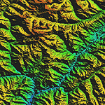
Highly detailed terrain mesh of the Tirich Mir and Pamir areas, N36-39 E71-74. The files in this package are based on Shuttle Radar (SRTM) Version 2 data but with many of the void areas, especially the most significant sections, filled with elevation data generated from topographic maps by Jonathan de Ferranti. While Jonathan's work is unrelated to flight simulation he kindly gave me permission to compile his data for use in FS. The result is a wonderful improvement in detail and accuracy over any existing mesh file, freeware or commercial, based on SRTM or DTED data alone.
Due to the large area of the Himalayas I've compiled the source data as two separate series: the "Himalayan Peaks" series covers prominent mountains and ranges in higher detail and locally overrides any existing LOD9 terrain mesh. In addition, a LOD9 "base mesh" series covering the entire Himalayas will be available for those who do not yet have an add-on terrain mesh of these beautiful mountains.
| Filename: | Himalayan_Peaks_LOD10_Mesh_Volume_8__Tirich_Mir_an.zip |
| License: | Freeware, limited distribution |
| Added: | 29th May 2010, 08:52:47 |
| Downloads: | 9,114 |
| Author: | Holger Sandmann, Jonathan de Ferranti |
| Size: | 47.94 MB |


© 2001-2026 AVSIM Online
All Rights Reserved
Privacy Policy |