
Where Flight Simulation Enthusiasts Gather from Around the World!
AVSIM Library - Search Results

| Category: Flight Simulator 2004 - Scenery | |
| FYOG Oranjemund, Namibia |

|
File Description:
Based on googleEarth. Ez-scenery and rwy12 objects included. Compatible with Holger Sandmann's Namibia LOD9 Terrain mesh (namibia_ne.zip, namibia_nw.zip, namibia_se.zip, namibia_sw.zip, namibia_cp.zip) as well as his namibia_scenery_updates.zip, all found at avsim.com.
| Filename: | FYOG_Oranjemund_Namibia.zip |
| License: | Freeware |
| Added: | 23rd November 2008, 11:53:16 |
| Downloads: | 873 |
| Author: | Detlev J. Rohmer |
| Size: | 3.1 MB |
| Category: Flight Simulator 2004 - Scenery | |
| FYOS Oshakati, Namibia |
|
File Description:
Based on googleEarth. Ez-scenery and rwy12 objects included. Compatible with Holger Sandmann's Namibia LOD9 Terrain mesh (namibia_ne.zip, namibia_nw.zip, namibia_se.zip, namibia_sw.zip, namibia_cp.zip) as well as his namibia_scenery_updates.zip, all found at avsim.com.
| Filename: | FYOS_Oshakati_Namibia.zip |
| License: | Freeware |
| Added: | 29th November 2008, 22:51:33 |
| Downloads: | 778 |
| Author: | Detlev J. Rohmer |
| Size: | 2.06 MB |
| Category: Flight Simulator 2004 - Scenery | |
| FYSM Swakopmund, Namibia for FS9 |
|
File Description:
Based on googleEarth and fotos. Ez-scenery and rwy12 objects included. Compatible with Holger Sandmann's Namibia LOD9 Terrain mesh (namibia_ne.zip, namibia_nw.zip, namibia_se.zip, namibia_sw.zip, namibia_cp.zip) as well as his namibia_scenery_updates.zip, all found at avsim.com.
| Filename: | FYSM_Swakopmund_Namibia_for_FS9.zip |
| License: | Freeware |
| Added: | 12th December 2008, 23:26:45 |
| Downloads: | 1,034 |
| Author: | Detlev J. Rohmer |
| Size: | 10.92 MB |
| Category: Flight Simulator 2004 - Scenery | |
| FYAR Arandis, Namibia |
|
File Description:
Based on googleEarth and fotos. Ez-scenery and rwy12 objects included. Includes the airport, as well as landclass for the town of Arandis and a textured area to represent the uranium mine east-south-east of the airport. Roads in the vicinity have been added and adjusted. Compatible with Holger Sandmann's Namibia LOD9 Terrain mesh (namibia_ne.zip, namibia_nw.zip, namibia_se.zip, namibia_sw.zip, namibia_cp.zip) as well as his namibia_scenery_updates.zip, all found at avsim.com.
| Filename: | FYAR_Arandis_Namibia.zip |
| License: | Freeware |
| Added: | 4th January 2009, 12:17:39 |
| Downloads: | 879 |
| Author: | Detlev J. Rohmer |
| Size: | 7.41 MB |
| Category: Flight Simulator 2004 - Scenery | |
| Walvis Bay International Airport, Namibia (FYWB) |
|
Images related to this file:
File Description:
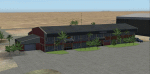
A custom Gmax made Walvis Bay International Airport (FYWB) in Namibia. This representation still has the old terminal building before it was rebuilt into the current structure. The scenery consist of custom made models with photorealistic textures and a photoreal ground that blends nicely with the dessert surroundings. This scenery was around 90% completed when I stopped to wait for the new terminal to be finished, but I have since lost all my source files and as such I am releasing this as is (with the old terminal still in use). The scenery only covers the airport and so the Rooikop Army Base is not included.
| Filename: | Walvis_Bay_International_Airport_Namibia_FYWB.zip |
| License: | Freeware, limited distribution |
| Added: | 9th March 2021, 05:29:38 |
| Downloads: | 218 |
| Author: | Kobus van Wyk |
| Size: | 4.68 MB |
| Category: Flight Simulator 2004 - Scenery | |
| Phoenix, Arizona 30 Meter Terrain Mesh Scenery |
|
File Description:
Mesh Scenery for Microsoft Flight Simulator 2004 and 2002.USGS NED 30 meter (1 arc-second), resampled to LOD10 (38.2 meters). This terrain mesh is centered at Phoenix, Arizona. Coverage area: From about West 111° to West 113° and North 33° to North 34°.
| Filename: | Phoenix_Arizona_30_Meter_Terrain_Mesh_Scenery.zip |
| License: | Freeware |
| Added: | 3rd January 2004, 19:53:36 |
| Downloads: | 3,719 |
| Author: | Phil Cruikshank |
| Size: | 4.66 MB |
| Category: Flight Simulator 2004 - Scenery | |
| Terrain Mesh of Glacier National Park |
|
File Description:
New and updated scenery enhancements for the mountain ranges of southeastern British Columbia and parts of the Alberta Rocky Mountains. They require an existing installation of my files bcmesh9d.zip and/or bcmesh9e.zip. Scenery coverage follows the Trans-Canada Highway from Banff National Park to west of Revelstoke (~350km), with accurate transportation network, rivers and lakes, hydro dams, ski hills, glaciers, and landclass/waterclass updates based on satellite imagery. Also, similar enhancements to the parks and towns of the southern Kootenay, Selkirk, and Monashee mountains. The mesh source data are 0.75-arcsec (~23-m) CDED files, compiled at LOD10 (38-m) resolution. Due to significant changes in FS2004 to vector layering and autogen features, the special scenery enhancements cannot be used with FS2002. However, terrain mesh, new lakes and land/waterclass replacements will work well in FS2002.
| Filename: | Terrain_Mesh_of_Glacier_National_Park.zip |
| License: | Freeware, limited distribution |
| Added: | 18th December 2003, 23:17:35 |
| Downloads: | 8,858 |
| Author: | Holger Sandmann |
| Size: | 12.79 MB |
| Category: Flight Simulator 2004 - Scenery | |
| Southern Ontario Canada LOD 9 Mesh |
|
File Description:
Please note that I forgot to cut the one side of the screenshots so the right side of the image is what was present on my second monitor which in the first two pictures was my background.
The default mesh for Southern Ontario Canada was pretty flat and did not show the small rolling hills that are present throughout the province. This is LOD9 (90 meter) mesh that covers ALL of Southern Ontario from Elliot Lake, Sudbury and North Bay in the North, to near Montreal in the east, to Windsor in the southwest and all points in between. This mesh covers the entire area of Ontario shown in the Toronto VNC.
| Filename: | Southern_Ontario_Canada_LOD_9_Mesh.zip |
| License: | Freeware, limited distribution |
| Added: | 16th January 2004, 02:01:29 |
| Downloads: | 6,544 |
| Author: | David Voogd |
| Size: | 41.32 MB |
| Category: Flight Simulator 2004 - Scenery | |
| Col Visentin Towers - Italy VFR scenery |
|
File Description:
Col Visentin Towers - Italy VFR scenery for Fs9. A lot of telecomunication antennas created with GMAX, location: N46°03'15" E12°16'56". Compatible with P. Mauri Italy Mesh. By Claudio Grassi.
| Filename: | Col_Visentin_Towers__Italy_VFR_scenery.zip |
| License: | Freeware |
| Added: | 2nd March 2004, 13:16:52 |
| Downloads: | 4,356 |
| Author: | Claudio Grassi |
| Size: | 312.28 KB |
| Category: Flight Simulator 2004 - Scenery | |
| Albuquerque Photoreal |
|
File Description:
Photoreal version of Albuquerque, NM including custom mesh, full autogen, custom buildings, AI traffic and AFCAD files for KABQ and KAEG. Based in the Urban Area aerial photos of the city.
| Filename: | Albuquerque_Photoreal.zip |
| License: | Freeware |
| Added: | 26th May 2006, 04:23:37 |
| Downloads: | 5,840 |
| Author: | Kevin Burns |
| Size: | 40.64 MB |


© 2001-2026 AVSIM Online
All Rights Reserved
Privacy Policy |