
Where Flight Simulation Enthusiasts Gather from Around the World!
AVSIM Library - Search Results

| Category: Flight Simulator 2004 - Scenery | |
| Wakefield riverfront in Quebec Canada |

|
Images related to this file:
File Description:
The village of Wakefield is 18 miles northwest of Ottawa on the west shore of the Gatineau River, and I seem to have been flying north up that river from Rock cliffe for years, past the village in a bend of the river just a few miles north of Cascades float base. It is where the tourist steam train goes through, and by "through" I mean that literally as the tracks are at the side of the main street, and one of the things it goes past is the Black Sheep Inn which hosts Canadian musical groups and individuals at the weekends. Though the radio in Ottawa uses the name in English it is actually and visibly called "Mouton Noir" on the sign. There is no airfield, and no float base. There aren't even all the buildings that are on the riverfront as it stretches further south and north. There is a public dock where you can tie up. Apart from the fact that the idea caught my fancy one afternoon outside the Mouton Noir I really can't think why I made this.
| Filename: | Wakefield_riverfront_in_Quebec_Canada.zip |
| License: | Freeware, limited distribution |
| Added: | 1st May 2010, 00:39:24 |
| Downloads: | 406 |
| Author: | Roger Wensley |
| Size: | 11.23 MB |
| Category: Flight Simulator 2004 - Scenery | |
| Suisse 2004 Fricktal-Schupfart LSZI |
|
File Description:
Totally exclusive scenery, never published as freeware till now. Fricktal-Schupfart is a small airfield North of Switzerland, between Basel and Zurich, in the Jura. It has a short grass runway. South of LSZI there is the Atomic Plant of Goesgen. Very detailled scenery with smoke effect, seasonal change (people, textures,...), animated landing T. Also works perfectly with FS2002.
| Filename: | Suisse_2004_FricktalSchupfart_LSZI.zip |
| License: | Freeware, limited distribution |
| Added: | 5th October 2003, 17:01:30 |
| Downloads: | 8,079 |
| Author: | Daniel Gauthier |
| Size: | 4.06 MB |
| Category: Flight Simulator 2004 - Scenery | |
| Suisse 2004 Bad Ragaz LSZE |
|
File Description:
Last Suisse 2002 update for FS2004 and FS2002. Bad Ragaz is far East of Switzerland and has a very narrow runway and a special approach over a moutain with a restaurant. Be careful. Two files are included depending on which mesh you're using. Read the readme doc please.
| Filename: | Suisse_2004_Bad_Ragaz_LSZE.zip |
| License: | Freeware, limited distribution |
| Added: | 19th October 2003, 17:33:03 |
| Downloads: | 9,316 |
| Author: | Daniel Gauthier |
| Size: | 2.4 MB |
| Category: Flight Simulator 2004 - Scenery | |
| Suisse 2004 Biel-Kappelen LSZP |
|
File Description:
Biel-Kappelen is a small airfield West of Switzerland not far from Bern with a grass runway. Update scenery with new photoreal textures, animated landing T, but better frame rates. Works with FS2002 too.
| Filename: | Suisse_2004_BielKappelen_LSZP.zip |
| License: | Freeware, limited distribution |
| Added: | 5th October 2003, 17:05:08 |
| Downloads: | 7,329 |
| Author: | Daniel Gauthier |
| Size: | 2.39 MB |
| Category: Flight Simulator 2004 - Scenery | |
| Yverdon-les-Bains LSGY Suisse 2004 |
|
File Description:
Yverdon is a small airfield West of Switzerland. Updated file to work with FS2004, but is always a FS2002 scenery. New animation (landing T) and better frame rate.
| Filename: | YverdonlesBains_LSGY_Suisse_2004.zip |
| License: | Freeware, limited distribution |
| Added: | 2nd October 2003, 15:26:23 |
| Downloads: | 7,830 |
| Author: | Daniel Gauthier |
| Size: | 3.65 MB |
| Category: Flight Simulator 2004 - Scenery | |
| CNZ3 - Chatham-Kent - Ontario, Canada V1 |
|
Images related to this file:
File Description:
This is partly part of the Small Ontario Fields series. The airport ICAO was changed from CNZ3 to CYCK in November 2012; I have left it as it was. The runway too remains as it was a few years ago. Chatham is located 50 miles east of Detroit and 150 miles southwest of Toronto, between Lake St. Clair and Lake Erie, and the airfield is southeast of the town. There is a single asphalt runway 5,000 feet long and 75 feet wide, aligned 05/23 in FS9 but in fact in real life now 06/24 due to the wandering magnetic north. The apron is on the northern side of the runway at the eastern end, with added taxiways to cater for newer hangars wearing identical colour schemes. There is fuel, runway lighting, some taxiway lights, visitor parking on the grass, and plane maintenance in the large hangar beside the small terminal building on the north side of the apron. There is a train station in the middle of the town, and no scheduled flights to the airport that is 8 miles away; these two facts may be connected. Ditches along the road and around much of the airfield provide separation, which is why the fences are not continuous. If you are on the runway and find your path to the apron blocked by another plane that is stationary at the hold short, continue past the first turnoff to the threshold markers and turn off the runway and wait. The AI plane will then taxi out and you will have a clear path.
| Filename: | CNZ3__ChathamKent__Ontario_Canada_V1.zip |
| License: | Freeware, limited distribution |
| Added: | 27th August 2015, 21:02:59 |
| Downloads: | 341 |
| Author: | Roger Wensley |
| Size: | 9.89 MB |
| Category: Flight Simulator 2004 - Scenery | |
| Ingwiller - Hopital du Neuenberg |
|
Images related to this file:
File Description:
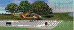
Scenery add-on for France VFR Alsace VFR base pack.
Ingwiller - Hopital du Neuenberg is located 40 kms north-west of Strasbourg city. The helipad is mainly used by the french Securite Civile EC-145 "Dragon 67".
Not tested without France VFR Alsace VFR base pack but should be compatible with default scenery.
By HAUGER Fredo.
| Filename: | Ingwiller__Hopital_du_Neuenberg.zip |
| License: | Freeware |
| Added: | 22nd February 2012, 17:50:29 |
| Downloads: | 262 |
| Author: | HAUGER Fredo |
| Size: | 437.08 KB |
| Category: Flight Simulator 2004 - Scenery | |
| Ile d'Aix France Photo real |
|
File Description:
Photo scenery of "Ile d'Aix", small island between La Rochelle and Fort Boyard France.
Includes no mesh but provides customized autogen.
| Filename: | Ile_dAix_France_Photo_real.zip |
| License: | Freeware |
| Added: | 8th July 2006, 13:43:19 |
| Downloads: | 1,725 |
| Author: | Alain Nicco |
| Size: | 344.94 KB |
| Category: Flight Simulator 2004 - Scenery | |
| Drop Zone Die (France/Drome) |
|
Images related to this file:
File Description:

FS2004 Scenery.
Drop Zone Die (France/Drome) scenery add-on for FS2004. Drop Zone is located in Die close to French Alps in the region called Drome.
By HAUGER Fredo.
| Filename: | Drop_Zone_Die_FranceDrome.zip |
| License: | Freeware |
| Added: | 7th June 2013, 17:52:08 |
| Downloads: | 132 |
| Author: | Hauger Fredo |
| Size: | 744.23 KB |
| Category: Flight Simulator 2004 - Scenery | |
| Franco-Australian Memorial - Villers-Bretonneux - France. |
|
File Description:
The Villers-Bretonneux Memorial is the Australian National Memorial erected to commemorate all Australian soldiers who fought in France and Belgium during the First World War, to their dead, and especially to those of the dead whose graves are not known. Villers-Bretonneux is a village 16 kilometres east of Amiens.
| Filename: | FrancoAustralian_Memorial__VillersBretonneux__Fran.zip |
| License: | Freeware, limited distribution |
| Added: | 3rd February 2011, 20:22:41 |
| Downloads: | 506 |
| Author: | Stephane DAVRANGE |
| Size: | 5.22 MB |
© 2001-2026 AVSIM Online
All Rights Reserved
Privacy Policy |